342_HS1-416511228_319.1 Flying Discs 1949
Investigation reading
This Release 01 item is a 143-page scanned PDF packet, not a single incident report. It collects Flight Service, MATS, Project SIGN, Air Weather, AACS, and related military correspondence about “flying discs,” unidentified flying objects, luminous atmospheric events, radar/scope anomalies, and reporting procedures from 1948 through early 1950.
The source review treats the released PDF as the source of record. The file copy available through Open Sky was verified at 123,253,043 bytes with SHA-256 707639e26003ce0c4f317b379626092d56af0f5a73db52cd91d4af184009c515; PDF metadata reports 143 pages, and the embedded page-image inventory shows one 300-ppi RGB scan image per page. The Frontier OCR text has 143 page markers and text on all 143 pages. Several low-text pages are reverse-side bleed-through, transmission covers, or mostly blank/illegible copies rather than missing source coverage.
The reading below uses the OCR and graph extraction as indexes into the packet, not as adjudication. Diagram-heavy and visual pages were checked against rendered page images, including the Guam/Rota radar-scope sketch, Kodiak course maps, Japan phenomenon/weather charts, the Fairfield-Suisun trajectory map and aerial photograph, and the Jackson sketch. This draft does not resolve the historical reports. It identifies what the released file appears to contain, where the custody trail is clear, where the graph has useful context, and what a human reviewer should check next.
Evidence media
- Official PDF access copy: Open Sky release-file PDF
- The images below are derived page renders from the official PDF. They show source pages referenced in the draft; they are not separate standalone photographs unless the caption says the source page itself is an aerial/base photograph.
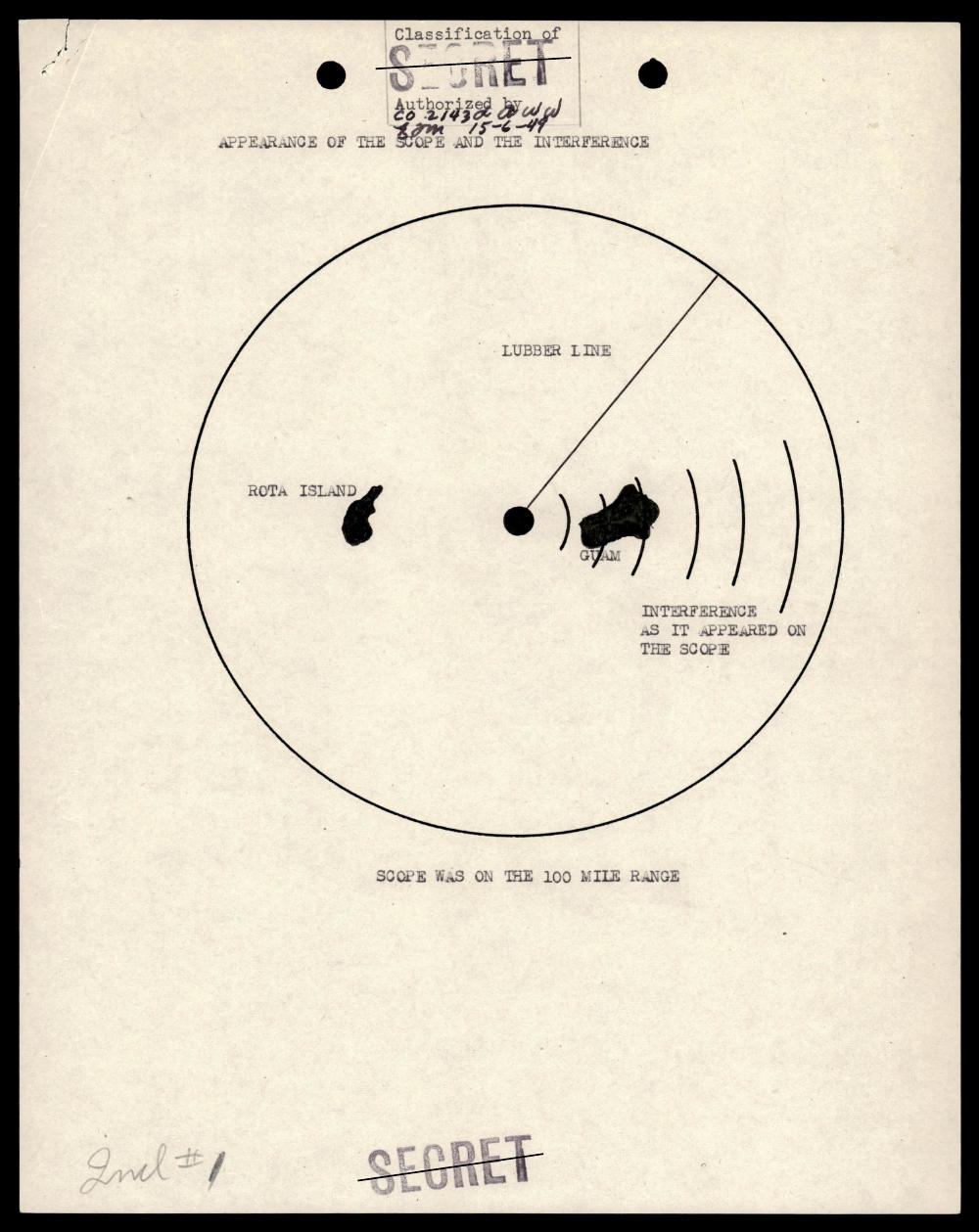
Page 50: source radar/scope diagram titled “APPEARANCE OF THE SCOPE AND THE INTERFERENCE,” showing Rota Island, Guam, a lubber line, interference markings, and the note that the scope was on the 100-mile range.
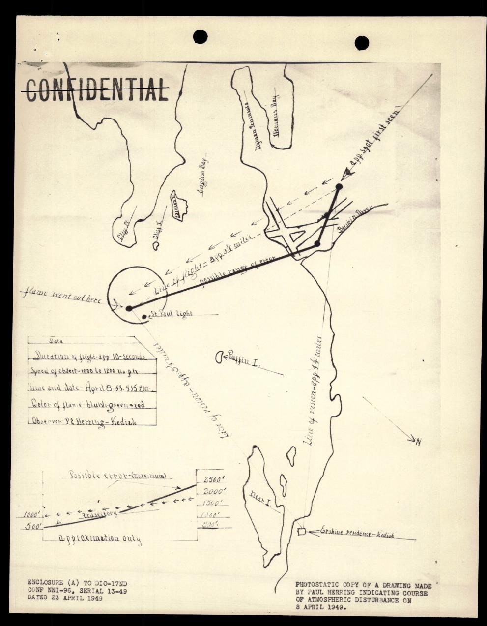
Page 57: hand-drawn Kodiak-area map page with waterways/islands, course annotations, observation/data notes, and a small trajectory/elevation sketch dated April 1949.
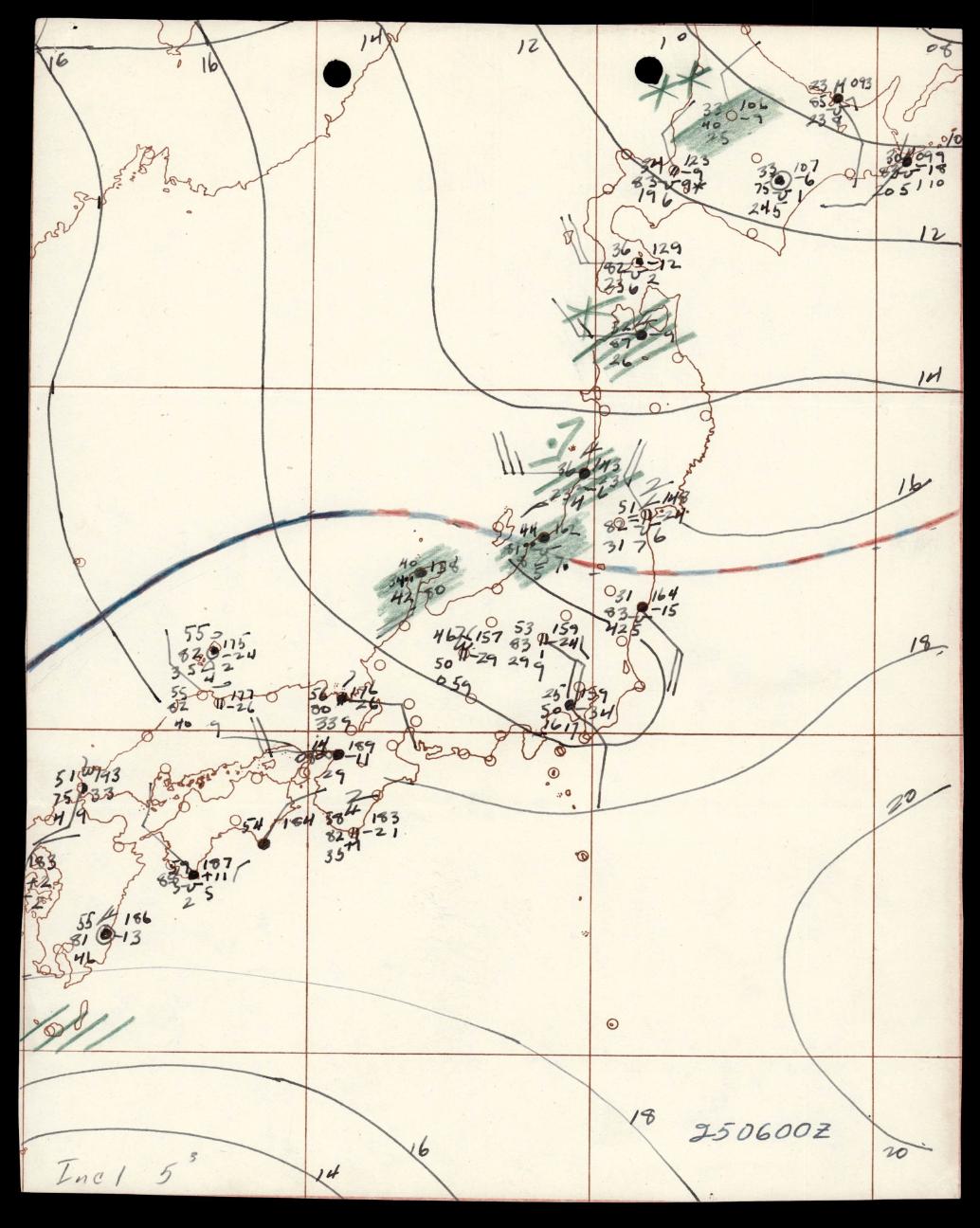
Page 88: Japan packet map/weather-chart page with gridded coastlines, station-style symbols, contour-like lines, numeric labels, and shaded markings. It is meteorological/chart material, not object imagery.
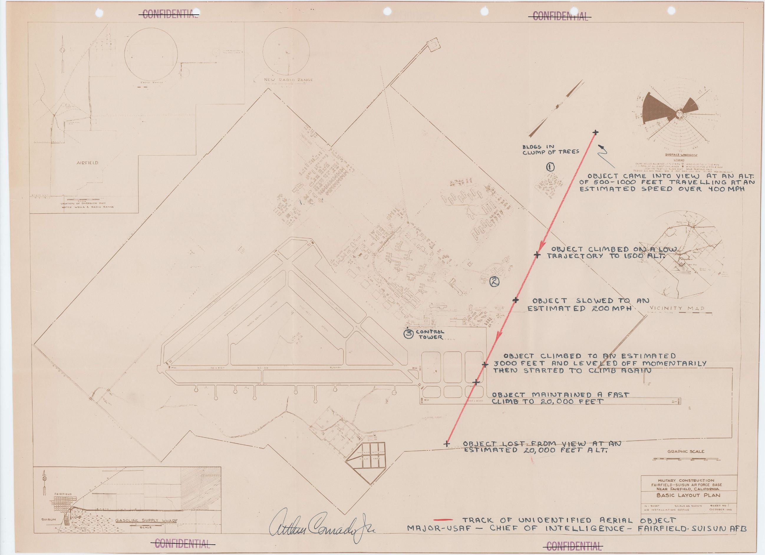
Page 101: Fairfield-Suisun Air Force Base layout plan with a marked track and handwritten altitude/speed annotations for an “unidentified aerial object.” The track markings appear to be part of the scanned source document, not modern annotation.
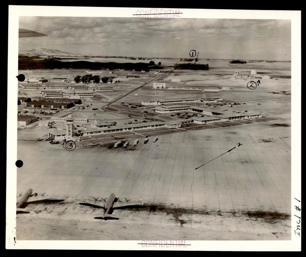
Page 114: source page containing an aerial/base photograph of the Fairfield-Suisun area with runways, aircraft, numbered callouts, arrows, and classification markings. It is contextual base imagery, not a photograph of the reported aerial object.
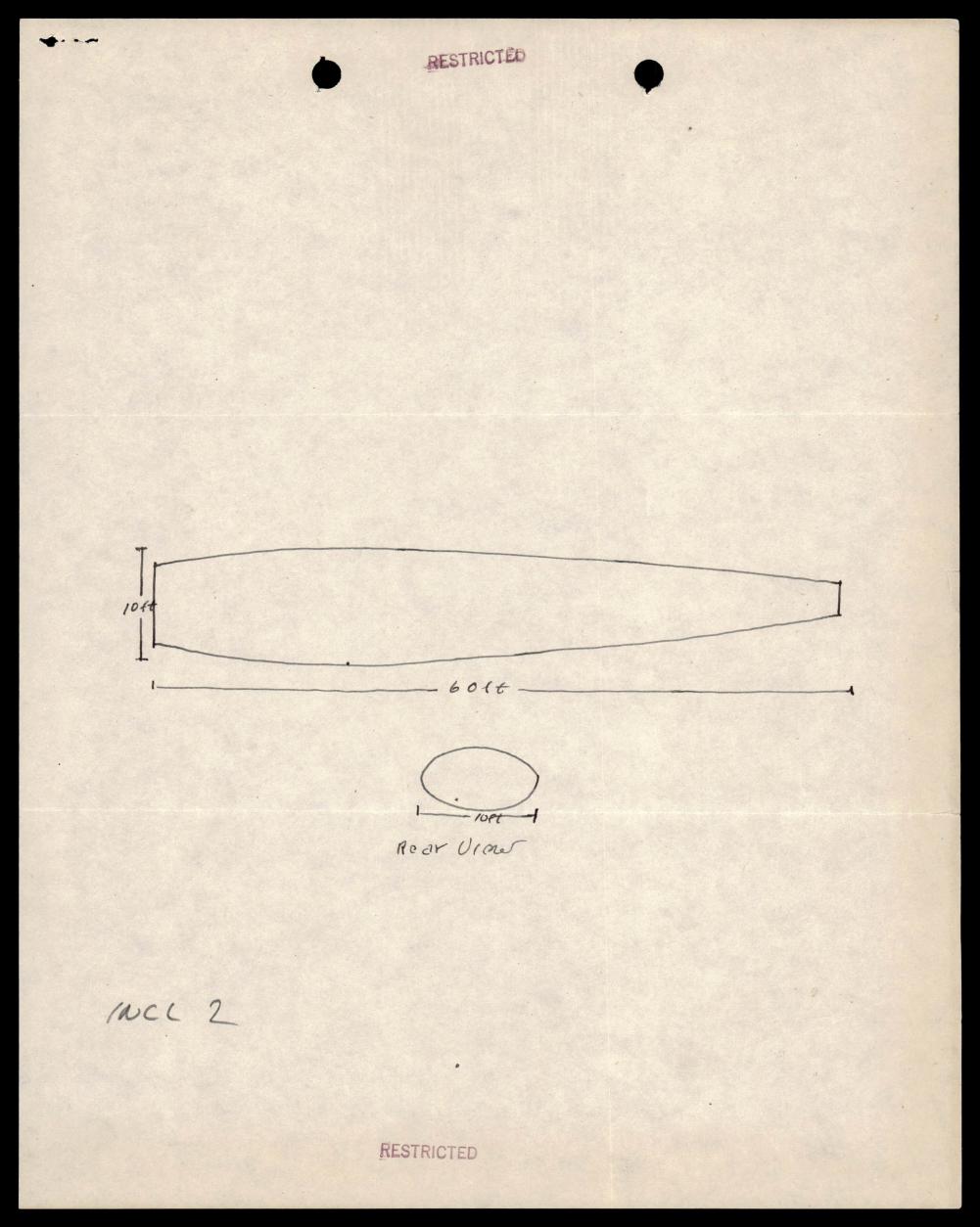
Page 120: source sketch page with side and rear views of the Jackson object report. The rendered page supports an approximately 60-foot by 10-foot reading; OCR alone can misread the labels as 600/100.
What the file appears to contain
At a high level, the packet is an archive bundle of short reports and message traffic. It mixes primary witness narratives, military forwarding letters, teletyped summaries, standard sighting-data forms, hand-drawn course maps, weather notes, radar/scope context, and several explicit prosaic leads. Many pages are reverse sides, bleed-through copies, or duplicated/forwarded versions of the same report.
Page-range inventory
| Pages | What is in this part of the packet |
|---|---|
| 1-2 | Lowry Flight Service Center report on two bright spherical objects seen over Kansas City/Olathe on 6 January 1950. The report says no photos were available and sketches were expected separately. |
| 3-8 | Olmsted Flight Service Center report for 20 September 1949 near Griffiss AFB/Rome, New York, from a C-45 crew. The object is described as silvery/cylindrical with flame, descending into overcast; the report says no radar sightings and no photos. |
| 9-13 | McChord Flight Service Center reports for Seattle-area sightings on 22 August 1949, including a circular aluminum-colored object and a separate aircraft-like object near Seattle-Tacoma/Olympic Mountains. No photos or sketches are reported. |
| 14 | Maxwell Flight Service Center report for Greenville, South Carolina, 15 August 1949. The object is described as round, large, gray, and moving northeast; the report states the 316th Troop Carrier Wing later attributed it to a Geological Weather Service balloon believed released in Tennessee. |
| 15-21 | McChord reports for Spokane, Washington, and Medford, Oregon, late July/August 1949. These include a formation of dish-shaped objects, shiny objects with variable speed, and witnesses reporting formation changes; the packet does not provide object photographs. |
| 22-24 | Wright-Patterson report on a Columbus, Ohio, 1 August 1949 object seen at high altitude, changing from white to yellowish red. |
| 25-27 | McChord report involving Captain Thrush of a Northwest Airlines Martin 202 near Portland/Stevenson, Washington, on 1 August 1949. The report describes aircraft-like lights and an attempted visual follow-up; it notes a C-82 in the vicinity. |
| 28-31 | McChord/Mountain Home, Idaho, 24 July 1949 report from Harry Clark, including a formation of objects larger than an F-51, darker than normal aluminum, and seen during flight. |
| 32-34 | Wright-Patterson report on a Columbus, Ohio, 20 July 1949 luminous object described as a flying-wing or swept-wing form, observed in straight-line flight. |
| 35-42 | Wright-Patterson/Olmsted reports for late June and 10 June 1949, including a flame/smoke report and an airborne sighting of a white tubular object. The June 10 form says no radar sightings and lists ordinary flight/weather checks as unknown or not obtained. |
| 43-45 | Hamilton Field message traffic relaying a Salt Lake Air Route Traffic Control report near Elko. The text is teletyped and compressed, with aircraft/weather comparisons included. |
| 46-50 | 214th Air Weather Wing material from Okinawa/Pacific operations. One thread describes RB-29 radar interference near Guam/Rota; another describes a high-altitude white billowing substance. Page 50 is the radar-scope diagram for the reported interference. |
| 51-57 | Kodiak, Alaska, “luminous energy” intelligence reports for April 1948 and April 1949. The visual pages are hand-drawn course maps of an atmospheric disturbance attributed to Paul Herring’s drawing, with duration, speed, color, and course notes. |
| 58-59 | Carswell/Fort Worth, Texas, April 1949 report describing a silver ball-shaped object seen from the flight line; the report says no photographs were available and notes a flight-following radar check. |
| 60-64 | Goose Bay/Fort Chimo/Fort Pepperrell message traffic. These pages include both a March 1949 red-light object report and a February 1949 engine-sound report in which no object or lights were seen. |
| 65-68 | March AFB/Sandberg Pass, California, February 1949 report of an object described as jet-propelled and circling an aircraft. The report says size/shape details were not available. |
| 69-70 | Project SIGN note about a British aircraft-recognition journal photo caption for the Chance-Vought V-173/XF5U-1 “Flying Saucer.” This appears to be an aircraft-recognition/reference item rather than a sighting narrative. |
| 71-74 | Fort Pepperrell/Newfoundland February 1949 message traffic about a burning object seen while witnesses waited for a bus. Follow-up pages preserve location details but are partly faint or blank reverse-side copies. |
| 75-78 | 6th Weather Squadron report on objects seen near the San Andres Islands in February 1949. The file preserves balloon and ship/free-flight possibilities but says those possibilities do not fully account for all three objects within the short sighting window. |
| 79-82 | Godman Field/Fort Knox, Kentucky, 7 February 1949 report of a bright green/yellow/red rotating object tracked by weather observers with a theodolite. |
| 83-89 | Japan abnormal-glow/meteorological phenomenon packet for 25 January 1949, including Fukushima, Iida, Suwa, and Takayama weather-station reports, a probable-path map, and weather charts. The Fukushima text says the object was “probably” a meteor, while the packet preserves multiple station reports and maps. |
| 90-98 | Hickam Field/AACS material on Captain Paul R. Stoney’s 4 January 1949 “flying disc” observation. The report describes a flat white object, regular blinking/reflection, no photos, and a C-54/R5D-related possibility raised by the witness and checked in message traffic. |
| 99-114 | Fairfield-Suisun AFB Project SIGN report for 3 December 1948. This is one of the packet’s densest sections: control-tower observations, a white-light description, altitude/speed estimates, no radar acquisition, a winds-aloft balloon release 35-45 minutes before the sighting, a trajectory map over the base layout, and an annotated aerial/base photograph. |
| 115 | MATS/AACS note on a 4 January 1949 bright-light report over Indian House Lake, Canada. The message text preserves a possible shooting-star/meteor interpretation and says only the light was seen, not the object body. |
| 116-120 | Weather detachment report for Jackson, Mississippi, 1 January 1949, describing a dark cigar-like/sleeve-target-like object, with a source sketch showing a roughly 60-foot by 10-foot side view and a 10-foot rear view. |
| 121 and 141 | Edmonton/Alberta-to-Northwest Territories flight report, dated November 1948, describing a bright orange egg-shaped object with a tail and a shallow-dive impression. The packet appears to preserve this report in separated pages. |
| 122-129 | Olmsted/Martinsburg, West Virginia, 11 December 1948 report from a C-45F flight. The object is described as red-blue-red, flare-like, brilliant, and apparently stationary; no radar sighting is reported. |
| 130-131 | Headquarters USAF reporting instructions for “flying discs,” including standard categories of location, weather, witnesses, photographs, sketches, shape, size, color, speed, heading, altitude, and related checks. |
| 132-136 | A second Maxwell/Jackson copy of the 1 January 1949 Mississippi report, giving more detail on the Stinson aircraft context, no camera, Associated Press notice, and sketch preparation. |
| 137-140 | Chanute AFB weather-observer report and statements for 6 December 1948, describing a bright white round object or skyrocket/meteor-like object moving from northeast toward south-southwest. |
| 142-143 | Additional reporting-instruction traffic emphasizing prompt reporting, investigative detail, and photographic evidence where available. |
The packet therefore functions less like a finished case file and more like a working archive bundle: multiple reports, several forwarded copies, and mixed evidentiary value across pages.
Visual material checked in the file
- Page 50 contains a source radar/scope sketch showing Guam, Rota Island, a lubber line, and interference bands on a 100-mile range scope.
- Pages 53 and 57 contain hand-drawn Kodiak-area course maps for an “atmospheric disturbance,” with observation data boxes and altitude/course sketches.
- Pages 87-88 contain a Japan probable-path map and a weather chart for the January 1949 abnormal-glow reports.
- Page 101 contains a Fairfield-Suisun base layout plan with a track line and handwritten altitude/speed callouts for an unidentified aerial object. These marks are part of the scanned source document, not modern Open Sky annotation.
- Page 114 contains an aerial/base photograph of the Fairfield-Suisun area with numbered callouts and arrows. It documents base geography and sighting context; it does not show the reported aerial object.
- Page 120 contains the Jackson object sketch. The visual sketch reads as approximately 60 feet long and 10 feet in diameter, matching the report text more closely than the noisy OCR.
Source custody and provenance
- Official/source URL: https://www.war.gov/medialink/ufo/release_1/342_hs1-416511228_box186_319.1-flying-discs-1949.pdf
- Open Sky release-file access copy: war-gov-342-hs1-416511228-319-1-flying-discs-1949-218e167f
- SHA-256:
707639e26003ce0c4f317b379626092d56af0f5a73db52cd91d4af184009c515 - Official CSV row:
25 - Agency: Department of War
- Container: scanned, encrypted/copy-disabled PDF, 143 pages, 123,253,043 bytes
- OCR status in Open Sky:
frontier_ocr_complete, with 143 OCR pages containing text - The PDF metadata title/subject matches the visible file title:
342_HS1-416511228_box186_319.1 Flying Discs 1949
The direct official media URL may be access-controlled for automated requests. The Open Sky release-file route should be treated as a cached access copy of the official release payload, verified by the SHA-256 hash above, not as a separate source.
Graph context
Open Sky’s graph has one primary Document record for this asset and one related official release-record document for CSV row 25. The asset record is modeled as an official-primary PDF asset with the canonical WAR.GOV URL and the hash shown above.
The graph currently preserves:
1020extracted source-text claim records423entity mentions78sensor/platform event records91OCR chunks for the released PDF text0extracted table rows0candidate crosslinks for this item in the current release graph context
The extraction is useful for navigation, especially for recurring themes such as object descriptions, motion, witness testimony, radar, aircraft-platform context, weather checks, photographs/sketches, balloons, and missing data. It is also noisy in predictable ways: long packets create repeated claims, generic words such as “aircraft,” “photograph,” and “radar” can become broad media or sensor labels, and forwarded copies can duplicate the same source fact. Graph records should therefore guide review rather than replace a page-by-page reading.
Leads to check
- Separate the packet into distinct incident-level child pages or graph case clusters before making any cross-case claim. This PDF combines many reports that should not be flattened into one event.
- For the Greenville and San Andres sections, check contemporary weather-balloon launch records, winds aloft, and source-unit correspondence before accepting or rejecting the prosaic leads stated in the file.
- For the Guam/Rota radar-scope section, compare the radar-interference diagram against the surrounding RB-29 test-hop text, equipment checks, and any 514th Reconnaissance Squadron maintenance or mission records.
- For the Kodiak and Japan luminous-phenomenon sections, compare the source maps with astronomical/meteor records and weather-station logs for the stated dates and times.
- For the Hickam and Fairfield-Suisun sections, separate witness-estimated altitude/speed from measured data. Both sections contain possible conventional leads, but neither should be summarized from a single sentence.
- For the Jackson sketch, use the visual source page rather than OCR alone; the OCR can misread the drawn dimensions.
- Identify which pages are duplicate forwarding copies, reverse-side bleed-through, or separated continuation pages so the graph does not over-count repeated facts.
Lead check notes
- Partial — incident-level splitting: The page-range inventory separates the packet into report clusters, and the current graph context lists no candidate crosslinks for this item. Exact local wiki search did not surface separate curated pages for Fairfield-Suisun, San Andres, Guam/Rota, Hickam/Stoney, or Jackson. Child case pages should wait until duplicate source copies and adjacent Release 01 OCR records are compared.
- Partial — Greenville and San Andres prosaic leads: Page 14 states that the 316th Troop Carrier Wing attributed the Greenville report to a Geological Weather Service balloon believed released in Tennessee. Pages 75-77 preserve San Andres balloon/free-flight possibilities, including Managua and ship-track alternatives, but the source text itself says those possibilities do not account for all three objects. External balloon-launch logs and winds-aloft records are still needed.
- Checked — Guam/Rota radar-scope context: Pages 46 and 50 align internally: the text describes a 2 May 1949 RB-29 test hop by a 514th Reconnaissance Squadron radar operator, while the rendered diagram shows Guam, Rota Island, a lubber line, and interference markings on a 100-mile scope. Maintenance records or mission files would still be needed before treating the interference cause as resolved.
- Partial — Kodiak and Japan luminous-phenomenon checks: The PDF includes Kodiak course-map pages attributed to Paul Herring and Japan station/weather pages for Fukushima, Iida, Suwa, Takayama, and related probable-path material. Local wiki search did not surface separate curated event pages for these anchors. External astronomy, meteor, and weather-station logs remain the next checks.
- Partial — Hickam and Fairfield-Suisun measurement separation: Hickam pages preserve a C-54/R5D check and the witness’s warning that speed was hard to estimate because of distance and intermittent reflection. Fairfield-Suisun pages preserve tower observations, no radar acquisition, witness-estimated altitude/speed, and a winds-aloft balloon release 35-45 minutes before the sighting. These are review leads, not measured resolution data.
- Checked — Jackson sketch/OCR conflict: The rendered sketch page supports the draft’s 60-foot by 10-foot reading, while OCR text can misread the dimensions as 600/100. Page 136 also states no photographs were taken because no camera was available and that sketches were being prepared, so the sketch should be used as context, not object imagery.
- Partial — duplicate and continuation pages: The inventory flags reverse-side bleed-through and separated continuation pages inside this PDF, and broader Release 01 OCR search finds related FBI and incident-summary records for several anchors. Dedupe is still needed before graph counts or incident-level summaries are promoted.
Deep investigation — graph + web reconnaissance
Source reread and visual evidence
This pass rechecked the released PDF as a packet-level source, not as one event. The verified source copy is still the 143-page, 123,253,043-byte official-primary PDF with SHA-256 707639e26003ce0c4f317b379626092d56af0f5a73db52cd91d4af184009c515. The OCR and rendered pages continue to support the main boundaries already used in the page-range inventory: early Flight Service UFO reports, 214th Air Weather Wing Pacific material, Kodiak luminous-energy reports, San Andres weather-squadron notes, Hickam/AACS correspondence, Fairfield-Suisun Project SIGN material, Jackson Weather Detachment reports, and USAF reporting instructions.
Representative visual reread tightened three evidence limits:
- Page 50 is a radar/scope diagram titled “APPEARANCE OF THE SCOPE AND THE INTERFERENCE,” with
ROTA ISLAND,GUAM, aLUBBER LINE, interference arcs, and the note that the scope was on the 100-mile range. It is a source diagram of reported interference, not object imagery. - Page 114 is an annotated aerial/base photograph of Fairfield-Suisun with runways, aircraft, numbered callouts, and ground arrows. It is contextual base photography for the report, not a photograph of the reported aerial object.
- Page 120 is a source sketch page. The side-view and rear-view labels support the approximately
60 ftby10 ftreading; the page is a drawn report exhibit, not a capture of the object.
The OCR/source text also preserves several built-in prosaic lanes: Greenville is attributed in the packet to a Geological Weather Service balloon believed released in Tennessee; the Kodiak witnesses discuss meteor/shooting-star comparisons while disagreeing with that interpretation; Hickam preserves a C-54/R5D check and a light-material/funneled-air possibility; Fairfield-Suisun records no radar acquisition and a winds-aloft balloon release 35-45 minutes before the sighting; and Jackson records no camera/photographs, weather fields, and a sketch rather than direct imagery.
Graph connections and semantic audit
The graph has one primary Document for the PDF asset, one related official release-record document for current CSV row 25, one Source node for the WAR.GOV/PURSUE Release 01 collection, and a secondary UFO-USA Markdown conversion node linked as a comparison derivative. Direct graph relationships for the asset include HAS_EXTRACTED_CLAIM, HAS_CHUNK, DESCRIBES_SENSOR_EVENT, RELATED_TO, DERIVED_FROM, and INGESTED_FROM.
Current semantic coverage for this asset remains machine indexed rather than adjudicated: 1020 Claim nodes, 423 EntityMention nodes, and 78 SensorEvent nodes are all marked machine_extracted_needs_human_review / not_a_finding. The graph has 93 TextChunk links for the asset context, including manifest/description chunks; the release OCR baseline remains 91 OCR chunks. Claim-kind counts are dominated by observation, witness-testimony, time, object-description, and motion labels, with only 9 prosaic-lead claims. Sensor labels are useful as navigation cues but noisy: the RADAR hits include both actual radar/scope material and repeated “no radar sightings” form language, while many aircraft/photograph hits are ordinary platform, witness, or missing-photo references.
Text matching in the wider graph found counterpart leads, not conclusions. Fairfield-Suisun appears in the official PDF, the secondary UFO-USA conversion, Project Blue Book material such as NARA-PBB89, and Project SIGN microfilm-derived records. Jackson Weather, Godman Field, Kodiak, and Hickam also appear in older Blue Book/Project SIGN/FBI or secondary collections. These matches are valuable crosswalk targets for future child pages, but exact reel/page/NAID alignment still needs source-page pinning before any merged case narrative is promoted.
External provenance and official-source context
The canonical public source remains WAR.GOV/PURSUE Release 01 and the official media URL: 342_hs1-416511228_box186_319.1-flying-discs-1949.pdf. During this check, direct automated requests to the official media URL returned HTTP 403 from the WAR.GOV edge server, while the Open Sky release-file access copy verifies against the official-release hash and byte count. That is an access/custody note, not evidence that the file has changed.
NARA/Project Blue Book and Project SIGN remain the highest-priority external official-context lanes because graph text matches indicate overlapping material for several embedded reports. Read-only graph reconnaissance surfaced official NARA Catalog leads for Fairfield-Suisun AFB, California, July 1949 - Incident Number: 401 (catalog.archives.gov/id/28935898), Kodiak, Alaska, April 1949 (catalog.archives.gov/id/28934086), Hickam Fld, Hawaii, January 1949 - Incident Number: 236 (catalog.archives.gov/id/28932824), and Indian House Lake, Canada, January 1949 (catalog.archives.gov/id/28932910). Those are provenance/crosswalk targets, not merged citations yet: the exact source pages, Project SIGN reel/page references, and duplicate-copy boundaries still need to be pinned before any child-case narrative is promoted. Community or GitHub conversions are useful only for text comparison and OCR rescue, not as a substitute for the official WAR.GOV packet or older official microfilm/catalog sources.
Prosaic checks and unresolved work
Because this PDF spans many dates and locations, one packet-level astronomy/weather/launch/satellite check would be misleading. A bounded graph check of typed AstronomyEvent, WeatherEvent, and LaunchEvent records for representative dates in the packet returned no exact matches for 1948-04-08, 1948-12-03, 1949-01-01, 1949-01-25, 1949-05-02, or 1950-01-06; this does not replace incident-specific station logs, meteor records, balloon records, aircraft traffic, or radar maintenance files. The pre-spaceflight dates also mean satellite correlation is not a meaningful lane for the 1948-1950 reports.
Next investigative work should split the packet into child clusters before escalation: Guam/Rota radar-interference maintenance records; Kodiak and Japan meteor/weather-station records; Greenville, San Andres, Fairfield-Suisun, and Hickam balloon/aircraft checks; Jackson weather and Stinson-aircraft witness statements; and exact duplicate-page reconciliation against Project SIGN, Blue Book, FBI Vault, and NARA holdings. Until those child checks are pinned, this page should remain a source-grounded packet overview with unresolved subreports, not a finding.
Audit note
This section distinguishes source facts, witness testimony, graph machine extraction, external crosswalk leads, and prosaic checks. No graph writes were made, and no finding, hypothesis, or resolution decision is asserted.
Limits
- This is an investigation draft awaiting human review. It does not assert that any described object was extraordinary, resolved, or unexplained.
- The packet includes reports with very different evidentiary strength: direct witness statements, controller reports, weather-station reports, radar/scope notes, hearsay-forwarded message traffic, drawings, and administrative reporting instructions.
- Many source pages are carbon copies, reverse sides, or bleed-through scans. Some handwriting, stamps, and teletyped fields remain partly illegible.
- Several reports explicitly say photographs were unavailable. Where maps, sketches, or photographs appear, they document report context and annotations; they are not object imagery unless the specific source page says so.
- Dates, places, and page ranges in this page are summarized from OCR plus rendered-page checks of the released PDF and should be compared against the original page images during human review.
Sources
- Department of War, PURSUE Release 01, official PDF: 342_HS1-416511228_319.1 Flying Discs 1949
- Open Sky release-file access copy: /api/explore/war-gov/release-file/war-gov-342-hs1-416511228-319-1-flying-discs-1949-218e167f
- Open Sky source dataset:
war_pursue_uap_release_2026_05_08 - Open Sky semantic dataset:
war_pursue_release01_semantic_2026_05_12 - Hash checked for the released PDF:
707639e26003ce0c4f317b379626092d56af0f5a73db52cd91d4af184009c515