DOW-UAP-D10, Mission Report, Middle East, May 2022
Evidence media
- Official PDF: Open Sky release-file copy · WAR.GOV source
Derived page renders below are from the official PDF. They are source-document pages, not standalone sensor frames or object photographs.
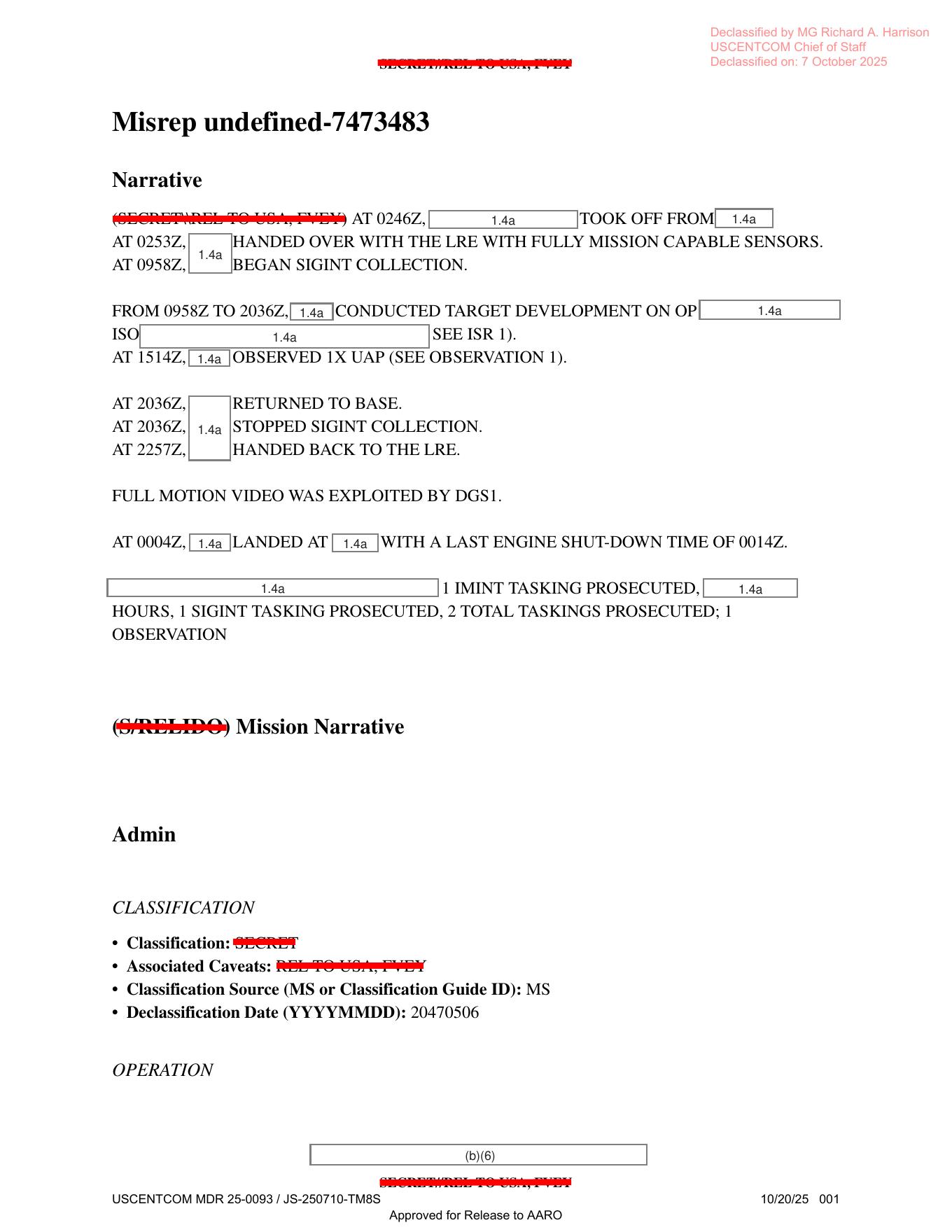
Page 1 preserves the mission narrative and release markings. The visible text includes the reported 1514Z observation reference, tasking totals, and the statement that full-motion video was exploited by DGS1.
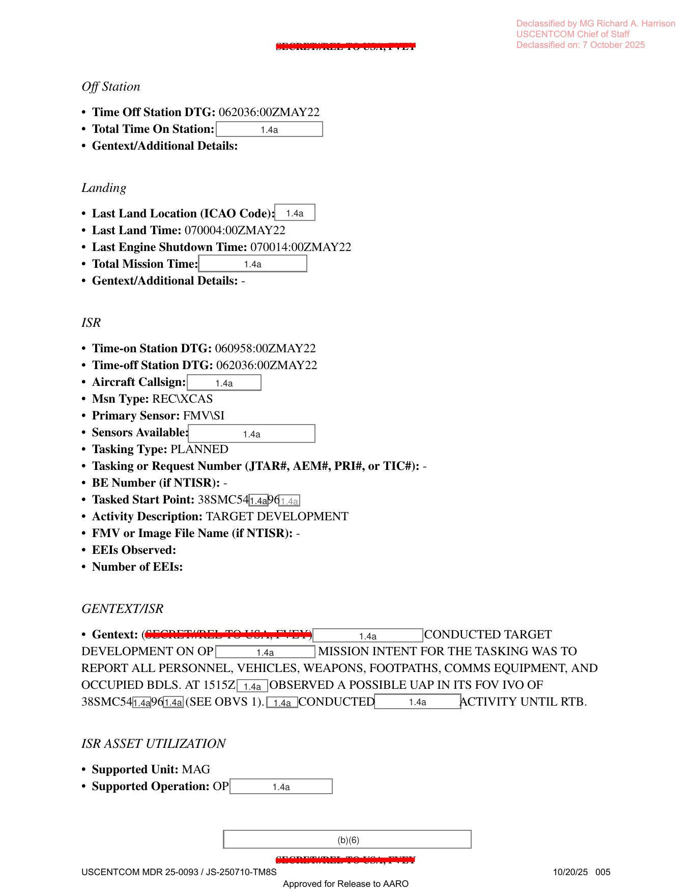
Page 5 preserves ISR/tasking context around the observation. The visible form fields include a primary-sensor entry beginning with FMV, planned target-development tasking, a redacted MGRS-like start point beginning 38SMC54...96..., and a GENTEXT/ISR sentence saying a possible UAP was observed in the field of view.
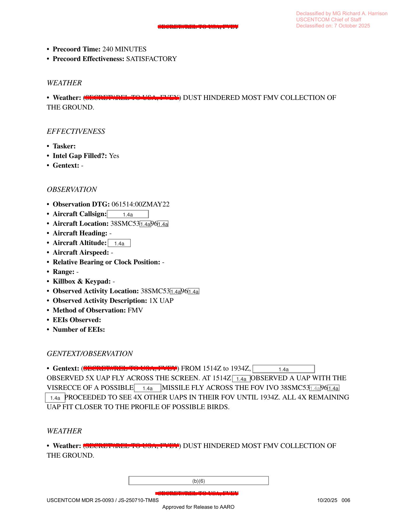
Page 6 is the key observation page. The visible source text gives Observation DTG 061514:00ZMAY22, method of observation FMV, an observed activity description of 1X UAP, wording that 5X UAP crossed the screen from 1514Z to 1934Z, one possible [redacted] missile phrase, four remaining UAP fitting closer to possible birds, and the weather note that dust hindered most FMV collection of the ground.
Investigation reading
This release item is a six-page mission report, not a photo packet or a standalone video file. The file records a May 2022 USCENTCOM/AFCENT air-domain mission associated with Operation Inherent Resolve. Its strongest public value is the structured mission context around a reported FMV observation: the form preserves mission timing, ISR tasking, weather limits, and a short observation narrative stating that five UAP crossed the screen between 1514Z and 1934Z.
The document should be read as source custody and operational-context evidence for the paired Release 01 video item, not as an adjudicated conclusion. The report itself uses tentative operator language. One object is described in relation to a possible missile; the remaining four are described as fitting closer to possible birds. The page therefore stays in graph_investigation_draft status with needs_human_review and not_a_finding.
What the file appears to contain
The PDF has six visible text/form pages. A rendered-page check shows no embedded photographs, maps, sensor plots, object stills, radar scopes, or diagrams. All six pages contain typed MISREP-style fields, release/declassification markings, and heavy redactions under classification and privacy exemptions.
| Page | Investigation notes |
|---|---|
| 1 | Mission narrative. The mission takes off at 0246Z, is handed over to the LRE at 0252Z, begins SIGINT collection at 0055Z, conducts target development from 0955Z to 2036Z, and records one UAP observation at 1514Z. The page also says full-motion video was exploited by DGS1 and summarizes one IMINT tasking, one SIGINT tasking, two total taskings, and one observation. |
| 2 | Administrative mission metadata. Visible fields identify Operation Inherent Resolve, domain Air, Operations Center 609th, AFCENT, USCENTCOM, report type MISREP, mission type XCAS, country tasked United States, and service tasked Air Force. Contact and unit details are mostly redacted. |
| 3 | Approver/ingest and aircraft-equipment fields. The form includes aircraft callsign, radar, radar warning receiver, missile warning system, IRCM, ECM, chaff, and related equipment prompts, but many fields are blank or redacted. This page is a form context page, not independent radar evidence. |
| 4 | Aircraft/weapons/timeline fields. The page includes takeoff and on-station timing, number of aircraft, asset type, tail number, takeoff location, Mode 3/IFF, mission type RECXCAS, and other mostly redacted fields. |
| 5 | Off-station, landing, and ISR sections. It records off-station and landing timing, mission type RECCE/CAS, primary sensor FMVISI, target-development tasking, and a GENTEXT/ISR paragraph saying the mission was to report personnel, vehicles, weapons, footpaths, communications equipment, and occupied buildings. The OCR also captures a possible UAP reference in the ISR narrative, but with multiple illegible/redacted fields. |
| 6 | Weather, effectiveness, and observation section. It states precoordination time of 240 minutes, precoordination effectiveness satisfactory, weather/dust hindered most FMV collection of the ground, Intel Gap Filled marked Yes, observed activity description 1X UAP, method of observation FMV, and the high-signal GENTEXT/OBSERVATION paragraph. |
The key observation text is on page 6. The stored OCR reads, in part: “FROM 1514Z to 1934Z, [redacted] OBSERVED 5X UAP FLY ACROSS THE SCREEN ... [redacted] PROCEEDED TO SEE 4X OTHER UAPS IN THEIR FOV UNTIL 1934Z. ALL 4X REMAINING UAP FIT CLOSER TO THE PROFILE OF POSSIBLE BIRDS.” The released page image appears to render the observation DTG as 061514:00ZMAY22; the OCR/graph text currently carries 061514:02MAY22, so that time-field discrepancy should be checked against the source image before any exact structured correction.
Source custody and provenance
- Official PDF URL: https://www.war.gov/medialink/ufo/release_1/dow-uap-d10-mission-report-middle-east-may-2022.pdf
- Open release-file route: /api/explore/war-gov/release-file/war-gov-dow-uap-d10-mission-report-middle-east-may-2022-c1c59236
- SHA-256:
f9deed9063306b0c45a5a0f6b754db6967f7dc3a0ed66097f154be4b0f033399 - File size verified against release metadata:
663290bytes - PDF page count:
6 - OCR coverage:
6pages with text - Agency: Department of War
- Release: Release 01
- Incident date/location from release record: May 6, 2022 / Iraq
- Related release context: the graph connects this mission report to DOW-UAP-PR19, a five-second DVIDS video item titled “Unresolved UAP Report, Middle East, May 2022.”
The custody record is official-primary for the released PDF and the release record. The file is heavily redacted; exact aircraft, personnel, coordinates, altitude, callsign, and some wording remain unavailable in the public copy.
Graph context
The graph currently models this asset as a Document with an official WAR.GOV PDF URL, official-primary provenance, and the same SHA-256 listed above. It also has a separate Release 01 record document for CSV row 35, plus related records for the paired PR19 video/report and a nearby PR22 Syria/July 2022 release record.
The semantic graph contains 114 extracted source-text claims, 75 entity mentions, and 9 sensor-event records for this item. Treat those records as navigation aids. Several sensor-event labels come from form prompts or equipment fields such as radar, IR-guided AAM, RWR, FMVISI, and aircraft fields; the released PDF does not include raw radar plots, raw IR frames, or object imagery. The strongest sensor-context line in the source is that the observation method was FMV and that full-motion video was exploited by DGS1.
No candidate crosslinks are currently attached to this asset. The useful graph trail is therefore: official PDF asset -> Release 01 record -> paired PR19 video/report -> source-text claims and OCR chunks.
Leads to check
- Review the paired DOW-UAP-PR19 video and metadata beside this mission report. The PDF gives context; the video is the item that reportedly depicts an area of contrast moving left to right across the lower third of the sensor field of view.
- Resolve the observation-time discrepancy: the rendered page appears to show
061514:00ZMAY22, while stored OCR/graph text has061514:02MAY22. - Recheck the exact page-6 wording around “VISRECCE” / “presence” and “possible [redacted] missile.” The page image and OCR differ enough that a human transcription pass should decide the exact quotation.
- Reconcile the related-row metadata: the release metadata/frontmatter uses rows 35 and 76, while the manifest description and related graph records also surface row 79 / PR22 context. This may be a release-record linkage issue rather than an evidentiary connection.
- Compare the redacted MGRS-style activity locations on pages 5 and 6. OCR variants such as
3SSMC5E,3SSMC5Y, and visually apparent38SMC53...96...should not be treated as exact coordinates without manual source-image review. - Check whether the weather/dust statement affects interpretation of the FMV clip, especially ground collection limits versus object-in-field-of-view visibility.
Lead check notes
- Partial — paired PR19 video/source record: the current linked corpus includes a DOW-UAP-PR19 page and DVIDS source record for the five-second Middle East 2022 video. Its release description says an infrared-sensor clip shows an area of contrast moving left to right across the lower third of the sensor field of view, while DOW-UAP-D10 supplies the mission-report context. A frame-level PR19 review remains separate from this PDF page.
- Checked — observation-time discrepancy: the page-6 render visibly supports
061514:00ZMAY22; the stored OCR text for this PDF still carries061514:02MAY22and is the only exact OCR-corpus hit for that variant. Treat the:02value as an extraction/transcription issue until the source-text record is corrected. - Partial — page-6 wording: the page render visibly favors
VISRECCE OF A POSSIBLE [redacted] MISSILErather than the OCR phrasepresence of a possible ... missile. Redactions and degraded type still leave this as a human-transcription lead, not a resolved quotation. - Partial — related-row metadata: release metadata checked here ties this PDF to row 35 and the paired PR19 row, while another related Release 01 record surfaces PR22/Syria context. That remains a release-record linkage cleanup item; it does not add an evidentiary connection to this D10 report without source-page comparison.
- Partial — MGRS-style locations: page 5 visibly begins around
38SMC54...96...; page 6 visibly begins around38SMC53...96...; OCR reduces both to noisy3SSMC5...variants. The redacted digits prevent a public exact coordinate. - Needs external source — weather and visibility: page 6 states that dust hindered most FMV collection of the ground. Whether that affected interpretation of the object in the paired IR clip still requires PR19 frame review, platform/sensor geometry, and independent weather/visibility context.
Deep investigation — graph + web reconnaissance
Source reread
A fresh source pass focused on pages 5 and 6 because they carry the operational and observation language. Page 5 visibly supports an ISR tasking with mission type RECXCAS, planned target development, a primary sensor field that appears as FMVVSI/FMVISI in OCR-sensitive rendering, and a GENTEXT/ISR sentence saying that at about 1515Z a redacted observer saw a possible UAP in the field of view near a partially redacted grid fragment beginning 38SMC54...96.... The redactions prevent reconstruction of a public coordinate.
Page 6 is the strongest source page. The rendered page supports Observation DTG 061514:00ZMAY22, observed activity description 1X UAP, method of observation FMV, and a GENTEXT/OBSERVATION passage stating that from 1514Z to 1934Z a redacted observer saw 5X UAP FLY ACROSS THE SCREEN. The same passage says the 1514Z object was described with OCR-sensitive wording that visually favors VISRECCE OF A POSSIBLE [redacted] MISSILE moving across the field of view near a partially redacted 38SMC53...96... location, and then says the four remaining UAP fit closer to the profile of possible birds. The page repeats the weather note that dust hindered most FMV collection of the ground.
Those are source facts and source-language characterizations, not Open Sky findings. The render-vs-OCR discrepancy matters: the stored OCR/graph text still carries 061514:02MAY22 and presence of a possible ... missile, while the rendered page supports 061514:00ZMAY22 and visually favors VISRECCE/similar wording. Any future exact quotation should cite the rendered page image or a corrected text layer.
Graph connections
Read-only Neo4j review found three relevant official Document records around this asset: the Release 01 row-35 D10 record, the PDF asset record with SHA-256 f9deed9063306b0c45a5a0f6b754db6967f7dc3a0ed66097f154be4b0f033399, and a row-79 record whose title/URL fields currently surface PR22/Syria-vs-D10 linkage tension. The D10 asset record has 9 text chunks, 114 machine-extracted claims, 9 machine-extracted sensor-event records, and 0 candidate crosslinks attached directly to the asset.
The graph's useful human-review trail is narrow: D10 PDF asset -> Release 01 row 35 -> paired PR19/DVIDS video ID 1006056. Sensor-event nodes are marked machine_extracted_needs_human_review and not_a_finding; several come from MISREP equipment prompts such as radar/RWR/IR-guided weapon fields rather than from raw radar, raw IR, or independent telemetry. The source-backed sensor context is FMV/full-motion-video exploitation, not released instrument data.
A graph/data hygiene note remains open. Current graph and manifest records disagree across row numbers and paired assets: the D10 page/frontmatter use rows 35 and 76; the asset inventory description also mentions row 79; a PR19 release-record node carries DVIDS ID 1006056 but has a suspicious D74 PDF final URL; and the PR22 row appears to point at the D10 PDF URL. Treat this as release-record linkage cleanup, not an evidentiary connection between unrelated cases.
External provenance and paired-video check
Official web checks found the DVIDS page live at https://www.dvidshub.net/video/1006056/dow-uap-pr19-unresolved-uap-report-middle-east-may-2022 with the title DOW-UAP-PR19, Unresolved UAP Report, Middle East, May 2022. DVIDS metadata visible during this check lists video ID 1006056, VIRIN 220501-D-D0360-6497, filename DOD_111688723, category B-Roll, length 00:00:05, location (UNDISCLOSED LOCATION), date taken 05.01.2022, date posted 05.07.2026 23:17, and courtesy video credited to AARO. The DVIDS MP4 endpoint answered a range request with 206 and bytes 0-15/6814452, and the returned header bytes include an MP4 ftyp box. Direct WAR.GOV PDF/landing/CSV fetches during this check returned 403, so the public page relies on the already verified release-file copy and the recorded official release metadata for the WAR.GOV PDF.
The paired PR19 MP4 was reopened as media context. Container review confirms a 5.4-second H.264 stream at 1920 x 1080, 30 fps, with an AAC audio stream. Sampled frames show a monochrome sensor-style display with reticle/bracket overlays, black mask blocks, heavy compression/noise, and ambiguous lower-third contrast features. The public clip is compatible with the DVIDS description of an unresolved contrast area moving across the lower third, but the visible frames do not provide scale, range, platform geometry, sensor mode, full observation span, or enough resolution to identify the feature.
Prosaic checks and limits
The source itself supplies the first ordinary-explanation lanes: possible [redacted] missile for the 1514Z object and possible birds for the four later objects. The dust/weather line is also source text and should be kept in play because it limits ground FMV collection and may affect contrast interpretation. Additional ordinary checks remain open for aircraft, munitions, birds, ground-scene parallax, sensor-display artifacts, compression artifacts, atmospheric/dust effects, and line-of-sight ambiguity.
Astronomy, satellite/reentry, launch, and conventional weather correlation cannot be responsibly run from the public record alone because the exact coordinates, platform position, altitude, range, look angle, and much of the time/location context are redacted. The public incident geography is only Iraq/Middle East-level, while the visible grid fragments are incomplete. These checks need an unredacted or higher-fidelity source packet before they can move beyond generic possibilities.
Follow-up leads
- Reconcile the D10/PR19/PR22 row-number and final-URL tensions in the release graph without promoting any relationship to a finding.
- Correct or annotate the OCR/text-layer discrepancy for page 6:
061514:00ZMAY22vs061514:02MAY22, andVISRECCE/similar wording vspresence. - Seek an authoritative source FMV export or release note that maps the five-second PR19 clip to the D10
1514Zobservation and distinguishes it from the four later possible-bird observations. - Look for unredacted or less-redacted platform/sensor metadata: field of view, sensor mode, altitude, range, look angle, exact grid, and frame timestamps.
- Treat the DVIDS
05.01.2022date-taken metadata and the D1006MAY22observation date as a custody/date-cleanup item until DVIDS/WAR.GOV or AARO explains the mismatch.
Audit note
This section was added from the source PDF/OCR/rendered pages, paired official DVIDS media, read-only graph review, and official web checks. No Neo4j writes were made, and no Finding, Hypothesis, or ResolutionDecision conclusion is asserted here.
Limits
This page does not resolve the event. The PDF is a redacted mission report with no embedded object imagery and no raw sensor data. The “possible missile” and “possible birds” phrases are source/operator descriptions, not Open Sky conclusions. The form contains many equipment prompts that can look like sensor evidence in extraction, but the public PDF mostly preserves fields and narrative text rather than instrument outputs.
The incident location is only public at the Iraq/Middle East level in the release record and manifest context. Exact platform, altitude, range, callsign, coordinates, and parts of the observation wording are redacted or illegible. Any public analytical page should cross-check this report against the paired video, mission timeline, weather conditions, and ordinary bird/missile/aircraft possibilities before escalation.
Sources
- Department of War Release 01 PDF: https://www.war.gov/medialink/ufo/release_1/dow-uap-d10-mission-report-middle-east-may-2022.pdf
- Open Sky release-file copy: /api/explore/war-gov/release-file/war-gov-dow-uap-d10-mission-report-middle-east-may-2022-c1c59236
- WAR.GOV Release 01 record page: https://www.war.gov/UFO/#release-01-record-35-98af7203
- Related DVIDS video record surfaced by the release graph: https://www.dvidshub.net/video/1006056/dow-uap-pr19-unresolved-uap-report-middle-east-may-2022