DOW-UAP-D12, Mission Report, Iraq, May 2022
Evidence media
- Official PDF: Open Sky release-file copy · WAR.GOV source
Derived page renders below are from the official PDF. They are source-document pages, not standalone sensor frames or object photographs.
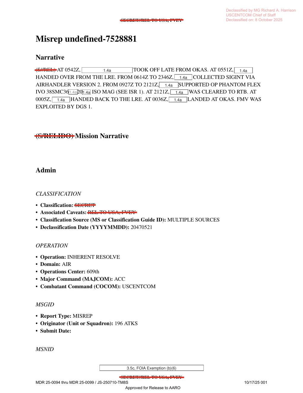
Page 1 preserves the mission narrative and release markings. The visible text gives takeoff from OKAS at 0542Z, SIGINT collection via Airhandler Version 2 from 0614Z to 2346Z, OP PHANTOM FLEX support from 0927Z to 2121Z, return clearance at 2121Z, handback at 0005Z, landing at 0036Z, and the statement that FMV was exploited by DGS 1.
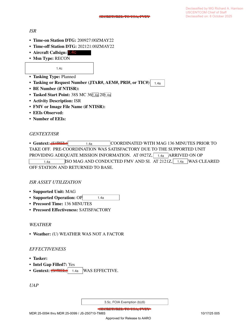
Page 5 preserves the ISR/tasking context. The visible form fields show time on station 200927:00ZMAY22, time off station 202121:00ZMAY22, a redacted MGRS-style task start point beginning 38S MC 36...20..., FMV and SI activity in support of MAG, and the source statement that weather was not a factor.
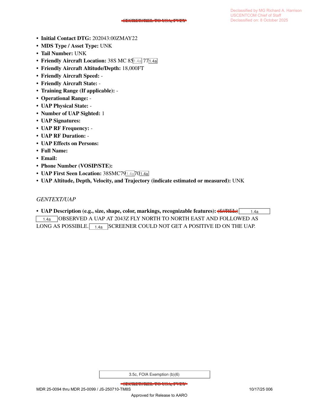
Page 6 is the key UAP form page. The visible source text gives Initial Contact DTG 202043:00ZMAY22, friendly aircraft altitude 18,000FT, one UAP sighted, UAP altitude/velocity/trajectory UNK, a redacted first-seen location beginning 38SMC79...70..., and the GENTEXT statement that the UAP was observed at 2043Z flying north to northeast before a screener could not get a positive identification.
Investigation reading
This is a six-page, text-form Mission Report (MISREP) released in WAR.GOV/PURSUE Release 01. The report is not a photo packet and not a video exhibit. It is a redacted operational form for an Air Force reconnaissance mission connected to Operation Inherent Resolve, with a final UAP section reporting one observed object on 20 May 2022 in Iraq.
The key UAP passage appears on page 6. The form records an initial contact time of 202043:00ZMAY22, one UAP sighted, unknown asset type and tail number, friendly aircraft altitude of 18,000FT, partially redacted MGRS-style locations, and an unknown UAP altitude/depth/velocity/trajectory field. The GENTEXT/UAP line says a redacted observer saw a UAP at 2043Z flying north to northeast and followed it as long as possible; a screener could not get a positive identification.
This draft is a graph_investigation_draft; it needs human review and does not assert a finding or resolution.
What the file appears to contain
The released PDF is a MISREP-style form with struck-through classification markings, declassification markings by MG Richard A. Harrison, and repeated AARO release footer text. All six rendered pages are text/form pages; no page contains photographs, maps, diagrams, radar plots, sensor screenshots, or embedded UAP imagery.
| Page | Public reading |
|---|---|
| 1 | Mission narrative and administrative metadata. The sortie took off late from OKAS at 0542Z, handed over from the LRE at 0551Z, collected SIGINT via Airhandler Version 2, supported OP PHANTOM FLEX, was cleared to return at 2121Z, and landed at OKAS after handback. The page also says FMV WAS EXPLOITED BY DGS 1. |
| 2 | Tasking and personnel/contact sections. The mission type is RECONNAISSANCE, the country tasked is listed as US - UNITED STATES, the service tasked as A - AIR FORCE, with POC/QC/approver names and contact details redacted. |
| 3 | ACEQUIP/equipment checklist. Most radar, RWR, MWS, IRCM, ECM, chaff/flare, weapon, and data-link fields are blank. The visible filled fields are an aircraft callsign redaction, TGT Pod Name or Designator: ANDAS4, and Additional Avionics: AHv2. |
| 4 | Mission timeline. The form gives one aircraft, OKAS takeoff at 200542:00ZMAY22, Mode 3/IFF code 2232, on-station time 200551:00ZMAY22, killbox 89AS, off-station time 210005:00ZMAY22, total time on station 18 hours 14 minutes, last land time 210036:00ZMAY22, and engine shutdown at 210046:00ZMAY22. |
| 5 | ISR section. The form gives ISR time on station 200927:00ZMAY22 to 202121:00ZMAY22, mission type RECON, a redacted aircraft callsign, a partially redacted tasking/start point, and a GENTEXT/ISR passage saying the mission was coordinated with MAG 136 minutes before takeoff, arrived on operation at 0927Z, conducted FMV and SI, and was cleared off station at 2121Z. Weather is marked WEATHER WAS NOT A FACTOR; Intel Gap Filled? is Yes. |
| 6 | UAP section. This is the substantive UAP page: initial contact 202043:00ZMAY22; asset type and tail number UNK; friendly aircraft altitude 18,000FT; number of UAP sighted 1; UAP first-seen location partially redacted; UAP altitude/depth/velocity/trajectory UNK; GENTEXT says a redacted observer saw a UAP at 2043Z fly north to northeast and followed it as long as possible, but a screener could not get a positive ID. |
Several form fields are blank, hyphenated, UNK, or redacted. The report preserves a reported observation and operational context, not an adjudication.
Source custody and provenance
- Official PDF: https://www.war.gov/medialink/ufo/release_1/dow-uap-d12-mission-report-iraq-may-2022.pdf
- Open Sky release-file copy: war-gov-dow-uap-d12-mission-report-iraq-may-2022-9a0a2d62
- Release manifest row:
36 - Agency: Department of War
- Source type: PDF MISREP
- File size:
670302bytes - PDF page count:
6 - OCR coverage:
6pages with text - SHA-256:
00afb60938d05101a62d0af41fdfc6749612fcea806d90d5a1035a9dc874afb5
The Open Sky release-file copy matches the manifest hash above. The PDF has an encrypted/copy-restricted flag, but text extraction and rendered-page inspection were still possible for this draft.
Graph context
Open Sky currently models this item as both a Release 01 record and a PDF asset. The record node points to WAR.GOV Release 01 row 36 and carries the public incident metadata: incident date 5/20/22, location Iraq, and redaction marked true. The asset node points to the canonical PDF URL and preserves the same SHA-256 value.
The graph has 74 extracted claim records, 61 entity mentions, 9 sensor-event records, and no candidate crosslinks for this item. Those graph records are useful navigation cues, but many of the sensor/platform hits come from form prompts or ordinary mission fields: FMV, DGS 1, SIGINT, aircraft, radar/RWR/IR checklist labels, targeting-pod fields, and blank or redacted equipment lines. They should not be read as raw radar tracks, IR imagery, object photos, or independent instrument confirmation unless a separate source file provides that evidence.
The UAP-specific graph content is concentrated on the page 6 form fields and GENTEXT/UAP sentence. The strongest source-backed statement is narrow: the released MISREP says a redacted observer reported one UAP flying north to northeast at 2043Z, followed it as long as possible, and a screener could not positively identify it.
Leads to check
- Locate any paired or downstream FMV/DGS product, if it exists, because this PDF says FMV was exploited but the released PDF itself contains no image frames or video.
- Compare the partially redacted MGRS-style friendly-aircraft and first-seen locations with any non-publicly redacted release materials, if legally available, before trying to map the geometry.
- Reconcile OCR/text-layer differences in mission timing fields. The direct text layer and rendered page read
0614Z to 2346Z,0927Z to 2121Z,0005Z,0036Z, and engine shutdown210046:00ZMAY22; older OCR text in the graph appears to preserve some different values. - Check whether
ANDAS4,AHv2, Airhandler Version 2, DGS 1, MAG, and the relevant OKAS/killbox context can identify the platform, sensor suite, or operating environment without exposing redacted information. - Preserve weather as a source statement only: page 5 says weather was not a factor, but no independent meteorological reconstruction is included in this PDF.
- Confirm whether the release includes any separate DVIDS item, video, still image, or AARO case summary tied to this MISREP; this PDF alone does not provide visual evidence of the object.
Lead check notes
- Partial — paired PR20 still-image source: Release 01 metadata includes a separate official PDF,
DOW-UAP-PR20, Unresolved UAP Report, Kuwait, May 2022(row77), whose manifest description explicitly says an accompanying mission report,DoW-UAP-D12, described the UAP moving north to northeast. PR20 describes a still image derived from a U.S. military system with a reporter-added red circle. That still-image source needs separate review; no DVIDS/MP4 item tied to D12 appears in the current Release 01 metadata. - Partial — redacted locations and geometry: page 5 render/text layer support task start point
38S MC 36[redacted]20[redacted]; page 6 supports friendly-aircraft location38S MC 85[redacted]77[redacted]and UAP first-seen location38SMC79[redacted]70[redacted]. The redactions prevent exact public coordinate plotting without another source. - Checked — timing transcription: the render/text layer support
0614Zto2346ZSIGINT,0927Zto2121ZOP PHANTOM FLEX/ISR,0005ZLRE handback,0036Zlanding, and210046:00ZMAY22engine shutdown. Existing OCR variants such as2146Z,009Z,0030Z, or210040should be treated as transcription artifacts unless the source image is re-read differently. - Partial — equipment/platform abbreviations: page 3 render/text layer support
ANDAS4andAHv2; OCR variantsANDA54andAIV-2remain transcription-review leads. Those abbreviations, Airhandler Version 2, DGS 1, MAG, OKAS, and killbox89ASprovide mission context only; platform/sensor identification still needs source material that is not redacted in this PDF. - Checked — weather statement, not reconstruction: page 5 explicitly says weather was not a factor. That is the report's source statement; independent weather, astronomy, and traffic checks would require date/time geometry and external environmental data.
- Partial — same-phrase companion reports: the current linked corpus also contains the
NORTH TO NORTH EASTphrasing in D14/PR21-linked material, but that is a separate Release 01 mission-report/video pair. It is useful for release-family navigation, not corroboration of this D12 event unless page-level source comparison is done.
Deep investigation — graph + web reconnaissance
Source reread
A fresh source pass again centered on the ISR and UAP form pages. Page 5 gives the sortie's ISR window, mission type RECON, FMV and SI activity in support of MAG, a partially redacted MGRS-style tasking/start point, and the source statement WEATHER WAS NOT A FACTOR. Page 6 is the only substantive UAP page: Initial Contact DTG 202043:00ZMAY22, MDS/asset type UNK, tail number UNK, friendly aircraft altitude 18,000FT, Number of UAP Sighted: 1, UAP altitude/depth/velocity/trajectory UNK, and a GENTEXT/UAP sentence saying a redacted observer saw a UAP at 2043Z fly NORTH TO NORTH EAST, followed it as long as possible, and that a screener could not get a positive ID.
The PDF is still a text-form MISREP, not the sensor product itself. The rendered page review found no map, radar plot, object photograph, thermal frame, or video sequence inside D12. The OCR/text layer remains useful but imperfect: it can blur MGRS spacing and redacted digits, and it previously produced variants such as ANDA54/AIV-2 where the page render favors ANDAS4/AHv2 for the equipment fields.
Graph connections
Read-only Neo4j review found two exact official Document records for this item: the Release 01 row-36 record and the PDF asset record with SHA-256 00afb60938d05101a62d0af41fdfc6749612fcea806d90d5a1035a9dc874afb5. The D12 graph neighborhood currently has 9 TextChunk records, 74 machine-extracted Claim records, 9 machine-extracted SensorEvent records, two INGESTED_FROM links to the official WAR.GOV/PURSUE release source, and no direct candidate crosslinks for D12.
The graph's useful source-backed trail is narrow: Department of War / USCENTCOM / AARO release metadata; Iraq and 5/20/22 at the release-record level; FMV and SI activity in the MISREP; one reported UAP at 2043Z; north-to-northeast motion; and inability to make a positive identification. The SensorEvent nodes are marked machine_extracted_needs_human_review and not_a_finding. Several extraction hits come from form prompts or ordinary mission fields, so they should not be read as independent radar, IR, RF, or telemetry confirmation.
Graph and wiki review also tied D12 to PR20, the one-page still-image sheet titled DOW-UAP-PR20, Unresolved UAP Report, Kuwait, May 2022. That pairing is context, not a merge: D12 is the mission report; PR20 is the annotated still-image release product. PR20 preserves a release-metadata tension because its title says Kuwait while the structured release record and paired D12 context point to Iraq.
External provenance and paired-still check
Direct official WAR.GOV checks for the D12 PDF, PR20 PDF, Release 01 landing page, and CSV manifest returned 403 during this check, so the page relies on the already verified Open Sky release-file copy, the recorded Release 01 metadata, and the cached source-pack hash for file integrity. Exact-title web reconnaissance found secondary mirrors for D12 and PR20, including Disclosdex pages for PURSUE Release 01: DOW-UAP-D12, Mission Report, Iraq, May 2022 and PURSUE Release 01: DOW-UAP-PR20, Unresolved UAP Report, Kuwait, May 2022, plus an Unexplainable.com PR20 page. Those secondary pages repeat the north-to-northeast / positive-ID / Iraq-vs-Kuwait points, but they are discovery and comparison leads only; the official release file and manifest remain the provenance anchor.
The paired PR20 still-image render was reopened as context. It is a one-page annotated still image with DoD open-publication clearance, USCENTCOM recommendation text, black redactions, cyan display symbology, and a red circle around a small bright elongated mark in the upper-left portion of the frame. The red circle and display symbology are part of the released still-image product, not proof of motion. PR20 does not provide a time-stamped sequence, raw telemetry, platform geometry, field of view, range, or unannotated original frame.
Prosaic checks and limits
The source itself supplies a limited ordinary-check baseline: the report says weather was not a factor, but it gives no independent weather reconstruction; it says FMV was exploited by DGS 1, but it does not release the full FMV, sensor mode, or analyst worksheet; it gives partial MGRS-style coordinate fragments, but redactions prevent a public exact geometry. A read-only graph probe found no matching astronomy, weather, or launch-event correlation records keyed to Iraq / 2022-05-20, but that absence is not a resolution because the exact time/location/platform geometry is still withheld.
The main prosaic lanes remain image/sensor and operating-environment checks before escalation: compression or small-pixel artifacts in PR20, annotation bias from the reporter-added red circle, line-of-sight ambiguity, ordinary aircraft or drone traffic, military activity in Operation Inherent Resolve airspace, weather/visibility despite the source statement, and whether the still image corresponds to the D12 observation time at all. None of those can be closed from the public D12 PDF alone.
Follow-up leads
- Seek an authoritative unannotated PR20 frame, adjacent frames, or raw FMV export that can be tied to D12's
2043ZUAP line without relying on title/manifest inference alone. - Reconcile D12/PR20 location metadata: D12 says Iraq; PR20's public title says Kuwait while its structured release context says Iraq.
- Resolve OCR-sensitive fields against page renders before exact quoting:
ANDAS4/AHv2, the38S MC...coordinate fragments, andNORTH TO NORTH EASTwording. - Identify platform/sensor geometry only from lawful, source-backed material: platform type, sensor mode, field of view, range, look angle, altitude, and exact grid.
- Keep D12's 9 machine-extracted sensor events as navigation cues until each is source-verified; do not convert them into findings.
Audit note
This section was added from the source PDF/OCR/rendered pages, paired PR20 rendered still image, read-only graph review, official-web availability checks, and secondary web reconnaissance. No Neo4j writes were made, and no Finding, Hypothesis, or ResolutionDecision conclusion is asserted here.
Limits
This page does not resolve the event. The report is heavily redacted and leaves the asset type, tail number, UAP physical state, UAP signatures, RF frequency/duration, UAP altitude/velocity/trajectory, and full coordinate values unknown or blank. The document contains no photographs, no radar plots, no thermal imagery, no object frames, and no witness interview beyond the form text.
The direction of travel, count of one, and failed positive identification are documented as report contents. They are not, by themselves, evidence of extraordinary origin or a prosaic explanation. Any escalation would need the missing media/sensor products, platform geometry, location context, timing reconciliation, and independent environmental checks.
Sources
- Department of War, WAR.GOV/PURSUE Release 01,
DOW-UAP-D12, Mission Report, Iraq, May 2022, official PDF: https://www.war.gov/medialink/ufo/release_1/dow-uap-d12-mission-report-iraq-may-2022.pdf - WAR.GOV Release 01 manifest record, row
36, titleDOW-UAP-D12, Mission Report, Iraq, May 2022. - Related Release 01 still-image source record,
DOW-UAP-PR20, Unresolved UAP Report, Kuwait, May 2022, row77: https://www.war.gov/medialink/ufo/release_1/dow-uap-pr20.pdf - Open Sky release-file copy for public browsing: war-gov-dow-uap-d12-mission-report-iraq-may-2022-9a0a2d62