DOW-UAP-D14, Mission Report, Iraq, May 2022
Evidence media
- Open Sky release-file copy: open the nine-page official PDF.
- Related official video: open the paired
DOW-UAP-PR21release-file video or the DVIDS source page. Release metadata pairs PR21 with this D14 mission report and describes ten seconds from an infrared sensor; the video should still be reviewed on its own page before merging the PDF and video into a single analytic narrative.
Derived page renders from the official PDF
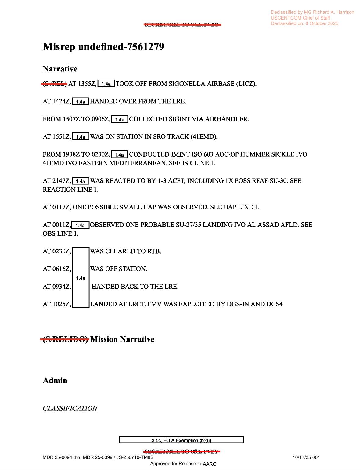
Page 1 is the mission narrative page. It summarizes takeoff from Sigonella, SIGINT/IMINT tasking, a reaction by possible SU-30 aircraft, the 0117Z possible-small-UAP line, the 0011Z probable SU-27/35 landing line, return-to-base, and FMV exploitation by DGS-IN and DGS4. It is text/form evidence, not a sensor image.
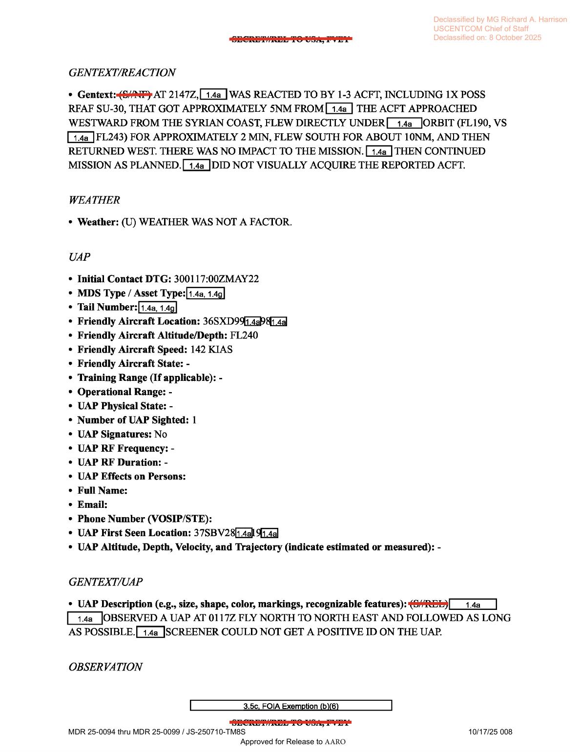
Page 8 preserves the REACTION gentext and the UAP form line: initial contact 300117:00ZMAY22, one UAP sighted, UAP Signatures: No, blank RF frequency/duration fields, and a note that the object was followed north-to-northeast until the screener could not positively identify it. The page does not show imagery, maps, or sensor frames.
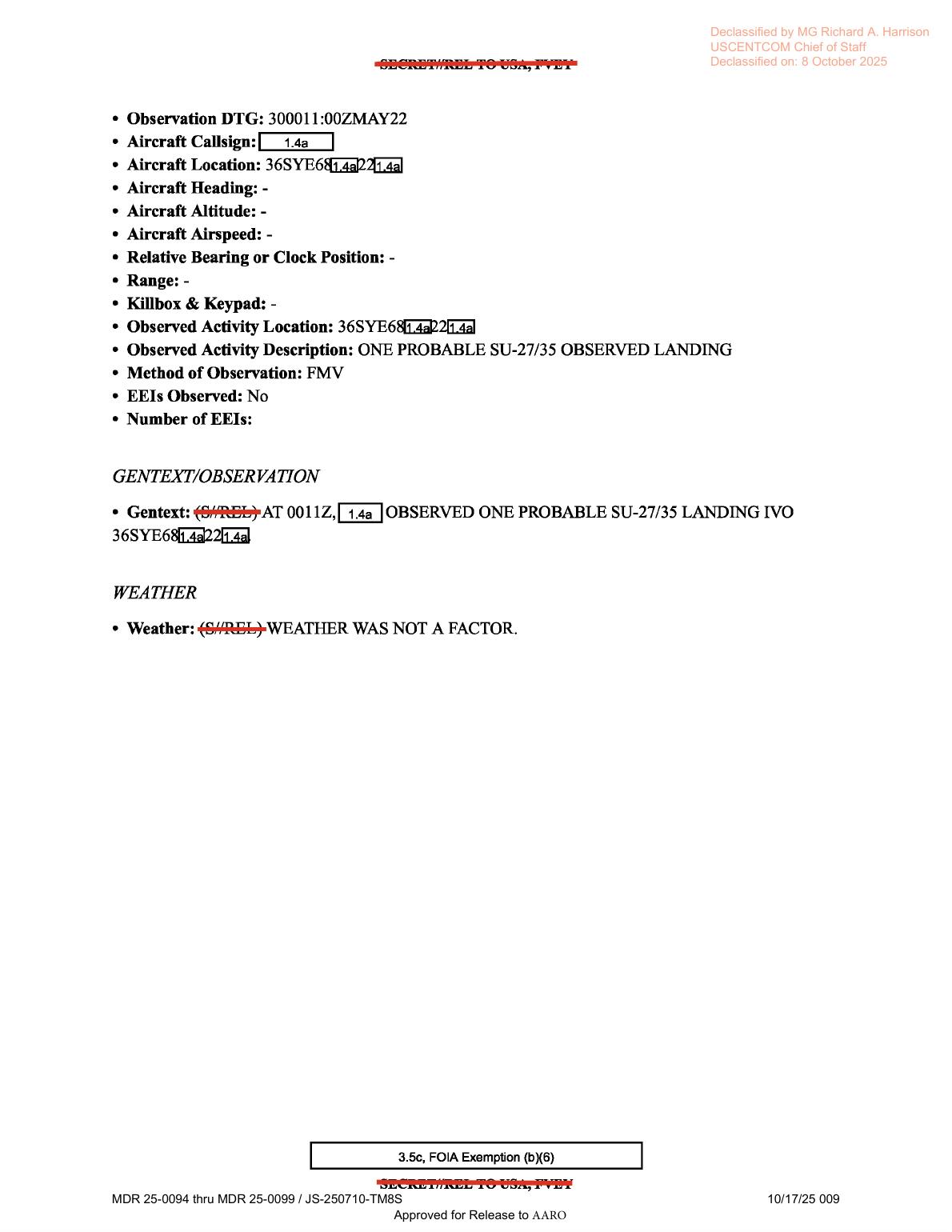
Page 9 is a separate observation line for 300011:00ZMAY22, describing ONE PROBABLE SU-27/35 OBSERVED LANDING with method of observation FMV. It should remain separate from the 0117Z UAP form line unless the paired video or another source record supports merging them.
Investigation reading
This Release 01 item is a nine-page mission report/MISREP, not a standalone visual exhibit. The released PDF is text/form evidence: a declassified mission narrative, administrative fields, equipment prompts, ISR-tasking text, a REACTION section, a UAP section, and a separate OBSERVATION section. The page images show typed report pages with redactions and classification markings; they do not show photographs, maps, radar plots, sensor stills, or diagrams.
The central source statement is narrow. The report records that at 300117:00ZMAY22 one UAP was reported, with the description that the observer saw a UAP at 0117Z fly north to northeast, followed it as long as possible, and that the screener could not get a positive identification. The same report also records a nearby but distinct observation line at 300011:00ZMAY22: one probable SU-27/35 observed landing, with method of observation listed as FMV. Those two lines need to stay separated until a human reviewer checks the paired video and release metadata.
The file also preserves the broader mission context. The aircraft took off from Sigonella Air Base (LICZ), collected SIGINT and IMINT during a long ISR mission, operated around the eastern Mediterranean/Syria-area tasking, and later landed at LRCT. The narrative says FMV was exploited by DGS-IN and DGS4. Weather is repeatedly marked as not a factor, but the released report does not provide raw weather data, raw track data, sensor frames, or unredacted grid coordinates for the UAP.
What the file appears to contain
| Page | Public reading of the released page |
|---|---|
| 1 | Mission narrative. It lists takeoff at 1355Z from LICZ, handoff from the LRE, SIGINT collection, on-station time, IMINT collection in support of 603 AOC\OP HUMMER SICKLE, a 2147Z reaction involving possible SU-30 aircraft, the 0117Z possible small-UAP line, the 0011Z probable SU-27/35 landing line, return-to-base, landing, and FMV exploitation by DGS-IN and DGS4. |
| 2 | Classification, operation, and message-identification fields: SECRET/REL handling, air domain, 603rd, ACC, USEUCOM, MISREP, 50ATKS, ISR mission type, and Air Force tasking fields. |
| 3 | POC/approver and aircraft-equipment fields. Several radar/RWR/MWS fields are present as form prompts but are blank or dashed. |
| 4 | Continued equipment/timeline fields. IRCM/ECM/CMD/weapons prompts are mostly dashed. The page lists target pod ANDAS4, additional avionics AH\SAR, one aircraft, takeoff from LICZ, and landing back at LICZ. |
| 5 | On-station and ISR tasking fields. It gives total mission time as 20 hours 30 minutes, on-station/off-station timing, target-development tasking, an ISR activity description, and 10 EEIs observed. |
| 6 | Dense ISR gentext. It lists many Syrian/eastern-Mediterranean tasking areas and states the collection was looking for RFN surface/subsurface routes, munition handling, and personnel movement. It also lists observed ships/aircraft and ground features, including Slava/Gorshkov/Udaloy vessels, an A-50U, IL-38s, an IL-76, possible radar-dish/generator language, and probable SU-27/35 activity. |
| 7 | Weather/effectiveness/reaction fields. Weather is marked not a factor; Intel Gap Filled? is No. The reaction fields list initial contact 292147:00ZMAY22, friendly aircraft at FL243 and 148 KIAS, two enemy aircraft typed SU-30, nationality RUSSIAN, source of ID NTIG, enemy altitude FL 190, ESM as No, and countermeasures as NONE. Result fields are blank. |
| 8 | Reaction gentext plus the UAP form. The reaction text says one to three aircraft including a possible RFAF SU-30 came within approximately five nautical miles, flew under the orbit for about two minutes, then returned west; the report says there was no mission impact and the reported aircraft was not visually acquired. The UAP section lists initial contact 300117:00ZMAY22, friendly altitude FL240, speed 142 KIAS, one UAP sighted, UAP Signatures: No, no RF frequency/duration, and no altitude/depth/velocity/trajectory value. The UAP description says it flew north to northeast and the screener could not get a positive ID. |
| 9 | Separate observation line. It lists observation DTG 300011:00ZMAY22, observed activity description ONE PROBABLE SU-27/35 OBSERVED LANDING, method FMV, EEIs Observed: No, and weather not a factor. No object image or sensor frame is shown. |
The report is therefore best treated as a short operational form packet: it has a genuine UAP reporting line, but most of the file is mission context, equipment prompts, ISR tasking, and adjacent aircraft/vessel observations.
Source custody and provenance
- Official PDF URL: https://www.war.gov/medialink/ufo/release_1/dow-uap-d14-mission-report-iraq-may-2022.pdf
- Open Sky release-file route: open the released PDF
- SHA-256:
1822564fbae08f152ad4541c8d067a6ec3b6014c4b4eb8209604e1facb5e1bb3 - File size:
7,463,660bytes - PDF page count:
9 - OCR status in the release corpus:
frontier_ocr_complete, with 9 OCR pages and 9 pages containing text - Release record context: CSV row
37identifies the mission report with incident date5/29/22, incident locationSyria, and redaction markedTRUE. Release metadata also links this asset with the relatedDOW-UAP-PR21video record.
The reading above relies on the verified Open Sky release-file copy matched to the official URL and hash. Page render checks confirm that the released PDF is available through the evidence browser.
Graph context
The graph has two exact records for this item: the official release-record document and the PDF asset document. The PDF asset is modeled as an official primary-source document with the canonical WAR.GOV media URL and the verified SHA-256 hash above. The release-record document links the item to the official WAR.GOV release page and to DVIDS video ID 1006059 for DOW-UAP-PR21, Unresolved UAP Report, Iraq, May 2022.
The semantic extraction currently preserves 156 source-text claim records, 111 entity mentions, and 13 sensor-event records for this PDF. Those graph records are useful navigation cues, not findings. Several sensor hits come from form prompts or equipment/context lines (Radar, RWR, IR, FMV, aircraft fields) rather than from raw instrument returns. The strongest source-backed sensor/media terms in the released text are that FMV was exploited by DGS-IN and DGS4, that page 9 lists the SU-27/35 landing observation method as FMV, and that the UAP form itself says UAP Signatures: No with RF frequency/duration left blank.
No candidate crosslinks are currently listed for this asset. Related graph records include the paired DOW-UAP-PR21 video record and a nearby Release 01 DOW-UAP-PR26 record. Those related records should be reviewed on their own pages before merging the PDF, video, and manifest language into one analytic narrative.
Leads to check
- Inspect the paired
DOW-UAP-PR21video record frame by frame and compare it against the PDF's0117ZUAP form line. The PDF page alone does not show the IR video, any frame grab, or the “two areas of contrast” described in the release metadata. - Reconcile the title/location language. The PDF title says Iraq/May 2022, while the release record context for this PDF gives incident location
Syria, and the mission narrative places much of the tasking in the eastern Mediterranean/Syria area. - Keep the
0117ZUAP line separate from the0011ZprobableSU-27/35landing line unless the paired video, manifest row, or human review shows that they refer to the same object/event. - Check the redacted grid references and first-seen location against any unredacted release material, if available. The published PDF leaves important location digits withheld.
- Treat
Weather was not a factoras a source statement, then verify independently if this becomes a case-level investigation. - Review why the graph sensor extraction marks some radar/IR fields as sensor events even when those fields are blank form prompts. That is a data-quality lead, not evidence of radar/IR detection.
Lead check notes
- Partial — Paired PR21 video: release metadata and the linked PR21 evidence page confirm DVIDS video
1006059, paired CSV rows37/81, and MP4 SHA-256af62b4e40a2eb0fd39f98093be2a6ae50271a011e7d5caca2119b26aaabc1212. The PR21 description says the video is ten seconds of infrared-sensor footage with two areas of contrast moving together near the center of the field of view. The video file is present through the Open Sky release-file route, but frame-by-frame comparison against the PDF's0117ZUAP line remains a separate source task. - Checked — Title/location language: the D14 release record gives incident date
5/29/22and locationSyria; PR21 release metadata listsIraq, Syria; the D14 title remainsIraq, May 2022; and the PDF text places much of the mission tasking around the eastern Mediterranean/Syria area. Treat this as release-metadata tension, not a resolved location correction. - Checked —
0117Zversus0011Z: derived page 8 shows the UAP form at300117:00ZMAY22, while derived page 9 shows the separate300011:00ZMAY22probableSU-27/35landing observation. Exact300117:00ZMAY22and300011:00ZMAY22hits in the current linked OCR corpus map to this D14 OCR file, so the page should keep those lines separate until the paired video or another source record supports merging them. - Blocked — Redacted grid references: page 8 preserves redacted UAP location fields (
36SXD99...and37SBV28...), and page 9 preserves a redacted observation location. The current release-file copy does not provide unredacted coordinates; checking the grid lead requires an unredacted source, sensor log, or authoritative case packet. - Needs external source — Weather: pages 7-9 state weather was not a factor, but the PDF does not include raw weather data. Independent weather verification needs the unredacted location/time context and an external weather source.
- Checked — Sensor-extraction data quality: the current graph context includes sensor terms from
FMVlines and also from blank equipment/form prompts (Radar,RWR,IR,MWS). Keep those as extraction-review cues; they are not source evidence that radar or IR detected the UAP in this PDF.
Deep investigation — graph + web reconnaissance
Source reread
A fresh reread focused on the source pages that carry the event language. Page 8 is a text/form page, not imagery: it gives UAP initial contact 300117:00ZMAY22, friendly altitude FL240, speed 142 KIAS, one UAP sighted, UAP Signatures: No, blank RF frequency/duration fields, and no public altitude/depth/velocity/trajectory value for the UAP. Its GENTEXT says a redacted observer saw a UAP at 0117Z flying north to northeast and followed it as long as possible, but the screener could not get a positive ID.
Page 9 is a separate observation form. It gives Observation DTG 300011:00ZMAY22, redacted aircraft and activity locations beginning around 36SYE68..., observed activity description ONE PROBABLE SU-27/35 OBSERVED LANDING, method of observation FMV, EEIs Observed: No, and the repeated source statement that weather was not a factor. The page contains text/form fields only; it does not include a sensor frame, map, radar scope, or photograph. The page-8 UAP line and page-9 SU-27/35 landing line therefore remain separate source statements.
The page-1 narrative preserves both lines in the same mission timeline: 0117Z possible small UAP and 0011Z probable SU-27/35 landing. It also places the mission around Sigonella launch/return handoffs, eastern Mediterranean/Syria-area tasking, SIGINT/IMINT collection, a 2147Z reaction involving possible SU-30 aircraft, and FMV exploitation by DGS-IN and DGS4. Those are operational-context facts in the report, not a resolved identification of the UAP line.
Graph connections
Read-only graph review found the official Release 01 row record, the PDF asset document, and a secondary UFO-USA markdown conversion for the same D14 title/hash family. The PDF asset record carries the official WAR.GOV media URL, official-primary provenance, 7,463,660 bytes, SHA-256 1822564fbae08f152ad4541c8d067a6ec3b6014c4b4eb8209604e1facb5e1bb3, 9 OCR pages, 15 text chunks including manifest/OCR chunks, 156 machine-extracted source-text claims, 13 machine-extracted sensor-event records, and no direct CANDIDATE_CROSSLINK records.
The useful graph trail is D14 PDF asset -> Release 01 row record -> PR21/DVIDS video ID 1006059. The graph also surfaces a row-current linkage wrinkle: D14 connects to a PR21 release-record node and a nearby PR26 row-current node. That is a provenance-cleanup lead, not evidence that the D14 event is connected to the PR26 UAE item.
The graph's source-text claims preserve the key report language: one possible small UAP at 0117Z; a screener unable to get a positive ID; and a separate 0011Z probable SU-27/35 landing. They also preserve the publisher/manifest phrasing that the accompanying mission report described the UAP as a “probable SU-27/35.” Because the source pages separate those two times and forms, the publisher phrasing should be treated as a mapping tension until an authoritative release note, source export, or full sensor packet proves the PR21 clip belongs to one line rather than the other.
External provenance and paired-video check
Official WAR.GOV PDF, landing-page, and CSV fetches returned 403 during this check, so the WAR.GOV custody statement here relies on the previously verified Open Sky release-file copy, graph fetch metadata, and asset inventory. The paired official DVIDS page for PR21 was reachable at https://www.dvidshub.net/video/1006059/dow-uap-pr21-unresolved-uap-report-iraq-may-2022 with title DOW-UAP-PR21, Unresolved UAP Report, Iraq, May 2022. DVIDS metadata visible during this check lists video ID 1006059, VIRIN 220501-D-D0360-5022, filename DOD_111688762, category B-Roll, length 00:00:10, location (UNDISCLOSED LOCATION), date taken 05.01.2022, and date posted 05.07.2026 19:48. The MP4 endpoint responded with content length 12,752,210 bytes and last-modified Fri, 08 May 2026 11:45:13 GMT.
The PR21 contact-sheet review supports only a cautious visual statement. The central crops show a grayscale sensor-display scene with a cyan reticle, an N marker, black mask/redaction blocks, mottled background texture, and small unresolved contrast features near the center. No scale bar, range, timestamp, coordinates, platform geometry, or unredacted telemetry are visible in the sampled public frames. The video is therefore useful context for the D14 report, but it does not by itself resolve whether the visible contrast features map to the 0117Z UAP line, the separate 0011Z SU-27/35 line, or an edited excerpt from a broader sensor product.
Prosaic checks and limits
The first ordinary-explanation lane is already inside the source family: the mission report contains conventional aircraft context (SU-30 reaction at 2147Z; separate SU-27/35 landing at 0011Z) and the UAP form itself says no UAP signatures and no RF frequency/duration. The paired video adds sensor-display and compression/artifact lanes: tiny contrast features, fixed symbology, masking, background texture, and no public range/scale/telemetry.
Date-only graph checks found no local LaunchEvent or NASA/JPL fireball records on 2022-05-29 or 2022-05-30, no local weather records for those dates, and no local Satellite nodes to query. Those absences are not a resolution: the public record redacts the exact coordinates, platform position, look angle, range, and much of the operational geometry. Weather, launch/reentry, satellite, aircraft, bird, sensor-artifact, and ground-scene/parallax checks need an unredacted or higher-fidelity source packet before they can become more than generic possibilities.
Follow-up leads
- Reconcile DVIDS/manifest phrasing that describes the UAP as “probable SU-27/35” against the PDF's separated
0117ZUAP form and0011ZSU-27/35observation form. - Treat the DVIDS
05.01.2022date-taken value, the release-record5/29/22incident date, and the PDF29/30MAY22mission timeline as a custody/date-cleanup issue until WAR.GOV, DVIDS, or AARO explains the mismatch. - Seek the original or less-redacted FMV export with frame timestamps, coordinates, range, platform/sensor geometry, and any AARO/WAR mapping note tying PR21 to a specific D14 line.
- Keep the graph row-current PR21/PR26 linkage wrinkle in the data-quality backlog; do not promote it as case-level evidence.
Audit note
This section was added from the source PDF/OCR/rendered pages, paired official DVIDS metadata/media, read-only graph review, and official web checks. No Neo4j writes were made, and no Finding, Hypothesis, or ResolutionDecision conclusion is asserted here.
Limits
This draft does not resolve the case. It is a source reading of one PDF and remains needs_human_review / not_a_finding.
The report contains heavy redactions, blank form fields, and no embedded imagery. It does not provide a UAP image, object dimensions, altitude, depth, velocity, trajectory, RF frequency, RF duration, raw radar data, full sensor logs, or unredacted coordinates. The UAP description is brief and observer/screener based. The related video may materially change the reading, but it is a separate release item and is not reproduced inside this PDF.
The document also mixes mission-context observations with the UAP reporting line. Aircraft/vessel observations, radar-dish references, and equipment prompts should not be converted into UAP evidence without source-level separation.
Sources
- WAR.GOV official PDF: DOW-UAP-D14, Mission Report, Iraq, May 2022
- Open Sky release-file copy: war-gov-dow-uap-d14-mission-report-iraq-may-2022-43db2719
- Official WAR.GOV Release 01 record context: WAR.GOV UFO release page
- Related video record to review separately: DVIDS video 1006059 — DOW-UAP-PR21, Unresolved UAP Report, Iraq, May 2022