DOW-UAP-D33, Mission Report, Greece, October 2023
Evidence media
- Open Sky release-file copy of the official D33 PDF — verified as an 897,434-byte, seven-page PDF with SHA-256
7078d96f334dbf396e0e0a141f943009fe2191cd20842e16ee381bcbc2776c43. - Paired Release 01 video record: PR34 / DVIDS 1006080 — verified as a 198,248,609-byte MP4 with SHA-256
34eb85ab42bb6ce5d376c02fd2db4eee0211864ed3bcd8a8247a08fe0da8c99e. The release description ties the video to the D33 mission report, but clip-level frame/timestamp review remains a separate check.
Derived page renders from the official PDF are included below for source-document orientation. They are page renders from the PDF, not standalone object imagery.
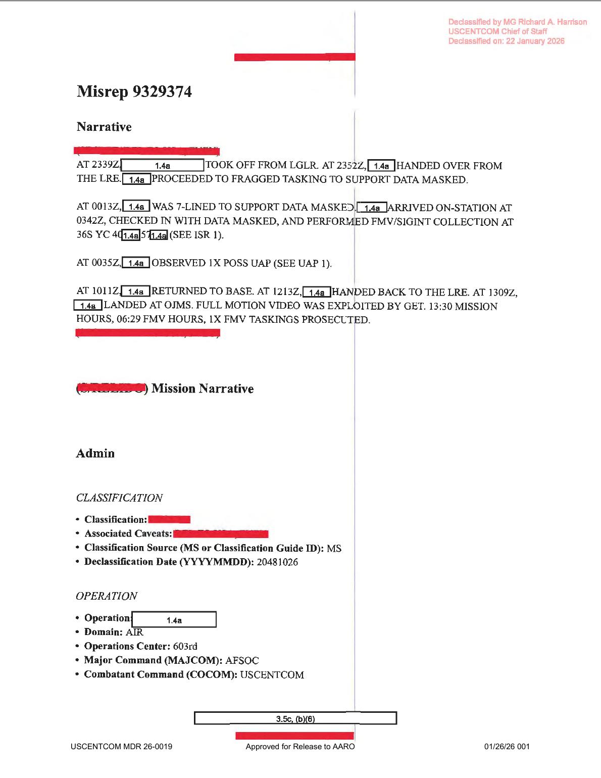 Page 1 places the
 0035Z UAP line inside the broader mission narrative, including takeoff, handover, FMV/SIGINT collection, return, landing, and mission-hour fields.
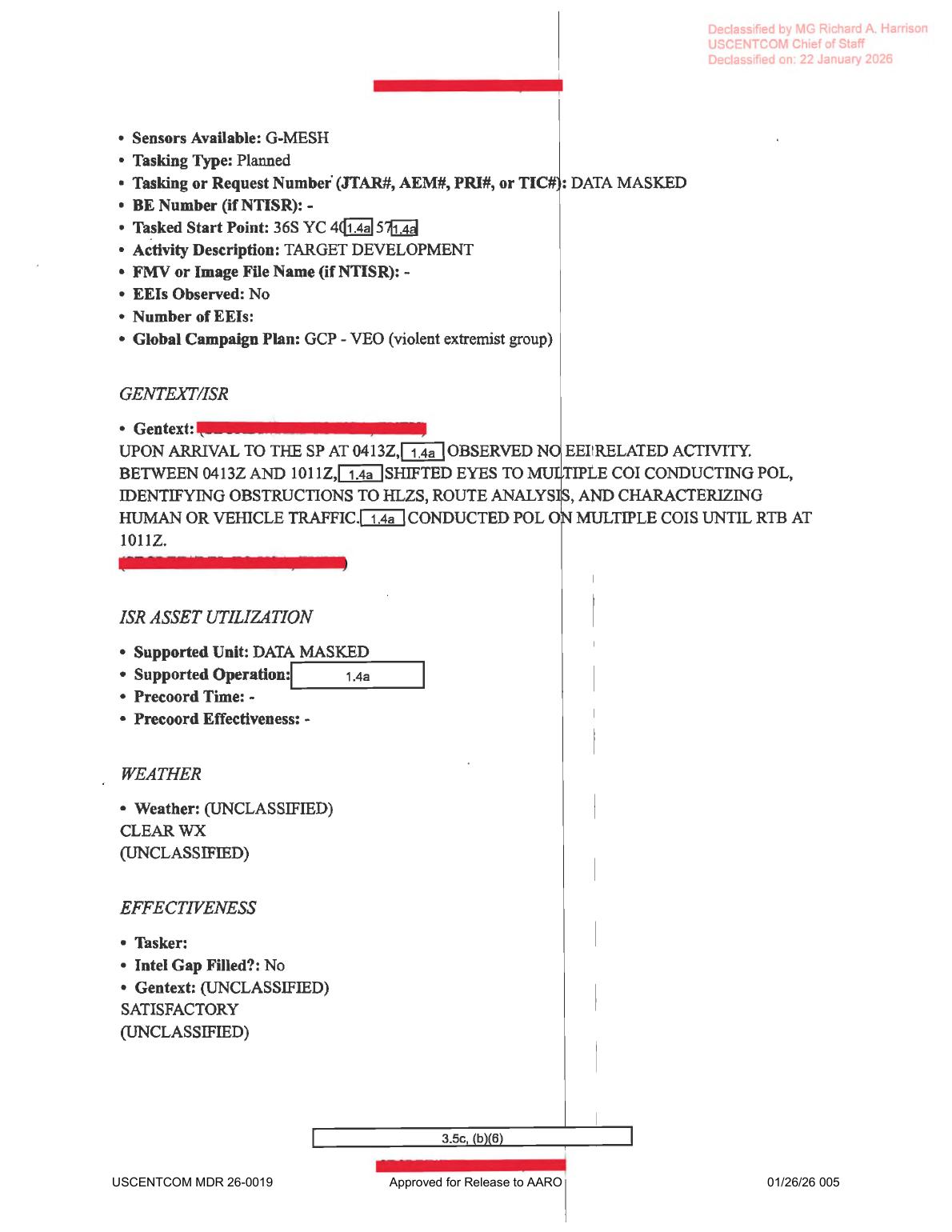 Page 5 shows the ISR support block with
 G-MESH, the partially redacted 36S YC start-point field, target-development activity, clear-weather wording, and SATISFACTORY effectiveness.
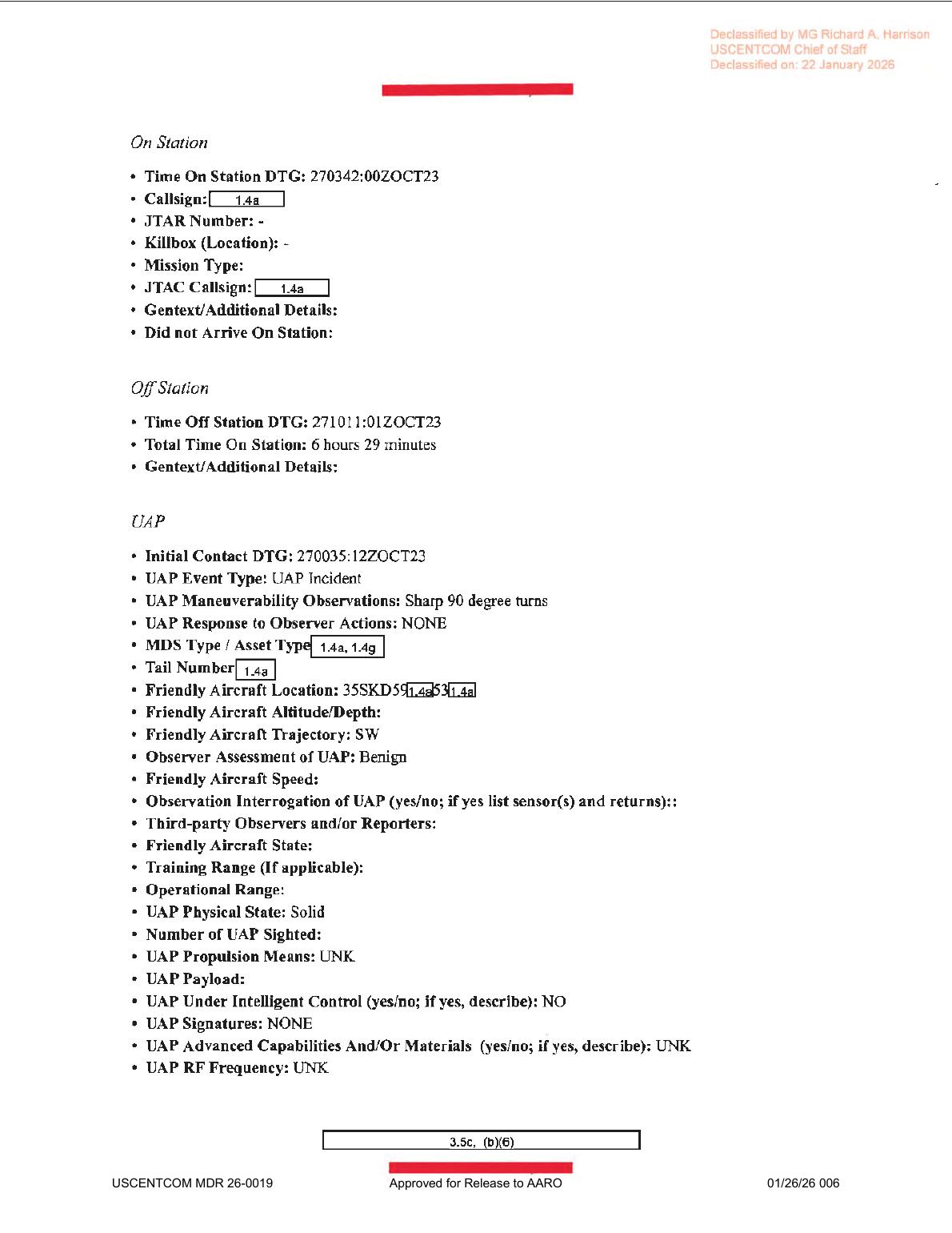 Page 6 starts the UAP form and carries the source entries for
 270035:12ZOCT23, Sharp 90 degree turns, Benign, Solid, NO intelligent control, NONE signatures, and UNK RF frequency.
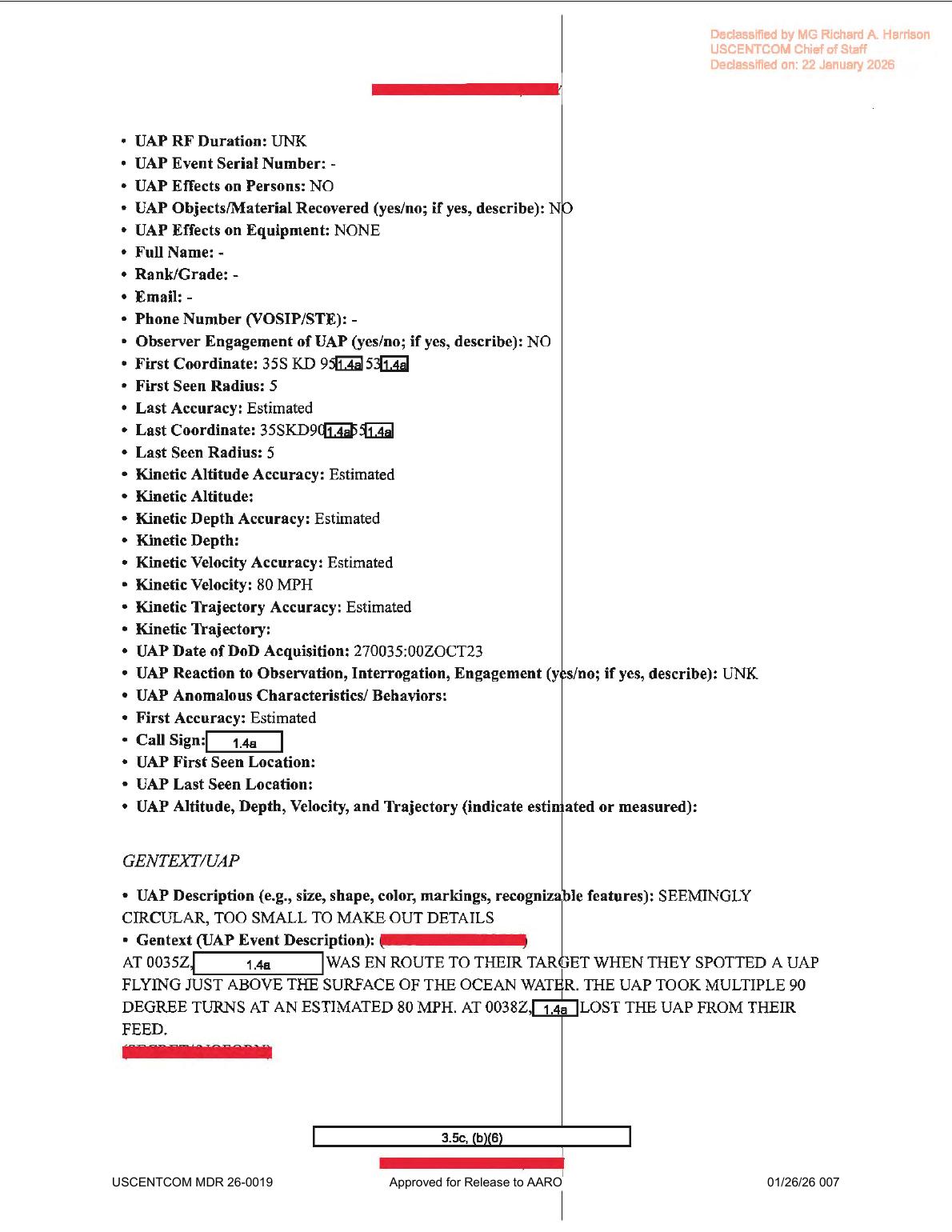 Page 7 contains the partial
 35S KD coordinate fragments, 80 MPH velocity entry, SEEMINGLY CIRCULAR, TOO SMALL TO MAKE OUT DETAILS description, and source-text statement that the feed was lost at 0038Z.
Investigation reading
This is a seven-page USCENTCOM MISREP-style mission report released in WAR.GOV/PURSUE Release 01 and associated in the release metadata with DOW-UAP-PR34 / DVIDS video 1006080. The PDF itself is a text/form packet. A rendered-page pass over all seven pages found no embedded object photograph, map, radar plot, FMV still, sensor frame, chart, or diagram. The useful evidence in this file is therefore the mission narrative, ISR/UAP form fields, redaction pattern, and provenance—not stand-alone imagery.
The high-signal thread is narrow. The report says that at 0035Z on 27 October 2023, while a redacted platform was en route to a target, the crew/reporting party spotted 1X POSS UAP. The UAP section later describes the object as SEEMINGLY CIRCULAR, TOO SMALL TO MAKE OUT DETAILS, flying just above the surface of ocean water, taking multiple 90-degree turns, and moving at an estimated 80 MPH. The rendered page shows the lost-feed time as 0038Z. Those are source statements, not an Open Sky finding.
A key quality-control issue is that the stored OCR/text layer is noisy in several important fields. The rendered page images read 2339Z, 2352Z, 7-LINED, 0342Z, 1309Z, GET, G-MESH, 35S coordinate fragments, 0038Z, and 80 MPH in places where OCR-derived text can misread times, mesh labels, coordinates, or even MPH. Any structured graph update should use the rendered page review before changing canonical fields.
What the file appears to contain
| Page | Public reading |
|---|---|
| 1 | Mission narrative and admin. The rendered page reads: takeoff from LGLR at 2339Z; handover from the LRE at 2352Z; 7-LINED support at 0013Z; on-station/check-in at 0342Z; FMV/SIGINT collection at a partially redacted 36S YC 40...57... grid fragment; AT 0035Z observed 1X POSS UAP; returned to base at 1011Z; handed back to the LRE at 1213Z; landed at OJMS at 1309Z; full-motion video was exploited by GET; 13:30 mission hours and 06:29 FMV hours. |
| 2 | Administrative MSGID/MSNID/POC/QC/approver fields. It identifies a MISREP, 33 SOS originator, ISR mission type, Air Force service tasking, and redacted personnel/contact fields tied to 609 CAOC / 27 SOW / 56 SOIS context. |
| 3 | ACEQUIP/equipment prompts. Radar, RWR, MWS, IRCM, ECM, chaff, flare, towed-decoy, and radar-guided AAM fields are present mostly as blank form prompts. This page should not be read as raw radar or weapons evidence. |
| 4 | Aircraft/equipment and timeline fields. Rendered page reads AN/DAS-4 target pod, AH/GMESH additional avionics, LINK 16, one aircraft, takeoff from LGLR at 262339:00ZOCT23, Mode 3 34055, landing at OJMS at 271309:00ZOCT23, engine shutdown at 271319:00ZOCT23, total mission time 13 hours 30 minutes, ISR time-on station 270342:01ZOCT23, time-off station 271011:00ZOCT23, mission type AREC, and primary sensor FMV. |
| 5 | ISR support page. Rendered page reads sensors available G-MESH, planned tasking, target-development activity, no EEIs observed, clear weather, and SATISFACTORY effectiveness. The GENTEXT/ISR says the platform arrived at the start point at 0413Z, observed no EEI-related activity between 0413Z and 1011Z, shifted to multiple COIs for pattern-of-life/route/traffic characterization, and continued until RTB at 1011Z. |
| 6 | UAP form start. It records time on station 270342:00ZOCT23, off station 271011:01ZOCT23, initial UAP contact 270035:12ZOCT23, event type UAP Incident, maneuverability Sharp 90 degree turns, response to observer actions NONE, friendly-aircraft trajectory SW, observer assessment Benign, physical state Solid, propulsion UNK, intelligent control NO, signatures NONE, advanced capabilities/materials UNK, and RF frequency UNK. The observation-interrogation/sensor-return field is present but not populated. |
| 7 | UAP form continuation and event GENTEXT. It records no effects on persons, no recovered objects/material, no equipment effects, no observer engagement, partial first/last coordinate fragments with five-unit radii and estimated accuracy, kinetic velocity 80 MPH with estimated accuracy, DoD acquisition time 270035:00ZOCT23, reaction UNK, and the description SEEMINGLY CIRCULAR, TOO SMALL TO MAKE OUT DETAILS. The rendered GENTEXT says the platform was en route to target, spotted a UAP just above the ocean surface, the UAP took multiple 90-degree turns at estimated 80 MPH, and the feed was lost at 0038Z. |
Source custody and provenance
- Official/source URL: DOW-UAP-D33, Mission Report, Greece, October 2023
- Open released file: war-gov-dow-uap-d33-mission-report-greece-october-2023-3746998b
- SHA-256:
7078d96f334dbf396e0e0a141f943009fe2191cd20842e16ee381bcbc2776c43 - File size checked:
897,434bytes - PDF page count checked:
7 - Release rows:
48for the D33 PDF record and88for the paired PR34 unresolved UAP report/video record - Release metadata lists incident date
10/27/23and incident locationAegean Sea; the PDF title says Greece, while the PDF body mostly uses redacted MGRS-style coordinate fragments and does not independently spell out a public place name. - Direct automated access to the official media URL returned
403, so this draft relies on the verified Open Sky release-file copy and matching SHA-256 while preserving the official URL as the canonical source.
Graph context
The evidence graph has an exact Document record for the PDF asset and a linked Release 01 record for the official CSV row. The current semantic layer reports 114 extracted claims, 83 entity mentions, 8 sensor-event records, and no table rows for this asset. Treat those graph facts as navigation aids for review, not as adjudicated conclusions.
The graph sensor events correctly surface FMV/SIGINT and FMV mission context, but some apparent radar/IR/platform hits are caused by standard MISREP form prompts or aircraft equipment fields. Page 3 lists radar/RWR/MWS/IRCM/ECM prompts without populated returns. Page 4 lists an AN/DAS-4 target pod and LINK 16, but the PDF does not include a sensor image or raw return. Page 6 leaves the observation-interrogation/sensor-return field blank, and page 7 records UAP Signatures: NONE / UAP RF Frequency: UNK.
The graph also connects this PDF to DOW-UAP-PR34 / DVIDS video 1006080, which the release description says contains two minutes and fifty-seven seconds of infrared video. That paired video is a separate source item. This PDF page should not be used as a substitute for direct video review.
Candidate crosslinks and related Release 01 records should remain review leads only. Shared terms, neighboring row context, or release-batch associations do not establish that another case corroborates this event.
Leads to check
- Compare the rendered-page corrections against the graph/OCR fields before any structured cleanup: page 1 timing (
2339Z,2352Z,0342Z,1309Z),7-LINED,GET; page 5G-MESH; page 735Scoordinate fragments,0038Z, and80 MPH. - Review the paired PR34/DVIDS video
1006080directly and then compare video timestamp behavior, contrast-filter/reticle behavior, platform motion, and lost-lock timing against the MISREP text. - Because the reported feature was near the ocean surface, check prosaic correlation lanes before escalation: sea-surface traffic, wakes, birds, wind/wave contrast, sensor stabilization, sensor-track/reticle behavior, platform parallax, and local weather/visibility.
- Reconcile the release metadata location (
Aegean Sea/ Greece) with the redacted MGRS fragments in the PDF and any unredacted metadata in the paired video record. - Preserve the source-level limits around
Observer Assessment of UAP: Benign, blank sensor-return fields,UAP Signatures: NONE, andRF Frequency: UNK; those entries matter because they narrow what the PDF actually supports.
Lead check notes
- Checked — source-text/OCR cleanup anchors: Page renders and selectable PDF text support the core correction set: page 1
2339Z,2352Z,7-LINED,0342Z,1309Z, andGET; page 5G-MESH; page 6270035:12ZOCT23; and page 735S KDcoordinate fragments,270035:00ZOCT23,0038Z, and80 MPH. Stored OCR variants should be treated as extraction-quality issues, not alternate source values. - Partial — PR34 video pairing: The paired PR34 / DVIDS
1006080release-file copy is present and hash-verified, and the release description ties it to D33 with a 2:57 infrared video timeline. Direct frame-level review is still needed before matching the description's contrast-filter, reticle, lost-lock, platform-motion, or timestamp behavior to the MISREP wording. - Needs external source — sea-surface prosaic checks: The PDF and release description identify a near-ocean-surface report but do not provide unredacted geometry, sensor settings, platform track, weather observations, maritime/air traffic, astronomy, satellite, launch, or reentry data. Those checks remain open until the paired video and external context are reviewed.
- Partial — location reconciliation: Release metadata says Aegean Sea / Greece; the PDF body preserves only redacted MGRS-style fragments, including
36S YCon the ISR tasking page and35S KDon the UAP continuation page. The current sources do not expose enough unredacted location detail to resolve exact geography. - Checked — source-level limits: Page 6 and page 7 preserve
Observer Assessment of UAP: Benign, a blank observation-interrogation/sensor-return field,UAP Signatures: NONE,UAP RF Frequency: UNK, no effects on people/equipment, no recovered material, and no observer engagement. These are report fields, not an object identification or event resolution.
Limits
This draft does not resolve the event, identify the object, or assert a hypothesis. It records what the released PDF appears to say after page-level review.
The PDF is a redacted text/form packet, not a visual-evidence packet. It does not show the object, a map, a radar display, an FMV frame, or an instrument plot. Several high-signal fields are redacted or blank, including full coordinates, platform identity, altitude/depth/trajectory detail, and any populated sensor-return explanation.
OCR is useful for discovery but unreliable on this document. The rendered page images correct or question multiple OCR-derived fields, so any downstream graph cleanup should cite the page image rather than the rough OCR alone.
Deep investigation — graph + web reconnaissance
Source reread and paired-media alignment
The verified release-file PDF remains the controlling source for the D33 report: seven pages, 897,434 bytes, SHA-256 7078d96f334dbf396e0e0a141f943009fe2191cd20842e16ee381bcbc2776c43, PDF title DOW-UAP-D33, Mission Report, Greece, October 2023, and a WAR.GOV canonical URL at https://www.war.gov/medialink/ufo/release_1/dow-uap-d33-mission-report-greece-october-2023.pdf. A fresh page-render check confirms that page 6 carries the source form entries 270035:12ZOCT23, Sharp 90 degree turns, Benign, Solid, UAP Signatures: NONE, UAP RF Frequency: UNK, and UAP Under Intelligent Control: NO, while the observation/interrogation/sensor-return field is present but blank. Page 7 reads as a partially redacted 35S KD coordinate fragment, 80 MPH, 270035:00ZOCT23, and the description SEEMINGLY CIRCULAR, TOO SMALL TO MAKE OUT DETAILS; the narrative says the report party saw the object just above ocean water at 0035Z and lost it from the feed at 0038Z. OCR remains useful for search, but it is not authoritative here: the rendered pages correct OCR-sensitive values such as 35S KD, 80 MPH, and 0038Z.
The paired PR34 source is the official DVIDS video page https://www.dvidshub.net/video/1006080/dow-uap-pr34-unresolved-uap-report-greece-october-2023 plus the verified Open Sky MP4 copy, 198,248,609 bytes, SHA-256 34eb85ab42bb6ce5d376c02fd2db4eee0211864ed3bcd8a8247a08fe0da8c99e. Local media metadata reads as H.264 video, 1920×1080, 30 fps, and 177.2 seconds. The derived PR34 contact sheets support a cautious video reading: a faint low-contrast feature or darker patch is visible in the sensor-field crops, while black masks, cyan/teal reticles, tracking marks, contrast/filter behavior, compression, and sparse frame sampling make the contact sheets unsuitable for measuring size, range, speed, altitude, trajectory, or cause. The D33 PDF supplies the source report language; PR34 supplies the released visual context. Neither source alone resolves the event.
Graph connections and provenance-audit notes
The evidence graph has an exact official-primary Document node for the D33 PDF asset with the matching URL/hash, 11 linked text chunks, 114 machine-extracted claims, and 8 machine-extracted sensor-event records. It also has an official-primary VideoEvidence node for DVIDS 1006080 with 22 machine-extracted claims and two description chunks. Those graph records are useful navigation aids, not findings: the relevant claim and sensor-event nodes remain machine_extracted_needs_human_review / not_a_finding, and some sensor hits come from MISREP form prompts or equipment fields rather than populated sensor returns.
A provenance cleanup issue is visible at the row layer. The exact D33 asset correctly carries related CSV rows 48 and 88, but row-level graph relations also surface stale or cross-row neighbors, including D4/PR37 and an older D32/PR31 trail caused by current-CSV reconciliation history. Candidate crosslinks generated from that stale row text point to Syria/CIA/AMS-style audit leads and should not be treated as D33 corroboration. For this page, the reliable local relation is the D33 PDF asset paired with PR34 / DVIDS 1006080; the rest is a graph-stewardship lead.
External official context and prosaic checks
Direct automated fetches of the WAR.GOV PDF and official CSV returned 403 Forbidden during this check, while the DVIDS PR34 page returned 200 and confirms the public title, video ID 1006080, filename DOD_111689011, length 00:02:57, location code GR, date posted 05.08.2026 07:48, date taken 10.01.2023, and VIRIN 231002-D-D0360-6858. That DVIDS date/VIRIN metadata does not line up cleanly with the D33 report's 27 OCT 2023 event fields, so it should be handled as a source-provenance tension until reconciled against the release CSV and any additional official metadata. The DVIDS description is also explicitly cautious: it describes an area of contrast, reticle/contrast-filter behavior, and lock loss, and says the description should not be read as an analytical judgment or factual determination.
The only environmental statement in the PDF is the page-5 CLEAR WX field. Public data still lacks unredacted coordinates, platform track, range, sensor calibration, field of view, sea state, maritime traffic, local aviation traffic, satellite/launch/reentry geometry, and exact weather/visibility at the target line of sight. That blocks any serious astronomy, weather, satellite, aircraft, ship, wake, bird, glare, or parallax correlation. The first prosaic lanes remain sensor/display processing, platform/sensor motion, sea-surface contrast or wakes, birds, small craft, compression artifacts, and redaction/masking effects.
Limits and next checks
This deep check does not identify the object or assert a finding. The public record now supports a tighter statement: D33 is a redacted source-report packet with a paired official MP4, not a resolved event dossier. The next high-value checks are to reconcile the D33/PR34 row/date metadata, review continuous PR34 frames around the DVIDS 00:04, 00:07–00:19, 02:02–02:22, and 02:27–02:57 windows, and keep any future environmental correlation explicitly blocked until better location/platform geometry is available.
Sources
- Department of War / WAR.GOV PURSUE Release 01:
DOW-UAP-D33, Mission Report, Greece, October 2023, official URL above. - Open Sky verified release-file copy for this slug, SHA-256
7078d96f334dbf396e0e0a141f943009fe2191cd20842e16ee381bcbc2776c43. - Paired video source: DOW-UAP-PR34 / DVIDS 1006080, with Open Sky release-file copy war-gov-dow-uap-pr34-unresolved-uap-report-greece-october-2023-1006080.
- Release 01 CSV metadata rows
48and88, linking this PDF to DOW-UAP-PR34 / DVIDS video1006080.