DOW-UAP-D38, Range Fouler Debrief, Middle East, May 2020
Evidence media
- Open Sky release-file copy of the official D38 PDF — verified as a 342,668-byte, one-page PDF with SHA-256
90b353682ba2181149054d0911b7553e58e959438dd4de531a06fc387a332f85. - Paired Release 01 video record: PR36 / DVIDS 1006083 — verified as a 142,686,223-byte MP4 with SHA-256
5f32ce0126de2c9571f2af368b2629c15b4f1cb3582700641ef31c1d1a8ceac8. The release description ties the video to D38 and describes a two-minute-and-seventeen-second infrared clip; detailed frame/timestamp review remains a separate check.
Derived page render from the official PDF is included below for source-document orientation. It is a page render from the PDF, not standalone object imagery.
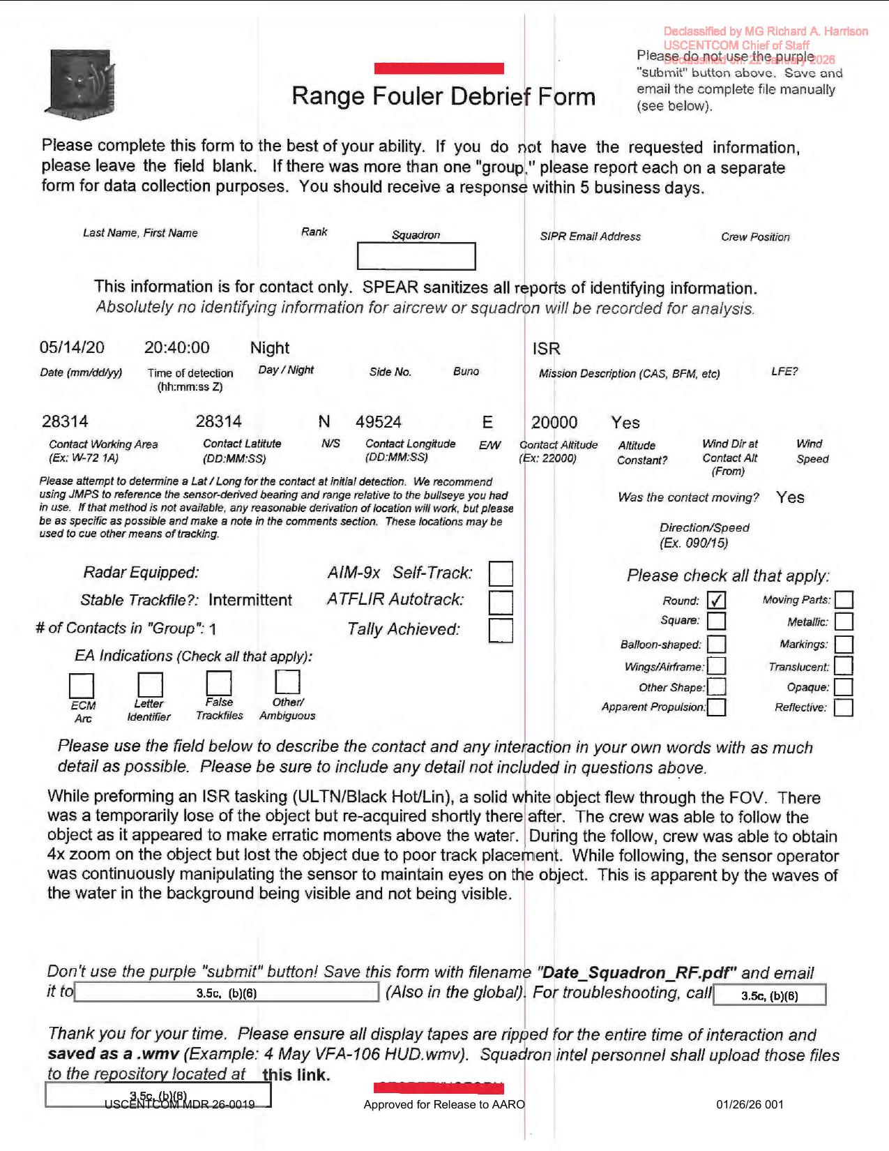 Page 1 shows the Range Fouler Debrief form fields, including
 05/14/20, 20:40:00, Night, ISR, Stable Trackfile?: Intermittent, one round contact, and the narrative describing a solid white object above water. The render is useful because several small fields differ from rough OCR, especially the zoom level and declassification stamp.
Investigation reading
This is a one-page Range Fouler Debrief form tied in the Release 01 metadata to the May 14, 2020 Middle East / Arabian Gulf event and the related PR36 video record. The PDF itself is not a video frame packet: it is a scanned form with typed fields, a short free-text narrative, release markings, and redactions. This draft compares the stored OCR, the selectable PDF text layer, and a rendered-page visual check because the OCR/text layer disagree on several high-signal words.
The core source statement is narrow. A crew member reported that, while performing an ISR tasking described as ULTN/Black Hot/Lin, a solid white object passed through the sensor field of view. The form says the object was temporarily lost and then reacquired; the crew followed it above the water; the sensor operator had to keep manipulating the sensor to maintain eyes on it; and the object was ultimately lost because of poor track placement. The rendered page reads 4x zoom; the stored OCR currently reads 2x zoom. The rendered page also appears to read erratic moments, while the official release description normalizes this to erratic movements. Those differences should be treated as source/OCR quality-control leads, not as separate claims.
Nothing in this PDF resolves what the object was. The form is evidence that a range-fouler-style report was submitted, that one contact was described, and that a paired video record exists elsewhere in the release set. It does not include embedded still imagery, a radar plot, a raw sensor frame, or a technical exploitation report.
What the file appears to contain
| Field | Reading from the rendered source page |
|---|---|
| Form type | Range Fouler Debrief Form |
| Declassification marking | Rendered page favors Declassified by MG Richard A. Harrison, USCENTCOM Chief of Staff, and a January 2026 declassification line, likely 22 January 2026; exact date remains a transcription check because the stamp overlaps other text |
| Date / time | 05/14/20, 20:40:00 Z, Night |
| Mission description | ISR |
| Location fields | Contact working area 28314; latitude/longitude fields appear as 28314 N and 49524 E as printed/OCR-collapsed on the form; punctuation/coordinate format needs human verification |
| Altitude fields | Contact altitude 20000; altitude constant Yes; wind fields blank |
| Moving contact | Was the contact moving? Yes; direction/speed field blank |
| Tracking / aircraft fields | Stable Trackfile?: Intermittent; AIM-9x Self-Track, ATFLIR Autotrack, and Tally Achieved appear unchecked |
| Contact count / shape | # of Contacts in "Group": 1; Round checked; moving parts, square, metallic, balloon-shaped, markings, wings/airframe, translucent, other shape, opaque, apparent propulsion, and reflective appear unchecked |
| EA / false-track prompts | ECM arc, letter identifier, false trackfiles, and other/ambiguous boxes appear unchecked |
| Narrative | Solid white object flew through the FOV during ISR; temporarily lost and reacquired; followed above water; zoom obtained; lost because of poor track placement; sensor manipulation is visible in changing wave visibility |
| Footer | USCENTCOM MDR 26-0019; Approved for Release to AARO; 01/26/26 001 |
The PDF is a scanned, image-heavy one-page document with a selectable text layer. A rendered-page check is important here because the selectable text and OCR misread or normalize several fields: the declassification stamp, some form wording, the zoom level, and moments/movements in the narrative.
Source custody and provenance
The official file is a Department of War Release 01 PDF at the WAR.GOV media URL preserved in the source record. The Open Sky release-file copy was checked against the release metadata hash:
- SHA-256:
90b353682ba2181149054d0911b7553e58e959438dd4de531a06fc387a332f85 - Size:
342,668bytes - PDF page count:
1 - Source/container type: PDF, scanned form with page-image content and selectable text
- Official CSV rows:
50and90 - Related video record noted by the release metadata:
DOW-UAP-PR36, DVIDS video ID1006083
The direct PDF page supplies the debrief text. The release metadata supplies the paired-video context and a time-coded official description of the PR36 video, including a two-minute-and-seventeen-second infrared sensor clip and moments where an area of contrast enters, re-enters, remains in view, is zoomed on, and is then lost after a modality switch. That video should remain a separate review item unless its own source file is inspected.
Graph context
The graph currently has an official primary Document node for this PDF asset and an official Release 01 record node for the row-level entry. The asset is modeled with 50 extracted claim records, 24 entity mentions, one extracted sensor-event record, and no extracted table rows. Those graph facts are useful navigation, but the source page should be read before treating any extracted field as evidence.
The most important graph caution is the single RADAR sensor-event extraction. The rendered form shows Radar Equipped as a prompt area, while the visible populated tracking fields are Stable Trackfile?: Intermittent, one contact, and unchecked self-track/autotrack/tally boxes. The PDF does not show a raw radar return, radar plot, scope image, or populated radar narrative. That graph sensor event should therefore be reviewed as a form-label extraction rather than as proof of radar data.
The graph also lists related Release 01 records for the paired PR36 video and nearby range-fouler / mission-report items. Candidate crosslinks to older CIA or prosaic-correlation records appear to be broad anchor matches, not case-level corroboration, and need manual review before use.
Leads to check
- Inspect the paired PR36 / DVIDS
1006083video record separately and compare the official time-coded video description with the debrief'ssolid white object, tracking-loss, zoom, and water-background language. - Verify the coordinate formatting on the original page image. The visible fields read like
28314 Nand49524 E, but the form labels imply a DD:MM:SS-style entry and the punctuation may be lost in OCR/rendering. - Resolve text discrepancies: rendered page
4x zoomversus stored OCR2x zoom; renderederratic momentsversus release-descriptionerratic movements; declassification stamp text/date differences between OCR and rendered page. - Check whether
ULTN/Black Hot/Linis a sensor-mode shorthand, a transcription artifact, or a redacted/abbreviated mission display phrase. - Review whether the
Intermittentstable-trackfile field has any associated raw display tape or .wmv repository material in the paired release media. - Keep the
Radar Equippedgraph extraction under review; the source page does not by itself show a radar measurement or raw radar evidence.
Lead check notes
- Partial — PR36 video pairing: The paired PR36 / DVIDS
1006083release-file copy is present and hash-verified, and the release description ties it to D38 with a two-minute-and-seventeen-second infrared sequence: contrast entering at00:05, re-entering at00:19, remaining generally in view through01:15, zoom events at01:16and01:56, a brief blue reticle at02:10, and loss after a modality switch at02:15-02:17. That supports the source-level pairing, but direct frame-by-frame comparison with the debrief'ssolid white object, water-background, zoom, and track-loss wording remains open. - Partial — coordinate formatting: The rendered PDF page and OCR both expose
28314in the working-area/latitude fields and49524 Ein the longitude field, but the form label expects aDD MM.SSstyle coordinate entry. The released page does not preserve enough punctuation or unredacted context to publish an exact public geolocation. - Checked — text/OCR discrepancy anchors: Visual inspection of the page render favors
4x zoomand the unusual phraseerratic moments above the water, while the stored OCR has2x zoomanderratic movements. The declassification stamp also conflicts with rough OCR; the render favorsMG Richard A. Harrison,USCENTCOM Chief of Staff, and a January 2026 date. These should stay as transcription-quality leads unless a cleaner source copy is checked. - Needs external source —
ULTN/Black Hot/Lin: Searching the current linked Release 01 OCR corpus found the exactULTN/Black Hot/Lin,solid white object,28314, and49524anchors confined to this D38 file. A sensor-mode glossary, cockpit/display documentation, or direct PR36 frame review is needed before expanding that shorthand in public prose. - Blocked — display-tape /
.wmvrepository trail: The form instructs squadrons to preserve display tapes as.wmvfiles, and similar boilerplate appears in multiple Release 01 range-fouler forms, but this D38 release package exposes the PDF and paired PR36 MP4 rather than a raw display-tape repository file. Any claim about original display-tape handling needs a separate source. - Checked — radar/track caution: The source page shows
Radar Equippedas a form prompt area plusStable Trackfile?: Intermittent, one contact, and unchecked self-track/autotrack/tally boxes. It does not include a radar plot, raw radar measurement, populated radar narrative, or independent radar return, so the graphRADARextraction should remain a form-label review item.
Limits
This page is an investigation draft for source reading only. It does not identify the object, assess performance, or decide whether the report is anomalous. The debrief is a single-page form with redacted contact information and no embedded images, maps, radar plots, instrument screenshots, or lab analysis. The paired video is referenced by the release metadata but is not contained inside this PDF. Official release language also cautions that descriptive and estimative wording reflects the reporter's interpretation at the time rather than an analytical conclusion.
Deep investigation — graph + web reconnaissance
Source reread
The source-file reread confirms the cached official PDF is the same one-page D38 Range Fouler Debrief represented in the release metadata: 342,668 bytes, SHA-256 90b353682ba2181149054d0911b7553e58e959438dd4de531a06fc387a332f85, PDF title/subject DOW-UAP-D38, Range Fouler Debrief, Middle East, May 2020, and a Paper Capture text layer. The PDF is copy-restricted, so the safest reading is the combination of rendered page, selectable text layer, and OCR.
The populated source fields remain narrow: 05/14/20, 20:40:00Z, Night, mission ISR, working area/latitude printed as 28314, longitude as 49524 E, contact altitude 20000, altitude constant Yes, contact moving Yes, Stable Trackfile?: Intermittent, one contact, and Round checked. The form does not expose a clean public geolocation; the coordinate labels imply a degree/minute/second-style format, but the released scan collapses punctuation and should not be converted into a precise location without a cleaner source.
The narrative should be quoted cautiously. The rendered page favors: While performing an ISR tasking (ULTN/Black Hot/Lin), a solid white object flew through the FOV; temporary loss and reacquisition; the object appearing to make erratic moments above the water; 4x zoom; loss because of poor track placement; and continuous sensor manipulation visible through changing wave/background visibility. The stored OCR and release prose normalize parts of this language, including 2x zoom in OCR and erratic movements in the release/DVIDS description. Those are transcription/provenance issues, not separate observations.
The source page also does not by itself prove radar data. Radar Equipped appears as a form prompt area without a visible populated value; AIM-9x self-track, ATFLIR autotrack, tally achieved, EA indications, and most appearance boxes appear unchecked. The only populated tracking field is Stable Trackfile?: Intermittent, so any graph RADAR extraction should remain a machine-review flag rather than evidence of a radar return.
Paired PR36 video and official web context
The paired official DVIDS page for DOW-UAP-PR36, Unresolved UAP Report, Middle East, May 2020 was reachable during this check at https://www.dvidshub.net/video/1006083/dow-uap-pr36-unresolved-uap-report-middle-east-may-2020. DVIDS lists video ID 1006083, filename DOD_111689030, VIRIN 200502-D-D0360-5343, category B-Roll, length 00:02:17, date taken 05.01.2020, date posted 05.08.2026 07:48, and location (UNDISCLOSED LOCATION). Its description explicitly pairs PR36 with DoW-UAP-D38 and repeats the official caution that the video description is informational, not an analytical judgment or factual determination about the event's validity, nature, or significance.
The local release-file copy of PR36 verifies as a 142,686,223 byte MP4 with SHA-256 5f32ce0126de2c9571f2af368b2629c15b4f1cb3582700641ef31c1d1a8ceac8. Media metadata reads as H.264 video, 1920×1080, 30 fps, about 137.37 seconds, with AAC stereo audio. Representative frames at the publisher-described anchors show a heavily masked monochrome sensor/HUD feed, green reticle/bracket symbology, colored interface marks, and a changing scene/display state. The clearest unresolved contrast feature is an irregular dark/bright cluster near the early 00:05 sample; later samples show small unresolved specks or diffuse contrast near symbology, and the final sample is mostly black scene field with symbology still visible after the described modality/display change. The public MP4 supports source-level pairing and display-state review, but not range, size, altitude, speed, identity, or independent-motion conclusions.
Direct probes of the WAR.GOV media URL, release landing page, press-release page, and CSV URL returned 403 Forbidden during this check. That does not weaken the cached file copy because Open Sky already preserves the official URL, official-source metadata, prior successful WAR.GOV/CSV provenance, byte count, and hash; it does mean current direct WAR.GOV web access should be treated as a source-availability caveat rather than a content change.
Graph connections and provenance cautions
Read-only graph review finds an official-primary Document node for the D38 PDF asset with the same canonical URL, byte count, SHA-256, OCR status, release label, and related CSV rows 50 and 90. It has six TextChunk neighbors spanning manifest text, current CSV/description text, and frontier OCR text; fifty Claim neighbors; one SensorEvent neighbor; one official Source; four related row/document records; and one derived secondary markdown conversion. The extracted claims are still marked machine_extracted_needs_human_review and not_a_finding, with common buckets such as observation, witness-testimony, document-identity, agency, motion, time, location, redaction, and sensor. They are navigation aids, not conclusions.
The single SensorEvent is sensor_modality: RADAR, but its source quote is the form area around Was the contact moving?, Radar Equipped, Stable Trackfile?: Intermittent, and unchecked self-track/autotrack boxes. That matches the source-reading caution above: this is a form-label extraction needing review, not an independent radar plot or track.
The direct graph neighborhood links D38 to the release-row record for CSV row 50, the PR36 row record at row 90, the PR36 VideoEvidence record, and nearby records carrying row/hash/video-ID tensions: D44 row 53 and PR39 row 93 surface in the same neighborhood because of current-manifest reconciliation and duplicated pairing/hash anchors. Those links should be handled as provenance-cleanup leads, not as evidence that D38, D44, PR36, and PR39 describe the same incident.
Prosaic checks, blockers, and follow-up leads
The first prosaic lane is sensor/display handling: black-hot contrast, gain/contrast cycling, zoom, field-of-view changes, masking/redaction, compression, reticle/symbology overlap, and the final modality/display switch can all affect how a small contrast area appears in public MP4 frames. The debrief itself says sensor manipulation changed the visibility of waves/water in the background, which makes sea-surface contrast, whitecaps, glint, foam, birds, debris, distant traffic, and platform/sensor motion all necessary checks before escalation.
A bounded graph date/location probe did not surface a separate same-date astronomy, weather, or launch correlation record tied to this event. That is not a negative finding: the released public record lacks reliable unredacted coordinates, line of sight, platform position, sensor model/settings, field of view, sea state, weather, traffic picture, and satellite/aircraft/flare context. The DVIDS Date Taken value (05.01.2020) also does not match the D38 form date (05/14/20), so date provenance needs reconciliation before time-sensitive environmental checks are meaningful.
Audit note
This deep-investigation section adds graph/web/source context only. It does not identify the object, resolve the report, create a finding, or promote a hypothesis. The current evidence supports an official-source chain for a D38 one-page debrief and a paired PR36 public MP4, plus a list of transcription, provenance, graph-cleanup, and prosaic-correlation tasks that must be resolved before any stronger claim is made.
Sources
- Official WAR.GOV PDF: DOW-UAP-D38, Range Fouler Debrief, Middle East, May 2020
- Open Sky release-file view: war-gov-dow-uap-d38-range-fouler-debrief-middle-east-may-2020-88a20bf2
- Release 01 source metadata: Department of War PURSUE Release 01 CSV rows
50and90 - Related paired video record cited by the release metadata: DOW-UAP-PR36 / DVIDS video ID
1006083, with Open Sky release-file copy war-gov-dow-uap-pr36-unresolved-uap-report-middle-east-may-2020-1006083, SHA-2565f32ce0126de2c9571f2af368b2629c15b4f1cb3582700641ef31c1d1a8ceac8.