DOW-UAP-D44, Range Fouler Reporting Form, Gulf of Aden, October 2020
Evidence media
- Open Sky release-file copy of the official D44 PDF — verified as a 297,873-byte, one-page PDF with SHA-256
c5cfbc8bacca29db64346aaa03846a6e36eab01ac09e1e93d8d50028593cf3f9.
Derived page render from the official PDF is included below for source-document orientation. It is a page render from the PDF, not standalone object imagery.
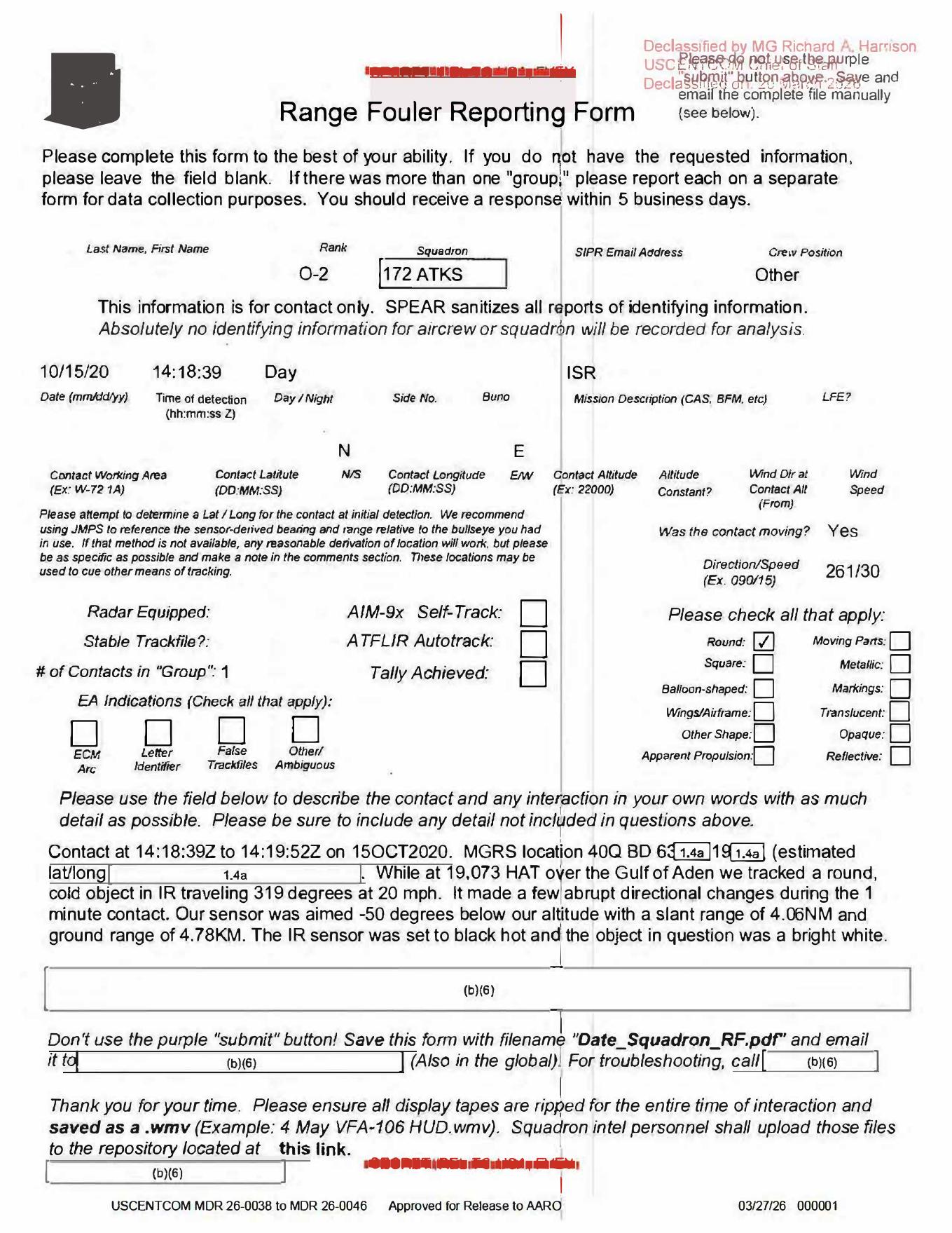 Page 1 shows the Range Fouler Reporting Form fields, including
 10/15/20, 14:18:39, ISR, moving contact Yes, direction/speed field 261/30, one round contact, and the narrative describing an IR-tracked contact over the Gulf of Aden. The render is useful because small source fields are easy to misread in OCR: the narrative direction/speed reads 319 degrees at 20 mph, the slant range visually favors 4.06NM, and the ground range reads 4.78KM. The PDF contains form text and checkboxes only; it does not include an object photograph, video frame, map, or radar plot.
Investigation reading
This release item is a one-page Range Fouler Reporting Form for an October 15, 2020 contact. It is not an image packet: the released PDF page contains a filled form and a narrative field, with no embedded object photograph, no radar plot, no map, and no sensor-frame still. The strongest source-backed reading is a short ISR observation report: one contact, described on the form as round, observed in infrared, with a roughly one-minute narrative contact window from 14:18:39Z to 14:19:52Z on 15OCT2020.
The page should be handled as documentary evidence for what the reporting operator wrote, not as independent visual proof of an object. The form records mission context, some checkboxes, a partly redacted location, and a short narrative. It also instructs personnel to preserve display tapes as .wmv files, but this PDF does not include those tapes or a still from them.
What the file appears to contain
The rendered page is headed Range Fouler Reporting Form. Administrative release markings at the bottom read USCENTCOM MDR 26-0038 to MDR 26-0046, Approved for Release to AARO, and 03/27/26 000001. Identifying contact details are blank or redacted, consistent with the form text saying SPEAR sanitizes reports of aircrew and squadron identifying information.
Visible filled fields include:
| Field | Reading from the released page |
|---|---|
| Date | 10/15/20 |
| Time of detection | 14:18:39 |
| Day/night | Day |
| Mission description | ISR |
| Rank / squadron / crew position | O-2, 172 ATKS, Other |
| Was the contact moving? | Yes |
| Direction/speed form field | 261/30 |
| Number of contacts in group | 1 |
| Shape checkbox | Round checked |
| AIM-9x self-track / ATFLIR autotrack / tally / EA checkboxes | appear blank or unchecked on the rendered page |
The narrative field is the main evidentiary text. It states that contact ran from 14:18:39Z to 14:19:52Z on 15OCT2020. The MGRS and estimated latitude/longitude are partly withheld under visible redaction markings. The readable narrative says the platform was at 19,073 HAT over the Gulf of Aden and tracked a round, cold object in IR traveling 319 degrees at 20 mph. It says the contact made a few abrupt directional changes during the one-minute contact. The sensor geometry line gives a sensor depression angle of -50 degrees, a slant range that the rendered page appears to read as 4.06NM, and a ground range of 4.78KM. The stored OCR has 4.05NM; that small OCR/render discrepancy should be checked against the original before using the exact number analytically. The final sentence says the IR sensor was set to black-hot polarity and that the object in question appeared bright white.
Two internal tensions are important. First, the structured direction/speed field reads 261/30, while the narrative reads 319 degrees at 20 mph. Second, the release title uses Gulf of Aden, the PDF URL and PDF metadata use Arabian Sea, and the release record lists the incident location as Arabian Sea; the narrative itself says over the Gulf of Aden. These may be adjacent regional labels or release-row normalization differences, but they should not be silently collapsed.
Source custody and provenance
The source is an official Release 01 PDF asset from the Department of War / WAR.GOV PURSUE release. The official source URL is:
https://www.war.gov/medialink/ufo/release_1/dow-uap-d44-range-fouler-arabian-sea-october-2020.pdf
The Open Sky release-file route is:
The Open Sky release-file copy was verified as 297,873 bytes with SHA-256:
c5cfbc8bacca29db64346aaa03846a6e36eab01ac09e1e93d8d50028593cf3f9
The PDF reports one page. OCR coverage is complete for the single page, and the rendered page was checked visually because the text layer is noisy around redactions, checkboxes, and overprinted release markings. A direct byte-range probe of the official WAR.GOV URL returned the same one-page PDF length, so the official endpoint and the Open Sky release-file copy agree on size for this asset.
Graph context
The graph currently models this item as an official primary Document asset linked to release metadata row 53. Current WAR.GOV CSV excerpts also surface the same D44 title/PDF under row 56; those row-number references should be treated as release-metadata cleanup until reconciled. The row-level release record reports incident date 10/15/20 and incident location Arabian Sea, while the asset title and narrative preserve the Gulf of Aden wording. The semantic layer has 35 extracted claims, 19 entity mentions, and 3 sensor-event records.
Those graph records are useful navigation cues, but they should be read carefully. The two IR sensor records are grounded in the narrative lines about tracking the contact in IR and black-hot polarity. The RADAR sensor-event record appears to come from a form label near Radar Equipped, not from a populated radar return, radar plot, or radar narrative in this PDF. The released page itself does not show radar data.
The graph also carries a relationship to DVIDS video 1006083, titled DOW-UAP-PR36, Unresolved UAP Report, Middle East, May 2020, and to nearby Range Fouler / Arabian Gulf release records. That relation should be treated as a provenance-cleanup lead for now. This D44 PDF is an October 2020 text form and does not itself contain the PR36 video, a still from that video, or a clear pairing statement on the page.
Leads to check
- Reconcile the direction/speed mismatch: the form field reads
261/30, while the narrative says319 degrees at 20 mph. - Verify the exact slant-range value from the highest-quality source image: rendered page appears to read
4.06NM, while stored OCR has4.05NM. - Reconcile location labels across the title, URL/PDF metadata, release row, and narrative:
Gulf of AdenversusArabian Sea. - Determine whether any
.wmvdisplay tape referenced by the form was actually released, withheld, or separately represented by a DVIDS record. - Review whether DVIDS
1006083is truly associated with D44 or whether it belongs only to another Release 01 Range Fouler item. - Check weather, maritime traffic, aircraft tracks, satellite/launch context, and ISR platform geometry for the one-minute window before escalating any interpretation.
- Treat the black-hot / bright-white / cold-object wording as a sensor-polarity reading to verify, not as a standalone physical conclusion.
Lead check notes
- Checked — direction/speed mismatch: The OCR text and rendered page both preserve the structured form field as
261/30, while the narrative line reads319 degrees at 20 mph. The released PDF does not include a track file, map, video frame, or sensor log that would resolve whether those are different reference fields, later narrative refinement, or a reporting inconsistency. - Checked — slant-range transcription: The stored OCR reads
4.05NM, but visual review of the page render favors4.06NM; the same line clearly gives a ground range of4.78KM. Treat the exact slant-range digit as a source-image transcription lead until a cleaner original is checked. - Partial — location labels: The rendered narrative says the platform was
over the Gulf of Adenand gives a partly redacted MGRS string beginning40Q BD, while the release title/URL/metadata also useArabian Sea. Without the unredacted coordinate or platform geometry, those regional labels should remain visible provenance tension rather than a resolved location correction. - Blocked — display-tape /
.wmvtrail: The page instructs squadrons to preserve display tapes as.wmvfiles, and the same boilerplate appears in several current linked Release 01 range-fouler forms. No D44-specific display tape, video frame, still image, or raw sensor file is exposed by the current linked metadata for this item. - Checked — PR36 / DVIDS
1006083association: The current WAR.GOV CSV/source metadata for the D44 title has no DVIDS ID or video title, while DVIDS1006083is tied to D38 / PR36. Any D44-to-PR36 relationship should therefore remain a provenance-cleanup lead, not a source-backed media pairing for this page. - Needs external source — environment and geometry checks: Weather, maritime traffic, aircraft tracks, satellite/launch context, and ISR sightline checks need unredacted coordinates or a defensible approximation plus a raw/paired sensor source. The one-page PDF alone does not provide enough data to run those correlations.
- Checked — sensor-polarity wording: The source supports a black-hot IR display statement: the object was described as
coldwhile appearing bright white in black-hot polarity. That is a sensor-display note, not a standalone physical-temperature finding or identification.
Limits
This page has no object photograph, no raw video, no radar plot, no map, and no independent instrument packet. It is a single filled reporting form with redactions. The source gives one operator narrative and form fields, but it does not provide enough surrounding context to resolve identity, range accuracy, platform motion, environmental conditions, or whether the contact corresponds to a mundane aircraft, balloon, bird, maritime object, reflection, sensor artifact, or something still unresolved. This draft therefore preserves the source text and review leads only; it does not make a finding.
Deep investigation — graph + web reconnaissance
Source reread
The reread treats D44 as a one-page text/form source, not as released object imagery. The verified PDF is 297,873 bytes, SHA-256 c5cfbc8bacca29db64346aaa03846a6e36eab01ac09e1e93d8d50028593cf3f9, and its PDF metadata title/subject use DOW-UAP-D-44, Range Fouler, Arabian Sea, October 2020. pdfimages reports one scanned RGB page image and pdfdetach reports zero embedded files, matching the page render: there is no object photo, video frame, map, radar plot, or raw sensor display in this PDF.
The form fields and rendered page support the core source facts already summarized above: date 10/15/20, detection time 14:18:39, day/mission Day / ISR, rank/squadron/crew fields O-2, 172 ATKS, Other, moving contact Yes, structured Direction/Speed field 261/30, one contact, and Round checked. The narrative reports contact from 14:18:39Z to 14:19:52Z on 15OCT2020, a partially redacted MGRS beginning 40Q BD, platform context 19,073 HAT over the Gulf of Aden, and a round, cold object in IR traveling 319 degrees at 20 mph. It also states that the sensor was aimed -50 degrees below altitude, gives ground range 4.78KM, and says black-hot IR made the object appear bright white. The text layer/OCR reads the slant range as 4.05NM; visual page review favors 4.06NM, so that final digit remains a transcription lead rather than an analytical value.
Graph connections and provenance tensions
Read-only graph context resolves D44 into two official primary Document records: a release-row record and the PDF asset record. The asset record carries the exact official PDF URL and full-download hash above; the release-row record preserves the WAR.GOV row spine. The D44 cluster has five nearby text chunks, thirty-five machine-extracted claims, and three machine-extracted sensor-event records. Those graph claims remain machine_extracted_needs_human_review / not_a_finding unless checked against the page. Two IR sensor-event records are source-backed by the narrative quote about tracking the contact in IR and by the black-hot polarity sentence. The RADAR sensor-event record is not a radar return; it is triggered by the form area around Radar Equipped, Stable Trackfile?, and related checkboxes.
The graph and manifest history also expose a row/provenance issue that should stay visible. Older/current-reconciled graph context can point D44 at row 53 and even carry a PR36 / DVIDS 1006083 relationship, while the cached current WAR.GOV CSV excerpt places the same D44 title/PDF URL at row 56 with no DVIDS ID or video title. The official DVIDS page for 1006083 is DOW-UAP-PR36, Unresolved UAP Report, Middle East, May 2020 and says the accompanying Range Fouler report is DoW-UAP-D38, not D44. Treat any D44→PR36 edge as provenance-cleanup metadata, not as a source-backed D44 video pairing.
Exact-text graph searches for 14:18:39, 319 degrees, 4.78KM, and 40Q BD found the D44 PDF/OCR, official manifest text, and one secondary markdown conversion, but no independent corroborating source. That supports D44 source custody and indexing; it does not add a second witness, sensor packet, or external confirmation.
External official checks
Direct WAR.GOV landing, CSV, press-release, and D44 PDF range probes returned 403 Access Denied during this check, so the investigation relies on the preserved official Release 01 asset copy, prior official CSV capture, and verified Open Sky release-file route for byte/hash continuity. DVIDS remains reachable for the nearby PR36 lead: the public DVIDS page reports Video ID 1006083, VIRIN 200502-D-D0360-5343, length 00:02:17, date taken 05.01.2020, date posted 05.08.2026, location (UNDISCLOSED LOCATION), and the D38 pairing language above. No official source checked here exposes a D44-specific video, .wmv display tape, radar plot, map, or full sensor packet.
Prosaic checks and open leads
The source gives date/time, a partly redacted MGRS prefix, a general Gulf of Aden statement, platform altitude context, slant/ground range fields, and IR polarity wording, but not enough unredacted geometry for meaningful weather, astronomy, launch, satellite, aircraft, maritime, or line-of-sight correlation. Those checks require at minimum the full coordinate or defensible area, platform track, sensor model/FOV, sensor pointing, target line of sight, weather/sea state, and traffic/satellite context.
The first prosaic lanes are therefore documentary and sensor-context checks: reconcile 261/30 versus 319 degrees at 20 mph; resolve the 4.05NM/4.06NM slant-range digit; separate cold object in IR from black-hot bright white display polarity; review sea-surface contrast, glare, birds, debris, vessels, balloons, platform/sensor motion, parallax, gain/contrast handling, and compression; and locate any preserved display tape referenced by the form. Until those are checked against primary data, D44 remains a source-backed report of what the form says, not a resolved identification or performance finding.
Audit note
This section adds graph/web provenance and prosaic-check context only. It does not create a finding, hypothesis, or resolution decision, and it does not treat machine extraction or a manifest relationship as independent evidence.
Sources
- Official WAR.GOV PDF: https://www.war.gov/medialink/ufo/release_1/dow-uap-d44-range-fouler-arabian-sea-october-2020.pdf
- Open Sky release-file route:
war-gov-dow-uap-d44-range-fouler-reporting-form-gulf-of-aden-october-2020-cc33e8c3 - Release metadata row references:
53in the current graph context;56in the current WAR.GOV CSV excerpt for the same D44 title/PDF URL - SHA-256:
c5cfbc8bacca29db64346aaa03846a6e36eab01ac09e1e93d8d50028593cf3f9