DOW-UAP-D5, Mission Report, Arabian Gulf, 2020
Evidence media
- Official PDF: Open Sky release-file copy. The verified PDF is six pages and has SHA-256
af150a6b5139abc632446c9d5999fd5abc4f3c476c6245f173faabb6e2132d10.
Page 5 is a derived render from the official PDF. It preserves the visible GENTEXT/UAP entry for 1354Z: a redacted source observed 1X UAP near 34SCE7566990098, with velocity stated as 40 KNOTS at FL160 TO FL170 and speed remaining constant.
Page 6 is a derived render from the official PDF. It preserves the visible 2243Z entry for 2X POSS UAPS near 35TQK1580995057, with estimated velocity 278 KNOTS and source wording that the objects increased speed and changed direction toward the south.
The PDF does not include object imagery, video frames, radar plots, maps, or cockpit/sensor display captures; these images are source-document page renders only.
Investigation reading
This draft is a source-reading page for a short, heavily redacted six-page Mission Report PDF from WAR.GOV/PURSUE Release 01. I reviewed the Open Sky release-file copy, verified its SHA-256 hash, checked the PDF metadata/page count, compared the selectable text layer with the stored OCR, and rendered all six pages for visual inspection.
The file is not an imagery packet. It contains no visible object photograph, map, radar plot, FMV still, cockpit display, sensor frame, or diagram. Pages 1-4 render as full-page black redaction fields marked 1.4(a). Pages 5-6 are the only pages with substantive visible report text, both under a GENTEXT/UAP heading. The visible entries are concise observation statements, not a complete operational narrative.
What the file appears to contain
| Page | Visible content | Investigation note |
|---|---|---|
| 1 | Full-page black redaction marked 1.4(a). | No visible report body, imagery, tables, or sensor data. |
| 2 | Full-page black redaction marked 1.4(a). | No visible report body, imagery, tables, or sensor data. |
| 3 | Full-page black redaction marked 1.4(a). | No visible report body, imagery, tables, or sensor data. |
| 4 | Full-page black redaction marked 1.4(a). | No visible report body, imagery, tables, or sensor data. |
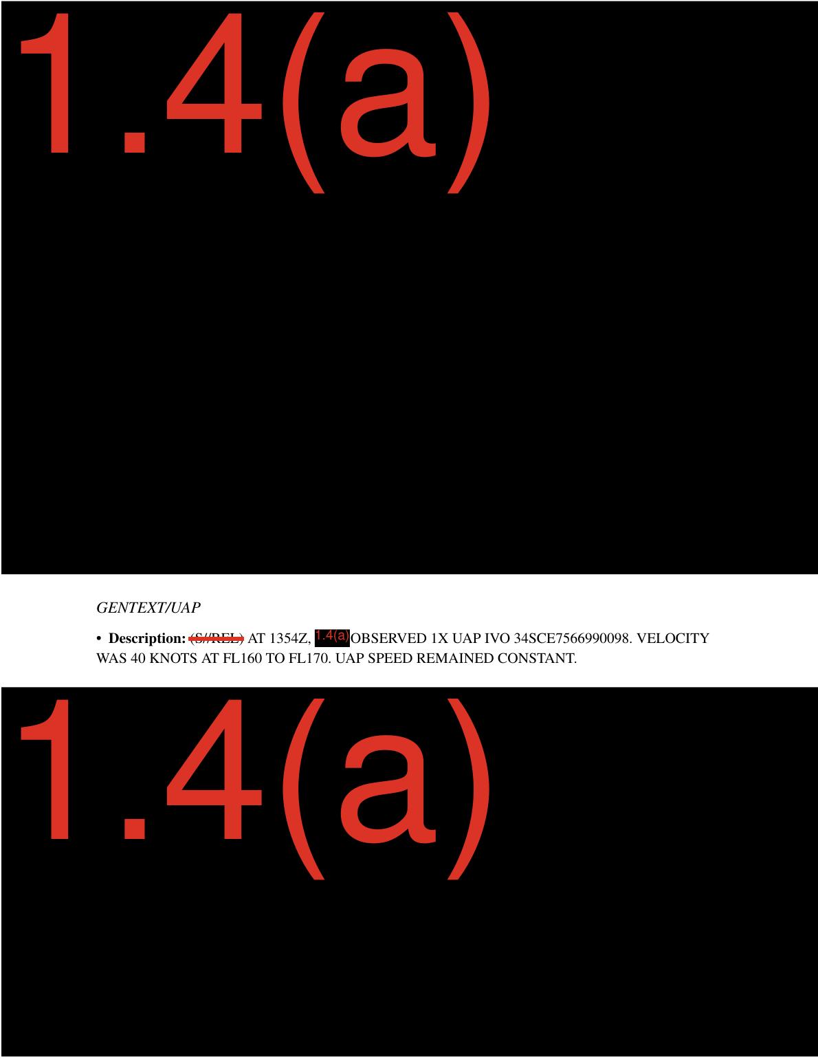
| 5 | GENTEXT/UAP entry: at 1354Z, a redacted source observed 1X UAP in the vicinity of 34SCE7566990098; velocity was 40 KNOTS at FL160 TO FL170; speed remained constant. | The observer/source line immediately after the timestamp is redacted under 1.4(a). |
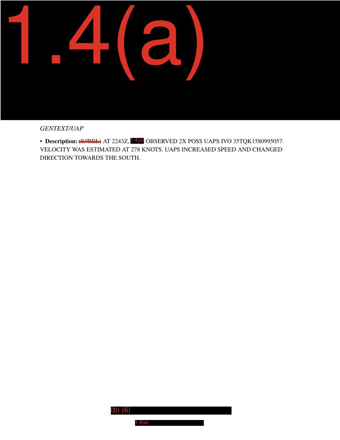
| 6 | GENTEXT/UAP entry: at 2243Z, a redacted source observed 2X POSS UAPS in the vicinity of 35TQK1580995057; velocity was estimated at 278 KNOTS; the objects reportedly increased speed and changed direction toward the south. | The page also carries bottom redactions marked (b) (6) and 1.4(a). |
The release-manifest description emphasizes the page-6 report about two possible UAPs and paraphrases the 278 KNOTS line. The actual visible PDF also includes the page-5 report of one UAP at 1354Z moving at 40 KNOTS between FL160 and FL170. Those two entries should be kept separate unless a later source proves they are part of the same event sequence.
Source custody and provenance
- Official PDF: https://www.war.gov/medialink/ufo/release_1/dow-uap-d5-mission-report-arabian-gulf-2020.pdf
- Open Sky release-file copy: war-gov-dow-uap-d5-mission-report-arabian-gulf-2020-b21122b1
- SHA-256:
af150a6b5139abc632446c9d5999fd5abc4f3c476c6245f173faabb6e2132d10 - File size:
30,588bytes; PDF metadata reports6letter-size pages. - Agency: Department of War.
- Release 01 CSV row:
56. - Incident date: the release record gives
N/A; the visible PDF pages expose times but no full calendar date. - Location/provenance tension: the released asset title says
Arabian Gulf, 2020, while the release-record field surfaced in graph context givesMediterranean Sea. The public page should not collapse those into a single resolved location without checking the official CSV row, the source PDF metadata, and any later release notes.
Graph context
The Open Sky graph currently has both a WAR.GOV release-record node and a PDF-asset node for this file. The semantic layer extracted 32 claim records, 22 entity mentions, 0 sensor-event records, and 0 table rows for this asset. The lack of sensor-event records is consistent with the source pass: the released PDF text reports observations, velocities, altitude bands, and grid references, but it does not include a raw radar return, sensor plot, imagery frame, or instrument readout.
Graph relationships also surface nearby Release 01 records such as DOW-UAP-D44 and DOW-UAP-D52. Those are useful navigation links only. This D5 page should not inherit visual evidence, sensor evidence, or conclusions from related records unless a later source explicitly connects them.
Leads to check
- Verify the location mismatch between the title phrase
Arabian Gulfand the release-record locationMediterranean Seaagainst the official CSV and any corrected WAR.GOV metadata. - Determine whether the page-5
1354Zone-UAP entry and the page-62243Ztwo-possible-UAP entry are separate reports, separate observations in one mission, or duplicated/redacted parts of a longer MISREP. - Geospatially review the visible grid references
34SCE7566990098and35TQK1580995057, while keeping in mind that surrounding operational context is redacted. - Check whether a mission-level record, video, still image, or additional attachment exists outside this PDF; the released PDF itself has none.
- If a full incident date and platform context are later recovered, run ordinary prosaic correlation checks: known aircraft activity, weather, astronomical visibility, satellite/launch tracks, and airspace context.
- Improve semantic extraction coverage so the page-5
1X UAPentry is as visible to search as the manifest-highlighted page-62X POSS UAPSentry.
Lead check notes
- Checked — The official PDF/release-file copy verifies to SHA-256
af150a6b5139abc632446c9d5999fd5abc4f3c476c6245f173faabb6e2132d10. Page renders confirm that pages 1-4 are full-page1.4(a)redactions and pages 5-6 are the only substantive visibleGENTEXT/UAPentries. - Partial — Available release metadata preserves a location mismatch rather than resolving it: the title and PDF URL say
Arabian Gulf, 2020, while the WAR.GOV CSV copy checked for the same PDF lists incident dateN/A, incident locationMediterranean Sea, and no DVIDS/video pairing. Open Sky release metadata and the downloaded CSV copy also disagree on row numbering for the same file, so row numbers should be treated as a metadata-cleanup issue. - Partial — Exact anchor searches in the current linked Release 01 OCR corpus found
34SCE7566990098,35TQK1580995057,1354Z,2243Z,278 KNOTS,FL170, and2X POSS UAPSonly in this D5 PDF. Broader strings such as1X UAPand40 KNOTSappear in other files too, but not with the D5 grid/time combination. That supports keeping the page-5 and page-6 entries as separate source lines until a mission-level record connects them. - Partial — A normal MGRS-format check places
34SCE7566990098roughly near36.05°N, 19.62°Eand35TQK1580995057roughly near45.08°N, 29.74°E. Treat those as coordinate-format checks only: the surrounding operation, platform, full date, and any map context are redacted, and the location metadata remains unresolved. - Checked — The semantic graph context already exposes page-5
40 KNOTSand page-6278 KNOTSmotion claims, but no sensor-event records. That matches the source: the visible PDF reports observation statements, not raw radar, FMV, or instrument data. - Blocked — Prosaic-correlation checks remain blocked until a full incident date, platform/sensor context, unredacted location handling, weather/traffic/astronomy inputs, or a separate mission attachment is available.
Deep investigation — graph + web reconnaissance
Source reread and media audit
This deep pass rechecked the hash-verified six-page release-file copy, derived page renders, PDF metadata, and visible text against the current WAR.GOV release metadata. The file remains a short redacted mission-report packet, not a media case file: pages 1-4 are full-page 1.4(a) redactions; page 5 contains the 1354Z 1X UAP line near 34SCE7566990098; page 6 contains the 2243Z 2X POSS UAPS line near 35TQK1580995057; and the PDF includes no object imagery, FMV still, radar plot, map, cockpit display, or raw sensor readout.
The PDF metadata reinforces the custody posture rather than adding case facts: the document title/subject match DOW-UAP-D5-Mission Report, Arabian Gulf, 2020, the verified file is 30,588 bytes with SHA-256 af150a6b5139abc632446c9d5999fd5abc4f3c476c6245f173faabb6e2132d10, and the PDF was generated/modified in the 2026 release window. The only substantive visible report fields remain the two concise GENTEXT/UAP entries already quoted above.
Graph reconnaissance
Read-only Neo4j checks found one exact official PDF asset record for the WAR.GOV media URL and the linked Release 01 CSV/manifest record. The asset is modeled as a current official CSV item with full-download status, 6 pages, 6 OCR pages, and the verified hash above. The semantic layer currently exposes 32 machine-extracted claims, 22 entity mentions, 0 sensor-event records, 0 table rows, and three source-text/manifest/OCR chunks for this asset.
Those graph records are navigation aids, not conclusions. They preserve the page-5 40 KNOTS / FL160 TO FL170 report and the page-6 278 KNOTS / southward-change report, but they do not add independent sensor evidence. The graph also exposes a metadata-cleanup problem: the D5 asset is tied to the canonical D5 PDF and current row 56, while a stale/adjacent D52 email-correspondence record and some OCR/manifest references carry overlapping body hashes or row-number references. That should be treated as provenance repair work, not as evidence that D5 and D52 describe the same event.
External provenance and web checks
Official-first checks confirmed the canonical WAR.GOV PDF URL, release landing-page anchor, and thumbnail path used by the current Open Sky record. Direct WAR.GOV fetches for the PDF/CSV/thumbnail can return 403 Forbidden; in that condition the hash-verified Open Sky release-file copy remains the working evidence copy while the official URL is retained as the canonical citation. A current WAR.GOV CSV copy represented in Open Sky metadata lists this asset with incident date N/A, incident location Mediterranean Sea, no DVIDS pairing, and the same PDF/thumbnail naming family.
No independent official mission attachment, video, map, radar plot, platform log, AARO/Defense.gov page, DVIDS record, NARA item, or Project Blue Book-style duplicate surfaced in this pass from exact-title, hash, grid-reference, time, and phrase searches. A community GitHub conversion of the same Release 01 file is reachable and can help with text comparison, but it is a secondary mirror of the release packet, not corroboration.
Prosaic checks and limits
The visible source text is too redacted for a full prosaic correlation. It supplies UTC-like times, two MGRS-like grid references, speed/altitude/direction language, and source labels, but no full calendar date, platform, sensor, weather, traffic, airspace, or mission context. The two visible grid references also sit in different UTM/MGRS zones; if interpreted literally as standard MGRS they support the existing location-metadata tension rather than resolving Arabian Gulf versus Mediterranean Sea.
The first checks before escalation are therefore provenance and context checks: resolve the row/location metadata, recover any mission-level attachment or unredacted context, identify the reporting platform/sensor if possible, and only then run weather, astronomy, satellite/launch, aircraft/balloon/drone, and airspace correlation. Until that context exists, the reported speeds and altitude band should remain source statements from a redacted MISREP, not independently verified performance data.
Follow-up leads
- Resolve the D5 row/location mismatch across the official CSV, Open Sky asset record, and graph relationships; separate any stale D52/body-hash relationship from the D5 PDF asset.
- Look for any companion mission package, unredacted MISREP, video/still attachment, or thumbnail-original file that explains the
1354Zand2243Zentries. - Keep page 5 and page 6 as separate source lines unless a later source proves they are one event sequence.
- If a full date/platform is recovered, rerun prosaic checks against aircraft operations, weather, astronomical visibility, satellite/launch tracks, and local airspace context.
Audit note
This section was added from source reread, render inspection, read-only graph queries, and official/archive-first web reconnaissance. No graph writes, findings, hypotheses, or resolution decisions were created.
Limits
This is not an adjudication. The terms UAP and POSS UAPS are source labels from the released report text. Most of the PDF is redacted, the observer/platform identity is not visible, no full date is exposed, and no underlying sensor or image evidence is included. The speed, altitude, direction, and grid-reference statements should be treated as reported fields in a redacted MISREP, not as independently verified performance data.
Sources
- Department of War / WAR.GOV,
DOW-UAP-D5, Mission Report, Arabian Gulf, 2020, Release 01 PDF: official file. - WAR.GOV/PURSUE Release 01 CSV record, row
56, as represented in Open Sky source metadata. - Open Sky release-file copy for this asset: release-file endpoint.
- Open Sky graph context for the Release 01 D5 asset and release-record nodes; graph counts are used here as navigation context, not findings.