DOW-UAP-D56, Range Fouler Debrief, Arabian Sea, August 2020
Evidence media
- Official PDF: Open Sky release-file copy.
- Derived page render from the official PDF:
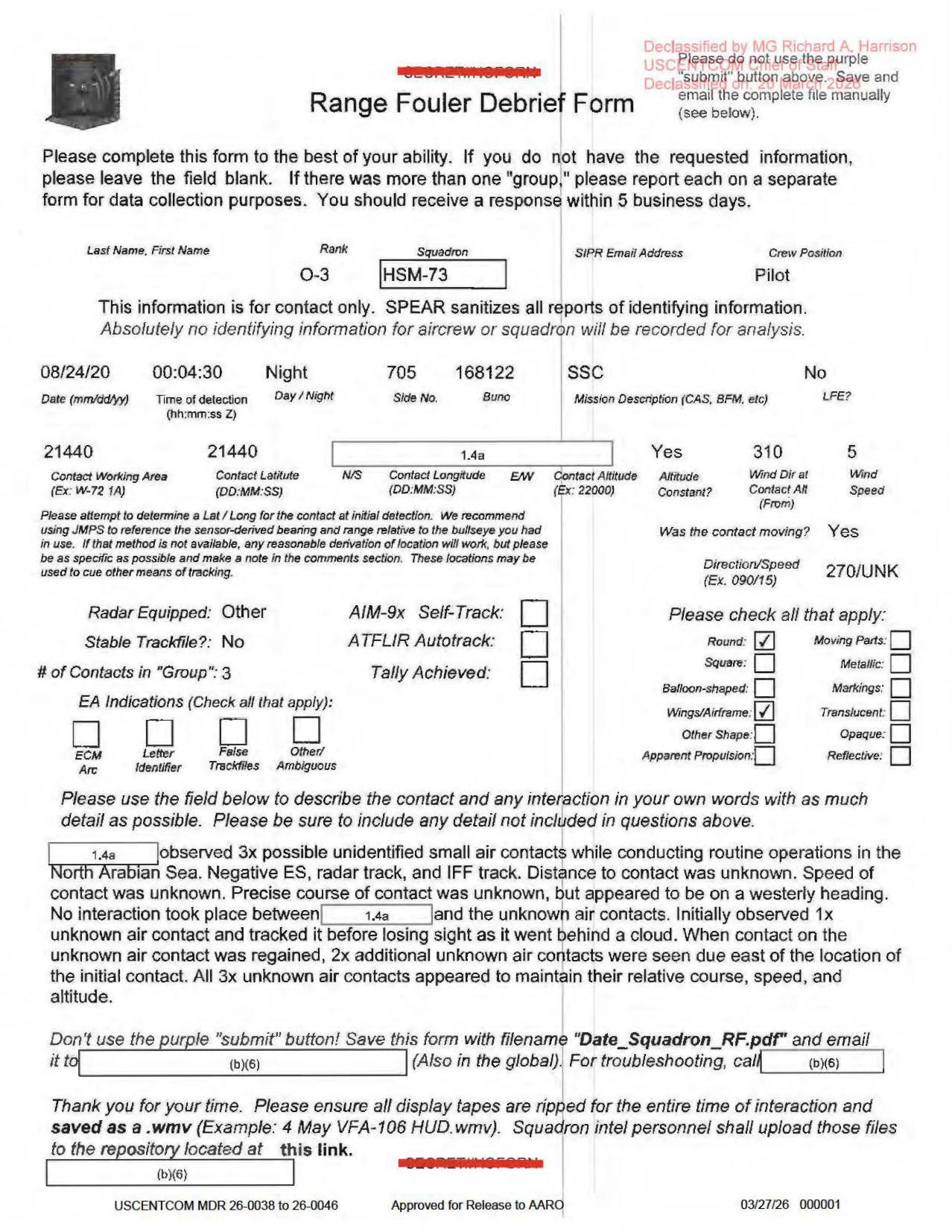
The render is the single released form page. It shows the Range Fouler Debrief fields and narrative, including the three-contact description, the negative ES/radar/IFF statement, and the .wmv display-tape instruction; it is not an object photograph, radar plot, map, or released video frame.
Investigation reading
This released file is a one-page scanned Range Fouler Debrief Form. It is best read as a contemporaneous reporting form plus one free-text narrative, not as a full sensor packet. The form records an August 24, 2020 nighttime report from a pilot associated with HSM-73 during routine operations in the North Arabian Sea. The central narrative says a redacted observer saw three possible unidentified small air contacts, initially tracking one contact before losing it behind a cloud and then seeing two additional contacts east of the first location after contact was regained.
The most important caution is that the form itself states negative instrument tracks: “Negative ES, radar track, and IFF track.” It also says distance, speed, and precise course were unknown, although the form field for direction/speed is filled as 270/UNK and the narrative says the contacts appeared to be on a westerly heading. This page preserves those source statements as reported; it does not identify the objects or resolve the event.
What the file appears to contain
The visible form fields show:
| Field | Reading |
|---|---|
| Form type | Range Fouler Debrief Form |
| Date/time | 08/24/20, 00:04:30 Z, night |
| Crew/reporting fields | Rank O-3, squadron HSM-73, crew position Pilot |
| Aircraft/mission fields | Side No. 705, BUNO 168122, mission description SSC, LFE No |
| Contact row | The working-area/coordinate row visibly includes 21440, with some coordinate cells redacted or unclear |
| Altitude/wind | Altitude constant Yes; wind direction 310; wind speed 5; no clear contact-altitude value visible |
| Motion | Contact moving Yes; direction/speed 270/UNK |
| Track fields | Radar equipped Other; stable trackfile No; AIM-9x self-track unchecked; ATFLIR autotrack unchecked; tally achieved unchecked |
| Group/shape fields | # of Contacts in "Group": 3; Round checked; Wings/Airframe checked; square, balloon-shaped, metallic, markings, translucent, opaque, reflective, moving parts, other shape, and apparent propulsion appear unchecked |
The free-text narrative says the contacts were “3x possible unidentified small air contacts” during routine operations in the North Arabian Sea. It states there was no interaction between the redacted reporting party and the contacts. It also says the first contact was lost behind a cloud; after reacquisition, two additional contacts were seen due east of the initial contact location, and all three appeared to maintain relative course, speed, and altitude.
The released PDF does not contain an object photograph, a map, a radar plot, a FLIR still, or an embedded video frame. The page is a scanned form. It does include an instruction near the bottom to ensure display tapes are ripped for the full interaction and saved as .wmv, but no such video file is present in this released PDF.
Source custody and provenance
- Official source URL: DOW-UAP-D56 PDF
- Open Sky release-file copy: open file
- SHA-256:
9127fb5a81efacf030df4dc6290d02bcdf4c8512cf1809b6eccfe6cf16a77f31 - File size:
1,849,972bytes - Page count:
1 - Release-row references checked here: indexed release record
62; downloaded Release 01 CSV data row65for the same title/PDF URL - Release-record incident metadata:
8/24/20, Arabian Sea - Release marking visible on the page: USCENTCOM MDR
26-0038 to 26-0046, approved for release to AARO, dated03/27/26
A provenance cleanup lead remains: the embedded PDF metadata reports title/subject DoW-UAP-D33, while the release URL, visible title context, CSV record, and file content identify this asset as DOW-UAP-D56.
Graph context
The graph has an official release-record node and a PDF-asset node for this item. It links the asset to the official primary source, OCR text, and semantic extraction records. Current graph context for the asset includes 46 extracted claims, 21 entity mentions, and 2 radar-labeled sensor events.
Those radar-labeled graph events need careful reading. One is triggered by the form label Radar Equipped: Other; the other quotes the narrative statement “Negative ES, radar track, and IFF track.” In this source, those are review/navigation cues, not raw radar evidence. The strongest source-backed content is the form’s visible fields and the observer narrative, especially the three-contact description, the cloud-loss/reacquisition sequence, and the explicit absence of ES/radar/IFF tracks.
Leads to check
- Locate whether any
.wmvdisplay tape or repository upload associated with this debrief was released elsewhere, withheld, or cataloged under a different record. - Confirm the coordinate row from a higher-quality source image: the rendered form shows
21440in the location row, but redaction and OCR noise make the precise coordinate fields unsafe to normalize. - Reconcile the form field
270/UNKwith the narrative wording that speed and precise course were unknown but the contacts appeared to be on a westerly heading. - Preserve the visual/OCR discrepancy around the shape row: visual review supports
Wings/Airframechecked, while OCR text can misread that row. - Reconcile the embedded PDF metadata label
DoW-UAP-D33with the D56 release record. - Compare this debrief with nearby Release 01 Arabian Sea / Arabian Gulf range-fouler forms before treating repeated form labels as independent corroboration.
Lead check notes
- Blocked — display-tape /
.wmvtrail: The page instructs personnel to rip display tapes as.wmv, and the same instruction appears in several current linked Release 01 range-fouler records, including D38, D42, D44, D56, D57, and D58. The D56 release metadata and downloaded CSV row expose the PDF with blank video-pairing and DVIDS fields; no D56-specific display tape, video frame, still image, or repository file is present in the released sources checked here. - Partial — coordinate row: The official PDF render and OCR both show
21440in the working-area/latitude row and a redacted longitude cell, but that is not enough to normalize a location. An unredacted source image, mission log, JMPS/bullseye derivation, or released display tape would be needed before mapping the contact. - Checked — direction/speed wording: The form field reads
270/UNK, while the narrative separately says distance, speed, and precise course were unknown but appeared westerly. Those statements are not contradictory on their face:270records an approximate westward direction andUNKpreserves unknown speed; the precise course remains unresolved. - Partial — shape checkbox/OCR: The derived render visually supports
RoundandWings/Airframechecked and the other visible shape/track boxes unchecked. Stored OCR can read that row asWings/Antennae, so this remains a transcription-quality issue unless another cleaner source page is found. - Partial — D56/D33 metadata and row references: The visible release title, PDF URL, and verified SHA-256 identify this asset as D56. Embedded PDF metadata reports
DoW-UAP-D33, and release-row references are not fully aligned: the indexed release record carries62, while the downloaded Release 01 CSV table places the same title/PDF URL at data row65. Use the title, URL, and SHA-256 as stable identifiers until official manifest history resolves the row/metadata tension. - Partial — nearby range-fouler comparison: Current linked-corpus search found the display-tape instruction in D38, D42, D44, D56, D57, and D58. Exact D56 anchors such as
21440,270/UNK,HSM-73, andNorth Arabian Seaappeared confined to this D56 OCR file, so nearby forms are useful for template/context review but not independent corroboration of this event.
Limits
This is not an adjudication. The released file is one redacted form page with no released raw sensor track, no IFF/radar plot, no object imagery, and no linked display tape in the PDF. The observer’s descriptive terms, including “round,” “wings/airframe,” and “possible unidentified small air contacts,” are report language from the form and should not be treated as confirmed object properties without the missing supporting media or additional records.
The form’s checkboxes and narrative are useful for triage, but several fields are redacted, blank, or unclear. The graph extraction is useful for navigation, yet some sensor events are generated from form prompts or negative statements. Further review should stay at the source-text level until additional primary material is located.
Deep investigation — graph + web reconnaissance
Source reread and media scope
A source-page reread confirms this asset is a one-page, copy-restricted scanned Range Fouler Debrief Form: 1,849,972 bytes, SHA-256 9127fb5a81efacf030df4dc6290d02bcdf4c8512cf1809b6eccfe6cf16a77f31, with 0 embedded files and a single scanned page image. The embedded PDF metadata still reads DoW-UAP-D33, but the official URL, visible title context, release manifest text, page OCR, and page render identify this public asset as DOW-UAP-D56. The page contains no object photograph, map, radar plot, FLIR/sensor still, cockpit display, or released video frame.
The high-signal source facts remain bounded to the form and its narrative. The rendered page supports 08/24/20, 00:04:30 Z, Night, rank O-3, squadron HSM-73, crew position Pilot, side 705, BUNO 168122, mission SSC, and LFE: No. The location row visibly includes 21440 and a redacted 1.4a cell; it is not enough to normalize a coordinate. The movement field says Yes, direction/speed is 270/UNK, stable trackfile is No, AIM-9X self-track and ATFLIR autotrack are unchecked, tally achieved is unchecked, and the group count is 3. Page-image review supports Round and Wings/Airframe as checked appearance boxes, while stored OCR can misread the row as Wings/Antennae; that should remain a transcription-quality issue.
The narrative says a redacted observer saw 3x possible unidentified small air contacts during routine operations in the North Arabian Sea. It explicitly states Negative ES, radar track, and IFF track, with distance, speed, and precise course unknown, though the contacts appeared to be on a westerly heading. The described sequence is visual/report language: one contact was tracked, lost behind a cloud, then reacquired with two additional contacts due east of the first location; all three appeared to maintain relative course, speed, and altitude.
Graph connections and provenance tensions
Read-only graph checks match the stable D56 PDF asset by exact official URL, title, and SHA-256. The asset node is modeled as official-primary Release 01 material and links to the official source, five text chunks, the OCR text, and semantic extraction records. The graph also exposes row/relationship drift that belongs in the provenance-cleanup lane: a current row-62 D56-titled release-record relationship carries stale D52 file fields, while a row-65 D6-titled record points at the D56 final URL and byte count through a non-current relationship. Until the official manifest history is reconciled, the exact file URL, visible title, and SHA-256 are stronger identifiers than row number alone.
The semantic layer for this asset contains 46 machine-extracted claim records, 21 entity mentions, and 2 sensor-event records. Those records are useful for navigation, not adjudication. Both sensor-event records are RADAR-labeled machine leads: one is triggered by the form area around Radar Equipped: Other, and the other quotes Negative ES, radar track, and IFF track. Neither is a positive radar return or an independent sensor observation in the released source.
Targeted graph context checks did not find modeled AstronomyEvent, LaunchEvent, or WeatherEvent records for 2020-08-24, and the graph has no useful exact North Arabian Sea location node for this asset beyond source text and broad/cross-corpus regional labels. That is graph-coverage information, not an external exclusion; the released page lacks the unredacted position, platform geometry, look direction, elevation, and display tape needed for credible prosaic correlation.
External provenance and official-source checks
Direct WAR.GOV probes for the D56 PDF, Release 01 landing page, and official CSV returned 403 Forbidden during this check. That is not a custody failure because the cached official-primary file verifies by byte size, hash, page count, and rendered content. Internet Archive availability/CDX probes for the exact official PDF URL returned rate-limit/service errors during this check, so no new archive snapshot was added here.
The checked release metadata exposes the PDF only: video-pairing and DVIDS fields are blank for this D56 item, and no D56-specific display tape, .wmv, still image, or public video frame is present in the released package. A live exact-title DVIDS probe returned no usable public result, while Defense.gov and AARO search probes were blocked by 403 responses. A secondary UFO-USA GitHub CSV copy preserves the D56 title, description, incident date, Arabian Sea location, and official PDF URL, but it remains a derived mirror lead rather than the canonical source.
Prosaic checks and unresolved questions
The first ordinary-source lane is a nighttime visual report of small air contacts near cloud, with no positive ES/radar/IFF track in the released source. The form's own 270/UNK and westerly-heading language may describe an apparent direction, but speed, distance, altitude, precise course, and source geometry are missing. Aircraft, ship/aircraft lighting, drone, balloon, weather/cloud, astronomy, satellite, and launch checks cannot be run credibly from this page alone without the unredacted location row, observer/platform track, look direction, elevation angle, timing precision beyond the single detection time, and any preserved display tape.
Concrete follow-up work is therefore source-driven: locate whether the referenced display-tape repository or .wmv file was ever released or cataloged under another record; reconcile the D56/D33 metadata and D52/D6 row drift; obtain a cleaner or unredacted coordinate/source image for the 21440 row; and compare HSM-73 / side 705 / BUNO 168122 operational context, cloud conditions, and local traffic only if authoritative records become available.
Audit note
No finding, hypothesis, or resolution decision is created here. The added material separates verified source text and page-image observations from machine-extracted graph leads, external provenance checks, prosaic blockers, and unresolved follow-up work.
Sources
- Department of War / PURSUE Release 01,
DOW-UAP-D56, Range Fouler Debrief, Arabian Sea, August 2020, official PDF URL above. - Release 01 row references and associated release-record metadata, including the row-number tension noted above.
- Verified released-file SHA-256:
9127fb5a81efacf030df4dc6290d02bcdf4c8512cf1809b6eccfe6cf16a77f31. - Open Sky graph context for the official release-record and PDF-asset nodes, used here only as investigation context.