DOW-UAP-D57, Range Fouler Reporting Form, Gulf of Aden, September 2020
Evidence media
- Official PDF: Open Sky release-file copy
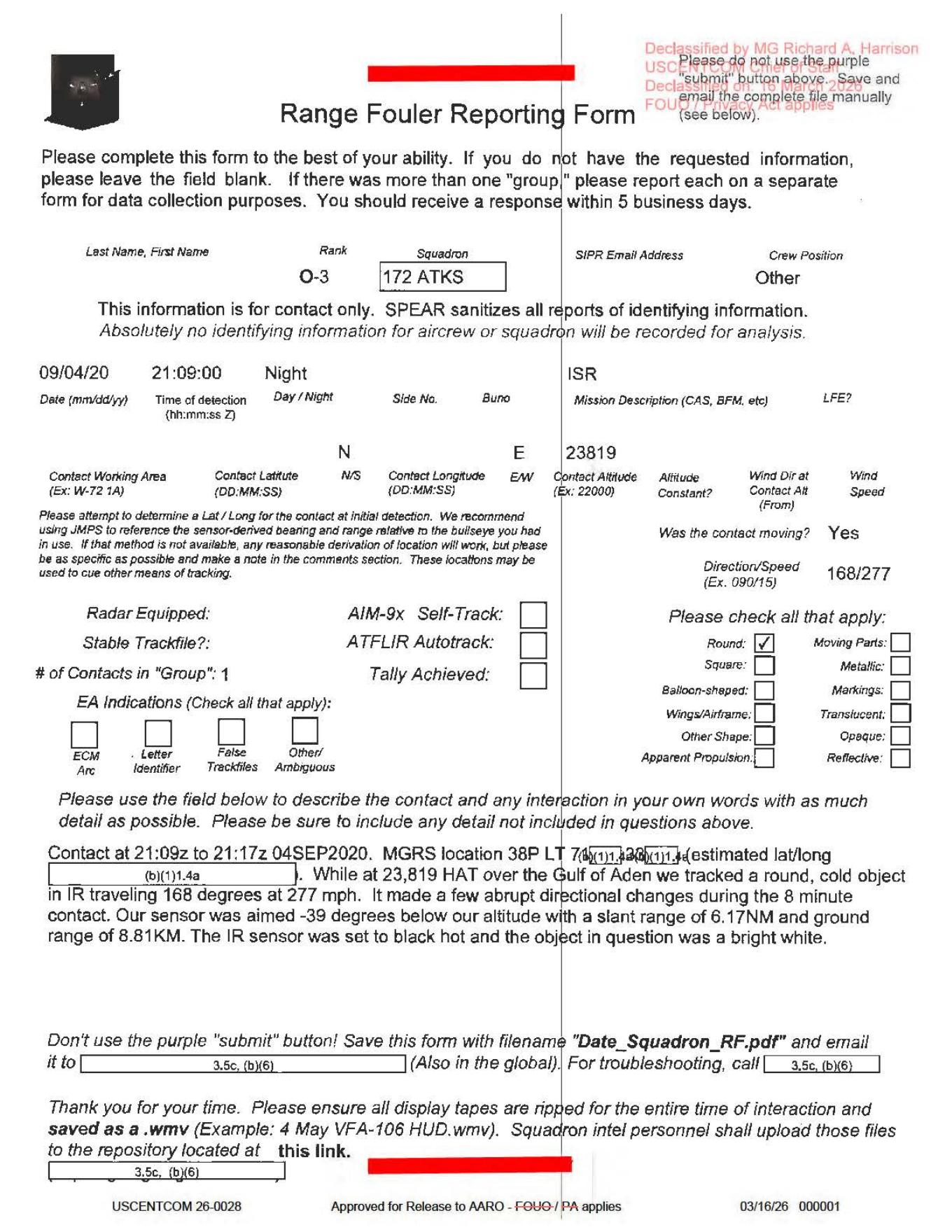
This derived page render shows the one-page Range Fouler Reporting Form: the 09/04/20 night ISR entry, 168/277 direction/speed field, one reported contact, and the narrative describing a reported round, cold IR-tracked object over the Gulf of Aden. The released page is a form page, not an object photograph, map, radar plot, or video frame.
Investigation reading
This released file is a single-page Range Fouler Reporting Form for a reported contact over the Gulf of Aden on 4 September 2020. The page is a filled form plus redactions and release markings; it is not an image packet. I read the full OCR text, checked the selectable text layer, rendered the page for visual review, and verified the released PDF hash against release metadata.
The high-signal part is the free-text narrative near the bottom of the form. It reports a contact from 21:09z to 21:17z on 04SEP2020, with an MGRS location beginning 38P LT 74... and the estimated latitude/longitude redacted. The observer/form text says that while at 23,819 HAT over the Gulf of Aden, the crew tracked a round, cold object in IR traveling 168 degrees at 277 mph; it says the object made a few abrupt directional changes during the eight-minute contact. The form also says the IR sensor was in black-hot mode and that the object appeared bright white.
What the file appears to contain
The visible form fields identify the reporter as an O-3 from 172 ATKS, crew position Other, with mission description ISR. The date/time row reads 09/04/20, 21:09:00, and Night. The contact-altitude field is filled as 23819. The contact is marked as moving, with direction/speed 168/277, matching the narrative wording of 168 degrees and 277 mph. The number of contacts in the group is 1.
The object-description checkbox row is important because it distinguishes the actual form entry from later summaries. Round is visibly checked; the other shape/material checkboxes visible on the page, including square, balloon-shaped, wings/airframe, moving parts, metallic, markings, translucent, opaque, reflective, other shape, and apparent propulsion, appear blank. The AIM-9X self-track, ATFLIR autotrack, tally-achieved, and electronic-attack indication boxes also appear blank or unfilled in the rendered page.
There is no released object photo, map, radar plot, FLIR/IR frame, HUD still, or embedded video frame on this page. The bottom instruction tells personnel to rip display tapes for the entire interaction and save them as .wmv files, but this PDF itself does not include those tapes.
One field needs careful follow-up: the rendered/text-layer reading of the sensor geometry appears to show a slant range of 6.17NM and a ground range of 8.81KM, while stored OCR can read the slant-range unit as KM. That is a source-quality issue to check against the page image and any original form/video packet before reusing the geometry.
Source custody and provenance
The official/source URL is https://www.war.gov/medialink/ufo/release_1/dow-uap-d57-mission-report-gulf-of-aden-september-2020.pdf. The Open Sky release-file route for this page is /api/explore/war-gov/release-file/war-gov-dow-uap-d57-range-fouler-reporting-form-gulf-of-aden-september-2020-c2961d7c. The verified PDF size is 295,447 bytes and the SHA-256 is 2565433b0ac938d6123c611be75b30ec6cf99c192e71dbf4ef53c40a6852ca00.
The current release row modeled for this asset is CSV row 63; the row record supplies incident date 9/4/20 and incident location Gulf of Aden. The PDF metadata reports Title: DoW-UAP-D34 / Subject: DoW-UAP-D34, which does not match the visible D57 title and official URL. That looks like a PDF-metadata carryover or packaging mismatch, not evidence that the page should be reassigned without checking the release manifest and original file history.
The footer/release stamp is visually noisy but includes USCENTCOM 26-0028, approval for release to AARO, privacy/release language, and a March 2026-style release date. Exact footer wording should be checked against the rendered page before it is used as a citation anchor.
Graph context
Open Sky currently models this asset as an official primary Document plus a separate release-row Document from the WAR.GOV/PURSUE Release 01 source. The graph has 34 extracted claim records, 22 entity mentions, and 5 sensor-event records for this page. Those graph facts are useful navigation cues, but they remain source-text extraction, not adjudication.
The sensor extraction should be read narrowly. Multiple IR events are supported by the narrative and manifest language: the page says the contact was tracked in IR, black-hot mode, with the object appearing bright white. The graph also has a RADAR sensor event, but the source quote comes from the form label Radar Equipped: near blank tracking fields. The released page does not show a radar return, radar plot, populated radar narrative, or independent radar track. Treat that radar extraction as a form-label review cue unless later source material supplies more.
Candidate crosslinks are also review leads only. Some are triggered by shared geography such as Gulf of Aden or nearby Release 01 records; others appear to be inherited from adjacent Mediterranean/Gulf records. None of those links should be presented as corroboration until a human compares the underlying source texts.
Leads to check
- Locate any associated
.wmvdisplay tapes or repository upload referenced by the form; the PDF instructs personnel to save video, but no video is embedded here. - Recheck the slant-range unit on the page image (
6.17NMversus OCR6.17KM) before using the geometry in map or kinematic analysis. - Verify whether the blank radar/AIM-9X/ATFLIR/tally fields were truly unfilled on the original form, rather than lost through scan quality or redaction.
- Reconcile the PDF metadata mismatch (
DoW-UAP-D34) with the visible D57 title, official D57 URL, and CSV row63. - Run prosaic/context checks before escalation: local maritime/air traffic, weather/cloud conditions, sensor angle/black-hot artifacts, range geometry, and any available crew/display tape context.
Lead check notes
- Checked — release-file scope: The verified Open Sky release-file copy is a one-page PDF with SHA-256
2565433b0ac938d6123c611be75b30ec6cf99c192e71dbf4ef53c40a6852ca00. The PDF has no embedded attachments, and the current release metadata for row63exposes no DVIDS/video pairing for D57. - Partial — display-tape trail: The
.wmv/display-tape instruction appears in several linked Release 01 range-fouler forms, so it reads like a reporting-template instruction rather than a D57-specific released video. Exact D57 anchors such as38P LT 74,21:09z,21:17z,168/277, andround, cold objectwere found only in the D57 OCR in the current linked corpus; locating any actual display tape still needs a separate repository, MDR/AARO, DVIDS, or operational-media source. - Checked — slant-range unit: The derived page render supports
slant range of 6.17NMandground range of 8.81KM; the6.17KMOCR reading is best treated as an extraction-quality issue unless another source copy confirms it. - Partial — form fields: Page-image review supports
Roundchecked, one contact, moving contactYes, direction/speed168/277, and blank-looking radar/AIM-9X self-track/ATFLIR autotrack/tally fields. A higher-quality original form or associated video/source packet is still needed before treating those blank fields as complete operational evidence. - Needs external source — provenance and context: The visible title, official URL, release row
63, and verified hash identify this as D57, while the PDF metadata title/subject saysDoW-UAP-D34; resolving that mismatch needs official manifest-history or corrected-file evidence. Prosaic checks also remain blocked by redacted coordinates and missing display tape/raw sensor context.
Limits
This page is a source-reading draft, not a finding. It preserves what the released one-page form appears to say and flags extraction/provenance issues for human review. The page contains a narrative report and form fields, not the underlying video, not a radar product, and not an independent resolution. Redactions remove the exact location and contact information. The reported direction, speed, shape, temperature impression, and motion are source claims from the form and need corroboration before any stronger conclusion is drawn.
Deep investigation — graph + web reconnaissance
Source reread
The verified release-file copy remains a one-page, letter-size PDF (295,447 bytes; SHA-256 2565433b0ac938d6123c611be75b30ec6cf99c192e71dbf4ef53c40a6852ca00). PDF metadata still says Title: DoW-UAP-D34 / Subject: DoW-UAP-D34, but the visible release row, official URL, page title, and asset hash all identify this page as D57. Treat the D34 metadata as a packaging/provenance-cleanup issue, not a reason to reassign the source.
The page render and text layer support the same core source reading: a night ISR-related Range Fouler Reporting Form dated 09/04/20, with narrative contact from 21:09z to 21:17z on 04SEP2020. The visible fields include rank O-3, squadron 172 ATKS, crew position Other, one contact in the group, movement marked Yes, direction/speed 168/277, and mission description ISR. The narrative places the report over the Gulf of Aden with an MGRS prefix beginning 38P LT 74... before redaction; it says the crew tracked a round, cold object in IR, traveling 168 degrees at 277 mph, with a few abrupt directional changes during the eight-minute contact.
The form-field and image review are important for sensor interpretation. Round is the only clearly checked descriptive box. Radar-equipped, stable trackfile, AIM-9X self-track, ATFLIR autotrack, tally-achieved, and EA-indication fields are not visibly populated on the released page. The page render/text layer support a slant range of 6.17NM and ground range of 8.81KM; the stored OCR reading of 6.17KM is therefore best handled as an extraction-quality tension until a higher-quality source copy or associated sensor packet is available.
Graph connections
The graph matches two official-primary Document records for this item: the WAR.GOV release-row record and the exact linked PDF asset record. The asset record carries the stable identifiers for this investigation: the D57 official URL, 295,447-byte content length, and SHA-256 above. The release-row graph record keeps D57 title/row context but also shows stale neighboring-file fields (final_url/content length from a D54-era row state), while a nearby D60 row record can carry the D57 final URL/byte count. Those are row-reconciliation leads, not separate events or corroboration.
Semantic graph material for the asset currently consists of 34 machine-extracted claims, 22 entity mentions, and 5 sensor-event records. Four sensor-event records are IR/black-hot cues grounded in the page text. The RADAR sensor event is a form-label extraction from the blank-looking Radar Equipped area, not evidence of a radar return, trackfile, or radar plot. Candidate crosslinks and neighboring-row relationships should remain review leads only; they are driven largely by shared release family, range-fouler wording, geography, or row drift rather than independently verified source overlap.
External provenance and context checks
The canonical public source remains WAR.GOV/PURSUE Release 01: https://www.war.gov/medialink/ufo/release_1/dow-uap-d57-mission-report-gulf-of-aden-september-2020.pdf, with release-row metadata for row 63 and release date 5/8/26. Direct live fetches of the WAR.GOV PDF, landing page, CSV, and press-release URL returned 403 Access Denied from this environment during this check, so the verified cached official-primary bytes and graph/source manifest are the custody anchors for now. Internet Archive availability/CDX probes for the exact PDF were rate-limited or unavailable (429/503). DVIDS search returned a CloudFront/WAF challenge, and AARO/Defense.gov search probes returned 403; no current graph or release-row field supplies a D57 DVIDS/video pairing.
A conservative graph context probe did not produce a useful astronomy/weather/launch/satellite correlation for this redacted Gulf of Aden report. The sample date/location matches were unrelated civilian-case false positives where aden appeared inside place names such as Bradenton or Pasadena. That means the context lane is still blocked, not cleared.
Prosaic checks and follow-up leads
Prosaic analysis should start with the source's own missing-data problem: exact coordinates are redacted, the platform/sensor details are incomplete, and the display tape or .wmv repository material referenced by the form is not included in the released PDF. Without those items, the reported 277 mph, bearing, range, and abrupt-direction-change language cannot be separated from possible line-of-sight geometry, platform/sensor motion, tracking/display behavior, black-hot/contrast settings, or environmental/maritime/air-traffic context.
Follow-up priorities are therefore: locate any associated display tape/source packet; obtain unredacted or higher-quality geometry if it becomes lawfully available; reconcile the D34 PDF-metadata and D54/D60 row-field drift; confirm whether the visible blank tracking fields were truly unfilled on the original form; and run weather, traffic, satellite/launch, and maritime checks once precise time/location/sensor geometry are available.
Audit note
This section adds graph-and-web reconnaissance only. It does not create a finding, hypothesis, or resolution. The released source supports a reported IR observation on a form; it does not provide the underlying video, a radar product, a map/track, or an independent identification.
Sources
- Official PDF: dow-uap-d57-mission-report-gulf-of-aden-september-2020.pdf
- Open Sky release-file route: /api/explore/war-gov/release-file/war-gov-dow-uap-d57-range-fouler-reporting-form-gulf-of-aden-september-2020-c2961d7c
- WAR.GOV/PURSUE Release 01 current row modeled in Open Sky: row
63, Department of War, incident date9/4/20, incident locationGulf of Aden. - Verified file hash:
2565433b0ac938d6123c611be75b30ec6cf99c192e71dbf4ef53c40a6852ca00.