DOW-UAP-D60, Mission Report, Arabian Gulf, August 2020
Evidence media
- Official PDF: Open Sky release-file copy
The images below are derived page renders from the official PDF. They are source-document pages, not standalone object imagery or released FMV frames.
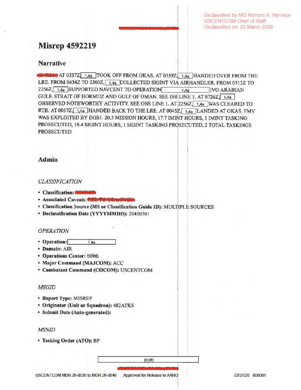
Page 1 preserves the mission narrative: OKAS takeoff, LRE handover, SIGINT collection via AIRHANDLER, NAVCENT support in the Arabian Gulf / Strait of Hormuz / Gulf of Oman area, 0726Z noteworthy activity, return-to-base timing, and the statement that FMV was exploited by DGS1.
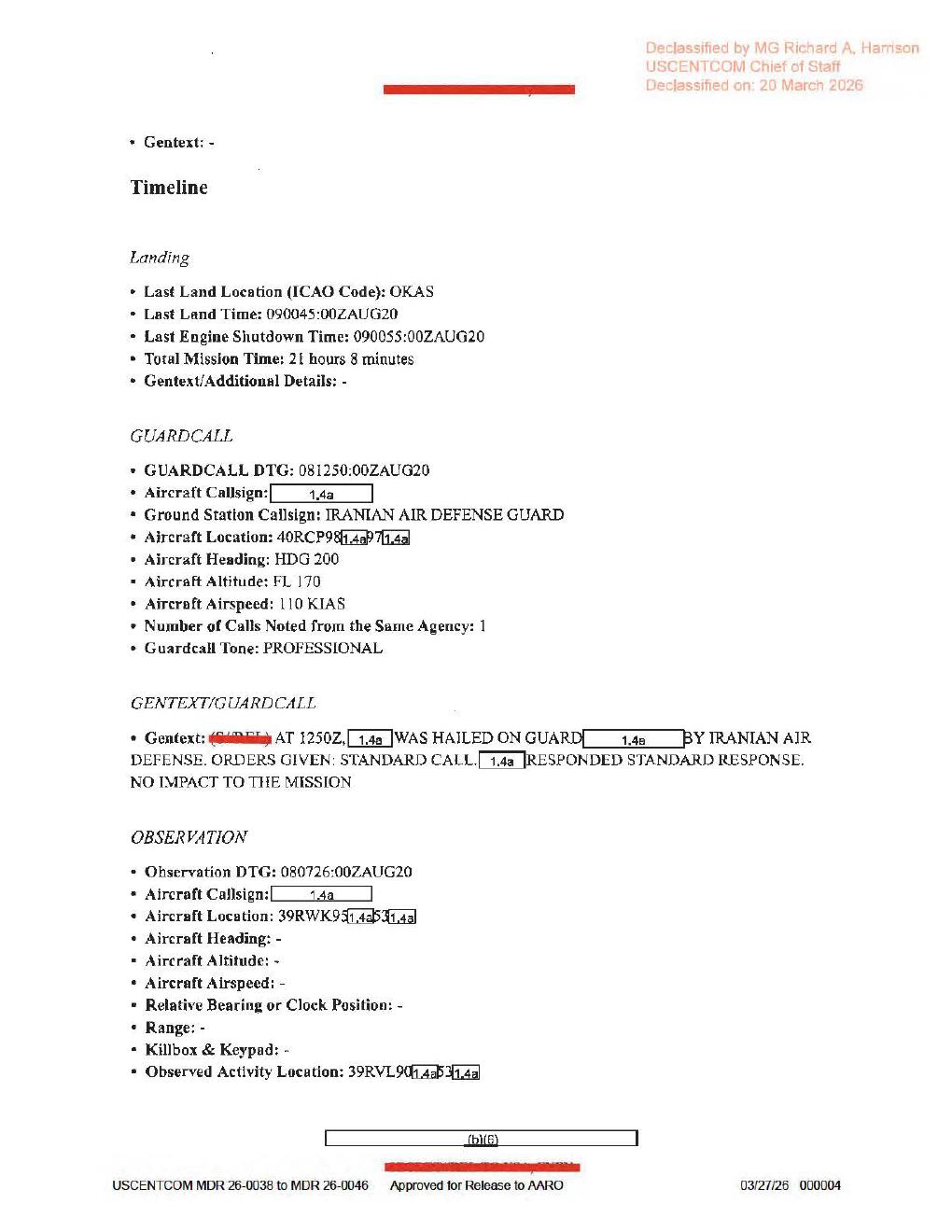
Page 4 contains the guard-call block and start of the observation block. It supports GUARDCALL DTG: 081250:00ZAUG20, Observation DTG: 080726:00ZAUG20, and several partially redacted MGRS-like location fragments; the hidden characters remain redacted.
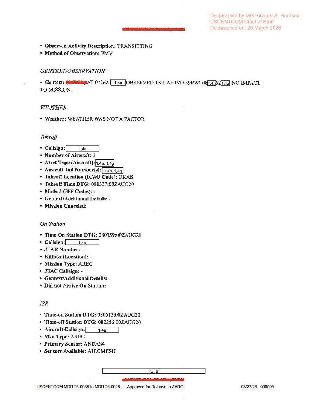
Page 5 is the main observation page. It shows Observed Activity Description: TRANSITTING, Method of Observation: FMV, a 0726Z gentext line for 1X UAP near a partially redacted 39RWL08... location, NO IMPACT TO MISSION, observation-specific weather as not a factor, and the visible sensor fields ANDAS4 and AH\GMESH.
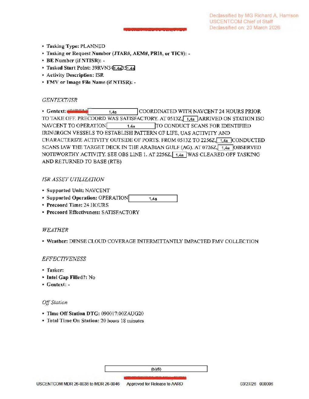
Page 6 is the ISR/tasking continuation. It shows FMV or Image File Name (if NTISR): -, repeats the 0726Z noteworthy-activity pointer, states that dense cloud coverage INTERMITTANTLY impacted FMV collection, and gives the off-station timing as 090017:00ZAUG20.
Investigation reading
This is a six-page USCENTCOM mission-report PDF from Release 01. I treated it as a short MISREP/form packet: verified the released file size and SHA-256, checked all six OCR page markers, rendered every page for visual review, and compared the rendered pages against OCR where the important fields looked noisy.
The source is text/form evidence. No page contains an object photograph, map, radar plot, FMV still, cockpit display, track graphic, or other visual sensor frame. The report says the observation method was FMV, but the released PDF itself does not include the FMV file, a still frame, or a populated image filename.
The central source reading is narrow: during an ISR mission in the Arabian Gulf / Strait of Hormuz / Gulf of Oman area, the form records one UAP observation around 0726Z on 08 Aug 2020, described in the observation line as TRANSITTING and observed by FMV, with NO IMPACT TO MISSION. That is a report statement, not an adjudication of what the object was.
What the file appears to contain
| Page | Source reading |
|---|---|
| 1 | Narrative/admin page for MISREP 4592219. The rendered page says the aircraft took off from OKAS, handed over from the LRE, collected SIGINT via AIRHANDLER, supported NAVCENT near the Arabian Gulf, Strait of Hormuz, and Gulf of Oman, observed noteworthy activity at 0726Z, returned to base, and that FMV was exploited by DGS1. The page is text only. |
| 2 | Mission/admin routing page. It lists mission type AREC, country tasked US - UNITED STATES, service tasked A - AIR FORCE, POC/QC/approver roles, 482 ATKS / 432 AEW / 603 AOC / 609 AOC / 609 CAOC context, and redacted personal fields. No UAP content or imagery appears on this page. |
| 3 | Aircraft/equipment page. Most radar, RWR, MWS, IRCM, ECM, chaff/flare, towed decoy, air-to-air missile, and gun fields are dashed. The rendered page shows TGT Pod Name or Designator: ANDAS4 and Additional Avionics: AH_GMESH; the air-to-ground weapon field is redacted. This is equipment context, not a raw radar/IR return. |
| 4 | Timeline, landing, guard-call, and start of observation page. The rendered page gives landing at OKAS, guard-call DTG 081250:00ZAUG20, ground station IRANIAN AIR DEFENSE GUARD, heading HDG 200, altitude FL 170, airspeed 110 KIAS, and guard-call tone PROFESSIONAL. The observation section begins with Observation DTG: 080726:00ZAUG20; heading, altitude, airspeed, bearing, range, and killbox fields for the observation are blank/dashed. Aircraft location is partly visible as 39R?K9...5...; observed-activity location is partly visible as 39R?L90...5..., with redacted characters and one OCR-sensitive letter unresolved. |
| 5 | Main observation continuation. The rendered page reads Observed Activity Description: TRANSITTING, Method of Observation: FMV, and a gentext line reading, in substance: at 0726Z, a redacted caller observed 1X UAP near a partly redacted 39RWL08... location, with NO IMPACT TO MISSION. The observation-specific weather line says WEATHER WAS NOT A FACTOR. Takeoff, on-station, and ISR fields list one aircraft, takeoff from OKAS at 080337:00ZAUG20, on station at 080359:00ZAUG20, ISR from 080513:00ZAUG20 to 082256:00ZAUG20, mission type AREC, primary sensor rendered as ANDAS4, and sensors available rendered as AH\GMESH. |
| 6 | ISR tasking/utilization page. It says tasking type PLANNED, activity description ISR, and FMV or Image File Name (if NTISR): -. The ISR gentext says the mission coordinated with NAVCENT 24 hours before takeoff, precoordination was satisfactory, the asset arrived on station at 0513Z, scanned for identified IRN/IRGCN vessels, pattern-of-life, UAS activity, and activity outside ports, conducted scans in the Arabian Gulf from 0513Z to 2256Z, observed noteworthy activity at 0726Z, and returned to base. The broader ISR weather field says dense cloud coverage INTERMITTANTLY impacted FMV collection. |
Two distinctions matter for interpretation. First, the specific observation page says weather was not a factor, while the broader ISR page says dense cloud cover intermittantly impacted FMV collection. Those are different form contexts and should not be collapsed without the underlying FMV. Second, UAS activity appears in the ISR mission objective on page 6; it is not the same term as the 1X UAP observation line on page 5.
Source custody and provenance
- Official file URL: https://www.war.gov/medialink/ufo/release_1/dow-uap-d60-mission-report-persian-gulf-august-2020.pdf
- Open release-file route: /api/explore/war-gov/release-file/war-gov-dow-uap-d60-mission-report-arabian-gulf-august-2020-39c999bd
- Release row:
66 - Agency: Department of War
- Container: PDF,
6pages,2,412,310bytes - SHA-256:
39126406547c89dbc81112c5638612858fcfe7e38179dd89e6d725dc6cee13b1 - OCR coverage:
6 / 6pages with text - Release-record incident date/location:
8/8/20,Arabian Gulf
The public title uses Arabian Gulf, while the official media filename uses persian-gulf-august-2020. The embedded PDF metadata title/subject surfaced as DoW-UAP-D36 during file inspection even though the visible release title and official URL are D60. Treat both as provenance-cleanup leads, not as a reason to reassign the page.
Graph context
Open Sky has both the release-record node and the PDF-asset node for this item. The semantic graph currently preserves 86 extracted claims, 77 entity mentions, 11 sensor-event records, and 0 table rows for this asset.
The useful graph signal is that the UAP-related observation is tied to the official PDF asset, the Release 01 record, and OCR chunks for all six pages. The caution is that several sensor-event records are triggered by form labels or equipment context. For example, page 3 contains dashed radar/RWR/MWS/IRCM fields and page 6 has a blank FMV or Image File Name field; those should be used as navigation cues, not presented as raw radar, IR, or video evidence. The source-backed media term for the observation is FMV as a stated method, not released FMV imagery.
Related Release 01 graph links include nearby or similarly structured records such as D57 and D63. Candidate crosslinks based on geography or phrase matching are review leads only; this draft makes no connection finding.
Leads to check
- Locate whether an underlying FMV clip, still frame, exploitation package, or DGS1 product exists for the
0726Zobservation; the released PDF does not include it. - Verify the rendered-page transcription against any original-source or higher-fidelity copy before updating structured graph fields. High-signal OCR conflicts include page 5 reading
0728Z/398WL0...in OCR versus rendered0726Z/39RWL08..., and the activity description rendered asTRANSITTINGwhile OCR normalizes it toTRANSITING. - Resolve page 1 and page 4 OCR conflicts around timing: the rendered page shows handover around
0359Zand SIGINT ending around2300Z, while OCR variants show0339Zand2306Z; the guard-call render shows081250:00ZAUG20/1250Z, while OCR misreads that section. - Check the partial MGRS-like fields (
39R?K9...5...,39R?L90...5...,39RWL08...) against a better release image before using them for map placement. - Separate observation-specific weather (
WEATHER WAS NOT A FACTOR) from broader ISR collection weather (DENSE CLOUD COVERAGE INTERMITTANTLY IMPACTED FMV COLLECTION) in any later analysis. - Investigate the title/filename/metadata mismatch: D60 page title and row 66 say Arabian Gulf; the official file path says Persian Gulf; embedded PDF metadata surfaced
DoW-UAP-D36.
Lead check notes
- Blocked — FMV/still/DGS1 product: The release record and the PDF expose only the six-page PDF; page 6's
FMV or Image File Name (if NTISR): -field is blank/dashed, and no DVIDS/video/still pairing is present in the current release record. Underlying FMV, stills, or a DGS1 exploitation package would require another official source. - Partial — observation transcription: The page-5 render supports
TRANSITTING,FMV,0726Z,1X UAP, partial39RWL08...,NO IMPACT TO MISSION,WEATHER WAS NOT A FACTOR,ANDAS4, andAH\GMESH; stored OCR and graph text can carryTRANSITING,0728Z, or398WL0.... Keep structured fields as render-checked transcription candidates, not final corrections, until a higher-fidelity source is compared. - Partial — page-1/page-4 timing and location fields: The page-1 render supports handover at
0359Z, SIGINT0434Zto2300Z, NAVCENT support0513Zto2256Z,0726Znoteworthy activity,0017ZLRE return, and0045Zlanding. The page-4 render supportsGUARDCALL DTG: 081250:00ZAUG20,Observation DTG: 080726:00ZAUG20, guard-call aircraft-location fragment40RCP98...7..., observation aircraft-location fragment39R?K9...5..., and observed-activity fragment39R?L90...5...; redactions and V/W/Y-style character uncertainty block map placement. - Checked — weather wording split: Page 5's observation-specific weather line says
WEATHER WAS NOT A FACTOR; page 6's ISR weather line saysDENSE CLOUD COVERAGE INTERMITTANTLY IMPACTED FMV COLLECTION. Those statements describe different report sections and should remain separate. - Partial — corpus/context search: Exact OCR anchors
080726,DENSE CLOUD COVERAGE INTERMITTANTLY,IRANIAN AIR DEFENSE GUARD, andMISREP 4592219were confined to D60 in the current linked Release 01 text corpus. Broader terms such asAIRHANDLERandTRANSITINGalso appear in other MISREP records, so they are context only, not event corroboration. - Needs external source — title/metadata cleanup: The release title/record identify D60 and Arabian Gulf; the official media URL uses
persian-gulf; embedded PDF metadata title/subject saysDoW-UAP-D36. The SHA-256 ties the current Open Sky release-file copy to the D60 PDF, but resolving the naming mismatch needs official manifest history or corrected metadata.
Limits
This page is an investigation draft and not a finding. The PDF is heavily redacted and does not provide the actual FMV, still imagery, target track, radar return, range, bearing, object altitude, object speed, or complete location. The observation form leaves several geometry fields blank/dashed. The rendered pages are strong enough to correct several OCR errors, but exact coordinate fragments and some system names should still be treated as transcription leads until checked against a higher-fidelity source.
Deep investigation — graph + web reconnaissance
Source reread
A fresh source pass confirms this is a six-page scanned MISREP/form packet, not a released FMV or still-image exhibit. The public release-file copy verifies as 2,412,310 bytes with SHA-256 39126406547c89dbc81112c5638612858fcfe7e38179dd89e6d725dc6cee13b1; pdfinfo reports six pages, copy-disabled/encrypted PDF permissions, page-image content, and embedded metadata title/subject DoW-UAP-D36. The visible title/row context remains D60, so the metadata value is a custody/metadata-cleanup lead rather than an identity change.
Visual reread of the rendered pages corrected several OCR-sensitive fields. Page 1 supports 0337Z takeoff from OKAS, 0339Z handover from the LRE, SIGINT via AIRHANDLER ending at 2300Z, NAVCENT support in the Arabian Gulf / Strait of Hormuz / Gulf of Oman area, 0726Z noteworthy activity, and FMV WAS EXPLOITED BY DGS1; OCR can misread FMV as TMV, MDR as MOR, and IMINT as ISINT. Page 4 supports guard-call DTG 081250:00ZAUG20, IRANIAN AIR DEFENSE GUARD, HDG 200, FL 170, 110 KIAS, and observation DTG 080726:00ZAUG20, but the MGRS-like locations remain redacted fragments only. Page 5 supports the key observation line: Observed Activity Description: TRANSITTING, Method of Observation: FMV, and AT 0726Z ... OBSERVED 1X UAP IVO 39RWL08... NO IMPACT TO MISSION; the location suffix is not recoverable from the released page. Page 6 keeps the companion limitation in view: FMV or Image File Name (if NTISR): -, plus the broader ISR-weather line DENSE CLOUD COVERAGE INTERMITTANTLY IMPACTED FMV COLLECTION.
Graph connections
The read-only graph has a stable official PDF asset node for the exact D60 URL and hash, connected to the WAR.GOV PURSUE Release 01 source record. The semantic layer currently carries 86 machine-extracted Claim nodes, 77 EntityMention nodes, and 11 SensorEvent nodes for this source asset. Those counts are useful coverage/audit signals, not findings.
The strongest graph-backed source facts are the D60 PDF identity, the release source, the OCR chunks, the 0726Z observation language, and FMV as the report's stated method of observation. Several sensor-event nodes require caution: FMV entries are source-supported as a reported observation method and collection context, while RADAR/IR entries are triggered by equipment/form-label text such as dashed radar fields, RWR/IRCM labels, or generic aircraft text. They should not be described as positive radar or IR returns.
The graph also shows provenance drift worth cleaning up. The D60 release-record node for current row 66 preserves the D60 title and row text but carries stale final_url/byte fields from D57; a D63 release-record node carries D60 final_url/byte fields while its row text points to the D63 Strait of Hormuz file. The D60 asset node itself is the stable anchor because its URL, byte length, and SHA-256 match the released PDF. A secondary UFO-USA GitHub Markdown conversion is present only as a derived reference lead; the official WAR.GOV/PURSUE file remains authoritative.
External provenance and context
Direct WAR.GOV PDF, landing-page, CSV, and thumbnail fetches returned 403 Forbidden during this check, so the verified release-file copy and hash are the custody baseline. The Internet Archive availability endpoint reports an exact official-PDF snapshot with status 200 at timestamp 20260508200701, which is useful external preservation context for the same canonical URL. AARO and Defense.gov search probes also returned 403; a DVIDS search probe did not return a usable public pairing. The release/manifest fields reviewed here still show no DVIDS video ID, no video title, and no PDF/video pairing for D60.
The public naming remains internally tense: Open Sky's page and row context use Arabian Gulf, the official media filename and some manifest-derived text use Persian Gulf, and the PDF metadata says DoW-UAP-D36. Those are provenance/versioning issues to reconcile, not evidence that this page should be merged with a different event.
Prosaic checks and follow-up leads
The first prosaic check is source geometry: this file does not release the FMV, still frame, track, range, bearing, object altitude, object speed, complete MGRS location, look direction, or platform/sensor settings. Without those fields, astronomy, satellite, launch, weather, traffic, and maritime correlation can only be queued, not completed. The source's own weather statements must stay separated: page 5 says weather was not a factor for the observation line, while page 6 says dense cloud coverage intermittently impacted broader FMV collection.
Operational context matters before escalation. The same sortie was tasked to support NAVCENT and scan for identified IRN/IRGCN vessels, UAS activity, and activity outside ports; page 4 also contains a later Iranian air-defense guard-call episode. Those are context anchors for traffic, UAS, maritime, and sensor/display-artifact lanes, but they do not identify the 1X UAP reported at 0726Z.
Priority follow-ups are: locate any official DGS1 exploitation product or underlying FMV/still package; obtain a higher-fidelity source image for the page-4/page-5 coordinate fragments and TRANSITTING line; reconcile the row/title/filename/metadata drift across D60, D57, D63, Arabian Gulf, Persian Gulf, and DoW-UAP-D36; and retry official CSV/Wayback CSV checks when access or rate limits permit.
Limits and audit note
This section is a source-grounded audit update, not a finding, hypothesis, or resolution. Machine-extracted graph claims remain machine_extracted_needs_human_review unless tied back to the visible PDF text above. The released evidence supports a documented report that a military operator recorded 1X UAP by FMV at 0726Z with no mission impact; it does not release the actual object imagery or enough geometry to resolve the observation.
Sources
- Department of War / WAR.GOV PURSUE Release 01,
DOW-UAP-D60, Mission Report, Arabian Gulf, August 2020, official PDF URL above. - Open release-file copy for slug
war-gov-dow-uap-d60-mission-report-arabian-gulf-august-2020-39c999bd, SHA-25639126406547c89dbc81112c5638612858fcfe7e38179dd89e6d725dc6cee13b1. - Release 01 CSV/source record row
66and associated Open Sky semantic graph records for the official release record and PDF asset.