DOW-UAP-D61, Mission Report, Arabian Gulf, August 2020
Evidence media
- Official PDF: Open Sky release-file copy
The images below are derived page renders from the official PDF. They are source-document pages, not object imagery, FMV frames, maps, or radar plots.
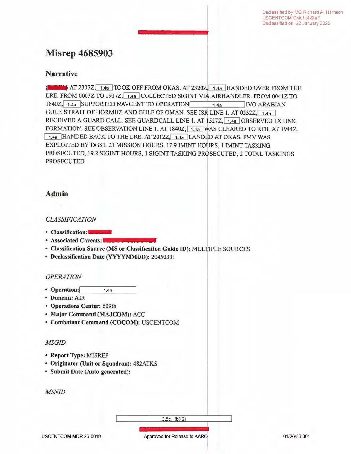
Page 1 shows the MISREP narrative and administration fields with USCENTCOM release/declassification markings and redacted mission details.
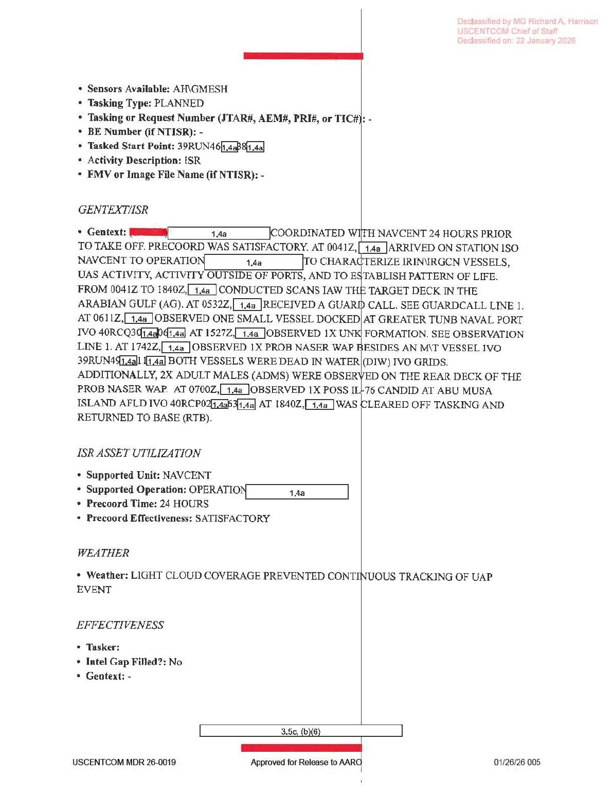
Page 5 shows the ISR narrative, NAVCENT support context, related activity lines, and the weather field that says light cloud coverage prevented continuous tracking of the UAP event.
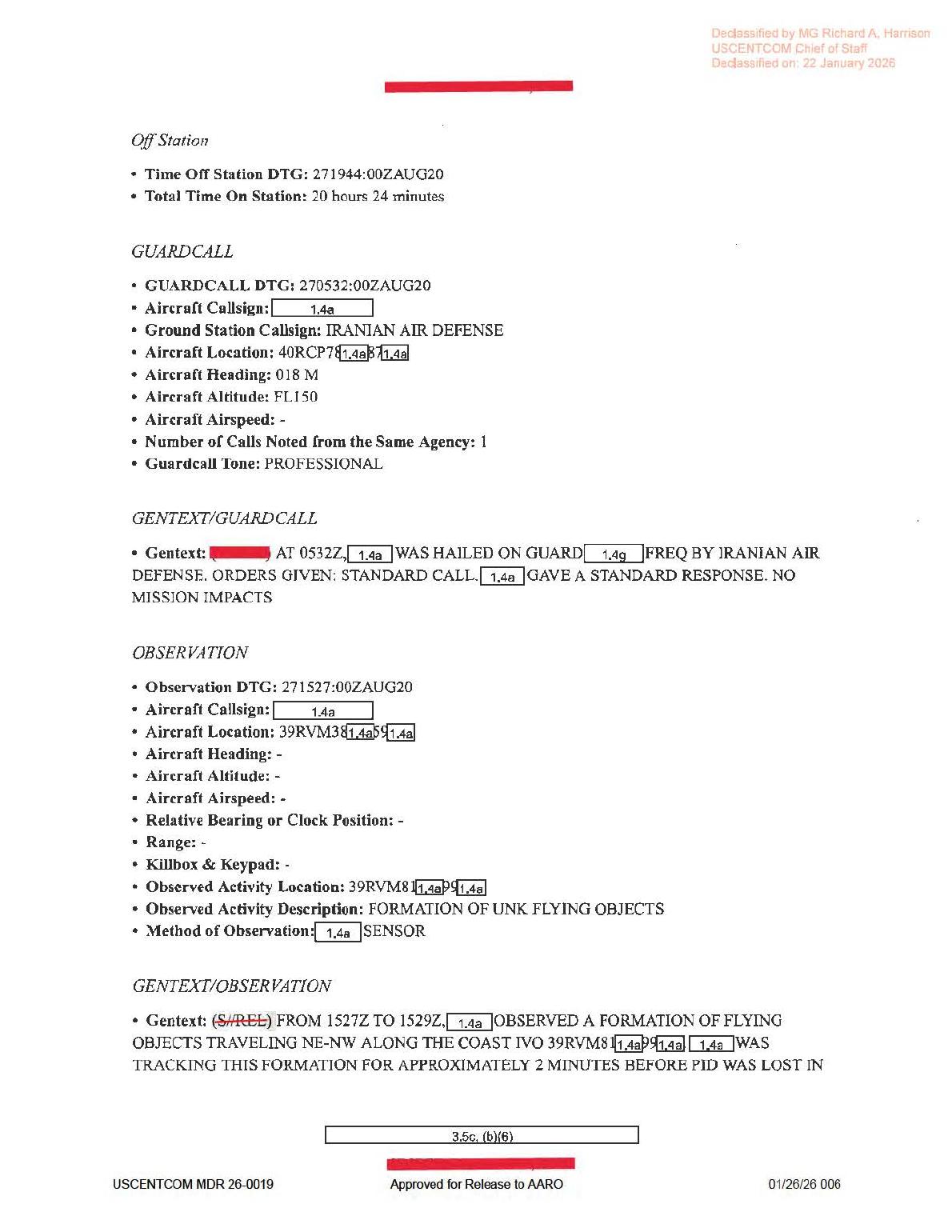
Page 6 shows the guardcall entry and the observation section that records a FORMATION OF UNK FLYING OBJECTS observed by a redacted sensor.
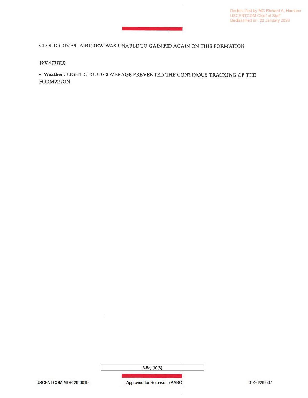
Page 7 continues the observation text, stating that cloud cover prevented the aircrew from regaining positive identification and prevented continuous tracking of the formation.
Investigation reading
This is a seven-page USCENTCOM Mission Report form for an August 2020 Arabian Gulf / Persian Gulf-region mission. The released PDF is text/form evidence only: every page is a scanned report page with redactions, and the rendered-page review did not show an object photograph, map, FMV still, radar plot, or other sensor image.
The main UAP-relevant entry appears on pages 6-7. The report states that at 271527:00ZAUG20, the aircrew observed a FORMATION OF UNK FLYING OBJECTS. The GENTEXT says that from 1527Z to 1529Z, a redacted platform observed a formation of flying objects traveling NE-NW along the coast near a partly redacted 39RVM... grid. The aircrew tracked the formation for approximately two minutes before positive identification was lost in cloud cover. Page 7 continues the sentence: CLOUD COVER. AIRCREW WAS UNABLE TO GAIN PID AGAIN ON THIS FORMATION, and its weather field says light cloud coverage prevented continuous tracking of the formation.
| Page | Reading notes |
|---|---|
| 1 | Narrative summary: takeoff from OKAS at 2307Z, LRE handover at 2320Z, SIGINT via AIRHANDLER from 0003Z to 1917Z, NAVCENT support from 0041Z to 1840Z, guard call at 0532Z, 1X UNK FORMATION at 1527Z, RTB at 1840Z, hand-back at 1944Z, landing at OKAS at 2012Z, and FMV exploited by DGSI. |
| 2 | Administrative tasking/contact page: mission type AREC, country tasked US - UNITED STATES, service tasked A - AIR FORCE, POC unit 482 ATKS, wing 432 AEW, and 609 CAOC / 12AF Det 3 PAROC workflow fields. |
| 3 | Equipment page: radar, RWR, MWS, IRCM, ECM, chaff/flare, towed-decoy, air-to-air missile, gun, and data-link fields are blank/dashed; air-to-ground weapons are redacted; target pod/designator is ANDAS4; additional avionics reads AH_GMESH. |
| 4 | Mission timeline: landing at OKAS at 272012:00ZAUG20, engine shutdown at 272022:00ZAUG20, takeoff at 262307:00ZAUG20, on-station at 262320:00ZAUG20, ISR from 270041:00ZAUG20 to 271840:00ZAUG20, primary sensor ANDAS4. |
| 5 | ISR narrative: support to NAVCENT to characterize IRIN/IRGCN vessels, UAS activity, activity outside ports, and pattern of life; scans in the Arabian Gulf target deck; 1X UNK FORMATION at 1527Z; weather line says light cloud coverage prevented continuous tracking of the UAP event. |
| 6 | Guardcall and observation page: Iranian Air Defense hails the aircraft on guard frequency at 0532Z; the observation entry records FORMATION OF UNK FLYING OBJECTS, method of observation as a redacted sensor, and the 1527Z-to-1529Z formation-tracking statement. |
| 7 | Continuation/weather page: cloud cover prevented positive identification from being regained and prevented continuous tracking of the formation. |
What the file appears to contain
The file appears to be a short operational MISREP, not a complete evidentiary package. It preserves the mission context, a redacted aircraft/platform and sensor context, a guard-call episode, routine maritime/airfield observations, and one narrow UAP observation line. The UAP line does not provide a released image, track plot, video frame, altitude, range, bearing, speed, shape, number of discrete objects beyond formation, or final identification.
The source-backed UAP details are limited but specific: 1X UNK FORMATION; observed activity description FORMATION OF UNK FLYING OBJECTS; observation DTG 271527:00ZAUG20; travel NE-NW along the coast; tracking for about two minutes; loss of PID in cloud cover; no mission impacts stated in the nearby guardcall/observation section. The method of observation is a redacted sensor. FMV was exploited by DGSI in the overall mission, and the report lists ANDAS4 as the primary sensor/target-pod designator, but the released PDF does not include the FMV product or any sensor frame of the formation.
The rendered text corrects several rough OCR readings from the stored text layer. The page image reads 2307Z takeoff, 2320Z LRE handover, 0003Z SIGINT start, 17.9 IMINT HOURS, 19.2 SIGINT HOURS, and 2 TOTAL TASKINGS PROSECUTED. The visible mission pages also read AH_GMESH, 272012:00ZAUG20 landing time, 262320:00ZAUG20 on-station time, 0041Z ISR arrival, IRIN/IRGCN vessel characterization, UAS ACTIVITY, and 1X POSS IL-76 CANDID at Abu Musa Island airfield. These corrections matter because the stored OCR can misread times, counts, and sensor/avionics labels.
Source custody and provenance
- Official source URL: WAR.GOV PDF
- Open Sky release-file route: open PDF
- Agency: Department of War
- Release: PURSUE Release 01
- Official CSV row tracked for this page:
67 - Source type: PDF, 7 pages, 877,324 bytes
- SHA-256:
4ce20fc566edf4a3dcb8a8abd7a5dcd91046069f9e35f83912ad757c8c8be1b9 - OCR coverage: 7 page markers with text on all 7 pages; rendered-page spot checks covered the high-signal pages and the administrative/equipment/timeline pages.
The official page title says DOW-UAP-D61, Mission Report, Arabian Gulf, August 2020, while the official file URL uses persian-gulf-august-2020. The embedded PDF metadata reports Title: DoW-UAP-D37 and Subject: DoW-UAP-D37, which appears inconsistent with the visible file title and official URL. Treat that as a provenance-cleanup lead, not as a reason to relabel the public page without source-record reconciliation.
Graph context
The graph has an exact Document record for the D61 PDF asset and a separate current-row source record for the Release 01 listing. It preserves 98 extracted claim records, 81 entity mentions, 6 sensor-event records, and 7 OCR page chunks plus surrounding source/manifest text. Those graph records are useful for navigation, but the public reading above is anchored to the rendered PDF page images and full OCR/text pass.
The sensor-event records should be read carefully. They include FMV, aircraft/platform mentions, an IR extraction tied to equipment wording, and form-field language around ANDAS4 / AH_GMESH. Page 3 has many radar/RWR/MWS/IRCM/ECM/weapon prompts, but those fields are blank or dashed; they are not released radar returns or raw instrument evidence. Page 6 says the method of observation was a redacted sensor, and page 1 says FMV was exploited by DGSI, but the released PDF itself does not publish the FMV clip or still frame.
Related graph navigation points include the D58 Range Fouler Debrief and D64 Mission Report / Iran record. No candidate crosslink should be treated as corroboration from this page alone; any related-record connection needs separate source-level review.
Leads to check
- Locate any associated FMV, still frame, or DGS/DGSI exploitation product for the
1527Zformation, if it was released or exists in another packet. - Reconcile the title/location variants: page title
Arabian Gulf, official URLPersian Gulf, body references to Arabian Gulf / Strait of Hormuz / Gulf of Oman, and the partly redacted39RVM...observation grid. - Reconcile metadata and row variants: embedded PDF metadata says
DoW-UAP-D37, while the visible source and release page are D61; one manifest-derived context may also need checking against the current row numbering. - Verify the redacted method of observation and whether
ANDAS4,AH_GMESH, FMV exploitation, or any external sensor record applies directly to the formation rather than only to the broader mission. - Check environmental/prosaic context for a two-minute coastal formation track lost in light cloud cover: weather, cloud layer, maritime/air traffic, UAS activity, IRIN/IRGCN vessel context, Abu Musa / Greater Tunb area activity, and camera/sensor limitations.
- Preserve OCR-quality notes: exact times and counts should be taken from the rendered page where OCR conflicts with the visible scan.
Lead check notes
- Blocked — associated media/source product: release metadata for this asset exposes the D61 PDF only, with no DVIDS URL, MP4 path, still image, or paired public video. Page 5 also leaves
FMV or Image File Name (if NTISR)as-, so any DGSI/FMV product for the1527Zformation remains outside the released file. - Partial — location and grid reconciliation: the visible source supports the Arabian Gulf / Persian Gulf-region mission framing, with body context for the Arabian Gulf, Strait of Hormuz, Gulf of Oman, Abu Musa, and Greater Tunb. The observation grid remains redacted; page-text extraction varies around the partial
39RVM...fields, so exact map placement needs an unredacted coordinate or a cleaner source image. - Partial — D61/D37 metadata tension: the verified PDF hash, official URL, release row, and visible title identify this as D61. The embedded PDF title/subject still read
DoW-UAP-D37, which remains a provenance-cleanup issue rather than evidence for a separate event. - Blocked — sensor-method detail: page 6 gives
Method of Observation: [redacted] SENSOR; page 3 listsANDAS4and additional avionics context, and page 1 says FMV was exploited, but the released PDF does not provide the sensor frame, raw track, or unredacted sensor label needed to tie those fields directly to the formation. - Needs external source — environmental and traffic checks: exact anchor searches in the current linked Release 01 OCR corpus found
FORMATION OF UNK FLYING OBJECTS,271527,39RVM, and the cloud-cover tracking language only in this D61 text. Weather, cloud layer, maritime/air traffic, UAS activity, and ordinary camera/sensor-limit checks require external operational or environmental records. - Checked — OCR/source-text quality: the new page renders confirm the main observation wording and show why OCR should be treated carefully. The PDF text layer supports
FROM 1527Z TO 1529Zand the source spellingCONTINOUS; other time, grid, and release-footer fields remain best handled as transcription-review items when the rendered page and OCR disagree.
Deep investigation — graph + web reconnaissance
Source reread
A fresh source pass confirms this is a seven-page redacted MISREP and not a released sensor-media exhibit. The verified PDF is 877,324 bytes with SHA-256 4ce20fc566edf4a3dcb8a8abd7a5dcd91046069f9e35f83912ad757c8c8be1b9; pdfimages shows one scanned page image per page and pdfdetach reports no embedded files. The PDF metadata still reads DoW-UAP-D37, while the visible title, WAR.GOV file URL, release row, and hash identify this public asset as D61.
Rendered-page and text-layer rereads tighten the key source facts. Page 1 supports 2307Z OKAS takeoff, 2320Z LRE handover, SIGINT via AIRHANDLER from 0003Z to 1917Z, NAVCENT support from 0041Z to 1840Z, 1X UNK FORMATION at 1527Z, 2012Z OKAS landing, FMV WAS EXPLOITED BY DGS1, 17.9 IMINT HOURS, 19.2 SIGINT HOURS, and 2 TOTAL TASKINGS PROSECUTED. Page 5 says the release exposes no FMV/image filename and gives the weather note: LIGHT CLOUD COVERAGE PREVENTED CONTINUOUS TRACKING OF UAP EVENT. Page 6 gives the observation DTG 271527:00ZAUG20, partial redacted 39RVM... location fragments, Observed Activity Description: FORMATION OF UNK FLYING OBJECTS, and Method of Observation: [redacted] SENSOR. Page 7 completes the sentence: cloud cover prevented the aircrew from regaining PID and prevented CONTINOUS tracking of the formation. Those page images support the corrected times and source spelling better than the noisier frontier OCR.
Graph connections
The graph has two official-primary D61 records: the current Release 01 row record for CSV row 67, and the exact PDF asset record keyed to the WAR.GOV PDF URL and the SHA-256 above. The asset has 9 TextChunk links, 98 machine-extracted Claim records, 81 EntityMention records, and 6 SensorEvent records. All 98 claim nodes remain machine_extracted_needs_human_review; the useful ones mirror the source's formation of unknown flying objects, 1527Z, cloud-cover, FMV, and sensor-language cues, but they are not independent corroboration.
The 6 sensor-event nodes are also machine cues, not released sensor returns. They include FMV, IR, and unknown modalities derived from words in the report and equipment fields. Page 3's radar/RWR/MWS/IRCM/ECM prompts are blank or dashed, and page 5 leaves FMV or Image File Name (if NTISR): -; so the public record supports only a redacted-sensor observation statement and broader mission FMV exploitation, not a public radar plot, raw FMV clip, or confirmed IR frame for the formation.
Graph relationship checks did not surface any CANDIDATE_CROSSLINK for this asset. Direct document links include the current D61 manifest row and a non-current row/URL drift link involving D64 that should be treated as manifest-cleanup context, not a second corroborating source. A secondary UFO-USA GitHub markdown conversion exists for the same official asset, but it is a derived mirror lead; the WAR.GOV PDF and release metadata remain the source of record.
External provenance and official-source checks
The cached official-primary PDF and release CSV row agree on the public title, agency, incident date 8/27/20, incident location Arabian Gulf, blank video/DVIDS pairing fields, and the description of a formation traveling northeast to northwest for about two minutes before tracking was lost in light cloud cover. Direct live requests to the WAR.GOV PDF, WAR.GOV landing page, and WAR.GOV CSV returned 403 Access Denied from this environment, which is consistent with the current custody/access behavior seen across Release 01 files; it does not override the verified official-primary cached bytes and hash. Internet Archive exact-URL checks were rate-limited or unavailable during this pass, and Defense.gov/AARO searches also returned access-denied responses. A DVIDS web search for the D61 title did not return a usable public pairing, matching the release row's blank DVIDS/video fields.
Prosaic checks and limits
The first prosaic lane is already in the source: light cloud cover ended positive identification and continuous tracking. The same mission context also includes NAVCENT target-deck scans, IRIN/IRGCN vessel characterization, UAS activity, Abu Musa airfield activity, and a guard call from Iranian Air Defense; those are operational context, not proof that any one item explains the formation. Exact-date graph probes for modeled LaunchEvent and AstronomyEvent records on 2020-08-27 returned no direct graph hits, but without the unredacted location, look direction, elevation, platform, sensor mode, and raw timing, that absence is only a graph-coverage note, not an exclusion.
Weather, maritime/air traffic, satellite, launch, balloon/UAS, and camera/sensor artifact checks remain blocked by missing source material: the released PDF gives no raw FMV/still, full coordinate, bearing, range, altitude, speed, platform geometry, sensor settings, or external track data. No finding or resolution is implied here; the strongest current assessment is that D61 is a source-backed but under-instrumented two-minute formation report whose public evidence is limited to redacted text and derived page renders.
Follow-up leads
- Obtain any DGS1/DGSI exploitation product, raw FMV, still frame, or source packet for the
1527Zobservation if a future release exposes it. - Reconcile the D61/D37 embedded-metadata mismatch and the D64 non-current relationship in the manifest/graph layer without treating either as a new event.
- Pin the redacted
39RVM...grid and coast segment before running meaningful weather, traffic, satellite, balloon/UAS, or maritime-correlation checks. - Preserve the source spelling and uncertainty (
UNK,CONTINOUS, redacted sensor label, and partial grid strings) when quoting the report.
Audit note
This section is based on the verified release-file copy, rendered page review, OCR/text-layer comparison, read-only graph queries, and bounded official-source web reconnaissance. It adds context and provenance checks only; it does not create a finding, hypothesis, or resolution decision.
Limits
This draft does not identify the formation and does not assert a finding. The released source is a redacted text/form MISREP. It does not provide a released image of the objects, a radar plot, a flight track, a full sensor transcript, a complete MGRS coordinate, or unredacted platform details. The page records what the source says and what the graph currently models, but the observation still needs source-level follow-up and human review before any analytical conclusion.
Sources
- Department of War / WAR.GOV,
DOW-UAP-D61, Mission Report, Arabian Gulf, August 2020, official PDF URL: https://www.war.gov/medialink/ufo/release_1/dow-uap-d61-mission-report-persian-gulf-august-2020.pdf - Open Sky release-file copy for this asset:
/api/explore/war-gov/release-file/war-gov-dow-uap-d61-mission-report-arabian-gulf-august-2020-a33faf4c - Open Sky Release 01 graph/OCR records for the same SHA-256:
4ce20fc566edf4a3dcb8a8abd7a5dcd91046069f9e35f83912ad757c8c8be1b9