DOW-UAP-D62, Mission Report, Strait of Hormuz, September 2020
Evidence media
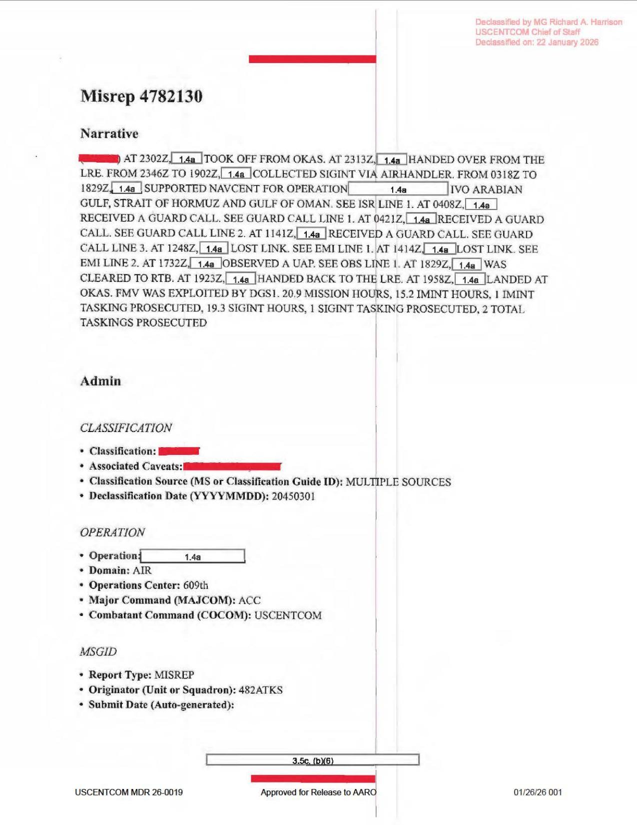
Page 1 is a derived render from the official PDF. It shows the MISREP narrative and admin fields for mission 4782130, including visible times for NAVCENT support, guard calls, lost-link entries, and a UAP observation at 1732Z; it is not object imagery, a map, a radar plot, or a sensor frame.
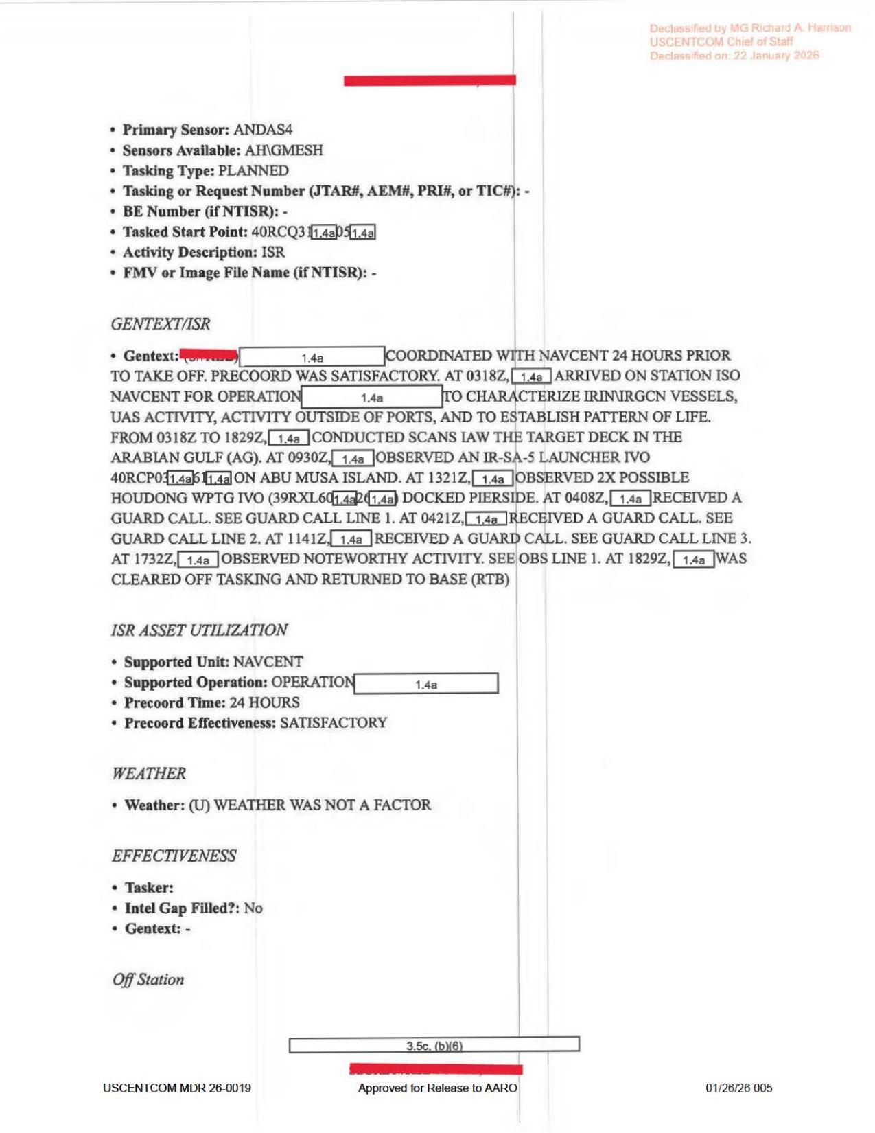
Page 5 is a derived render from the official PDF. It shows ISR source fields including ANDAS4, AH\GMESH, NAVCENT support, target-deck context, FMV or Image File Name: -, and (U) WEATHER WAS NOT A FACTOR; it is source-document context, not object imagery.
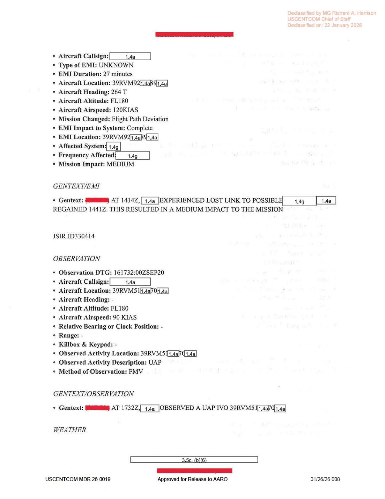
Page 8 is a derived render from the official PDF. It shows an EMI/lost-link entry and the JSIR ID330414 OBSERVATION block with 161732:00ZSEP20, aircraft altitude FL180, aircraft airspeed 90 KIAS, observed activity description UAP, and method of observation FMV; it is not the FMV itself or a still frame from it.
Investigation reading
This released file is a nine-page USCENTCOM mission report packet, not an imagery packet. The visible pages are scanned text/form pages with redactions, declassification stamps, and form fields. The packet records a NAVCENT-support mission in the Arabian Gulf / Strait of Hormuz / Gulf of Oman operating area and contains one formal observation entry for a UAP at 161732:00ZSEP20.
The most important reading sequence is page 1 for the mission narrative, page 5 for the ISR narrative, pages 7-8 for the EMI/lost-link entries, and page 8 for the UAP observation line. Rendering all nine pages showed no object photograph, map, radar plot, sensor still, FMV frame, diagram, or visual exhibit. The report says the method of observation was FMV, but the released PDF does not include the video or a frame from it.
The rendered pages correct several OCR rough edges. Page 1 reads 2313Z handover, 0318Z to 1829Z NAVCENT support, 1248Z lost link, 1732Z observed a UAP, 20.9 mission hours, 15.2 IMINT hours, and 19.3 SIGINT hours. Page 5 reads AH/GMESH, 0318Z, 0930Z, and 1321Z where the OCR can drift toward AH/GMISH, 0118Z, 0906Z, or 1331Z.
What the file appears to contain
| Page(s) | Content read | Notes for investigation |
|---|---|---|
| 1 | MISREP narrative and admin/classification fields. | Mission took off from OKAS at 2302Z, handed over from LRE at 2313Z, collected SIGINT via AIRHANDLER from 2346Z to 1902Z, supported NAVCENT from 0318Z to 1829Z, recorded guard calls at 0408Z, 0421Z, and 1141Z, recorded lost-link events at 1248Z and 1414Z, observed a UAP at 1732Z, returned to base at 1829Z, handed back at 1923Z, and landed at OKAS at 1958Z. It also says FMV was exploited by DGSI. |
| 2 | Mission ID, POC, QC, and approver fields. | Administrative/personnel details are heavily redacted. Mission type is AREC; country tasked is United States; service tasked is Air Force. |
| 3 | Aircraft/equipment form fields. | Radar, RWR, MWS, IRCM, ECM, chaff/flare, towed-decoy, and weapon fields are blank or dashed. Target pod is rendered as ANDAS4; additional avionics as AH/GMESH. These form labels should not be mistaken for raw sensor returns. |
| 4 | Timeline fields. | Landing/takeoff/on-station/ISR times align with the page 1 narrative: takeoff from OKAS, on-station around 152313:00ZSEP20, ISR from 160318:00ZSEP20 to 161829:00ZSEP20, landing at 161958:00ZSEP20, engine shutdown at 162008:00ZSEP20. |
| 5 | ISR line and GENTEXT/ISR. | Primary sensor is ANDAS4; sensors available are AH/GMESH; FMV/image filename field is -. The narrative says the mission characterized IRIN/IRGCN vessels, UAS activity, activity outside ports, and pattern of life. It notes an IR-SA-5 launcher near Abu Musa Island at 0930Z, two possible Houdong WPTG docked pierside at 1321Z, and 1732Z “noteworthy activity” pointing to OBS Line 1. Weather was not a factor. |
| 6-7 | Guard-call records and the first EMI event. | Three Iranian Air Defense guard calls are recorded; the third uses guard 243.000 and is marked professional. The first EMI event starts 161248:00ZSEP20, ends 161259:00ZSEP20, type unknown, duration 11 minutes, aircraft altitude FL180, airspeed 89 KIAS, mission changed by flight-path deviation, impact medium, and link regained at 1259Z (JSIR ID330412). |
| 8 | Second EMI continuation and formal UAP observation. | The second EMI event has a 27-minute duration, aircraft heading 264 T, altitude FL180, airspeed 120 KIAS, medium mission impact, and link regained at 1441Z. The UAP observation is JSIR ID330414: observation DTG 161732:00ZSEP20; aircraft/observed-activity location begins 39RVM51 with redactions; aircraft altitude FL180; airspeed 90 KIAS; bearing, range, and killbox fields are dashed; observed activity description is UAP; method of observation is FMV; gentext says that at 1732Z a redacted reporter observed a UAP in the vicinity of the partly redacted 39RVM51 location. |
| 9 | Weather continuation and footer. | Page 9 only visibly carries the weather continuation: (U) WEATHER WAS NOT A FACTOR, plus redactions and release markings. |
The released source therefore supports a narrow reading: this is a text/form MISREP that reports one UAP observation during a broader NAVCENT ISR mission, with FMV listed as the observation method. It does not provide the FMV itself, a still image, a radar track, a map, a range/bearing value, or visible object morphology beyond the form label UAP.
Source custody and provenance
- Official/source URL: https://www.war.gov/medialink/ufo/release_1/dow-uap-d62-mission-report-strait-of-hormuz-september-2020.pdf
- Open Sky release-file route: war-gov-dow-uap-d62-mission-report-strait-of-hormuz-september-2020-b8b5b17a
- SHA-256:
36708d3c6121b00c55394ac4a648fbcbe5411c8b2c00ea8f42f9ca0e502c6b13 - Verified source size:
1,045,437bytes; PDF page count:9; OCR coverage:9 / 9pages with text. - Official release row used for this page:
68; the release title gives “Strait of Hormuz, September 2020,” while the report body places the mission in the Arabian Gulf / Strait of Hormuz / Gulf of Oman operating area on16SEP20DTGs. - The PDF metadata title/subject reads
DoW-UAP-D38, while the official URL, release title, hash, and visible page content identify this item asDOW-UAP-D62. Treat that as a provenance-cleanup lead, not as a reassignment. - A byte-range check of the official PDF returned
206with total length1,045,437, matching the verified released file size.
Graph context
Open Sky currently models this item as an official primary-source PDF asset and a paired release-record node. The semantic layer preserves 134 extracted claims, 114 entity mentions, 15 sensor-event records, and no table rows for this asset.
Those graph records are useful navigation aids, but they need careful reading against the page images. Some sensor-event records are source-backed in a limited way: the document states FMV was exploited by DGSI, lists ANDAS4 and AH/GMESH in the ISR/equipment context, and marks the UAP observation method as FMV. Other sensor-looking terms come from blank or dashed form prompts, such as radar/RWR/MWS/IRCM/ECM fields on page 3, and should not be treated as released radar, RWR, IR, or electronic-warfare evidence without a populated source field.
The report also contains EMI/lost-link events at 1248Z and 1414Z. They are adjacent in the same mission report, but the released text does not establish that either EMI event caused, explained, or was caused by the later 1732Z UAP observation. The safer graph reading is: same mission packet, separate event lines, all needing human review before any case-level interpretation.
Related WAR.GOV records in the graph include other Arabian Gulf / Strait of Hormuz mission-report items such as D6 and D65. Those links should be treated as release-corpus navigation unless a human review establishes shared incident identity, platform continuity, or source-chain dependency.
Leads to check
- Locate any released or unreleased FMV, DVIDS item, still frame, or sensor extract corresponding to
JSIR ID330414and the161732:00ZSEP20observation. The PDF names FMV as the method, but does not provide the visual media. - Reconcile the official manifest sentence that describes “one UAP at an estimated altitude of 1,800 feet” with the rendered observation page, which visibly lists the aircraft altitude as
FL180and does not show a separate unredacted UAP-altitude field. - Correct OCR-derived fields in the graph where the rendered page is clearer:
482ATKS,AH/GMESH,0318Z,0930Z,1321Z,IR-SA-5,Houdong WPTG,1248Z,89 KIAS,120 KIAS, and20.9mission hours. - Keep the ISR target-deck observations separate from the UAP line. The IR-SA-5 launcher, possible Houdong WPTG, IRIN/IRGCN vessels, and UAS-activity references are mission context, not the UAP observation itself.
- Review whether the D62/D65/D6 relationships are simple release-neighbor links or indicate a meaningful shared operational cluster.
- Preserve the
DoW-UAP-D38embedded PDF metadata mismatch as a release-file/provenance cleanup item.
Lead check notes
- Checked — released media scope: The verified Release 01 record for row
68exposes this PDF, not a paired DVIDS video, MP4, still image, map, or radar plot. The PDF has no embedded file attachments, and its image inventory is page-scan imagery; the media added above are derived renders of the official PDF pages, not object photographs or FMV frames. - Partial — FMV /
JSIR ID330414trail: Page 1 says FMV was exploited, and page 8 lists theJSIR ID330414observation method asFMVat161732:00ZSEP20. Page 5 still showsFMV or Image File Name: -, and the release metadata checked here does not provide a paired video or still frame; frame-level review needs the underlying FMV, a JSIR package, or another authoritative source. - Partial — manifest altitude wording: The release description says a U.S. military operator reported one UAP at an estimated altitude of
1,800 feet, but the page-8 source-document field visibly lists aircraft altitudeFL180and does not expose a separate unredacted UAP-altitude field. That mismatch should stay a manifest/source-history lead until the source behind the release description is compared. - Checked — OCR/source-field corrections: Page renders and selectable text support
482ATKS,AN/DAS4/ANDAS4,AH\GMESH,0318Z,0930Z,1321Z,IR-SA-5,Houdong WPTG,1248Z,89 KIAS,120 KIAS, and20.9mission hours. Page 8 also favors MGRS-style fragments beginning39RVM...; older OCR strings such as398VM...,AH/GMISH,IR-A5-5, or shifted times should be treated as extraction quality issues, not alternate source values. - Partial — D62/D65/D6 relationship: Exact Release 01 OCR searches found
JSIR ID330414,161732:00ZSEP20, and1732Zconfined to D62. D6 is a different, much more redacted1246Zprobable-UAP page, and D65 is a July 2020 Arabian Gulf packet with multiple observations that still needs page-level review; these are useful navigation leads, not a proven shared event. - Needs external source — prosaic/environment checks: The PDF gives only redacted coordinates, no range/bearing, no UAP morphology, no frame, no full FMV, no flight track, and no raw weather/traffic/astronomy/satellite data. Those sources are required before ordinary aircraft, drone, vessel, astronomy, weather, or sensor-artifact checks can go beyond source-reading.
- Checked — ISR context separation: The
IR-SA-5launcher, possibleHoudong WPTG, IRIN/IRGCN vessel, UAS-activity, guard-call, and EMI/lost-link lines are real mission-context entries in the same packet, but the released text does not establish that any of them caused, explained, or were caused by the later1732ZUAP observation.
Deep investigation — graph + web reconnaissance
Source reread
- The verified official-primary PDF copy is a nine-page, copy-restricted scan set:
1,045,437bytes, SHA-25636708d3c6121b00c55394ac4a648fbcbe5411c8b2c00ea8f42f9ca0e502c6b13.pdfimagesinventories one page-image per page plus tiny inline stencils; it does not expose an embedded FMV, still frame, map, radar plot, telemetry attachment, or object photograph. - Visual reread of the key page renders tightens the OCR. Page 1 supports
482ATKS,2313ZLRE handover,0318Z-1829ZNAVCENT support,1732ZUAP observation,FMV was exploited by DGS1,20.9mission hours,15.2IMINT hours, and19.3SIGINT hours. Page 5 supportsANDAS4/AN/DAS4, visually ambiguousAHNGMESHsensor text,FMV or Image File Name: -,IR-SA-5,Houdong WPTG,0318Z,0930Z,1321Z, and(U) WEATHER WAS NOT A FACTOR. Page 8 supportsJSIR ID330414, observation DTG161732:00ZSEP20, aircraft/observed-activity coordinate fragments beginning39RVM51, aircraft altitudeFL180, airspeed90 KIAS, dashed bearing/range/killbox fields, observed activity descriptionUAP, and method of observationFMV. - The release-description sentence about an estimated
1,800 feetUAP altitude remains a custody/manifest tension. The visible observation block exposes aircraft altitudeFL180; it does not show a separate unredacted UAP-altitude field. The redacted39RVM...strings are MGRS-style fragments only, not full coordinates suitable for geolocation.
Graph reconciliation
- Neo4j has an exact official asset match by URL and full-file hash, plus current Release 01 record linkage. The asset node carries
9OCR pages with text and the same1,045,437-byte /36708d3c...hash. The semantic layer currently preserves134machine-extractedClaimnodes,114EntityMentionnodes, and15SensorEventnodes for this source asset; all are review aids, not findings. - Several graph records still show release-manifest drift around D6/D62/D65. The current D62 row record is row
68, but a stale D6 final-URL/body-hash can appear on that row record; nearby D65 row71can carry the D62 PDF hash or manifest-description row marker. For case work, use the exact D62 title, official PDF URL, and SHA-256 above as the stable identity anchors, not neighboring row relationships. - The
SensorEventnodes mix source-supported cues with extraction noise. Source-supported cues include FMV exploitation, the page-8Method of Observation: FMV, guard-call records, and EMI/lost-link lines. Radar/RWR/MWS/IRCM/ECM/IR-looking entries from blank form prompts or target-deck terms should not be promoted to released sensor evidence. - One audit-only
CANDIDATE_CROSSLINKappears via a stale row-record path to a broad “High Strangeness” document index using the shared phraseStrait Of Hormuzand score0.5. Its own relationship metadata marks it ascandidate_crosslink_needs_human_review/not_a_finding; it is not provenance equivalence, event identity, causality, or corroboration. The UFO-USA Markdown conversion is likewise a derived secondary copy, useful only for comparison against the official PDF.
Official-source and web reconnaissance
- Live official WAR.GOV probes for the PDF, CSV, landing page, thumbnail, and press-release page returned
403during this check; that is an access/custody condition, not a contradiction of the cached official-primary PDF, because the Open Sky release-file copy still hash-matches the official URL record. - The graph source record preserves the Release 01 landing/CSV spine and the official press-release title
Department of War Releases Unidentified Anomalous Phenomena Files in Historic Transparency Effort, with release date2026-05-08,158CSV records,116PDF URLs,28video URLs, and14image URLs modeled for the release. Current DVIDS search returned an empty202response, and live Defense.gov/AARO searches returned403; no public paired FMV or still frame forJSIR ID330414surfaced in this pass. - Internet Archive availability for the exact PDF URL returned
429during this check. That leaves official live re-fetch, archived CSV/PDF replay, and any future DVIDS/AARO publication as follow-up provenance work rather than current corroboration.
Prosaic checks and open questions
- The source itself says weather was not a factor, but the release does not provide unredacted coordinates, range, bearing, sensor field of view, platform track, raw FMV, or object morphology. Exact graph probes found no modeled
LaunchEventorAstronomyEventon2020-09-16, and no launch entry in a narrow2020-09-14to2020-09-19graph window; those are graph-coverage checks, not external exclusions. - The first prosaic lanes remain ordinary maritime/air/UAS traffic in a NAVCENT ISR target-deck environment, sensor/display/compression artifacts in the unreleased FMV, and mission-system context around the two earlier lost-link/EMI events. The released text does not establish that the guard calls, target-deck observations, or EMI events caused or explained the later UAP observation.
- Follow-up should seek the underlying FMV or JSIR package for
ID330414, unredacted39RVM51...location geometry, raw weather/traffic/satellite context, and an official explanation for the1,800 feetmanifest wording versus the visibleFL180aircraft-altitude field.
Audit note
This section is a source/graph/web reconnaissance update only. No Neo4j writes, finding nodes, hypothesis nodes, or resolution decisions were created; machine-extracted graph material remains machine_extracted_needs_human_review / not_a_finding unless directly verified against the source pages above.
Limits
This draft is not a finding, identification, or resolution. The released file is heavily redacted and text-only. It supplies no object image, no map, no radar plot, no raw FMV, no range, no relative bearing, no killbox/keypad, and no visible object description beyond UAP. The coordinates are partly redacted, and redaction-exemption labels inside coordinate strings should not be read as original coordinate characters.
The report records one formal UAP observation and several other mission-context events in the same packet. It does not by itself establish whether the UAP was anomalous, prosaic, misidentified, related to the EMI events, related to the Iranian guard calls, or related to any other Release 01 item.
Sources
- Department of War / WAR.GOV, PURSUE Release 01 PDF: DOW-UAP-D62, Mission Report, Strait of Hormuz, September 2020
- Open Sky release-file copy for this asset: /api/explore/war-gov/release-file/war-gov-dow-uap-d62-mission-report-strait-of-hormuz-september-2020-b8b5b17a
- WAR.GOV Release 01 CSV row
68and Open Sky Release 01 graph records forDOW-UAP-D62.