DOW-UAP-D64, Mission Report, Iran, November 2020
Evidence media
Derived page renders from the official PDF:
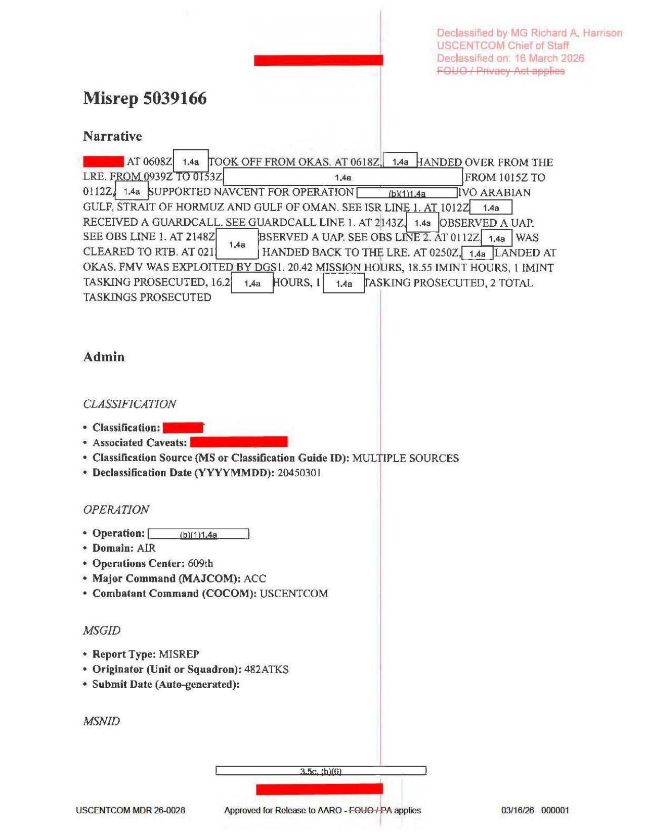
Page 1 is the mission narrative/admin page. It shows the source timeline for OKAS takeoff, LRE handoff, NAVCENT support, the 1012Z guardcall, the two UAP observation lines at 2143Z and 2148Z, RTB/landing, and the statement that FMV was exploited by DGS1.
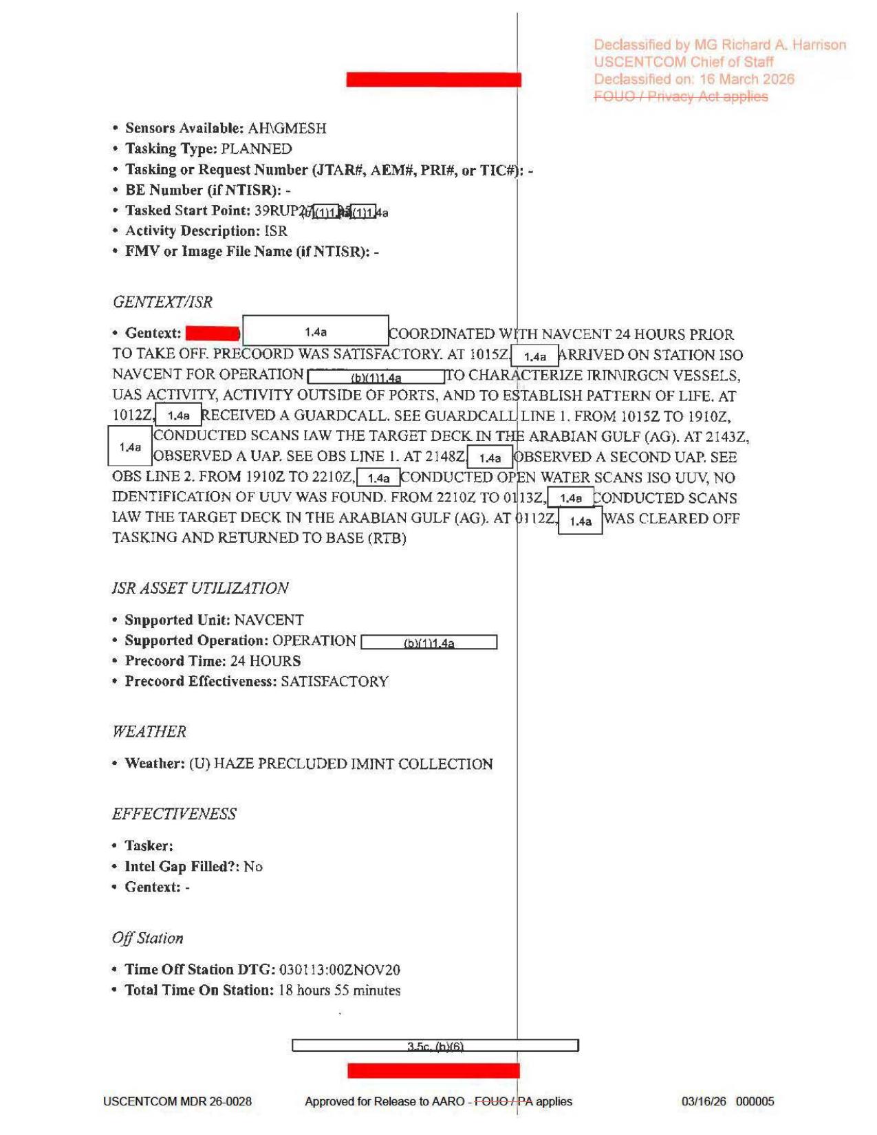
Page 5 is the ISR GENTEXT page. It preserves the NAVCENT tasking context, the 1015Z-1910Z and 2210Z-0113Z target-deck scan windows, the 2143Z / 2148Z UAP references, the blank FMV or Image File Name field, and the weather note that haze precluded IMINT collection.
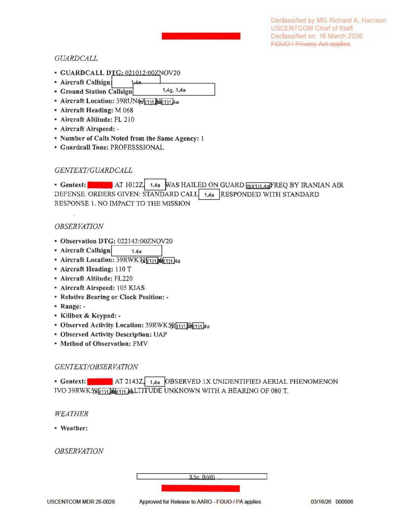
Page 6 is the guardcall plus first observation page. The visible source text shows the 1012Z Iranian Air Defense guardcall, then Observation Line 1 at 022143:00ZNOV20, aircraft heading 110 T, altitude FL220, airspeed 105 KIAS, method FMV, and a partly redacted 39RWK... observed-activity location.
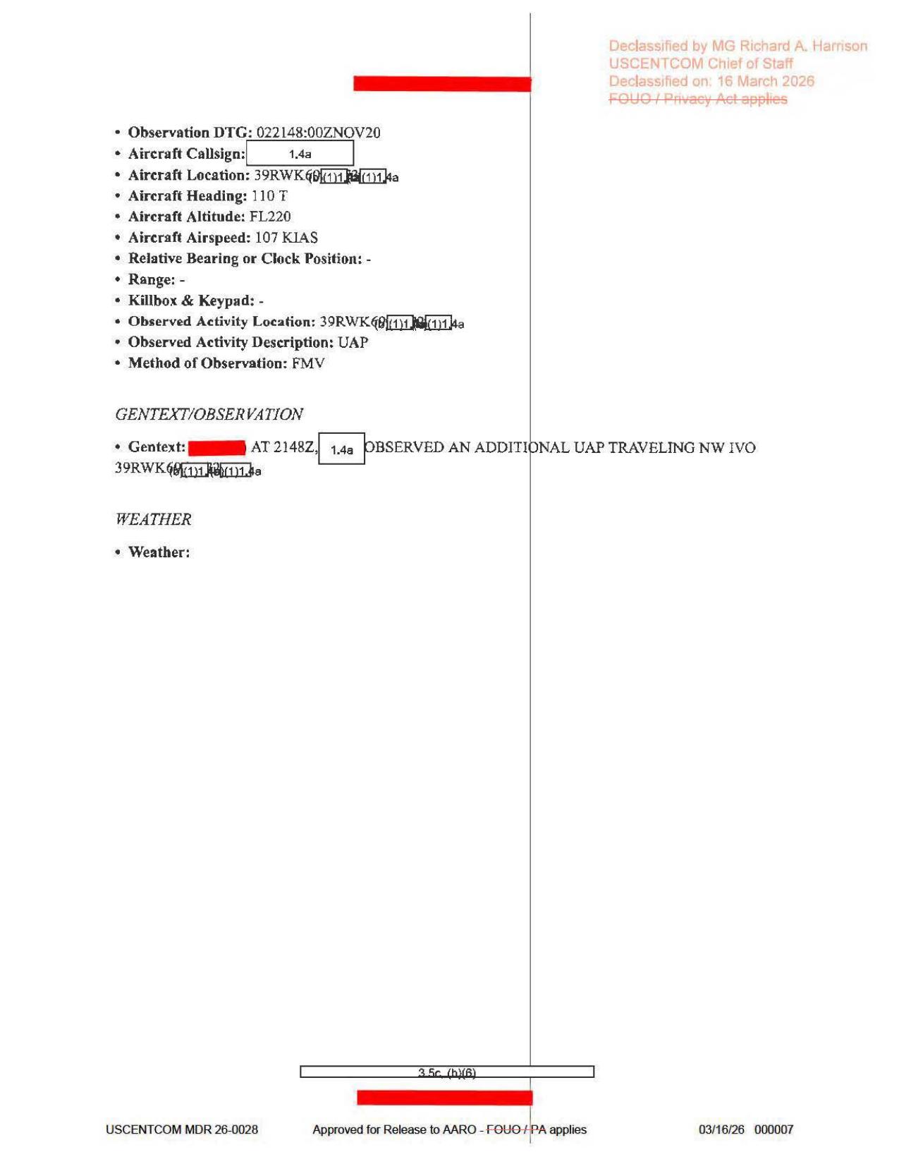
Page 7 is the second observation page. It shows Observation Line 2 at 022148:00ZNOV20, heading 110 T, altitude FL220, airspeed 107 KIAS, method FMV, and GENTEXT stating that an additional UAP was observed traveling northwest in the vicinity of a partly redacted 39RWK... location. These are source-document page renders, not object imagery or FMV frames.
Investigation reading
This page is a source-level reading of a seven-page Department of War Release 01 MISREP packet. The released PDF was checked as a 860,506-byte file with SHA-256 8422fceb10b2eafcab525690cc9aff6827fc78d5ae5e34b44174d9cc78abbb7c; the file reports seven pages and the Release 01 OCR has text for all seven.
The packet is best read as a short operational form report, not as an imagery exhibit. Rendered-page review shows typed MISREP pages, redactions, form fields, and release markings only. There are no embedded object photographs, maps, radar plots, FMV stills, target-pod frames, or sensor-display images in the released PDF. The source text records two UAP observation entries on 2 November 2020, with FMV listed as the method of observation, but the underlying FMV itself is not present in this file.
What the file appears to contain
The release title and CSV row identify the asset as DOW-UAP-D64, Mission Report, Iran, November 2020. The body of the MISREP places the mission in the Arabian Gulf / Strait of Hormuz / Gulf of Oman area in support of NAVCENT. The UAP entries appear in a broader mission narrative that also mentions Iranian Air Defense guardcall traffic, characterization of IRIN/IRGCN vessels and UAS activity, open-water scans for UUV activity, and return-to-base events.
| Page | Source reading |
|---|---|
| 1 | Narrative/admin page. The rendered page reads takeoff from OKAS at 0608Z, handover from the LRE at 0618Z, NAVCENT support in the Arabian Gulf / Strait of Hormuz / Gulf of Oman, a guardcall at 1012Z, UAP observations at 2143Z and 2148Z, clearance to RTB at 0112Z, landing at OKAS at 0250Z, and FMV WAS EXPLOITED BY DGS1. It lists 20.42 mission hours and rendered text supports 18.55 IMINT hours. |
| 2 | Administrative tasking/contact page. Visible fields include tasking order EX, mission type AREC, country tasked US - UNITED STATES, service tasked A - AIR FORCE, POC unit 482 ATKS / wing 432 AEW, QC unit 12 AF PAROC, and approver wing 379 AEW / 609 CAOC. Personal details are redacted. |
| 3 | ACEQUIP form page. Most radar/RWR/MWS/IRCM/ECM/CMD/weapon prompts are blank or dashed. Populated equipment context includes target pod/designator ANDAS4 and additional avionics AH_GMESH_VORTEX; the air-to-ground weapons field is withheld by a 1.4(a) marking. The dashed radar/RWR/weapon prompts should not be treated as raw sensor evidence. |
| 4 | Timeline page. Rendered text gives last land location OKAS, last land time 030250:00ZNOV20, engine shutdown 030300:00ZNOV20, total mission time 20 hours 42 minutes, takeoff time 020608:00ZNOV20, on-station time 020618:00ZNOV20, ISR time-on 021015:00ZNOV20, ISR time-off 030115:00ZNOV20, mission type AREC, and primary sensor ANDAS4. |
| 5 | ISR GENTEXT page. The mission coordinated with NAVCENT 24 hours prior to takeoff, arrived on station at 1015Z, characterized IRIN/IRGCN vessels, UAS activity, activity outside ports, and pattern-of-life. It records target-deck scans from 1015Z to 1910Z, a first UAP at 2143Z, a second UAP at 2148Z, open-water scans from 1910Z to 2210Z with no UUV identification found, additional Arabian Gulf scans from 2210Z to about 0113Z, and RTB clearance at 0112Z. Weather line: haze precluded IMINT collection. |
| 6 | Guardcall and first observation page. The guardcall entry is 021012:00ZNOV20, aircraft heading M 068, altitude FL 210, tone professional, and the text says the aircraft was hailed on guard frequency by Iranian Air Defense, used the standard response, and reported no mission impact. The first UAP observation is 022143:00ZNOV20; rendered text shows heading 110 T, altitude FL220, airspeed 105 KIAS, observed activity description UAP, method FMV, and GENTEXT: at 2143Z, one unidentified aerial phenomenon was observed in the vicinity of a partly redacted 39RWK... grid, altitude unknown, bearing 080 T. |
| 7 | Second observation page. The second UAP observation is 022148:00ZNOV20; rendered text shows aircraft heading 110 T, altitude FL220, airspeed 107 KIAS, observed activity description UAP, method FMV, and GENTEXT: at 2148Z, an additional UAP was observed traveling northwest in the vicinity of a partly redacted 39RWK... grid. Weather is blank. |
The main source-reading correction is that earlier OCR/graph extraction mixed variants such as 2142Z, 2149Z, 2134Z, 2146Z, FL250, and FL230. The rendered pages and selectable text support 2143Z and 2148Z as the observation times, with the observation pages reading FL220 for both UAP entries. The release description also says 2143Z and 2148Z.
Source custody and provenance
- Official URL: https://www.war.gov/medialink/ufo/release_1/dow-uap-d64-mission-report-iran-november-2020.pdf
- Open Sky release-file route: war-gov-dow-uap-d64-mission-report-iran-november-2020-2fecc4f3
- SHA-256:
8422fceb10b2eafcab525690cc9aff6827fc78d5ae5e34b44174d9cc78abbb7c - File size:
860,506bytes - Page count:
7 - Release record: CSV row
70, agencyDepartment of War, release titleDOW-UAP-D64, Mission Report, Iran, November 2020, incident date11/2/20, incident location fieldIran. - Embedded PDF metadata reports title/subject
DoW-UAP-D40, while the official URL, release record, and visible release title are D64. That mismatch should be handled as a custody/metadata cleanup lead, not as a reassignment of the asset.
Graph context
The Open Sky graph has an official release-record document for CSV row 70 and a separate PDF-asset document for this file. The semantic extraction currently preserves 109 source-text claims, 89 entity mentions, and 7 sensor-event records. Those records are useful navigation aids, but they should remain subordinate to the rendered source pages for high-signal fields.
The source-backed sensor context is narrow: page 1 says FMV was exploited by DGS1; pages 6 and 7 list Method of Observation: FMV; page 4 and page 3 identify ANDAS4 as the primary sensor / target pod, with AH_GMESH_VORTEX as additional avionics. By contrast, page 3's radar, RWR, MWS, IRCM, ECM, decoy, and weapon lines are mostly dashed form prompts. Graph sensor events created from those labels should be treated as form-navigation cues, not as evidence that radar, RWR, IR missile warning, or electronic-warfare systems produced a UAP return.
The graph also surfaces a candidate crosslink involving the phrase Arabian Gulf and related Release 01 records such as D61 and D74. Those are review leads only. This draft does not assert that D64 is the same event as any related document.
Leads to check
- Reconcile the official D64 title/location fields with the body text: the release row says
Iran, while the mission narrative emphasizes the Arabian Gulf, Strait of Hormuz, Gulf of Oman, NAVCENT, and Iranian Air Defense. - Track the embedded PDF metadata mismatch (
DoW-UAP-D40) against the official D64 URL/title and the Release 01 inventory. - Review whether any associated DGS1 FMV, stills, mission products, or AARO attachments exist outside this PDF. The released PDF references FMV but does not include the video or a sensor frame.
- Preserve the OCR/rendered-page corrections:
2143Z/2148Z,FL220,DGS1,IRIN/IRGCN, and the39RWK...partial MGRS strings should be checked against the page renders before any structured-data cleanup. - If less-redacted coordinates or source media become available, run ordinary prosaic correlation checks before escalation: nearby military/air/sea activity, UAS/UUV operations, weather/haze effects, stars/planets where geometry allows, and any launch/satellite context for the observation window.
- Keep the Iranian Air Defense guardcall, UAS/UUV mission context, and the two UAP observation entries analytically separate unless a later source links them.
Lead check notes
- Partial — title/location reconciliation: The release title and row-level location field identify
Iran; the rendered source pages place the mission context around NAVCENT, the Arabian Gulf, the Strait of Hormuz, the Gulf of Oman, and Iranian Air Defense. The released PDF still withholds the full coordinates, operation name, and platform identity, so this remains a metadata/geography cleanup lead rather than a resolved location correction. - Checked — D64/D40 metadata mismatch: The official URL, release title, row
70, source hash, and visible page content identify this file as DOW-UAP-D64. The embedded PDF title/subject reportsDoW-UAP-D40, so D40 remains a source-history/metadata lead that needs official manifest history or corrected metadata before any reassignment. - Blocked — associated FMV or still media: Current Release 01 metadata exposes one row-70 PDF and no row-70 video entry. The PDF has no embedded attachments, page 5 leaves
FMV or Image File Name (if NTISR): -, and the page renders show report pages rather than sensor frames. The DGS1/FMV trail therefore needs an external source such as the underlying FMV, stills, IIR, or AARO attachment. - Checked — page-render corrections: The rendered pages support
2143Z/2148Z,FL220for both observation pages,DGS1,IRIN/IRGCNmission context, and partly redacted39RWK...location strings. Stored OCR can still produce variants such as2142Z,2149Z,2134Z,2146Z,FL250,FL230, or malformed grid strings; use the page renders as the source of record for structured-data cleanup. - Needs external source — prosaic correlation: The released PDF lacks full coordinates, range, bearing geometry for the second observation, raw FMV, frame timestamps, weather details for the UAP observation lines, and traffic/sea/space context. Ordinary aircraft, drone/UAS, maritime, weather/haze, astronomy, satellite, and launch checks should wait for unredacted geometry or source media.
- Partial — guardcall/UAS/UUV separation: Page 5 and page 6 put the Iranian Air Defense guardcall, IRIN/IRGCN/UAS/UUV mission context, and the two UAP observation lines in the same mission narrative, but the released text does not say those threads caused or identified the UAP observations. Keep them as adjacent mission context unless a later source links them directly.
Limits
This is a redacted text/form packet. It provides no object image, no map, no radar plot, no raw FMV, no frame sequence, no range, no complete MGRS coordinate, and no populated observation-weather details for the UAP entries. The two observations are source-reported form entries, not a resolved identification. Redactions remove the observing platform/callsign, portions of coordinates, operation names, and personnel/contact details.
Because the OCR and graph extraction were produced from noisy source text, some extracted fields are less reliable than the rendered page. This page keeps the case at graph_investigation_draft, needs_human_review, and not_a_finding.
Deep investigation — graph + web reconnaissance
Source reread and canonical custody
- The canonical WAR.GOV PDF was rechecked as the same seven-page file already modeled here:
860,506bytes, SHA-2568422fceb10b2eafcab525690cc9aff6827fc78d5ae5e34b44174d9cc78abbb7c, PDF magic%PDF-1.7, and embedded PDF title/subjectDoW-UAP-D40. The D40 metadata mismatch remains a custody/metadata issue; the official URL, CSV row, release title, page content, and hash identify this asset as the D64/D064 Iran November 2020 mission report. - The current WAR.GOV landing page exposes
uap-release001.csv. In that CSV, Release row70/ physical line71lists titleDOW-UAP-D064, Mission Report, Iran, November 2020, typePDF, agencyDepartment of War, incident date11/2/20, incident locationIran, no DVIDS video ID, no video title, and no video/PDF pairing fields. Its description says a U.S. military operator reported two UAP observations at2143Zand2148Z, with the second described as proceeding northwest, and warns that descriptive/estimative language is the reporter's subjective interpretation. - Visual reread of the rendered pages supports the high-signal source fields: page 1 shows takeoff
0608Z, LRE handoff0618Z, NAVCENT support in the Arabian Gulf / Strait of Hormuz / Gulf of Oman, guardcall1012Z, UAP observations2143Zand2148Z, RTB0112Z, landing0250Z, andFMV WAS EXPLOITED BY DGS1; page 5 showsFMV or Image File Name (if NTISR): -, target-deck scans1015Z-1910Zand2210Z-0113Z, open-water UUV scans1910Z-2210Z, andHAZE PRECLUDED IMINT COLLECTION. - Pages 6 and 7 are the source pages for the two observation entries. Page 6 reads Observation DTG
022143:00ZNOV20, aircraft heading110 T, altitudeFL220, airspeed105 KIAS, methodFMV, observed-activity location beginning39RWK58..., and GENTEXTAT 2143Z ... 1 X UNIDENTIFIED AERIAL PHENOMENON ... ALTITUDE UNKNOWN WITH A BEARING OF 080 T.Page 7 reads Observation DTG022148:00ZNOV20, heading110 T, altitudeFL220, airspeed107 KIAS, methodFMV, a partly redacted39RWK6...location, and GENTEXTAT 2148Z ... OBSERVED AN ADDITIONAL UAP TRAVELING NW .... The observation-weather fields are blank on pages 6 and 7. - The released PDF is a page-image report packet, not the underlying FMV: the public file contains one rendered page image per page and no released object photo, target-pod frame sequence, map, radar plot, telemetry table, or embedded FMV/still attachment. The blank
FMV or Image File Namefield is a material limit.
Graph connections and extraction limits
- Neo4j has two exact official records for this source family: the current CSV release-record document for row
70and the exact PDF-asset document at the canonical PDF URL with the matching SHA-256. The PDF asset is the stable identity anchor; the row-record node still carries stale file fields from a neighboring D61/Persian Gulf asset, so row-recordfinal_url/byte fields should be treated as provenance-cleanup work rather than as source identity. - Semantic graph coverage for the exact asset currently includes
109machine-extractedClaimnodes,89EntityMentionnodes,7SensorEventnodes, and9text chunks. These are navigation aids, not reviewed findings. The source-supported sensor cues areFMV,DGS1,AN/DAS4, and the aircraft/platform context; graph events labeled from generic aircraft text, IR/radar form prompts, or dashed ACEQUIP fields should not be upgraded into independent sensor returns. - Direct graph neighbors include the official release-record row, a secondary UFO-USA GitHub markdown conversion derived from the official PDF, and a weak related-record edge to D74/Syria 2023 with no source snippet. No
CANDIDATE_CROSSLINKrelationship was returned for the exact asset during this check. These links are provenance/navigation leads only and do not establish the same event.
External provenance and official-source checks
- Official WAR.GOV PDF access succeeded and the downloaded bytes hash-match the modeled source. The WAR.GOV landing page and
uap-release001.csvcorroborate the release row, title variantDOW-UAP-D064, D64 PDF URL, blank DVIDS/video pairing fields, thumbnail VIRIN260508-D-D0360-1047, and the public description's2143Z/2148Zobservation times. - DVIDS did not yield a usable canonical pairing for this exact title during this check; the DVIDS search endpoint returned an AWS/WAF challenge page, and the official CSV itself has blank DVIDS video fields. Defense.gov/WAR.GOV search returned only a general search-results shell for the query, not a separate D64 case page. AARO search probing returned a 404-style page. Internet Archive CDX/availability probes were rate-limited or unavailable, so the strongest provenance remains the live WAR.GOV PDF plus the official release CSV and matching hash.
Prosaic checks and open questions
- The first prosaic/context lanes are ordinary mission-environment checks: haze affecting IMINT, nearby IRIN/IRGCN/UAS/UUV and maritime activity, possible aircraft or drone traffic, sensor/display/glare effects in FMV, and the redacted platform/line-of-sight geometry. The source puts those threads in the same mission narrative but does not identify either UAP observation as the guardcall, a vessel, UAS activity, UUV activity, haze, or a known aircraft.
- Graph-only astronomy/launch probes did not provide a same-day modeled NASA fireball or launch correlate for
2020-11-02; the only launch-window hit returned in the wider check was GPS III SV04 from Cape Canaveral on2020-11-05, after the D64 observation window and not a source-backed D64 match. This is a coverage-limited graph check, not an exclusion of satellites, aircraft, drones, weather, or other ordinary explanations. - Follow-up requires the unredacted MGRS/coordinates, platform track, FMV or still imagery exploited by DGS1, sensor field of view and look angle, weather/cloud data at the observation time, local aircraft/drone/maritime traffic, and any official AARO/DOW attachment that links the two observation lines to raw media.
Audit note
- Public posture remains
not_a_finding: the file documents two source-reported FMV observations in a redacted MISREP, while the released evidence does not include the FMV or enough geometry to identify the objects or rule out prosaic explanations.
Sources
- Department of War Release 01 official PDF: DOW-UAP-D64, Mission Report, Iran, November 2020
- Open Sky release-file route: view Open Sky release-file copy
- Release 01 CSV row
70and associated Open Sky graph records for the official release record and PDF asset. - Verified source hash:
8422fceb10b2eafcab525690cc9aff6827fc78d5ae5e34b44174d9cc78abbb7c