DOW-UAP-D65, Mission Report, Arabian Gulf, July 2020
Evidence media
Derived page renders from the official PDF:
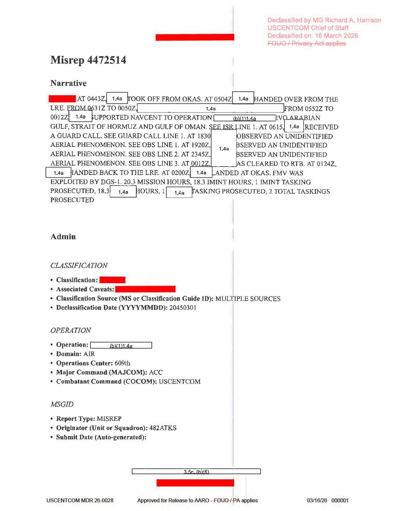
Page 1 is the mission narrative/admin page. It shows OKAS takeoff, LRE handoff, NAVCENT support across the Arabian Gulf / Strait of Hormuz / Gulf of Oman, a guardcall, three UAP observation-line references at 1830 / 1920Z / 2345Z, RTB/landing, and the statement that FMV was exploited by DGS-1.
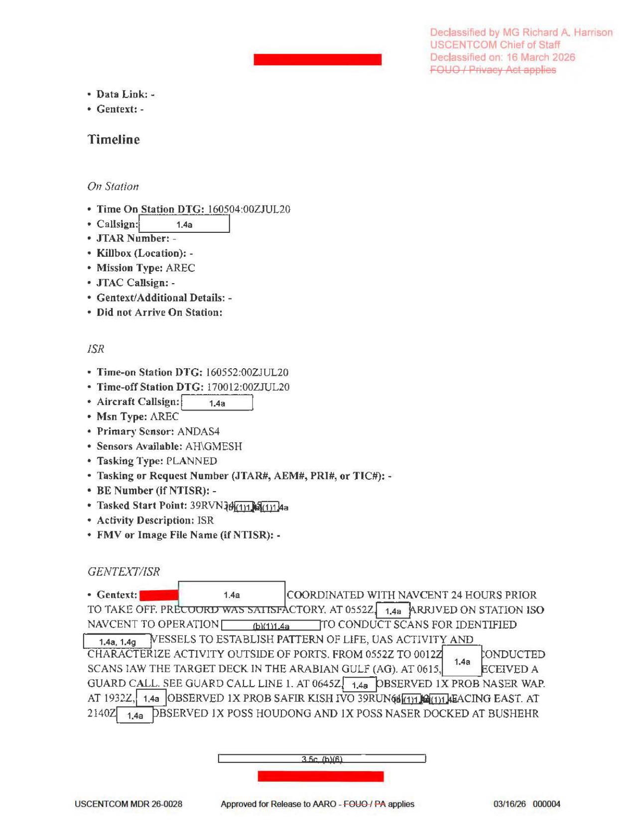
Page 4 is the ISR timeline/GENTEXT page. It preserves the NAVCENT tasking context, primary sensor ANDAS4, sensors available AH/GMSH, the blank FMV or Image File Name field, and surrounding vessel/port observations that should be kept separate from the three UAP observation blocks unless another source links them.
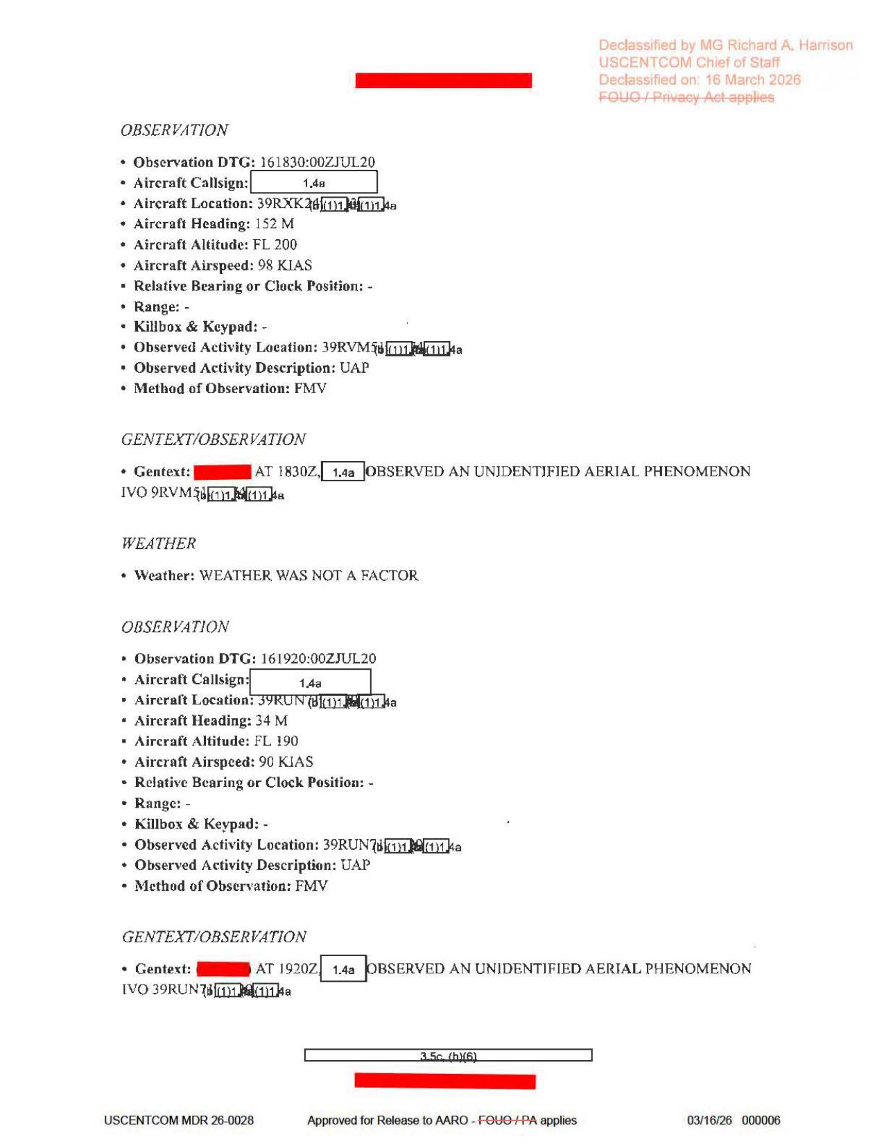
Page 6 is the first/second observation page. It shows Observation Line 1 at 161830:00ZJUL20 with heading 152M, altitude FL200, airspeed 98 KIAS, method FMV, and a partly redacted 39RVM5... observed-activity location; and Observation Line 2 at 161920:00ZJUL20 with heading 34M, altitude FL190, airspeed 90 KIAS, method FMV, and a partly redacted 39RUN7... observed-activity location.
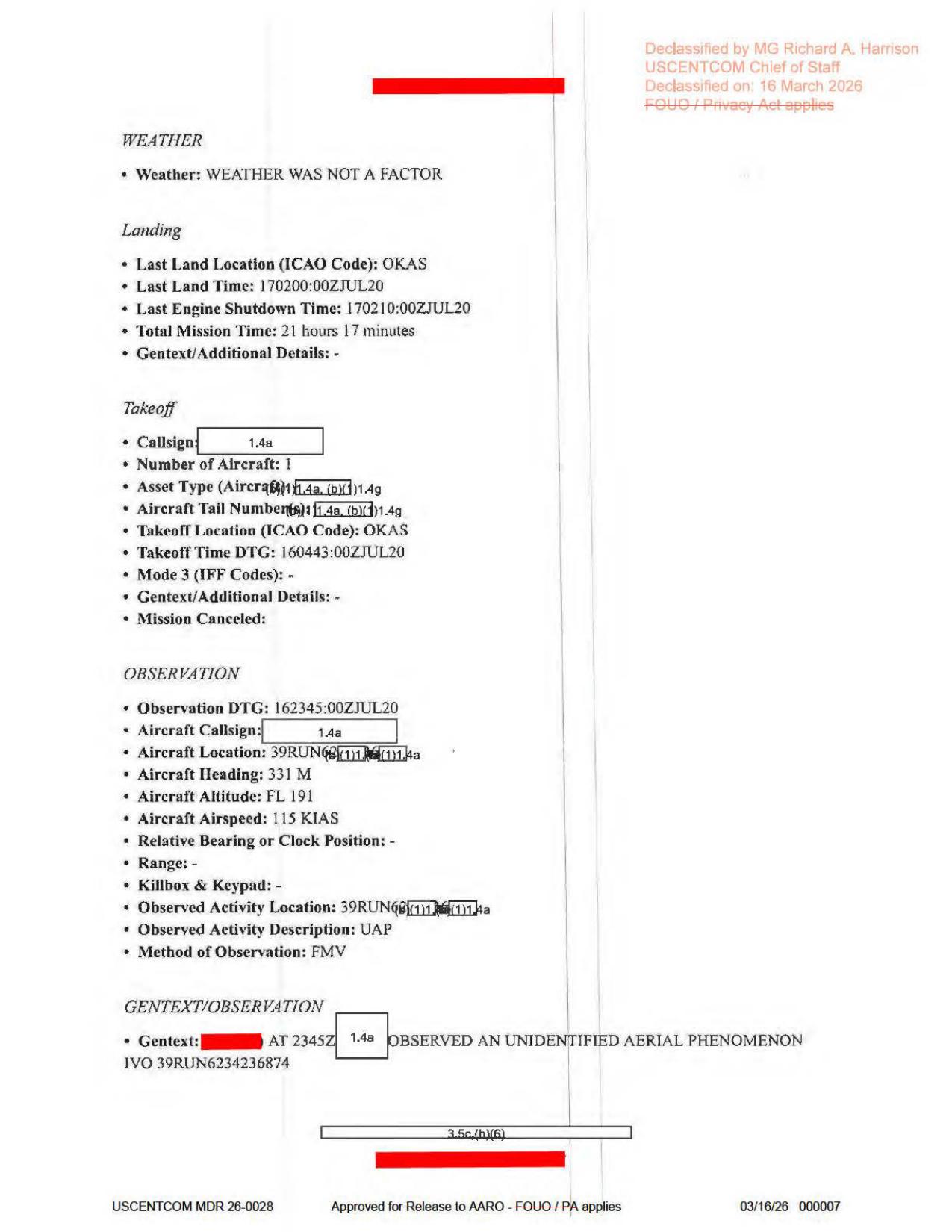
Page 7 is the landing/takeoff recap plus third observation page. It shows OKAS landing/shutdown, total mission time, takeoff time, and Observation Line 3 at 162345:00ZJUL20 with heading 331M, altitude FL191, airspeed 115 KIAS, method FMV, and GENTEXT placing the reported UAP in the vicinity of 39RUN6234236874. These are source-document page renders, not object imagery or FMV frames.
Investigation reading
This Release 01 file is an eight-page USCENTCOM MISREP-style PDF for a July 16, 2020 mission. The released CSV/record title says Arabian Gulf, while the file URL uses Persian Gulf. The report is a typed form packet with redactions; the rendered pages show no object photographs, maps, radar plots, FMV stills, cockpit displays, or other released sensor frames.
The main source reading is narrow but useful: a mission narrative and observation forms report three UAP observations on July 16, 2020. Rendered-page review corrects several OCR errors. The summary page visibly gives the three observation times as 1830, 1920Z, and 2345Z; the individual observation blocks record 161830:00ZJUL20, 161920:00ZJUL20, and 162345:00ZJUL20. The form also says FMV was exploited by DGS-1, and the second and third observation blocks list FMV as the method of observation. The page does not release the underlying FMV imagery.
A page-by-page reading:
| Page | Source reading |
|---|---|
| 1 | Main narrative, classification/operation metadata, and mission summary. The rendered page shows takeoff from OKAS at 0443Z, handover from LRE at 0504Z, NAVCENT support in the Arabian Gulf / Strait of Hormuz / Gulf of Oman, guard call at 0615, three UAP observations at 1830 / 1920Z / 2345Z, cleared RTB at 0012Z, handed back at 0124Z, landed OKAS at 0200Z, and FMV exploited by DGS-1. |
| 2 | Administrative routing, POC/QC/approver fields, units including 442 ATKS / 432 AEW / 609 AOC/CAOC, with names and contact fields redacted. |
| 3 | Aircraft/equipment form fields. Radar, RWR, MWS, IRCM, ECM, CMD, chaff, flare, towed-decoy, AAM, and gun fields are dashed or blank. The target pod field is ANDAS4 and additional avionics are rendered/OCRed as a GMESH-related entry. |
| 4 | Timeline and ISR tasking. Rendered text shows time on station 160504:00ZJUL20, ISR time-on 160552:00ZJUL20, time-off 170012:00ZJUL20, primary sensor ANDAS4, sensors available AH/GMESH, no FMV/image filename listed, and NAVCENT scanning for identified vessels. It also lists separate vessel/context observations, including a probable NASER WAP, probable SAFIR KISH, and possible HOUDONG/NASER at Bushehr. |
| 5 | ISR asset utilization, weather/effectiveness, off-station, and guardcall. The guardcall block gives 160615:00ZJUL20, aircraft altitude FL180, heading 131M, professional tone, standard call/standard response, and no mission impact. |
| 6 | Two UAP observation blocks. Rendered text shows observation 1 at 161830:00ZJUL20, aircraft heading 152M, altitude FL200, airspeed 98 KIAS, observed activity description UAP, method FMV, and a redacted/partial location beginning around 39RVM5. Observation 2 is 161920:00ZJUL20, heading 34M, altitude FL190, airspeed 90 KIAS, observed activity description UAP, method FMV, with a partial location beginning around 39RUN7. Weather says it was not a factor. |
| 7 | Landing/takeoff recap and the third UAP observation. Rendered text shows last land location OKAS, last land time 170200:00ZJUL20, engine shutdown 170210:00ZJUL20, total mission time 21 hours 17 minutes, takeoff 160443:00ZJUL20, and the third observation at 162345:00ZJUL20. The observation lists heading 331M, altitude FL191, airspeed 115 KIAS, observed activity UAP, method FMV, and GENTEXT stating the UAP was observed in the vicinity of 39RUN6234236874. |
| 8 | Sparse continuation/weather page. Rendered text says WEATHER WAS NOT A FACTOR and contains no additional visual evidence. |
What the file appears to contain
The file appears to be a text-only mission report packet, not a visual-evidence packet. Its UAP value is in the mission narrative and observation forms rather than in photographs or sensor imagery. The report preserves three reported observations during one long mission:
- 1830Z observation — Observation block on page 6 records a UAP, method FMV, aircraft altitude FL200, heading 152M, airspeed 98 KIAS, and a partly redacted activity location beginning with 39RVM5. The narrative says an unidentified aerial phenomenon was observed in the vicinity of that redacted location.
- 1920Z observation — Page 6 records a second UAP, method FMV, aircraft altitude FL190, heading 34M, airspeed 90 KIAS, and a partly redacted activity location beginning with 39RUN7. Weather is stated as not a factor.
- 2345Z observation — Page 7 records a third UAP, method FMV, aircraft altitude FL191, heading 331M, airspeed 115 KIAS, and GENTEXT giving the visible vicinity coordinate 39RUN6234236874.
The report also includes surrounding operational context: NAVCENT support, ISR scans, a guardcall with no mission impact, and vessel/port observations that appear separate from the UAP observation blocks. Those surrounding items are context, not object identifications.
Source custody and provenance
- Official/source URL: https://www.war.gov/medialink/ufo/release_1/dow-uap-d65-mission-report-persian-gulf-july-2020.pdf
- Open Sky release-file route: war-gov-dow-uap-d65-mission-report-arabian-gulf-july-2020-aef93364
- SHA-256:
bfbc281190a14c522d854c0cf2699f82de419e8f8a455949871ccdc9175bf423 - Verified size:
3,043,075bytes - PDF page count:
8 - Official CSV row:
71 - Agency: Department of War
- Release record date/location: July 16, 2020 / Arabian Gulf
The Open Sky release-file copy matches the recorded SHA-256. pdfinfo reports an eight-page encrypted/copy-disabled PDF with one scanned page image per page. The embedded PDF metadata title/subject reads DoW-UAP-D41, which does not match the released D65 title and should be treated as a provenance-cleanup lead rather than a row reassignment. The official URL filename says persian-gulf, while the public title and record title say Arabian Gulf.
Graph context
The graph has the D65 asset document and the Release 01 record document for CSV row 71. The semantic layer currently preserves 136 extracted claims, 122 entity mentions, and 9 sensor-event records for this file. These are navigation aids, not findings.
The sensor context needs special care. Source-backed terms include FMV was exploited by DGS-1, the ISR form's ANDAS4 / AH-GMESH fields, and the UAP observation blocks where pages 6 and 7 list FMV as the method of observation. By contrast, the radar/RWR/MWS/IRCM/ECM/weapon fields on page 3 are mostly dashed form prompts. They should not be read as released radar returns, raw instrument tracks, or independent sensor displays.
Related graph links to other WAR.GOV mission-report records are useful for navigation across the release, especially nearby Gulf/Strait records, but they do not establish that the same event, object, aircraft, or sensor package is involved. Candidate crosslinks from broad geography or phrase matches should remain review leads only.
Leads to check
- OCR quality: Stored OCR misreads several high-signal fields. Rendered review shows page 1 as 1830 / 1920Z / 2345Z, DGS-1, 20.3 mission hours, and 2 total taskings; OCR variants include wrong or damaged values. Page 6 OCR particularly underperforms: the rendered first observation is 161830:00ZJUL20, 152M, 98 KIAS, FMV, not the rough OCR values. The second observation renders as 34M / 90 KIAS, not the OCR rough values. Page 7 renders takeoff 160443:00ZJUL20 and observation heading 331M.
- Provenance mismatch: Reconcile D65 title/URL/CSV row 71 with embedded PDF metadata DoW-UAP-D41 and the Persian Gulf vs Arabian Gulf naming.
- Underlying media: The report says FMV was exploited by DGS-1 and lists FMV as the method for at least two observation blocks. No FMV file, image filename, still frame, or DVIDS video is included in this PDF, so a separate source-discovery pass is needed before any visual claim.
- Coordinates and redactions: The first two observed activity locations are partly redacted/obscured; the third GENTEXT visibly gives 39RUN6234236874. Coordinate interpretation should wait for a geospatial review and should respect what is actually visible in the released page.
- Surrounding vessel observations: Page 4's NASER WAP / SAFIR KISH / HOUDONG/NASER entries look like ordinary ISR/vessel context around the mission. They should be kept separate from the three UAP observation blocks unless a later source ties them together.
- Weather and prosaic checks: The UAP observation pages say weather was not a factor, but this PDF does not include raw weather products, astronomy checks, aircraft/ship track correlation, launch/satellite checks, or the FMV itself.
Lead check notes
- Checked — OCR/page-render corrections: The rendered source pages support page 1 values including
0443Z,0504Z,1830/1920Z/2345Z,DGS-1,20.3mission hours,18.3IMINT hours, and2total taskings. Page 6 supports Observation Line 1 at161830:00ZJUL20, heading152M,FL200,98 KIAS, methodFMV, and a partly redacted39RVM5...location; it supports Observation Line 2 at161920:00ZJUL20, heading34M,FL190,90 KIAS, methodFMV, and a partly redacted39RUN7...location. Page 7 supports takeoff160443:00ZJUL20, Observation Line 3 at162345:00ZJUL20, heading331M,FL191,115 KIAS, methodFMV, and GENTEXT39RUN6234236874. Stored OCR still carries damaged variants such asDOC LI,2/3mission hours,18.1IMINT hours,3total taskings,1820Z,127M,08 KIAS, and398...grid forms; use the rendered pages as the source of record for structured-data cleanup. - Partial — D65/D41 and Gulf naming: The official URL, release title, CSV row
71, source hash, and visible page content identify this file as DOW-UAP-D65. The embedded PDF metadata reportsDoW-UAP-D41, and the official filename usespersian-gulfwhile the release title/record sayArabian Gulf. That remains a source-history/metadata lead requiring official manifest history or corrected metadata before it is resolved. - Blocked — associated FMV or still media: Current Release 01 metadata exposes a row-71 PDF and no D65 DVIDS/video entry. Page 4 leaves
FMV or Image File Name (if NTISR): -; the PDF has no embedded attachments; and its embedded images are page scans rather than released sensor frames. The DGS-1/FMV trail therefore needs an external source such as the underlying FMV, stills, IIR, or AARO attachment before any visual claim. - Partial — coordinates and redactions: The first two observed-activity locations are only partly visible (
39RVM5...and39RUN7...), while page 7 visibly gives39RUN6234236874in the third GENTEXT line. OCR/searchable text may preserve this last coordinate in a damaged slash form, so map placement and redaction-sensitive coordinate cleanup should wait for page-image review and any less-redacted source. - Partial — surrounding vessel observations: Page 4's NAVCENT/NASER WAP, SAFIR KISH, HOUDONG/NASER, and Bushehr references are adjacent ISR/vessel context. The released text does not say those entries caused, identified, or resolved the three UAP observation blocks; keep them analytically separate unless another source links them.
- Needs external source — weather/prosaic checks: The observation pages say weather was not a factor, but the released PDF does not include raw weather products, track geometry, traffic/maritime data, astronomy/satellite/launch checks, or the FMV itself. Ordinary prosaic correlation work should wait for source media, unredacted coordinates, or defensible geometry.
Deep investigation — graph + web reconnaissance
Source reread
A close reread of the verified PDF and derived page renders supports treating D65 as a text/report packet, not a released visual-evidence packet. Page 1 is stronger than the OCR: it reads as a July 16, 2020 mission narrative with takeoff from OKAS at 0443Z, LRE handoff at 0504Z, NAVCENT support across the Arabian Gulf / Strait of Hormuz / Gulf of Oman, guard call at 0615, three UAP observation references at 1830, 1920Z, and 2345Z, RTB/landing sequence at 0012Z / 0124Z / 0200Z, and FMV WAS EXPLOITED BY DGS-1. It also supports 20.3 mission hours, 18.3 IMINT hours, one IMINT tasking, and two total taskings. OCR variants such as DOC LI, 2/3 mission hours, and 3 total taskings should be treated as transcription errors.
Pages 6 and 7 are the key source pages. Render review supports Observation Line 1 at 161830:00ZJUL20, aircraft heading 152M, altitude FL200, airspeed 98 KIAS, observed-activity location prefix 39RVM5..., observed-activity description UAP, method FMV, and GENTEXT time 1830Z. Observation Line 2 reads 161920:00ZJUL20, heading 34M, altitude FL190, airspeed 90 KIAS, location prefix 39RUN7..., UAP, method FMV, and GENTEXT time 1920Z. Observation Line 3 reads 162345:00ZJUL20, heading 331M, altitude FL191, airspeed 115 KIAS, UAP, method FMV, and GENTEXT IVO 39RUN6234236874 at 2345Z. These headings, altitudes, and airspeeds are aircraft/platform fields unless another source says otherwise; they are not object-performance measurements.
Graph connections
Read-only graph checks found the exact D65 PDF asset and the current Release 01 row-71 record. The stable identifiers are the official PDF URL, title, 3,043,075-byte size, and SHA-256 bfbc281190a14c522d854c0cf2699f82de419e8f8a455949871ccdc9175bf423. The graph semantic layer currently carries 136 machine-extracted Claim nodes, 122 EntityMention nodes, and 9 SensorEvent nodes for this source. Those records remain machine_extracted_needs_human_review / not_a_finding and are useful only as pointers back to the source pages.
The sensor-event extraction needs cleanup language. FMV is source-supported as a report method and exploitation cue, but the PDF does not release the FMV, a still, a filename, or a DVIDS packet. The graph also has an IR-type sensor cue produced from the aircraft-equipment checklist / IR-guided AAM wording, which is a form-field extraction artifact, not a positive IR observation. Direct graph relationships show a provenance drift worth fixing later: the row-71 D65 record can carry a stale D62 final-file URL/byte value, while a non-current relation to D75 can carry the D65 final URL/byte value. That is a manifest/row-alignment issue, not corroboration and not a second D65 source.
External provenance and official-source probes
The official WAR.GOV/PURSUE PDF URL, UFO landing page, and guessed release CSV route all returned access-denied responses during this check. That does not invalidate the Open Sky release-file copy because the verified bytes match the source hash and size, but it does mean live official re-fetch and CSV row confirmation remain blocked from this network path. AARO and Defense.gov exact-title searches likewise returned access-denied responses; DVIDS exact-title search returned no usable companion record. Internet Archive availability/CDX probes for the exact official PDF were unavailable during the check (429 / 503). A general exact-title web search surfaced secondary mirrors such as a PursueFiles case page and corpus viewers, but those are discovery leads only and are not used as independent source facts here.
Prosaic checks and follow-up leads
The first prosaic lane is not “what object was it?” but “what context is missing?” The PDF says weather was not a factor, but it does not provide raw weather products, platform track, look angle, elevation, range, object bearing, target-pod settings, FMV frames, vessel tracks, aircraft/traffic data, satellite passes, or unredacted MGRS coordinates. Graph checks found no modeled LaunchEvent on 2020-07-16; in the 2020-07-13 to 2020-07-20 graph window the only modeled launch was ANASIS-II on 2020-07-20. The graph also returned no exact-date Gulf/Hormuz weather records and no exact-date astronomy records. Those are graph-coverage notes, not external exclusions.
The strongest next checks are: obtain any underlying FMV/still/IIR attachment tied to the DGS-1 exploitation note; reconcile the D65/D41 embedded metadata and Persian-vs-Arabian Gulf naming; repair row-71/D62/D75 graph field drift; map only the visible MGRS fragments with redaction-aware handling; and compare the surrounding NAVCENT/vessel context against maritime traffic and port activity without assuming it explains any of the three UAP observation blocks.
Audit note
This section distinguishes the report's source facts from machine graph claims and from unresolved correlation work. The file supports three reported UAP observations in one mission report, with FMV named as a method/exploitation context, but it does not release imagery or enough geometry to identify, resolve, or escalate the events.
Limits
This is an investigation draft, not a finding. The file does not identify the objects, resolve the events, or provide released imagery. Heavy redactions remove aircraft identity, callsigns, most locations, and operational details. The PDF is a scanned form packet; several high-signal values require rendered-page review because OCR is noisy. The graph's extracted claims and sensor events should be used as pointers back to the source pages, not as independent corroboration.
Sources
- Department of War / WAR.GOV PURSUE Release 01, DOW-UAP-D65, Mission Report, Arabian Gulf, July 2020, official PDF URL above.
- Open Sky release-file route for this asset, SHA-256
bfbc281190a14c522d854c0cf2699f82de419e8f8a455949871ccdc9175bf423. - Rendered-page review of pages 1-8 from the verified PDF, with close checks on pages 1, 4, 5, 6, and 7.
- Open Sky semantic graph context for the D65 asset and CSV row 71 record; all graph-derived items remain
graph_investigation_draft,needs_human_review, andnot_a_finding.