DOW-UAP-PR31, Unresolved UAP Report, Syria, October 2024
Evidence media
- Open Sky release-file copy of the official PR31 MP4 — verified as a 644,525-byte, 5.13-second MP4 with SHA-256
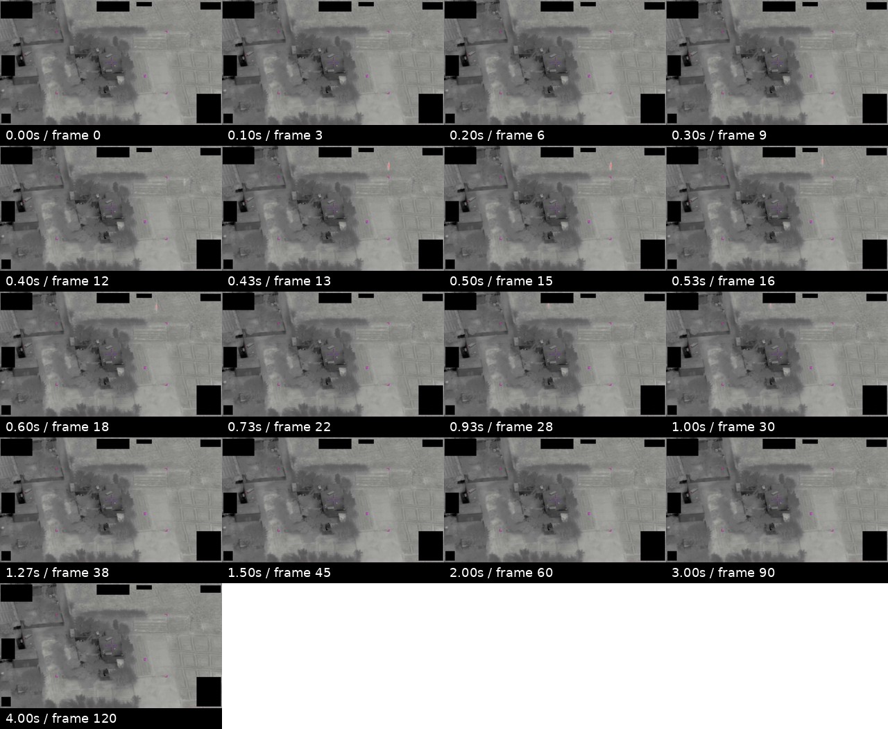
8f8b4857ef6e4f46f54a90f15877c793c6cdb0d94b0c4f5de28868be0004dfd0. - Derived full-frame contact sheet from the official PR31 MP4 — included for scene and overlay context.
Derived frame context from the official PR31 MP4 is included below. The image is a top-band crop contact sheet from sampled frames, not standalone object imagery.
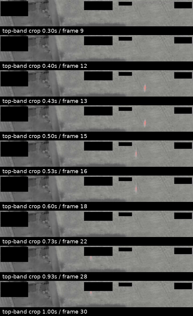 The crop sheet samples the upper display band where the official description locates the short multi-colored feature. It shows a tiny reddish/orange mark in several first-second samples, with black masks and magenta interface marks remaining separate display elements.
Investigation reading
This page covers the PR31 DVIDS video item, not the full mission report. The reviewed source is a 644,525-byte MP4, 5.13 seconds long, 1920 x 1080, H.264 at 30 fps, with SHA-256 8f8b4857ef6e4f46f54a90f15877c793c6cdb0d94b0c4f5de28868be0004dfd0. The audio stream is present but effectively silent in the reviewed file. No transcript or OCR body text is attached to this video item.
The video shows a grayscale full-motion-video style overhead scene of a small compound, tracks or roads, trees, and field-like textures. The view is partly covered by black rectangular masking/redaction blocks and by magenta interface graphics, including bracket-like marks and an N orientation marker. Those interface elements are separate from the underlying sensor scene.
The official DVIDS description says that from 00:00-00:01 an indistinct multi-colored area moves from right to left across the top edge of the sensor display. Frame review supports a cautious version of that description: a tiny reddish/orange colored mark is visible in the upper band during the first second, appearing around the right side near 0.43-0.50 seconds, farther left around 0.53-0.60 seconds, and farther left again near 0.93-1.00 seconds. It is very small, close to masked top-edge display areas, and not resolved into a diagnostic shape.
What the file appears to contain
The original scene content is the grayscale overhead imagery: buildings or roof shapes near the center-left, vegetation-like dark patches, a roadway or track running near the compound, and patterned open ground to the right and lower portions of the frame. The central scene does not show a large, clearly resolved aircraft, vehicle, plume, person, or object at this scale.
The small upper-edge colored feature is the item to preserve for follow-up. In the reviewed frames it appears as a narrow red/orange mark or streak against the grayscale imagery. Its apparent image position changes leftward during the first second. The clip does not provide enough visible detail to determine whether that mark is a distant object, optical effect, display/rendering artifact, compression artifact, sensor-edge effect, or another cause. The public reading should therefore keep it as an unresolved moving visual feature, not as an identification.
The black blocks are masking/redaction or display-obscuration elements. The magenta marks are interface overlays. They should not be described as scene objects. Because the colored feature passes near the upper display band, the masking and overlay context matters for later analysis.
Source custody and provenance
The release identifies this as a Department of War / PURSUE Release 01 video record hosted by DVIDS:
The Open Sky release-file copy is available here:
Release metadata associates the video with CSV rows 48 and 88, incident location Syria, and DVIDS video ID 1006076. The paired mission-report source is DOW-UAP-D32, Mission Report, Syria, October 2024, which records the broader October 20, 2024 UAP/glare narrative and ties PR31, PR32, and PR33 to the same Syria report cluster.
Graph context
The graph models this item as an official primary VideoEvidence node and also preserves related release-record Document nodes for the DVIDS/video row and the paired D32 mission-report row. The current semantic layer surfaces 28 extracted claims, 21 entity mentions, and 3 sensor-event records for this video item. Those are navigation aids for review, not findings.
The strongest graph/source signals are the DVIDS/Department of War custody, the D32 pairing, the Syria location, the FMV wording, and the official description of a short top-edge visual feature during the first second. The three sensor-event records are based on FMV references in the manifest text; they are not independent radar tracks, telemetry records, or additional sensor returns.
Related graph records include the D32 PDF and the other short Syria October 2024 videos PR32 and PR33. Location-only or phrase-only candidate crosslinks to older archives or meteor/fireball resources should be treated as search leads, not same-event evidence.
Leads to check
- Compare PR31 against PR32 and PR33 frame by frame and map each clip to D32's source timeline for
1559Z,1602Z,1609Z,1620Z, and1644Zglare/halo statements. - Check whether the upper-edge colored mark aligns with display overlays, masked regions, top-edge cropping, sensor saturation, compression, or other video-pipeline artifacts.
- Review the paired D32 PDF page text when quoting the descriptive phrase
MISHAPEN AND UNEVEN BALL OF WHITE LIGHT; the video description uses normalizedmisshapenwording. - Reconcile the release row numbering before citation cleanup: this video page carries rows
48and88, while the paired D32 PDF page carries row47plus paired video rows. - External astronomy, weather, satellite, launch/reentry, aircraft, and drone checks require unredacted geometry or defensible approximations; the PR31 clip alone does not supply them.
Lead check notes
- Partial — PR31/PR32/PR33 alignment: The paired D32 page and PR31/PR32/PR33 source pages confirm that the three short videos are grouped with the same Syria October 2024 mission-report cluster. PR31 frame samples show the first-second upper-band feature; PR32 has a separate human-readable video page; PR33 still needs dedicated frame-level review before the three clips can be mapped to D32's
1559Z,1602Z,1609Z,1620Z, and1644Zsource statements. - Partial — top-edge feature/artifact checks: The PR31 MP4 and derived top-band contact sheet show a tiny reddish/orange mark in several sampled first-second frames, with apparent leftward image-position change. The mark is close to top-edge masks/cropping and display overlays, so artifact checks remain open without an unredacted or higher-fidelity display export.
- Checked — D32 descriptive quote: The paired D32 page preserves the source spelling
MISHAPEN AND UNEVEN BALL OF WHITE LIGHT; the DVIDS/video description uses normalizedmisshapenwording. Public quotations should keep the distinction. - Partial — release row cleanup: PR31 carries rows
48and88; the paired D32 PDF carries row47plus related rows85,86, and87; PR32 carries49/89; PR33 carries50/90. Treat this as a release-provenance citation cleanup issue, not as same-event resolution. - Needs external source — environment and traffic checks: Astronomy, weather, satellite, launch/reentry, aircraft, drone, and line-of-sight checks need unredacted geometry or defensible approximations that the public PR31 clip does not provide.
Deep investigation — graph + web reconnaissance
Source reread
A second pass checked the PR31 video as its own source item and then compared it with the paired D32 mission-report page. The cached official MP4 verifies as 644,525 bytes with SHA-256 8f8b4857ef6e4f46f54a90f15877c793c6cdb0d94b0c4f5de28868be0004dfd0; a direct DVIDS/CloudFront range request also returned 206 with Content-Range: bytes 0-15/644525 and MP4 ftyp bytes. The live DVIDS page identifies the item as video ID 1006076, filename DOD_111688970, category B-Roll, length 00:00:05, location SY, and describes a five-second FMV clip submitted by USCENTCOM to AARO.
Frame/contact-sheet review supports only a cautious visual reading. The full-frame sheet shows a grayscale overhead scene with a small compound, roads or tracks, field-like ground texture, fixed black masking/redaction blocks, and sparse magenta interface marks. The top-band sheet shows a tiny pink/magenta-to-orange dash or smear in several first-second crops, with apparent leftward image-position change. It is not resolved into a body, wing, rotor, plume, or diagnostic shape, and it remains close to the masked/overlay-heavy upper display band.
The paired D32 mission report remains the source-text anchor for timing and wording: pages 7-9 place the event at 201559:00ZOCT24, describe light/glare crossing an FMV camera feed, preserve the source spelling MISHAPEN AND UNEVEN BALL OF WHITE LIGHT, and list glare/halo statements at 1559Z, 1602Z, 1609Z, 1620Z, and 1644Z. PR31 can preserve one visual segment from that cluster, but the clip alone does not map itself to all D32 timeline entries.
Graph connections checked
Read-only graph reconnaissance matched PR31 as an official primary VideoEvidence node with DVIDS ID 1006076, the same canonical DVIDS URL, Syria location, paired 10/20/24 / N/A incident-date metadata, and two manifest-description text chunks. The current semantic layer has 28 machine-extracted claims, 21 entity mentions, and 3 machine-extracted SensorEvent records for this video. Those sensor records are all FMV/manuscript-cue extractions marked machine_extracted_needs_human_review / not_a_finding; they are not independent radar, telemetry, or multi-sensor confirmations.
The narrow source-backed cluster is PR31 plus D32 and the other two Syria October 2024 short DVIDS videos, PR32 and PR33. Graph release-record relationships around this cluster still show row/title/URL drift in places, so exact DVIDS ID, canonical video URL, MP4 size/hash, and the D32 PDF source text are the stable identifiers for public citation. No direct candidate crosslink provided same-event corroboration in this pass.
Official web reconnaissance
The DVIDS page was reachable and preserves the official video-custody record. Its description says the clip is five seconds of full-motion-video footage from a U.S. military platform in 2024 and includes an explicit caution that the video description is informational, not an analytical judgment or factual determination about the event's nature. DVIDS lists Date Taken: 10.01.2024 and VIRIN 241002-D-D0360-8752, while the paired D32 PDF's internal fields point to 20 OCT 2024; that date tension should be reconciled before treating the DVIDS date as the event time.
WAR.GOV/PURSUE landing and CSV probes returned access-denied responses from this environment, so the verified release-file copy and the live DVIDS page remain the strongest accessible custody sources for this check. Internet Archive availability for the DVIDS page returned rate limiting during this pass, not a usable snapshot.
Prosaic checks and open limits
The first prosaic lane is video/display/sensor handling: top-edge frame effects, black mask boundaries, magenta symbology, false-color or thermal processing, compression/resampling, lens/sensor glare, platform/sensor motion, and the source's own light/glare halo effect wording. Graph exact-date probes returned no modeled AstronomyEvent, WeatherEvent, or narrow-window LaunchEvent rows for the public 20 October 2024 date, but that is only a graph-coverage note. PR31 lacks unredacted coordinates, look angle, platform track, sensor settings, and raw FMV metadata, so astronomy, weather, aircraft, drone, satellite, launch/reentry, and line-of-sight checks remain blocked rather than cleared.
Audit note
This deep pass made no Neo4j writes and creates no finding or hypothesis. It strengthens the source hierarchy for PR31: DVIDS/MP4 custody and frame review first, paired D32 source text second, graph extraction as unreviewed navigation, and external prosaic checks only where geometry and source data allow.
Limits
This is an investigation draft, not a finding. The clip is only 5.13 seconds long. It contains a tiny unresolved visual feature near the top edge, not enough visible structure to classify the feature. The scene is partly obscured by black masks and overlaid by magenta display graphics. The video lacks transcript text, exact unredacted coordinates, platform identity, range, altitude-to-target geometry, and raw sensor telemetry.
The paired D32 mission report supplies important context, but PR31 by itself should not be used to resolve the event. It preserves one short visual segment that needs comparison with the other paired clips and with any unreleased or higher-fidelity source media.
Sources
- Department of War / DVIDS video page: DOW-UAP-PR31, Unresolved UAP Report, Syria, October 2024
- Open Sky release-file copy: war-gov-dow-uap-pr31-unresolved-uap-report-syria-october-2024-1006076
- SHA-256:
8f8b4857ef6e4f46f54a90f15877c793c6cdb0d94b0c4f5de28868be0004dfd0 - Paired mission report: DOW-UAP-D32, Mission Report, Syria, October 2024