DOW-UAP-PR39, Unresolved UAP Report, Middle East, 2020
Evidence media
- Open Sky release-file MP4 — the official Release 01/DVIDS video copy reviewed for this page.
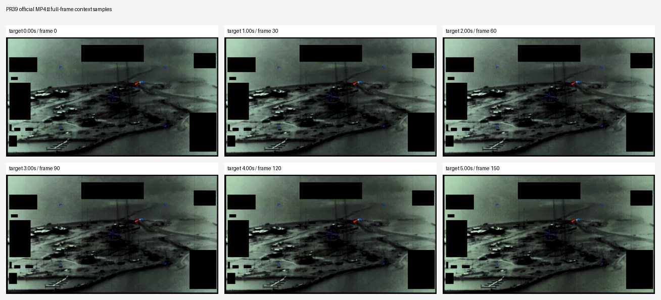
Derived frame-contact sheet from the official MP4, sampling the full frame across the short clip. It shows the masked infrared-style scene context, including black redaction blocks and small colored overlay marks that should be separated from physical scene content.
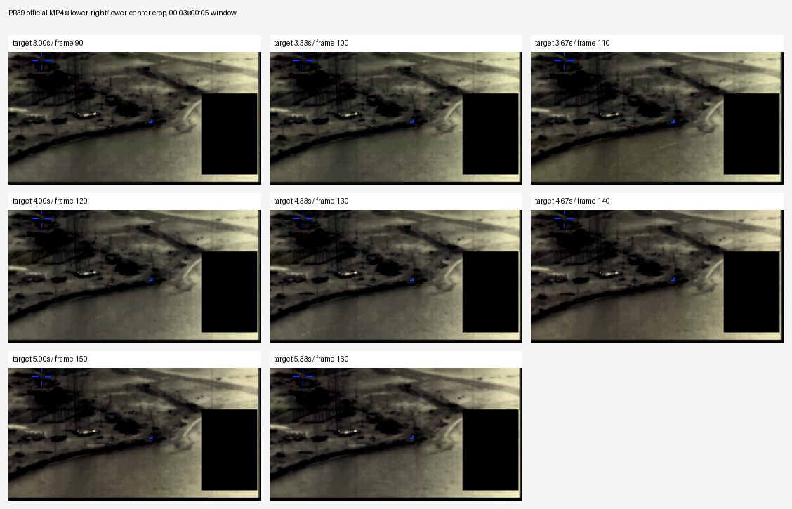
Derived crop contact sheet from the official 00:03–00:05 window, focused on the lower-right and lower-center area described by DVIDS. The sampled frames show a faint, low-contrast patch or tonal disturbance near the lower-right/lower-center shoreline-like region, but it remains too diffuse and compressed to identify or quantify from the public MP4 alone.
Investigation reading
This draft treats PR39 as a short official video source, not as an adjudicated case. I reviewed the verified Release 01 MP4, the DVIDS public page metadata, the official manifest description, and the Open Sky graph context for the matching video record.
The reviewed file is a 1,708,179-byte MP4 with SHA-256 b0975d88681b2d0afb31cf83c43d4e63fedef67fec5687795bdec257decb0825. The media stream is H.264 video at 1920×1080, 30 fps, with a duration of about 5.83 seconds. The container also carries an AAC audio stream, but the release description says the reporter did not provide any oral or written description of the observation, and there is no transcript or narrative report in this video record.
For the visual pass, I checked full-frame samples across the whole clip and closer lower-right/lower-center crops from roughly 00:03 through 00:05, the interval called out in the official description. The source frames are grayscale infrared-style imagery with black masked/redacted regions and small colored symbology or marks. Those masks and annotations are release/video presentation elements and should not be treated as physical scene content.
What the file appears to contain
The official DVIDS/Release 01 description says United States Central Command submitted a report to AARO consisting of five seconds of infrared-sensor footage from a U.S. military platform in 2020. It states that, from 00:03 to 00:05, a faint area of contrast enters the sensor field of view from the lower half of the right edge, moves right-to-left across the corner of the frame, and exits near the center of the bottom edge. The same description warns readers not to treat that description as an analytical judgment, investigative conclusion, or factual determination.
The reviewed video is consistent with that limited description. The scene appears to be an oblique infrared view over terrain/water or shoreline-like background, but the video itself does not establish an exact location. In the lower-right portion of the usable image area, a very faint, diffuse contrast patch becomes easier to notice between about 00:03 and 00:05. It appears to move generally from the right side toward the lower-center/lower-left direction. In individual frames it is small, low contrast, and hard to separate cleanly from background texture, compression, sensor noise, and frame-to-frame jitter.
Nothing in the released clip resolves the feature into a definite object type. I do not see source-native detail that would support a shape, size, range, altitude, propulsion, or identity determination from this release file alone. The safest visual description is therefore: a tiny unresolved contrast feature or patch is visible in the lower-right/lower-center portion of the infrared imagery during the officially described interval.
Source custody and provenance
The public DVIDS page is titled DOW-UAP-PR39, Unresolved UAP Report, Middle East, 2020, video ID 1006089, filename DOD_111689057, VIRIN 200102-D-D0360-2155, category B-Roll, length 00:00:05, location (UNDISCLOSED LOCATION), date taken 01.01.2020, and date posted 05.08.2026 07:47. The Release 01 metadata identifies the incident location as Arabian Gulf and the incident date as N/A.
The Open Sky release-file copy matches the byte count and SHA-256 hash above. The Release 01 metadata associates this video asset with CSV row 96. The exact graph release-record node currently points to a WAR.GOV current-row anchor numbered 93, so row numbering should be treated as an audit/provenance field to reconcile against the current WAR.GOV CSV rather than as a stable case fact.
Graph context
Open Sky has an exact VideoEvidence record for DVIDS 1006089 and a release-record Document node for the WAR.GOV/PURSUE Release 01 listing. The semantic extraction currently reports 10 claims, 8 entity mentions, 0 sensor events, and 0 table rows for this asset.
The graph context is useful but narrow. Several extracted claims are just metadata or boilerplate: AARO, Department of War, dvids, DOW-UAP-PR39, Middle East, Arabian Gulf, 2020, and 2026. The extraction also treats the official cautionary disclaimer as an observation or witness-testimony statement; for human reading, that should be understood as release-context language, not an independent witness account.
Related graph links include DOW-UAP-D38, Range Fouler Debrief, Middle East, May 2020, DOW-UAP-PR36, Unresolved UAP Report, Middle East, May 2020, and DOW-UAP-PR42, Unresolved UAP Report, Middle East, 2020. Candidate crosslinks are driven mostly by broad anchors such as Middle East and Unresolved UAP Report; they are navigation leads only, not evidence that these records describe the same event.
Leads to check
- Reconcile the Release 01 row-number tension: metadata row
96versus the graph release-record anchor around current row93. - Compare PR39 against PR36, PR42, and D38 only at the source level before treating them as a cluster; shared region/year language is not enough to merge events.
- If the original sensor file or uncompressed source becomes available, rerun the 00:03-00:05 frame analysis against that source rather than the compressed public MP4.
- Check whether the DVIDS
Date Taken: 01.01.2020is a placeholder date, a metadata default, or the best available event-date field. - Quantify the faint patch against background motion, compression blocks, and sensor jitter before making any analytic statement about trajectory or speed.
Lead check notes
- Checked — The release-file MP4 link, DVIDS ID
1006089, byte count1,708,179, SHA-256b0975d88681b2d0afb31cf83c43d4e63fedef67fec5687795bdec257decb0825, and official 00:03–00:05 description are aligned with the reviewed PR39 source metadata. - Partial — The row-number issue remains provenance cleanup: the video source metadata points to row
96, while the WAR.GOV current-row anchor surfaced in graph context points around row93. That mismatch should not be used as an event fact until checked against official manifest history. - Partial — PR36, PR42, and D38 remain source-level comparison leads only. Current graph/source context ties them to PR39 through broad Middle East/2020/Release 01 labels; it does not prove that the records describe the same observation.
- Blocked — The compressed public MP4 is not enough to quantify the faint patch against background motion, compression behavior, sensor jitter, or platform motion. That check needs the original sensor file or uncompressed export, platform/sensor metadata, and track geometry.
- Needs external source — The
Date Taken: 01.01.2020field and ordinary prosaic checks such as traffic, weather, satellite/reentry activity, drones, birds/debris, or local illumination need external timing/location data beyond the broad Middle East/Arabian Gulf metadata in this release file.
Limits
This is a five-to-six-second public video clip with no accompanying narrative report, no platform details beyond the official U.S. military platform language, no disclosed sensor model, no range, no altitude, no target track, no weather context, no original telemetry, and no resolved object imagery. The video supports only a cautious source-reading note about a faint unresolved contrast feature during 00:03-00:05. It does not support a finding, hypothesis, identification, or resolution decision.
Sources
- DVIDS official page: https://www.dvidshub.net/video/1006089/dow-uap-pr39-unresolved-uap-report-middle-east-2020
- DVIDS short URL: https://www.dvidshub.net/video/1006089
- Open Sky release-file copy:
/api/explore/war-gov/release-file/war-gov-dow-uap-pr39-unresolved-uap-report-middle-east-2020-1006089 - SHA-256:
b0975d88681b2d0afb31cf83c43d4e63fedef67fec5687795bdec257decb0825 - Open Sky Release 01 graph/source context for
official:video:war-pursue-uap-release:dvids-1006089
Deep investigation — graph + web reconnaissance
Source reread and media check
PR39 remains a short official DVIDS video record, not a complete incident packet. The verified Release 01 MP4 is 1,708,179 bytes with SHA-256 b0975d88681b2d0afb31cf83c43d4e63fedef67fec5687795bdec257decb0825; the container begins with MP4 ftyp bytes and decodes as a 1920×1080 H.264 stream at 30 fps for about 5.83 seconds, with an AAC audio stream. The DVIDS page lists video ID 1006089, filename DOD_111689057, VIRIN 200102-D-D0360-2155, category B-Roll, location (UNDISCLOSED LOCATION), date taken 01.01.2020, date posted 05.08.2026 07:47, and courtesy credit to the All-domain Anomaly Resolution Office.
The official description is narrow: it says CENTCOM submitted five seconds of infrared-sensor footage from a U.S. military platform in 2020, with no oral or written observer description, and that a faint area of contrast is described from 00:03–00:05. It also explicitly warns that the description is informational only and should not be read as an analytical judgment or factual determination. A fresh review of the derived full-frame and lower-right/lower-center contact sheets supports the caution already on this page: the public clip shows masked infrared-style imagery with black redaction blocks, blue/red overlay marks, compression, sensor noise, and low contrast. In the 00:03–00:05 crop, any lower-right/lower-center patch is extremely subtle and not cleanly separable as a trackable object from still frames alone.
Graph connections and extraction quality
Neo4j has an exact VideoEvidence node for official:video:war-pursue-uap-release:dvids-1006089, linked to the official DVIDS URL, the CloudFront MP4 URL, related CSV row 96, the exact MP4 byte count, and the exact full-download hash. The semantic layer currently has 10 machine-extracted Claim nodes and 8 EntityMention nodes for the video asset, with 0 SensorEvent nodes. The entity/claim set is mostly metadata: DOW-UAP-PR39, AARO, Department of War, DVIDS, Arabian Gulf, Middle East, 2020, and 2026.
The graph also surfaces useful cleanup cautions. A Release 01 row-record Document for the same DVIDS ID is anchored to WAR.GOV current row 93, while the video asset and page inventory use row 96; that row-number drift should remain a provenance reconciliation lead rather than an event fact. The same row-record still carries a stale final_url value for the D38 Range Fouler Debrief, and the video node has a manifest-style RELATED_TO edge to PR42. Those are navigation/provenance artifacts until source-level evidence proves a real pairing. Candidate crosslinks from the row-record are broad audit-only matches based on anchors like Middle East or Unresolved UAP Report; they do not establish identity, causality, corroboration, or resolution.
External provenance and web checks
The canonical DVIDS page and the short DVIDS URL both returned the PR39 page directly, with the same title and metadata above. A range request against the DVIDS/CloudFront MP4 returned 206 Partial Content with Content-Range: bytes 0-2047/1708179, matching the release-file byte total. Direct WAR.GOV landing-page and CSV probes returned 403 Forbidden during this check; that is an access/custody limitation, not a contradiction of the verified DVIDS and Open Sky release-file copy. Internet Archive CDX checks for the DVIDS page and MP4 timed out or returned service errors in this pass, so archive captures remain a follow-up lead rather than replacement custody evidence.
Prosaic checks and unresolved limits
The released source does not provide an exact event date, exact location, platform track, sensor model, range, altitude, line of sight, target distance, weather, traffic picture, or raw telemetry. The DVIDS Date Taken: 01.01.2020 field is useful metadata, but by itself it is not enough to run a meaningful weather, astronomy, launch, satellite, aircraft, maritime, bird/debris, or illumination correlation for an (UNDISCLOSED LOCATION) / Arabian Gulf video. Graph datasets for weather, astronomy, and launches exist, but without a real timestamp and geometry, no case-specific exclusion or match should be claimed from them.
Follow-up leads
- Reconcile Release 01 row
96with the graph row-record anchor at93, and clean stale D38/PR42 relationship fields if the manifest history confirms they are drift artifacts. - Preserve PR39 as a source-level video page unless the underlying sensor file, platform data, or unredacted report becomes available.
- If the original sensor export is released, repeat the 00:03–00:05 review with frame stabilization, compression/noise controls, and the unmasked sensor geometry before making any motion or object statement.
- Recheck WAR.GOV CSV/landing and Internet Archive exact-URL captures later for custody redundancy, but do not treat broad DVIDS or AARO search hits as corroboration without exact PR39 source identity.
Audit note
This section adds graph-plus-web context only. It does not create a finding, hypothesis, identification, or resolution decision. Machine-extracted graph claims remain machine_extracted_needs_human_review unless directly verified against the official page, manifest text, or MP4 media.