DOW-UAP-PR40, Unresolved UAP Report, Middle East, 2020
Evidence media
- Open Sky release-file MP4: DOW-UAP-PR40, Unresolved UAP Report, Middle East, 2020
- Official DVIDS video page
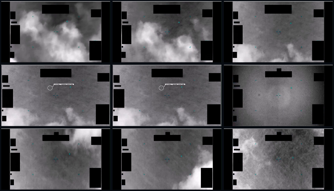
Derived full-frame review sheet sampled from the verified MP4, including the opening sequence, the paused annotation interval, and later tracking/contrast-cycling moments.
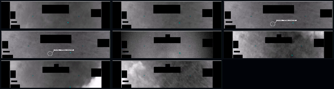
Derived top-band review sheet focused on the source-added U/I SMALL THERMAL SIGNATURE annotation interval. The white callout/label is part of the submitted/released video presentation, not an Open Sky identification.
The verified release-file copy is a 29,392,078-byte MP4 with SHA-256 e91f12de19cadaa3af6c324bc3caa83af2ce47c80fefbceeb5e038f5c1866dac. It is a grayscale infrared/sensor video; during the paused 00:10–00:14 interval, a white callout added before AARO publication labels a tiny highlighted area U/I SMALL THERMAL SIGNATURE. The video and annotation are source media, not an identification or resolution of the highlighted feature.
Investigation reading
This draft treats PR40 as a short official DVIDS video record, not as an adjudicated case. The released item is a 63.20-second, 1920×1080 H.264 MP4 titled “DOW-UAP-PR40, Unresolved UAP Report, Middle East, 2020.” The DVIDS page identifies the asset as Video ID 1006093, VIRIN 200102-D-D0360-7746, filename DOD_111689082, category B-Roll, courtesy video from the All Domain Anomaly Resolution Office, date taken 01.01.2020, date posted 05.08.2026 07:49, and location (UNDISCLOSED LOCATION).
The Release 01 metadata records the incident location as Arabian Gulf, while the DVIDS title uses Middle East and the DVIDS page itself displays (UNDISCLOSED LOCATION). Those should be read as provenance fields to reconcile, not as a resolved geographic finding. The verified MP4 is 29,392,078 bytes with SHA-256 e91f12de19cadaa3af6c324bc3caa83af2ce47c80fefbceeb5e038f5c1866dac.
This draft checked the DVIDS metadata, the official description, the verified MP4, representative full-frame contact sheets across the whole clip, a dense upper-frame contact sheet sampled every two seconds, and a high-resolution crop of the 00:10–00:14 annotation interval. The file includes an AAC stereo audio stream, but audio-level review found effectively silent audio at the detectable level; the useful evidence in this release is visual plus the publisher’s text description.
What the file appears to contain
The released video is grayscale sensor imagery with display symbology, black masked/redacted areas, and changing contrast/zoom presentation. The visible scene is mostly low-contrast cloud or haze texture, with sensor/display marks layered over it. The black rectangular blocks, cyan/teal symbology, reticle-like marks, and the later white callout annotation are display or release-video elements and should not be read as physical objects in the scene.
The publisher description divides the clip into three segments:
| Time range | Source-backed reading |
|---|---|
00:00–00:09 | A contrast area brightens within the sensor field of view and becomes more distinct against the background. In the sampled frames, the scene is mottled grayscale/cloud texture with sensor symbology and masking. |
00:10–00:14 | Playback pauses and a white annotation circles/points to an area labeled U/I SMALL THERMAL SIGNATURE. The high-resolution crop makes the label legible and shows a tiny bright speck or small cluster inside the callout. This is an unresolved point-like feature; the white circle, arrow, and label are annotations, not original scene content. |
00:15–01:03 | Playback resumes while the sensor pans and cycles contrast/zoom settings. Dense two-second sampling supports broad visual continuity in the upper part of the frame, but the same tiny feature is not cleanly isolatable in every still frame from the contact sheet alone. |
The most direct visual statement supported by this release is narrow: a tiny unresolved thermal/contrast feature is highlighted by an added annotation in the paused interval, and the later video appears to continue tracking a contrast area in the upper portion of the frame while display processing changes. The released MP4 does not, by itself, identify the feature’s nature, altitude, distance, size, platform, or motion independent of the sensor view.
Source custody and provenance
The public source is DVIDS: DOW-UAP-PR40, Unresolved UAP Report, Middle East, 2020. The page’s MP4 source is https://d34w7g4gy10iej.cloudfront.net/video/2605/DOD_111689082/DOD_111689082.mp4, and the Open Sky release-file endpoint is war-gov-dow-uap-pr40-unresolved-uap-report-middle-east-2020-1006093.
DVIDS attributes the page to the All Domain Anomaly Resolution Office and marks the item public domain. The official description says United States Central Command submitted one minute and three seconds of infrared-sensor footage to AARO. It also says the original reporter, not AARO, digitally altered the imagery by pausing playback and adding the white line/callout at timestamp 00:10; AARO is said to have presented the media as received.
Two custody details need continued audit care. First, the Release 01 metadata row surfaced for this page is row 97, while the graph’s current-row manifest record also carries a row 94 anchor for the same PR40 title. That looks like a row-number/indexing reconciliation issue rather than an evidence conflict. Second, the location fields differ by source layer: Middle East in the title, Arabian Gulf in the Release 01 metadata, and (UNDISCLOSED LOCATION) on the DVIDS page.
Graph context
Open Sky currently has an exact VideoEvidence record for official:video:war-pursue-uap-release:dvids-1006093 and a related Release 01 Document/manifest record for the same PR40 title. The semantic extraction layer contains 14 extracted claims, 9 entity mentions, 2 thermal sensor-event records, and 0 table rows for this item.
The graph context is useful as an index: it preserves the DVIDS/Release 01 identity, the AARO and Department of War source mentions, the Middle East/Arabian Gulf location terms, the 2020/2026 date terms, and the repeated source phrase THERMAL. The two sensor-event records appear to come from the publisher’s manifest text and video description; they should not be treated as independent telemetry beyond the released video and its written description.
The graph also links this asset near PR37, another Middle East 2020 video-only record, and a PR43 Africa 2025 record through release-family relationships. No candidate crosslinks were present for this PR40 asset in the reviewed context. Related release-family proximity is therefore a navigation lead, not a finding that the same event, platform, or object is involved.
Leads to check
- Locate any unannotated original or pre-callout version of the footage, if one exists, so the highlighted point can be compared without the pause/circle/label overlay.
- Run frame-by-frame tracking on the original-resolution MP4, separating the tiny contrast point from black masks, teal display symbology, compression artifacts, and sensor gain/zoom changes.
- Reconcile the source-row mismatch: Release 01 metadata row
97versus graph current-row anchor94for PR40. - Reconcile location labeling across title (
Middle East), Release 01 metadata (Arabian Gulf), and DVIDS page ((UNDISCLOSED LOCATION)). - Compare PR40 with nearby 2020 Middle East/Arabian Gulf release-family items only after the paired documents and videos are reviewed individually; do not assume a common incident from cluster proximity alone.
- Check for platform/sensor metadata, range, bearing, altitude, and time-of-observation fields that are not present in this released video page.
Lead check notes
- Blocked — unannotated source version. The DVIDS description says the original reporter paused the video and added the white line/callout at
00:10; the current DVIDS page and Open Sky release-file record expose the annotated MP4, not a pre-callout or unannotated export. - Partial — frame tracking. The official MP4 hash and size are verified, and the page’s frame-sampling read supports a tiny unresolved highlighted thermal/contrast feature during the annotated pause. A defensible motion/size assessment still needs frame-by-frame measurement from the original-resolution MP4 while separating the feature from masks, display symbology, compression, gain, and zoom changes.
- Partial — row and location reconciliation. The video release metadata maps PR40 to row
97, while the graph manifest record also carries row94; the title saysMiddle East, Release 01 metadata saysArabian Gulf, and DVIDS says(UNDISCLOSED LOCATION). Those remain source-history/provenance cleanup items, not competing factual resolutions. - Partial — related-release comparison. Current graph context links PR40 near PR37 and PR43 through release-family relationships, with no candidate crosslinks returned for this asset. That is navigation context only until source pages, videos, and any paired documents are compared directly.
- Needs external source — platform geometry and ordinary checks. The public MP4/DVIDS record does not provide the sensor model, platform, range, bearing, altitude, exact observation time, unredacted coordinates, weather, traffic, astronomy, satellite/space-object context, or raw track/telemetry needed for prosaic-correlation work.
Deep investigation — graph + web reconnaissance
Source reread and visual check
The official DVIDS page was reachable during this check and still presents the same source posture: United States Central Command submitted a one-minute-three-second infrared-sensor video to AARO; the original reporter, not AARO, paused the video and added the white callout at 00:10; and the DVIDS description is explicitly informational rather than an analytical judgment or finding. The live MP4 endpoint also responded to a byte-range request with the expected 29,392,078-byte total and MP4 ftyp header, matching the verified release-file SHA-256 already recorded above.
A fresh native-video sample reread covered full-frame stills across the clip and a denser crop around the upper-frame 00:10–00:14 annotation interval. The visible media supports the existing cautious reading: grayscale sensor/cloud-or-haze texture, black mask/redaction blocks, cyan display symbology, and an added white annotation reading U/I SMALL THERMAL SIGNATURE around a very small point-like contrast feature. The feature is not resolved into a shape in the sampled stills, and a continuous object track cannot be established from the contact-sheet review alone.
Graph connections and extraction status
Read-only graph review found the exact VideoEvidence asset for DVIDS 1006093, with the expected MP4 hash, DVIDS URL, official manifest description, row 97 video-asset association, and one direct text chunk. The semantic layer for this asset currently contains 14 machine-extracted claims, 9 entity mentions, and 2 SensorEvent rows. The useful source-backed sensor wording is THERMAL from the DVIDS/manifest text; these graph rows remain machine_extracted_needs_human_review / not_a_finding and should not be read as independent telemetry or a separate sensor track.
The graph also exposes a manifest-hygiene issue: a PR40-titled release-record document is anchored to current row 94 while carrying a stale PR37 DVIDS final URL, and the exact PR40 video asset is related to a PR43-titled current-row 97 record whose final URL points to PR40. That is a row/final-URL reconciliation lead inside the Release 01 manifest graph, not evidence that PR40, PR37, and PR43 describe the same incident. No CANDIDATE_CROSSLINK edges were returned for the exact PR40 video asset.
External provenance and official-source checks
DVIDS remains the strongest public canonical source for this media: the page title, Video ID 1006093, VIRIN 200102-D-D0360-7746, filename DOD_111689082, B-Roll category, date taken 01.01.2020, date posted 05.08.2026 07:49, location (UNDISCLOSED LOCATION), and All Domain Anomaly Resolution Office courtesy attribution were all present on the live page. The DVIDS CloudFront MP4 range response served the same DOD_111689082.mp4 object by byte total.
Direct WAR.GOV/PURSUE landing-page and CSV requests returned access-denied responses from this environment, so they remain custody/access context rather than a contradiction of the verified cached release copy. Internet Archive availability showed a DVIDS page snapshot from 2026-05-17 and a WAR.GOV landing snapshot from 2026-05-19; the MP4 and CSV did not return an availability hit in this bounded check.
Prosaic checks, limits, and follow-up leads
The first prosaic lanes are optical/sensor/display and video-processing checks: the object-scale claim is limited by the tiny contrast point, annotation pause, black masks, sensor symbology, compression, gain/contrast/zoom cycling, cloud or haze background, and missing platform geometry. The public sources do not expose exact observation time, precise location, altitude/range/bearing, sensor model/settings, platform track, raw unannotated footage, or independent radar/telemetry. A graph probe confirmed that weather, astronomy, and launch-context labels exist in Open Sky, but the released PR40 metadata is too coarse for a meaningful correlation; a no-result probe against the DVIDS 01.01.2020 date is not an exclusion because the source itself only gives a broad 2020 event context and an undisclosed location.
Follow-up should prioritize: obtaining an unannotated or original export if available; frame-by-frame tracking at native resolution with the annotation and display overlays separated; reconciling the row 94/row 97 manifest drift; and locating any underlying mission report, platform/sensor metadata, or AARO/DOD explanatory notes that identify the observation geometry.
Audit note
No graph writes were made for this page. The section above keeps source facts, machine-extracted graph claims, public web provenance, prosaic-check blockers, and unresolved follow-up questions separate; it does not create a finding, hypothesis, or resolution decision.
Limits
This page is a source-reading draft with review_status: "graph_investigation_draft", investigation_status: "needs_human_review", and finding_status: "not_a_finding". It does not resolve the object identity or assess whether the highlighted feature is an aircraft, drone, balloon, bird, debris, sensor artifact, compression artifact, hot pixel, or another cause.
The released media is compressed, annotated during the paused interval, and partially obscured by display/redaction blocks. The visible feature is tiny and unresolved at the released resolution. The DVIDS page provides a description but not the underlying platform metadata, range data, calibration information, target track, unredacted location, or independent corroborating sensor record. The audio stream does not add substantive context in the reviewed file.
Sources
- DVIDS official video page: DOW-UAP-PR40, Unresolved UAP Report, Middle East, 2020
- DVIDS MP4 source:
https://d34w7g4gy10iej.cloudfront.net/video/2605/DOD_111689082/DOD_111689082.mp4 - Open Sky Release 01 release-file endpoint: war-gov-dow-uap-pr40-unresolved-uap-report-middle-east-2020-1006093
- Verified MP4 SHA-256:
e91f12de19cadaa3af6c324bc3caa83af2ce47c80fefbceeb5e038f5c1866dac - Release 01 graph context: exact
VideoEvidenceplus Release 01 manifestDocument; extracted claims and sensor events used here as provenance/navigation context only.