DOW-UAP-PR41, Unresolved UAP Report, Middle East, 2020
Evidence media
- Open Sky release-file MP4: DOW-UAP-PR41, Unresolved UAP Report, Middle East, 2020
- Official DVIDS video page
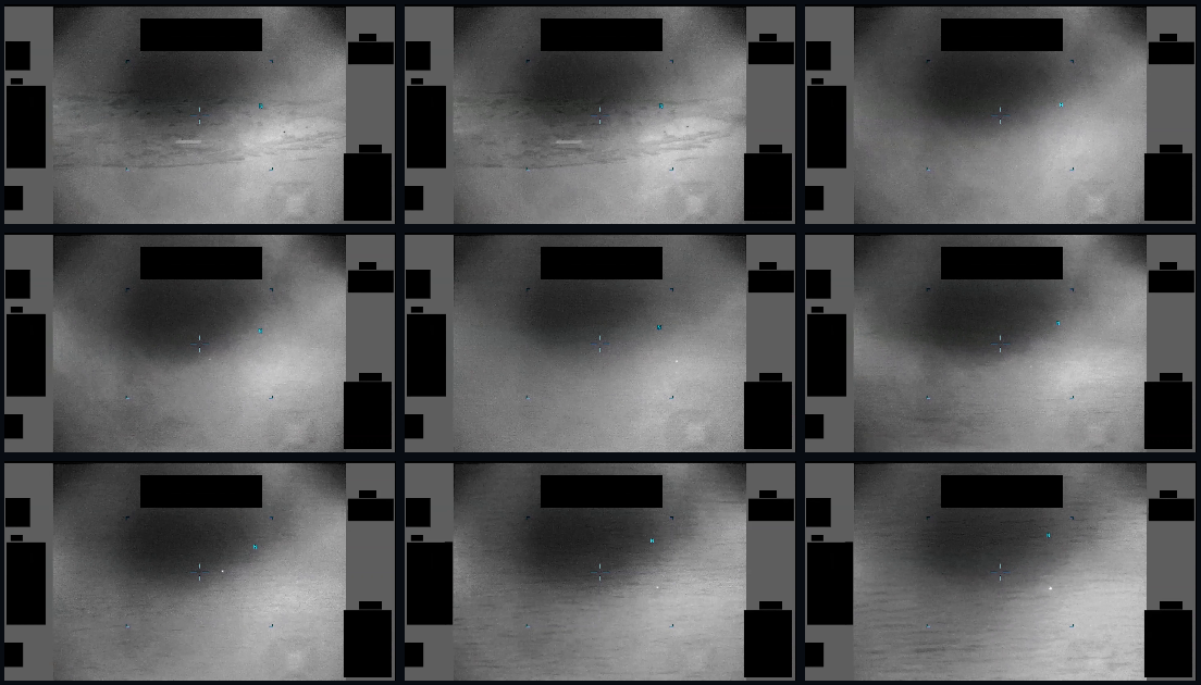
Derived full-frame review sheet sampled from the verified PR41 MP4 across the 94-second public runtime.
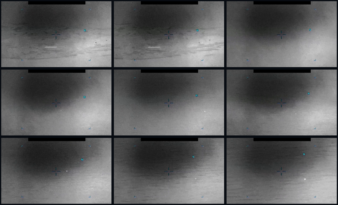
Derived center-field review sheet from the same MP4. It is a visual aid for checking the source description and display context, not separate evidence and not an identification.
The verified release-file copy is a 116,787,147-byte MP4, about 94.53 seconds long, with 1920×1080 H.264 video. The publisher description says the clip is infrared-sensor footage from a U.S. military platform in 2020; it does not provide the reporter's own oral or written description, platform track, exact coordinates, range/range-rate, or sensor calibration metadata.
Investigation reading
This draft treats PR41 as a released DVIDS MP4 and preserves the source limits. The verified Open Sky release-file copy is a 116,787,147-byte MP4 with SHA-256 ea6b86de5ec070a789e515456fb7ed2ef0bfbe536b30025117ef47cefa59c503. The media stream is 1920×1080 H.264 at 30 fps, about 94.53 seconds long, with an AAC audio stream that contains no measurable audio samples in the reviewed copy.
The official DVIDS page identifies the item as Video ID 1006094, VIRIN 200102-D-D0360-9704, filename DOD_111689083, category B-Roll, length 00:01:34, Date Taken 01.01.2020, Date Posted 05.08.2026 07:49, and location (UNDISCLOSED LOCATION). Release 01 metadata places the incident location as Arabian Gulf; the public title uses Middle East.
The official description says U.S. Central Command submitted a report to AARO consisting of one minute and 34 seconds of infrared-sensor footage from a U.S. military platform in 2020. It also states that the reporter did not provide an oral or written description. The DVIDS video description says an area of contrast enters the sensor field of view from the bottom third of the left side at 00:01, then the sensor pans left to right from 00:02 through 01:34, keeping the area generally centered. The description explicitly cautions that it is informational and should not be read as an analytical judgment or factual determination about validity, nature, or significance.
What the file appears to contain
The reviewed frames show a monochrome infrared-style sensor display with substantial video-interface material. Several solid black rectangular blocks, gray side bands, and colored cyan symbology are visible throughout the clip. Those elements appear to be display overlays, masking, or redaction/interface regions rather than scene content. A central reticle, small cyan bracket-like marks, and an N orientation marker are also visible in sampled frames.
The underlying scene is low-contrast and heavily compressed compared with original sensor data. It shows broad dark and light tonal regions, faint horizontal or slightly diagonal banding, and mottled texture. The most visible scene-level structure is a large diffuse dark-to-light contrast gradient, not a sharply bounded object.
In the early seconds, sampled lower/central frames show a short bright elongated patch or streak and small dark specks against the lighter background. From roughly the 00:20 sample onward, a compact bright point-like contrast feature is visible in the right-of-center area in multiple samples, becoming clearer in later samples around 00:45 through 01:33. The point remains unresolved in the public MP4: the released video does not provide enough detail to establish shape, distance, scale, altitude, range rate, or whether the apparent motion is independent of sensor panning, stabilization, platform movement, or video processing.
The safe visual reading is therefore narrow: this is a redacted infrared-style video showing a tracked area of contrast described by the source, plus small unresolved bright/dark contrast features visible in sampled frames. The public copy does not support an object identity, prosaic explanation, or anomalous finding on its own.
Source custody and provenance
- Official DVIDS page: DOW-UAP-PR41, Unresolved UAP Report, Middle East, 2020
- Open Sky release-file copy: MP4 release file
- DVIDS video ID:
1006094 - VIRIN:
200102-D-D0360-9704 - Filename:
DOD_111689083 - Date Taken:
01.01.2020 - Date Posted:
05.08.2026 07:49 - DVIDS location field:
(UNDISCLOSED LOCATION) - Release 01 incident location field:
Arabian Gulf - Release CSV row recorded for this video entry:
98 - Verified MP4 size/hash:
116787147bytes; SHA-256ea6b86de5ec070a789e515456fb7ed2ef0bfbe536b30025117ef47cefa59c503
The source is official-primary provenance, but it is still a public release copy, not the original sensor export. The release notes do not include platform track, coordinates, sensor calibration, range data, or the reporter's own narrative.
Graph context
The Open Sky graph has an exact VideoEvidence record for DVIDS 1006094 and a Release 01 document record for the corresponding manifest entry. The graph context preserves the title, DVIDS URL, canonical URL, Department of War agency attribution, Arabian Gulf incident-location field, and the verified MP4 hash.
The semantic layer currently has 11 extracted source-text claims and 9 entity/location/time mentions for this item, with no extracted sensor-event nodes and no table rows. Those extracted claims mostly restate source metadata: DOW-UAP-PR41, AARO, Department of War, DVIDS, Middle East, Arabian Gulf, the 2020 incident year, the 2026 release context, and the official caution that the description is not an analytic judgment.
Graph neighbors include PR38, another DVIDS video titled DOW-UAP-PR38, Unresolved UAP Report, Middle East, 2013, and a related Release 01 document entry for PR44, DOW-UAP-PR44, Unresolved UAP Report, Middle East, 2020. Candidate crosslinks also point to broad Middle East or Unresolved UAP Report matches, including other DVIDS and public-report sources. Those are navigation and review leads only; they are not corroboration and not findings.
There is a provenance cleanup lead in the row numbering: this video entry is recorded with Release CSV row 98, while the graph release-record anchor for the corresponding document context is around current row 95. That mismatch should be reconciled against the Release 01 CSV and WAR.GOV landing-page ordering before using row numbers as citations.
Leads to check
- Obtain or locate any original sensor export, unredacted frame sequence, platform track, range/range-rate, field-of-view, stabilization, and sensor calibration metadata.
- Reconcile the
Arabian Gulfrelease-location field with the DVIDS(UNDISCLOSED LOCATION)field and the genericMiddle Eastpublic title. - Compare PR41 with adjacent Release 01 Middle East 2020 records, especially PR44 and other 2020 DVIDS videos, to see whether they share date, platform, collection context, or only broad title/location language.
- Check whether AARO, CENTCOM, DVIDS, or WAR.GOV published any companion mission report, transcript, stills, or revised metadata for DVIDS
1006094. - If an exact collection time and coordinates become available, run ordinary-context checks: air and maritime traffic, weather and visibility, astronomy, satellite/reentry/launch activity, drones, balloons, flares, birds, debris, surface lights, and sensor/display artifacts.
- Review the small bright point-like feature against the full frame sequence for fixed-pixel behavior, compression blocks, stabilization drift, masking edges, automatic gain changes, and overlay interactions before treating it as physical scene content.
- Reconcile Release CSV row
98versus the graph release-record row anchor before citing row-level provenance publicly.
Lead check notes
- Blocked — Source telemetry package: the current public PR41 sources expose the MP4 and publisher metadata, but not the original sensor export, unredacted frame sequence, platform track, field-of-view, stabilization data, range/range-rate, or sensor calibration.
- Partial — Location and date metadata: DVIDS lists the location as
(UNDISCLOSED LOCATION), the public title saysMiddle East, and Release 01 metadata saysArabian Gulf. The linked public record does not expose coordinates or a precise collection date beyond the 2020 incident year / DVIDS Date Taken field. - Partial — Adjacent Middle East 2020 records: current linked Release 01 records group PR37, PR39, PR40, PR41, PR42, and PR44 as video-only Middle East/Arabian Gulf 2020 items with no oral or written observer description in the manifest text. That supports comparison, but it does not establish a shared platform, collection, or event.
- Partial — Companion material: the linked Release 01 video record for DVIDS
1006094exposes an MP4 only; no PR41-specific mission report, still image, transcript, or revised metadata is present in the current Open Sky release records. - Needs external source — Ordinary-context checks: air and maritime traffic, weather and visibility, astronomy, satellite/reentry/launch activity, drones, balloons, flares, birds, debris, surface lights, and sensor/display-artifact checks require exact collection time, coordinates, platform geometry, and line of sight.
- Partial — Visual-feature review: sampled-frame review supports only cautious language. A compact bright point-like contrast feature appears in several later sampled frames, but fixed-pixel behavior, compression, stabilization drift, automatic gain, masking edges, and display processing cannot be ruled out from the public MP4 alone.
- Partial — Row provenance: Release 01 video metadata carries row
98, while graph/landing-page record context can surface a current-row anchor around95. Keep row numbers as provenance-cleanup leads until the CSV and landing-page ordering are reconciled.
Limits
This page does not assert a finding, hypothesis, or resolution. The release provides a public MP4 and source metadata, but no exact event time beyond 2020, no coordinates, no reporter narrative, no raw telemetry, no sensor calibration, and no independent corroborating sensor record in this page. The audio track in the reviewed copy is silent. The public video is redacted/masked and includes display overlays; those elements must be separated from underlying scene content.
The visual feature remains unresolved at public-release resolution. A small bright point or broader contrast patch in an infrared-style frame can have many ordinary or sensor-related explanations without the geometry and raw collection context needed to discriminate among them. Candidate graph crosslinks are review prompts only.
Deep investigation — graph + web reconnaissance
Source reread
PR41 remains a video-only official-primary item. The verified release-file copy is a 116,787,147-byte MP4 with SHA-256 ea6b86de5ec070a789e515456fb7ed2ef0bfbe536b30025117ef47cefa59c503; the MP4 header begins with an ftyp box, and the media stream is about 94.53 seconds of 1920×1080 H.264 at 30 fps with a silent AAC audio track. The live DVIDS page for video 1006094 returned 200 during this check and preserved the PR41 title, VIRIN 200102-D-D0360-9704, filename DOD_111689083, Date Posted 05.08.2026 07:49, and length 00:01:34. A direct range request to the DVIDS CloudFront MP4 returned 206 bytes 0-2047/116787147, matching the public release-file byte total.
The publisher description is narrow: U.S. Central Command submitted one minute and 34 seconds of infrared-sensor footage from a U.S. military platform in 2020; the reporter did not provide an oral or written description. The source description says an area of contrast enters from the bottom third of the left side at 00:01, then from 00:02 through 01:34 the sensor pans left-to-right while generally keeping that area centered. The same description says it is informational only and not an analytic judgment, investigative conclusion, or factual determination.
Media reread
Representative full-frame and lower/central crop review supports the existing cautious visual posture. The public MP4 shows a monochrome infrared-style display with black mask/redaction blocks, gray side panels, cyan reticle/bracket symbology, and an N orientation marker that should be treated as interface/display material, not scene content. The visible scene is diffuse and low-contrast, with broad dark/light regions and mottled texture rather than a sharply bounded object.
A tiny bright point-like contrast feature is visible in several later samples, especially after roughly 00:30 and more clearly near 01:00 through the end of the clip, but it remains unresolved at public-release resolution. Its apparent path cannot be converted into speed, altitude, range, or object identity because the source does not expose range, field of view, platform motion, stabilization state, sensor calibration, or unredacted telemetry. Fixed-pixel or display-coordinate artifacts, compression, automatic gain/display processing, sensor panning, stabilization, and platform motion remain live confounders until original sensor data and metadata are available.
Graph connections
Read-only Neo4j review found the stable graph identity as VideoEvidence DVIDS 1006094, with the DVIDS canonical URL, CloudFront MP4 URL, 116,787,147-byte full download, matching SHA-256, source agency Department of War, incident location field Arabian Gulf, and related CSV row 98. The exact video node has one manifest-description text chunk, 11 machine-extracted Claim nodes, 9 EntityMention nodes, and 0 SensorEvent nodes for this asset. Those machine extractions mainly restate source metadata and the publisher caution; they remain machine_extracted_needs_human_review / not_a_finding unless verified against the source text.
The graph also surfaced a manifest-hygiene issue rather than corroboration: a PR41-titled release-record row can carry stale PR38 URL/HTML context, while a row-98 PR44-titled record can carry PR41 URL/HTML context. The exact video node's DVIDS ID, URL, hash, byte total, and row list are therefore the safer identifiers for this page. Neighboring Middle East 2020 videos such as PR38/PR44 are comparison and cleanup leads only; they do not establish a shared event, platform, or explanation.
External provenance and prosaic checks
Official/live-source checks were mixed. DVIDS and the CloudFront MP4 were reachable and matched the expected public metadata/byte count; the WAR.GOV landing page and current CSV URL returned 403 Access Denied from this environment. Internet Archive availability showed a DVIDS page snapshot at 20260517141207; no availability hit was returned for the CloudFront MP4 or WAR.GOV landing page during this check.
Because PR41 exposes only broad 2020 / (UNDISCLOSED LOCATION) / Arabian Gulf / Middle East metadata, ordinary correlation checks are not yet probative. Weather, astronomy, launch/reentry, satellite, air-traffic, maritime, drone/balloon/flare, and surface-light checks require exact collection date/time, coordinates, platform position, line of sight, altitude/range context, and sensor mode. The graph contains WeatherEvent, AstronomyEvent, and LaunchEvent labels, while Satellite is present with zero nodes, but the PR41 source does not provide enough specific time/location information to use those datasets as exclusions.
Follow-up leads and audit note
The most important next steps are to obtain the original or less-compressed sensor export; unredacted telemetry and display fields; platform track, field of view, range/range-rate, and stabilization/gimbal state; any CENTCOM/AARO mission-report companion; and a reconciled Release 01 row map for the PR41/PR44/PR38 manifest drift. Until those are available, PR41 should remain a documented official video release with an unresolved visible contrast feature, not a resolved identification or an anomalous finding.
This deep check used source reread, media-frame review, official/archive web probes, and read-only graph queries only. No graph writes or finding/hypothesis/resolution claims were made.
Sources
- DVIDS: DOW-UAP-PR41, Unresolved UAP Report, Middle East, 2020
- Open Sky release-file MP4: war-gov-dow-uap-pr41-unresolved-uap-report-middle-east-2020-1006094
- WAR.GOV PURSUE Release 01 landing page and CSV manifest, source dataset
war_pursue_uap_release_2026_05_08. - Open Sky semantic graph context, semantic dataset
war_pursue_release01_semantic_2026_05_12; review statusgraph_investigation_draft; investigation statusneeds_human_review; finding statusnot_a_finding.