DOW-UAP-PR44, Unresolved UAP Report, Middle East, 2020
Evidence media
- Open Sky release-file MP4: DOW-UAP-PR44, Unresolved UAP Report, Middle East, 2020
- Official DVIDS video page
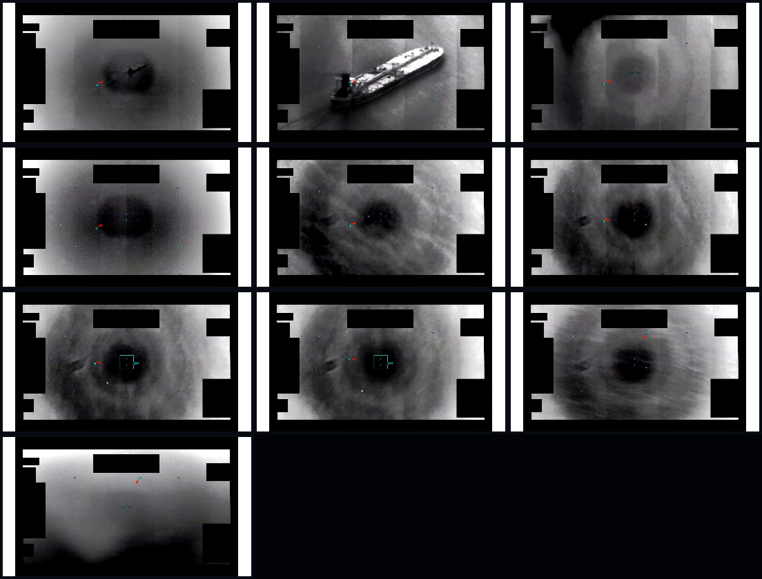
Derived full-frame review sheet sampled from the verified PR44 MP4 across the opening, tracking, reticle-cycle, and late-clip segments.
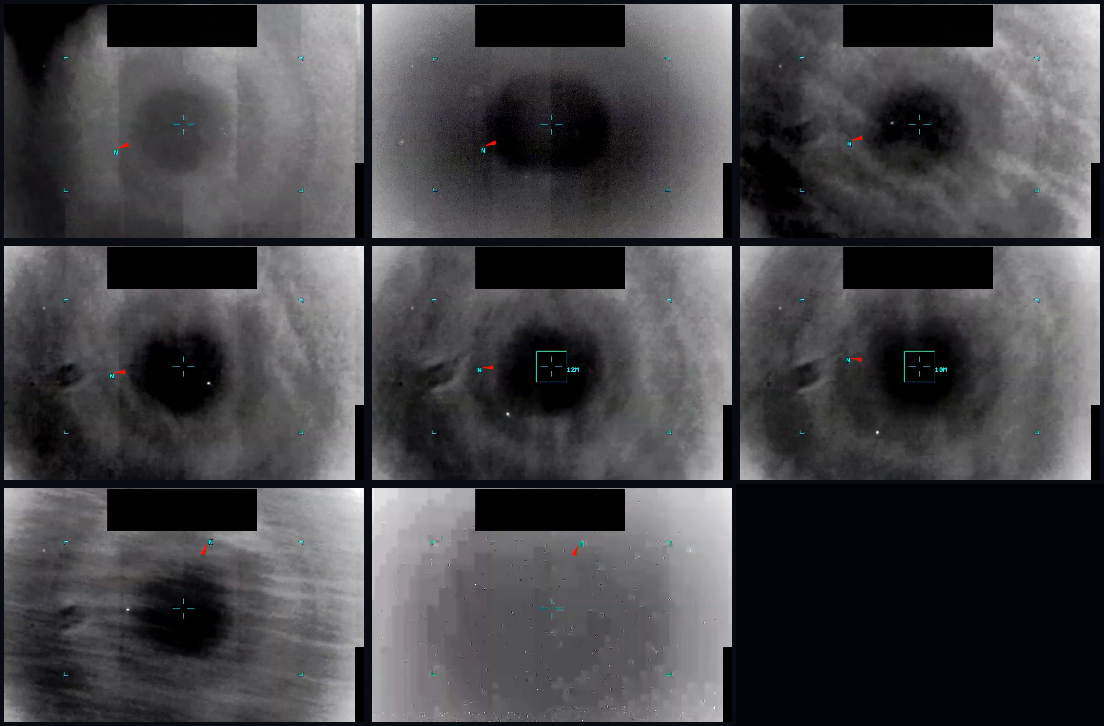
Derived center-track review sheet from the same MP4. It is a visual aid for source review, not a separate source and not an Open Sky identification of the contrast area.
The verified release-file copy is an 86,775,527-byte MP4 with 1920×1080 H.264 video at 30 fps and a measured runtime of about 312 seconds. The publisher description says the clip is infrared-sensor footage from a U.S. military platform in 2020 and cautions that the interval notes are informational, not an analytical judgment; the public record does not include the original sensor export, platform geometry, range data, or the reporter's own oral/written description.
Investigation reading
This draft treats PR44 as a public-release video record, not as a resolved case. The reviewed source is the public DVIDS MP4 for Video ID 1006104, titled by the release as DOW-UAP-PR44, Unresolved UAP Report, Middle East, 2020. The Open Sky release-file copy is 86,775,527 bytes and verifies to SHA-256 9db22223a0384d0439235fe6583cb5be5e7fd38f0d040fec8402ba2edbedd883.
The MP4 is H.264 video at 1920×1080, 30 fps, with a measured runtime of about 312 seconds (00:05:12). It includes an AAC stereo audio stream; the official DVIDS description says the recorded audio is incidental and does not relate to the visual content, so the audio is not treated here as evidence for the visual observation.
The visual pass covered the full public runtime through one-frame-per-second review sheets from 0–311 seconds, plus denser samples in the tracking and end-of-track portions. The source description was read against those samples. The page below keeps the video-level observations modest because the public MP4 lacks raw sensor telemetry, exact platform geometry, range, field of view, and the original uncompressed sensor export.
What the file appears to contain
The video is a monochrome/infrared-style sensor display over a maritime scene. Fixed black masks, side framing elements, and a top black rectangle obscure parts of the display. Small colored marks, central reticles, and later a green tracking box appear to be sensor or display symbology, not physical scene objects.
The official description says 00:00–00:30 contains no content. In the public MP4 samples, this interval still shows sensor imagery over water, including a clearly visible large vessel from roughly 7–28 seconds. The safest reading is that the source means no relevant UAP/tracking content is presented in that opening segment, not that the video is literally blank. No separate unresolved target is obvious in that first half-minute.
From about 00:31 onward, the sensor view shifts to a broad dark circular or oval area of contrast against a gray water/background field. Across the 1-fps pass from roughly 00:40–03:20, the central feature remains soft-edged and extended rather than a crisp point target. Its shape and contrast vary with the background, gain, compression, or sensor behavior. There are intermittent tiny bright specks in some frames, but they are not consistently centered or stable enough in the reviewed public samples to describe as a separate object.
Around the reticle/track segment, a green box becomes visible in sampled frames near the central dark feature. The official description says the sensor cycles reticles from 03:25–04:23; the visual samples show a tracking-box/reticle phase in that general late-middle portion, with the box close to the broad dark region rather than resolving a structured craft or object. The feature remains visually unresolved: no wings, hull, exhaust, control surfaces, or stable geometric structure can be identified from the public copy.
During the late segment after about 04:24, the scene appears to widen or change while the same dark contrast area remains visible for a time. The tracking overlay is no longer apparent in the final sampled stretch. The official description says the area of contrast exits the frame around 04:50–04:54; sampled frames near the end are consistent with loss of the prior tracked feature, but they do not independently prove an exact exit path or cause. By the final seconds, the prior central contrast feature is no longer clearly visible.
Source custody and provenance
DVIDS identifies the video as Video ID 1006104, VIRIN 200102-D-D0360-8501, filename DOD_111689115, category B-Roll, length 00:05:12, date taken 01.01.2020, and date posted 05.08.2026 07:49. DVIDS lists the location as (UNDISCLOSED LOCATION). Release metadata and graph records use Arabian Gulf / Middle East, 2020 as the incident-location/title context, so the exact geography should remain a provenance lead until reconciled against source records with coordinates or platform context.
The release description attributes the submission to United States Central Command and says the report went to AARO. It also states that the reporter did not provide an oral or written description of the observation. The public record therefore consists primarily of the video file and publisher description; it does not include witness narrative, sensor logs, a mission report, range data, or an analytical determination.
The public Open Sky file endpoint should serve the same MP4 identified above. The official page and the direct DVIDS media file agree on the byte size for the public MP4, and the release-file hash is preserved in this page for repeatability: 9db22223a0384d0439235fe6583cb5be5e7fd38f0d040fec8402ba2edbedd883.
Graph context
The graph currently represents PR44 as a VideoEvidence record and as a related Release 01 document/manifest record. It preserves the official DVIDS page, DVIDS ID 1006104, the public MP4 hash, title, agency, and release provenance. The semantic layer has 15 extracted claim records, 9 entity mentions, 0 extracted sensor-event records, and 0 table rows for this item.
Those extracted claims are mostly source-description and identity facts: AARO, Department of War, DVIDS, the report ID, Middle East, Arabian Gulf, 2020, and the publisher's interval description. They are useful navigation cues, not findings. The graph does not currently add independent sensor corroboration for PR44.
Two relationship edges are worth checking as context only: a same-family Middle East 2020 video page, DOW-UAP-PR41, and a related INDOPACOM 2023 release record, DOW-UAP-PR47. These links should not be treated as corroboration until the underlying records are compared at the source level.
Leads to check
- Reconcile row/provenance numbering: the selected video metadata lists CSV row
101, while the graph's release-record document is anchored to current row98. - Clarify the location chain: DVIDS lists
(UNDISCLOSED LOCATION), while Release 01 metadata saysArabian Gulfand the title saysMiddle East, 2020. - Locate any companion mission report, platform log, or AARO submission record that would provide exact date/time, aircraft or sensor type, coordinates, altitude, slant range, field of view, stabilization state, and sensor polarity.
- Check why the opening
00:00–00:30interval is described asNo contenteven though the public MP4 visibly contains maritime sensor imagery and a vessel. - Compare PR44 with PR41 and nearby Release 01 Middle East 2020 videos for shared source family, overlay style, row numbering, and whether any clip has a paired written report.
- Test ordinary-context explanations only after geometry is available: vessel wake or plume, water-temperature contrast, cloud/haze, glare or vignetting, gain/focus cycling, compression, display artifact, sensor stabilization behavior, and maritime/air traffic context.
Lead check notes
- Checked — Media/source identity: the Open Sky release-file copy verifies as DVIDS
1006104/ VIRIN200102-D-D0360-8501, 86,775,527 bytes, SHA-2569db22223a0384d0439235fe6583cb5be5e7fd38f0d040fec8402ba2edbedd883; the official DVIDS page and the release-file link point to the same public MP4 record. - Partial — Row/provenance numbering: Release 01 video metadata lists row
101, while the graph release-record anchor for the companion manifest record is current row98. Keep row numbers as provenance-cleanup leads until the CSV/landing-page order and graph record are reconciled. - Partial — Location chain: DVIDS lists
(UNDISCLOSED LOCATION), the public title saysMiddle East, 2020, and Release 01 metadata usesArabian Gulf. The current public record does not expose coordinates, platform track, or collection geometry to narrow that geography. - Blocked — Companion source package: the linked PR44 materials expose the MP4 and publisher metadata, but not a mission report, original sensor export, unredacted frame sequence, platform log, sensor model/settings, range/range-rate, field of view, or AARO submission packet.
- Partial — Opening
00:00–00:30wording: the source description saysNo content, while the public MP4 visibly contains maritime sensor imagery and a vessel. The safest current reading is “no relevant UAP/tracking content,” but the publisher wording itself remains unexplained without a source note or production record. - Partial — Adjacent video comparison: current Release 01 metadata groups PR37, PR39, PR40, PR41, PR42, and PR44 as video-only Middle East/Arabian Gulf 2020 records; the reviewed PR41 page is the closest human-read comparison, while the PR47 graph neighbor is still only a source-context lead. None of those links establishes a shared platform, collection, or event for PR44.
- Needs external source — Ordinary-context checks: vessel wake/plume, water-temperature contrast, cloud/haze, glare/vignetting, gain/focus cycling, compression, display artifact, stabilization behavior, maritime/air traffic, weather, satellite/reentry/launch, drone, balloon, bird, or debris checks require exact time, coordinates, platform/sensor geometry, and original or less-compressed collection data.
Deep investigation — graph + web reconnaissance
Source and media reread
The source record remains a video-only public release, not a complete mission packet. The verified release-file MP4 is 86,775,527 bytes and SHA-256 9db22223a0384d0439235fe6583cb5be5e7fd38f0d040fec8402ba2edbedd883; the direct public media URL also answered a range request with bytes 0-31/86775527 and MP4 ftyp magic. The live DVIDS page was reachable and preserved the same basic custody fields: Video ID 1006104, VIRIN 200102-D-D0360-8501, filename DOD_111689115, B-Roll, date taken 01.01.2020, date posted 05.08.2026 07:49, length 00:05:12, and location (UNDISCLOSED LOCATION).
A representative frame reread supports the earlier page reading. The opening samples visibly show a vessel on water, even though the publisher interval label says 00:00-00:30: No content; that wording is safest read as no relevant UAP/tracking content, not a blank clip. Later samples show a broad soft-edged dark circular/oval contrast region, mottled water/background texture, intermittent tiny bright specks, and central reticle/tracking-box overlays. Black redaction/mask blocks, cyan reticles, red marks, borders, and display framing are overlay/display elements and should not be treated as scene objects.
Graph connections and extraction quality
The graph has an exact VideoEvidence match for DVIDS 1006104 with the same title, canonical DVIDS URL, MP4 byte count, SHA-256, Release 01 row context [101], incident date N/A, and incident location Arabian Gulf. It also has a Release 01 manifest Document row anchored to current row 98 for PR44, while a neighboring row 101 document carries PR47 title fields but PR44 final-URL/body-hash fields. That is a row/final-URL reconciliation lead, not evidence that PR44 and PR47 are the same event.
Semantic extraction coverage for this video is limited: 15 machine-extracted Claim nodes and 9 EntityMention nodes, with no SensorEvent nodes and no CANDIDATE_CROSSLINK edges returned for the exact video asset. The extracted claims are all marked machine_extracted_needs_human_review and not_a_finding; they mostly repeat source identity, AARO/Department of War/DVIDS organization mentions, Middle East/Arabian Gulf, 2020, and the publisher's interval description. They are useful navigation and provenance aids, not independent corroboration or analysis.
External provenance and official-source checks
Official-source custody is strongest at DVIDS for this item: the public DVIDS page is live, and the CloudFront media object serves the expected byte range for the 86,775,527-byte MP4. WAR.GOV/PURSUE landing and CSV probes returned 403 during this check, which is an access/custody limitation rather than a contradiction because the cached Open Sky copy and DVIDS media object both verify. Internet Archive availability shows a DVIDS page snapshot from 20260517141702 and a WAR.GOV UFO landing-page snapshot from 20260519012013; those are provenance leads, not substitutes for hash-matched official media.
No companion mission report, original sensor export, platform log, unredacted frame sequence, range/range-rate record, sensor model/settings sheet, or AARO analytical packet surfaced in the source reread or graph query. Nearby PR37/PR39/PR40/PR41/PR42/PR44 Middle East/Arabian Gulf video records remain same-release comparison leads only; they do not establish a shared platform, same event, or corroborating observation without source-level alignment.
Prosaic checks and open questions
The public metadata gives only a broad 2020 date and (UNDISCLOSED LOCATION) / Arabian Gulf location context, so astronomy, weather, launch, satellite, maritime-traffic, air-traffic, bird/balloon/drone, and sensor-artifact checks cannot be meaningful exclusions yet. The first ordinary lanes to preserve are vessel/wake or plume, water-temperature contrast, cloud/haze, gain/focus/zoom cycling, glare or vignetting, compression, display/reticle behavior, and platform/sensor stabilization. Those checks require exact time, coordinates, look geometry, platform motion, sensor mode, field of view, and preferably the original or less-compressed sensor product.
Audit note
This section adds source-grounded graph and web reconnaissance only. It does not identify the contrast area, convert machine extractions into findings, or assert a resolution. PR44 remains a public MP4 with verified provenance and unresolved source-context gaps.
Limits
This page does not identify the contrast area, estimate speed, infer altitude or range, or decide whether the feature is anomalous. The public MP4 is compressed and overlaid; parts of the sensor display are masked; exact sensor settings and platform motion are missing. The reviewed frames show a broad, soft-edged area of contrast that is tracked or centered for part of the clip, but the public copy does not resolve it into a specific object type.
The official description itself warns that its interval notes are informational and should not be read as an analytical judgment, investigative conclusion, or factual determination. This draft follows that posture: PR44 remains needs_human_review and not_a_finding.
Sources
- Official DVIDS page: https://www.dvidshub.net/video/1006104/dow-uap-pr44-unresolved-uap-report-middle-east-2020
- Open Sky release-file MP4: /api/explore/war-gov/release-file/war-gov-dow-uap-pr44-unresolved-uap-report-middle-east-2020-1006104
- WAR.GOV PURSUE Release 01 landing page: https://www.war.gov/UFO/
- WAR.GOV PURSUE Release 01 CSV manifest: https://www.war.gov/Portals/1/Interactive/2026/UFO/uap-csv.csv