DOW-UAP-PR45, Unresolved UAP Report, Middle East, 2020
Evidence media
- Open Sky release-file MP4
- Official DVIDS source page
- Derived frame-review aids from the official MP4: full-frame timeline samples and center/lower-right timeline crop samples.
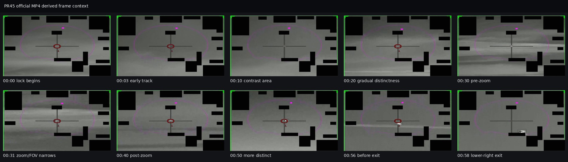
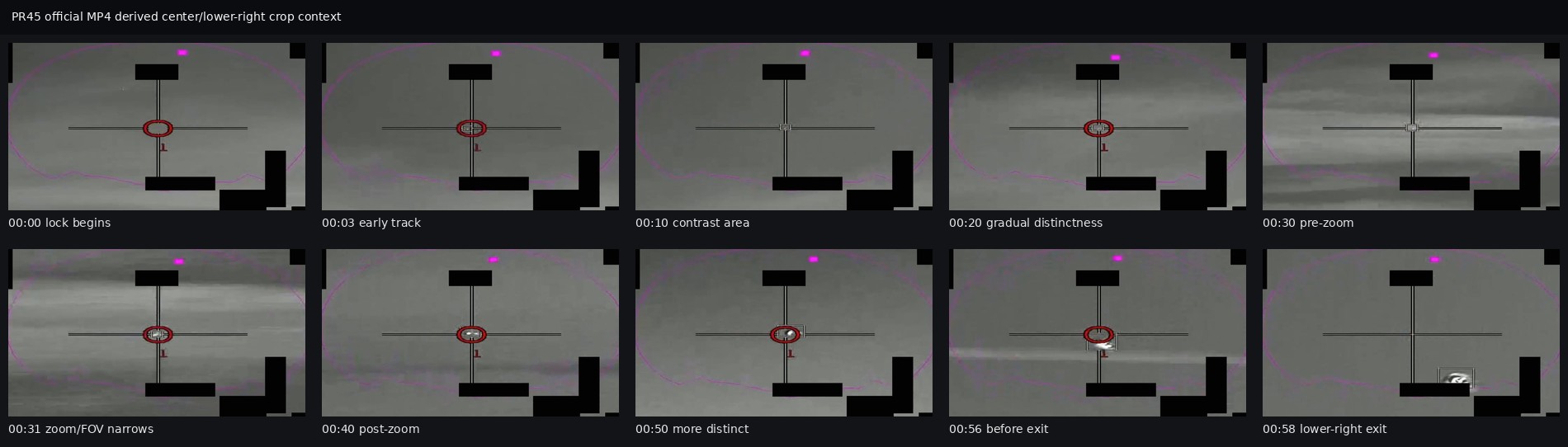
The Open Sky release-file copy is the verified public DVIDS MP4: 14,908,599 bytes, H.264 video, 1920×1080, approximately 58.77 seconds, with SHA-256 30d4ecc8af56475042a65e52e5910be9d95e3cb08e397293fb52885ba23e9b6e. The contact sheets are derived review aids from that MP4, not separate source evidence. They show the publisher-described timeline points, including a faint contrast feature becoming more visible after the field-of-view change around 00:31 and approaching or becoming obscured near the lower-right visible edge around 00:58; they do not establish range, scale, speed, altitude, or object type.
Investigation reading
This release item is a short DVIDS MP4, not a PDF packet or witness statement. The verified released media is a 14,908,599-byte H.264 MP4, 1920 × 1080 pixels, 30 fps, with a runtime of about 58.77 seconds. The file hash verified against Release 01 metadata is 30d4ecc8af56475042a65e52e5910be9d95e3cb08e397293fb52885ba23e9b6e. The container includes an AAC stereo audio stream, but audio analysis found it effectively silent at about -91 dB; there is no useful narration or cockpit audio in the released file.
DVIDS lists the video as DOW-UAP-PR45, Unresolved UAP Report, Middle East, 2020, video ID 1006105, VIRIN 200102-D-D0360-7322, filename DOD_111689123, category B-Roll, length 00:00:58, date taken 01.01.2020, date posted 05.08.2026 07:50, and location (UNDISCLOSED LOCATION). The Release 01 metadata and graph record also surface Southern United States as an incident-location field, so the public title, DVIDS location field, and Release 01 location metadata do not cleanly agree.
The official description says the footage came from an infrared sensor aboard a U.S. military platform in 2020 and that the reporter supplied no oral or written description of the observation. It describes a contrast area being tracked from 00:00–00:03, becoming more distinctive through 00:30, a field-of-view narrowing/zoom at 00:31, continued increase in apparent size/distinctiveness through 00:56, and departure from the center of the frame/out of the sensor field-of-view at 00:57–00:58. The AARO comment says the apparent increase in size is likely at least partly attributable to the U.S. platform closing distance to the detection source.
A full-frame and center-crop frame review of the released MP4 shows a grayscale infrared sensor scene with a reticle/crosshair, black masked display regions, colored display/annotation elements, and a small unresolved contrast feature near the reticle for much of the clip. The feature is faint early, becomes more distinct against changing gray background bands, is visually more prominent after the reported zoom, and shifts away from the reticle near the end. In the last sampled frames, a bright compact irregular feature remains near the lower part of the visible image close to a black masked region, so the cleanest public wording is that the feature leaves the center/tracking area and approaches or passes out of the shown field near the end. The released footage does not show stable object-identifying detail such as wings, fuselage, rotors, plume, balloon envelope, control surfaces, or surface markings.
What the file appears to contain
The file appears to contain a single infrared sensor clip with release/display overlays. The original scene content is low-contrast grayscale imagery with broad horizontal tonal bands and no clear ground reference, horizon, recognizable terrain, or landmarks. The overlays and display elements are important: the reticle, central tracking/annotation marks, black masks, colored arcs/markers, and frame symbology are not the same thing as the underlying scene.
The visible target-like content is best described as an unresolved infrared contrast feature. It remains small throughout the clip and changes from a faint compact patch to a brighter, more conspicuous patch as the background and sensor presentation change. The available video supports a cautious read-through of what the official description says, but it does not by itself establish size, range, speed, altitude, identity, or independent motion through space.
Source custody and provenance
- Official DVIDS page: https://www.dvidshub.net/video/1006105/dow-uap-pr45-unresolved-uap-report-middle-east-2020
- Open Sky release-file MP4: war-gov-dow-uap-pr45-unresolved-uap-report-middle-east-2020-1006105
- Agency: Department of War
- Source/container kind: video
- DVIDS video ID:
1006105 - DVIDS filename:
DOD_111689123 - Verified release-file SHA-256:
30d4ecc8af56475042a65e52e5910be9d95e3cb08e397293fb52885ba23e9b6e - Verified release-file size:
14,908,599bytes
The source custody is official-primary, but the metadata has review issues. The graph release-record node points to a WAR.GOV Release 01 manifest record at row 99, while the video source metadata and semantic graph records carry related CSV row 102. The title says Middle East, 2020; DVIDS displays (UNDISCLOSED LOCATION); and Release 01 metadata surfaces Southern United States. Those tensions should be treated as provenance-cleanup leads rather than resolved geography.
Graph context
The graph has an exact VideoEvidence record for DVIDS 1006105 and an exact Release 01 manifest Document record for this item. The semantic extraction currently reports 11 extracted claims, 9 entity mentions, 0 sensor-event nodes, and 0 table rows. The extracted claim categories are mostly release description, document identity, location/time metadata, and agency names. The graph does not provide an independent sensor track, platform telemetry, or corroborating observation narrative.
Two related graph neighbors appear as navigation context: DOW-UAP-PR42, Unresolved UAP Report, Middle East, 2020 and DOW-UAP-PR48, Unresolved UAP Report, INDOPACOM, 2024. There are no candidate crosslinks for this asset in the current context output. These links should be used for follow-up comparison only, not as evidence that the events are the same.
Leads to check
- Reconcile the row-number and location metadata: Release 01 row
99vs video row102, titleMiddle East, Release 01 locationSouthern United States, and DVIDS location(UNDISCLOSED LOCATION). - Compare PR45 with PR42 and PR48 only after checking their source media and metadata separately.
- Locate any underlying report, platform/sensor metadata, tracking geometry, unmasked display data, or analyst notes that explain range, closure, field-of-view, zoom state, and line-of-sight changes.
- Recheck the final second against the original video frame-by-frame to clarify whether the feature exits the full sensor frame, the center/tracking area, or only the cropped/visible region near the black mask.
- Test ordinary explanations before escalation: sensor gain/contrast changes, background cloud or atmospheric texture, glare/processing artifacts, range closure, and platform motion.
Lead check notes
- Checked — released MP4 identity: The Open Sky release-file copy matches DVIDS video ID
1006105, filenameDOD_111689123, size14,908,599bytes, and SHA-25630d4ecc8af56475042a65e52e5910be9d95e3cb08e397293fb52885ba23e9b6ein Release 01 metadata. - Partial — row and location provenance: Current graph context preserves a WAR.GOV release-record anchor at row
99, while the video source metadata carries related CSV row102; the title saysMiddle East, 2020, DVIDS says(UNDISCLOSED LOCATION), and Release 01 metadata surfacesSouthern United States. This remains a provenance-cleanup issue, not resolved geography. - Partial — adjacent-video comparison: PR42 is a separate DVIDS
1006097Middle East 2020 video already suitable for source-series comparison; PR48 is an INDOPACOM 2024 item and its current wiki page is still machine-extracted. Current PR45 graph context reports no candidate crosslinks, so these are navigation/comparison leads only. - Partial — final-second visual review: The official-MP4 contact sheets sample the publisher-described timeline, including
00:56and00:58. They support cautious wording that the contrast feature leaves the center/tracking area and approaches or becomes obscured near the lower-right visible edge, but they do not prove whether it exits the full sensor field versus a masked/cropped display region. - Blocked — original sensor and platform context: The public release does not include the original platform export, unmasked frames, sensor calibration, field-of-view/gain state, range/range-rate, pointing geometry, platform motion, or analyst notes needed for quantitative tracking.
- Needs external source — ordinary-context checks: Sensor gain/contrast changes, atmospheric/cloud background, glare or display-processing artifacts, compression/stabilization behavior, aircraft/bird/drone/debris alternatives, weather, traffic, and line-of-sight checks require exact time, coordinates, platform geometry, and original sensor data not present in the public MP4.
Deep investigation — graph + web reconnaissance
Source reread
The live DVIDS page for video 1006105 returned the PR45 record during this check, with title DOW-UAP-PR45, Unresolved UAP Report, Middle East, 2020, VIRIN 200102-D-D0360-7322, filename DOD_111689123, date taken 01.01.2020, date posted 05.08.2026 07:50, location (UNDISCLOSED LOCATION), and length 00:00:58. The CloudFront MP4 range request returned 206 with Content-Range: bytes 0-2047/14908599 and MP4 ftyp bytes, matching the verified 14,908,599-byte Open Sky release-file copy and SHA-256 30d4ecc8af56475042a65e52e5910be9d95e3cb08e397293fb52885ba23e9b6e.
WAR.GOV landing and current/legacy CSV probes returned 403 Forbidden, so the cached official-primary release file plus DVIDS/CloudFront checks remain the strongest public custody path for this run. Internet Archive availability showed a DVIDS page snapshot at 20260517141756; the CDX probe was unavailable (503), and no archived MP4 hash was substituted for the verified release-file copy.
Graph connections
The graph has two exact PR45 anchors: a VideoEvidence node for DVIDS 1006105 and a WAR.GOV Release 01 manifest Document record. The stable video asset carries related CSV row 102, the DVIDS canonical URL, CloudFront MP4 URL, the verified byte count/hash, incident date N/A, and Release 01 incident-location metadata Southern United States. The manifest Document is marked current at row 99, but its final-URL/html-title fields still point at PR42; that is a row/final-URL hygiene issue, not corroboration that PR42 and PR45 are the same event.
Semantic graph coverage is limited but useful for audit: 11 machine-extracted Claim nodes, 9 EntityMention nodes, 1 Location node, 0 SensorEvent nodes, 1 direct video text chunk, and 0 exact CANDIDATE_CROSSLINK records. The claim kinds are agency, document identity, location, time, motion/measurement, and a source-disclaimer statement; all are marked machine_extracted_needs_human_review / not_a_finding. One automatically labeled witness_testimony claim is actually the public disclaimer warning readers not to treat the description as an analytical judgment, so it should not be treated as witness testimony.
The only direct RELATED_TO neighbor from the exact video asset in the graph is a PR48 manifest record through manifest_dvids_video row metadata. PR42 appears through stale PR45 row-record URL/title fields and as adjacent series context, but neither PR42 nor PR48 establishes a shared platform, same event, or corroborating observation without source-level proof.
Media and prosaic checks
The existing full-frame and center/lower-right contact sheets are preserved as derived review aids from the public MP4. They support cautious visual language only: a small unresolved contrast feature is held near the reticle for much of the clip, appears more distinct after the 00:31 field-of-view/zoom change, and is associated with a lower-right exit/obscuration region near the end. The imagery also contains prominent reticle graphics, black masks/redactions, colored overlays, compression, and changing gray background bands, none of which should be confused with physical scene content.
The first ordinary/prosaic lanes remain sensor-and-context checks rather than conclusions: platform closure (which AARO itself flags as at least a partial explanation for apparent size increase), field-of-view/gain changes, stabilization/tracking behavior, compression around the reticle, display overlays/masks, and low-contrast background/cloud or atmospheric texture. Weather, astronomy, launch, satellite, drone, bird, aircraft, or debris correlation is not meaningful yet because the public release lacks exact date/time, coordinates, platform track, pointing geometry, range/range-rate, and raw sensor export.
Follow-up leads and audit note
Priority follow-ups are the underlying Department of the Air Force/AARO report, the original sensor export or less-compressed frames, unmasked display data, platform identity/track, sensor model/FOV state, range/range-rate, and reconciliation of row 99 vs row 102 plus Middle East / (UNDISCLOSED LOCATION) / Southern United States metadata. No Finding, Hypothesis, or ResolutionDecision is asserted here; PR45 remains an official video record with an unresolved contrast feature and unresolved provenance/context gaps.
Limits
This draft does not identify the object and does not assert a finding. The released file has no accompanying oral or written observation narrative, no known location, no platform identity, no range, no altitude, no speed, no azimuth/elevation history, no weather context, and no raw sensor telemetry. The MP4 contains a highly annotated display image, not a clean sensor export. The visible feature is unresolved and can be described only as a contrast feature in released infrared video until additional source material is available.
Sources
- DVIDS official video page,
DOW-UAP-PR45, Unresolved UAP Report, Middle East, 2020, video ID1006105. - Open Sky release-file MP4: /api/explore/war-gov/release-file/war-gov-dow-uap-pr45-unresolved-uap-report-middle-east-2020-1006105
- Release 01 metadata and SHA-256 verification for
DOD_111689123. - Open Sky Release 01 semantic graph context for the exact
VideoEvidenceand WAR.GOV release-record nodes.