FBI Photo B19
Evidence media
- Official PDF: Open Sky release-file copy
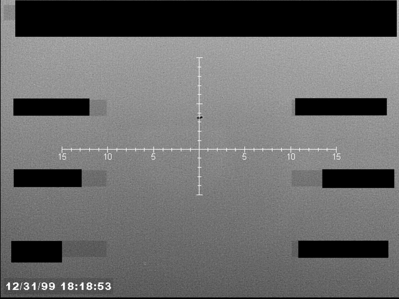
The page render shows the one-page released still-image PDF: a noisy monochrome sensor-style frame with a central reticle, top and side redactions, and the visible 12/31/99 18:18:53 overlay. The official release description says that image date is incorrect because the system date/time was not set.
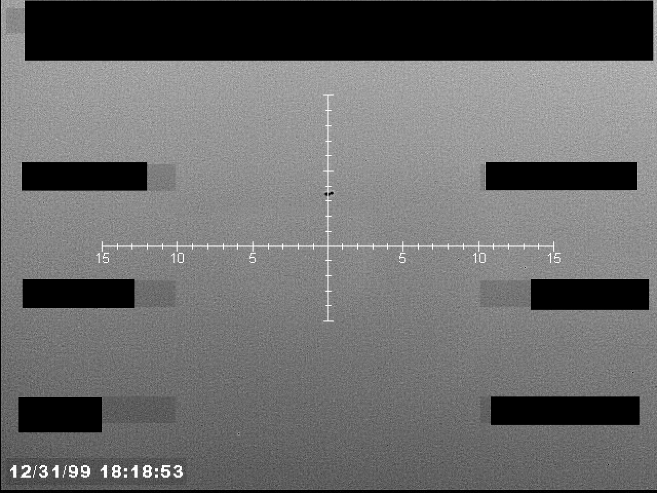
The embedded raster is the actual 1280 x 960 image object inside the PDF. It shows a compact, irregular dark pixel cluster close to the reticle center; the released still alone does not identify it or provide motion, range, platform, or collection geometry.
Investigation reading
FBI Photo B19 is a one-page Release 01 PDF containing a redacted still image. The Release 01 description identifies the submitting agency as FBI and says the item was a still image derived from a U.S. military system in 2025, submitted to AARO after redactions had already been applied. The same description says no accompanying mission report was provided and that the operator reported being unable to positively identify the UAP.
The file was reviewed as a PDF container, as its embedded raster image, as a rendered page image, against the available OCR text, and against the graph context for the release record and PDF asset. The Open Sky release-file copy verifies as 600,310 bytes with SHA-256 29dc410fc55141b34ee1a7bc42f41a1fa388ccba7086a3dba5774aaec27cf8b0. PDF inspection shows one encrypted/copy-restricted page, page size 640 x 480 points, PDF metadata title/subject B19 FBI Photo, and one embedded RGB image measuring 1280 x 960 pixels. The selectable text layer is effectively empty; the OCR pass captures only the visible timestamp: 12/31/99 18:18:53.
The displayed timestamp should not be treated as the incident time. The visible lower-left overlay reads 12/31/99 18:18:53, and the official release description says the image date is incorrect because the system date/time was not set. The broader release-record context currently available here is Late 2025 and Western United States. The public file does not expose exact collection date, platform, sensor model, range, altitude, field of view, location, mission track, or frame-sequence context.
What the file appears to contain
The rendered page and extracted image show a noisy monochrome sensor-style frame with a central white reticle. The horizontal reticle line is labeled outward from center with 5, 10, and 15 markings on both sides; the vertical line has tick marks but no clear numeric labels. A large black redaction band covers much of the top of the frame, and smaller black redaction blocks cover left and right display regions. These blocks obscure display fields or source annotations and should be kept separate from the original scene content.
The visible scene is mostly a mottled gray background. There is no clear horizon, terrain, waterline, building, vehicle, person, aircraft silhouette, star field, cloud form, or landmark in the public still. The feature of interest is a very small, dark, irregular pixel cluster near the center of the reticle, slightly above the horizontal line and close to the vertical centerline. It is too small and low-resolution in this release copy to determine shape, structure, scale, distance, motion, or identity. The official narrative describes a small cluster of dark pixels at the exact center of the reticle; the rendered image supports only the narrower statement that a compact unresolved dark feature is visible near the reticle center.
The released still alone does not establish whether the feature is an external object, image artifact, sensor/display artifact, redaction/processing artifact, or something else. No adjacent frames, video sequence, raw telemetry, mission report, operator log, or unredacted display fields are included in this PDF.
Source custody and provenance
- Official/source URL: https://www.war.gov/medialink/ufo/release_1/fbi-photo-b19.pdf
- Open released file: war-gov-fbi-photo-b19-eda0a3d3
- Release 01 row currently associated with this page:
122 - Agency:
FBI - Source/container kind: one-page PDF still-image container
- Verified Open Sky release-file size:
600,310bytes - Verified Open Sky release-file SHA-256:
29dc410fc55141b34ee1a7bc42f41a1fa388ccba7086a3dba5774aaec27cf8b0 - Embedded image: one RGB image,
1280 x 960pixels - Release-record incident context:
Late 2025,Western United States
A direct HEAD request to the official media URL returned 403, while a browser-like ranged retrieval returned a current 125,697-byte PDF with SHA-256 43fc008a99501f57a114be1246ba3cae6004b734d2609c2f7eb6611b9209e509. That current official-server copy has the same title, one-page structure, 1280 x 960 embedded image, visible timestamp, reticle layout, redaction pattern, and central unresolved dark feature. Treat the size/hash difference as a custody/versioning lead unless a source-side change log or full binary comparison explains it as optimization or recompression.
Graph context
The graph has exact source records for the B19 PDF asset and for the Release 01 record with the same title. The selected release record associates this page with row 122, FBI, Late 2025, Western United States, redaction marked true, and the official PDF URL. The PDF asset record carries the same canonical URL and the verified Open Sky release-file SHA-256. The semantic layer currently carries 22 extracted claim records, 14 entity mentions, 4 sensor-event records, and no table rows for this asset.
The strongest source-backed points are narrow: the release describes a still image from a U.S. military system; the image was redacted before submission to AARO; no mission report accompanied it; the operator reportedly could not positively identify the UAP; and the visible image clock is unreliable. The sensor-event records are navigation cues triggered by phrases such as still image and military system. They are not four independent sensor tracks and do not represent released radar, telemetry, range, altitude, or multi-sensor corroboration.
Related graph records point to nearby FBI B-series photo items, including B16 and B21, but those links are release-neighborhood context unless each related item is checked by row number, URL, hash, and visible image content. One separate release-description record for this title surfaces row 125, while the selected release record and release metadata associate B19 with row 122; treat that as a release-index provenance cleanup lead, not a content conclusion about the image.
Leads to check
- Locate any less-redacted source frame, original image export, adjacent frames, video sequence, operator log, mission report, or AARO submission metadata.
- Verify the actual collection date/time outside the invalid
12/31/99 18:18:53display clock and the broadLate 2025release field. - Identify the platform, sensor type, reticle meaning, field of view, range scale, altitude context, location, and whether redactions hide telemetry or classification markings.
- Reconcile the row
122/ row125release-description mismatch before using row numbers or related-record links for cross-page analysis. - Compare the current official-server PDF against the verified Open Sky release-file copy to determine whether the byte-size/hash difference is only recompression or a material file revision.
- Run ordinary image-quality and prosaic checks before escalation: sensor blemish, dust/debris, compression artifact, display artifact, redaction artifact, distant aircraft, bird, balloon, terrain contrast, weather, illumination, and line-of-sight.
Lead check notes
- Checked — The verified Open Sky release-file copy contains one embedded RGB image object (
1280 x 960) and no embedded attachments; the derived page render and extracted raster above come from that PDF. - Blocked — Less-redacted source imagery, adjacent frames or video, original export, operator log, mission report, and AARO submission metadata are not present in the public PDF or release record checked here.
- Partial — The visible
12/31/99 18:18:53overlay is present in the PDF/OCR, but the official release says the image date is incorrect because the system clock was not set; the collection window remains onlyLate 2025in the release record. - Partial — Open Sky source records and release metadata associate B19 with row
122; a separate release-description record surfaced row125, so row numbering should remain a provenance-cleanup lead before cross-page comparison. - Partial — A browser-like ranged retrieval from the current official server returned a smaller PDF with the same visible title/page structure, embedded-image dimensions, timestamp, reticle/redaction layout, and central unresolved feature; the size/hash difference remains a custody/versioning lead until official change history or a full-source comparison resolves it.
- Checked — Rendered-page and embedded-raster review confirm a compact dark feature close to the reticle center. The public still does not support shape, distance, motion, identity, or object/source-cause determination.
- Needs external source — Sensor blemish, dust/debris, compression/display/redaction artifact, distant aircraft, bird, balloon, terrain, weather, illumination, and line-of-sight checks require unredacted imagery, source metadata, adjacent frames, exact location/time, or environmental data.
Deep investigation — graph + web reconnaissance
Source reread and media check
The source remains a one-page, copy-restricted PDF still-image container. The verified Open Sky release-file copy is 600,310 bytes with SHA-256 29dc410fc55141b34ee1a7bc42f41a1fa388ccba7086a3dba5774aaec27cf8b0; PDF inspection shows title/subject B19 FBI Photo, page size 640 x 480 points, and one RGB embedded image at 1280 x 960 pixels. The text/OCR layer contributes only the page marker and the visible lower-left timestamp 12/31/99 18:18:53, which the official release description already flags as an incorrect system-clock value.
Rendered-page and embedded-raster review show the same narrow evidence profile: a grainy monochrome frame, a central white crosshair reticle with 5/10/15 scale marks, a wide black redaction band across the top, smaller side redactions, and no resolved horizon, terrain, aircraft silhouette, vehicle, star field, or landmark. The compact dark feature is visible very close to the central vertical reticle line and slightly above the horizontal reticle axis. Because it is only a tiny irregular pixel cluster in a noisy, redacted single frame, this check keeps it as an unresolved image feature rather than treating the release-description phrase forming an object as an identification.
Graph connections and provenance drift
Read-only graph review found the exact PDF asset, the WAR.GOV/PURSUE Release 01 source node, three text chunks for the asset/manifest/OCR text, and a secondary UFO-USA Markdown conversion marked as derived from the official asset. The asset-level semantic layer currently has 22 machine-extracted claims, 14 entity mentions, and 4 sensor-event records. The useful source-backed anchors are narrow: FBI, AARO, a still image, a U.S. military system in 2025, broad Western United States context, pre-submission redaction, no accompanying mission report, an operator statement of inability to positively identify the UAP, and the invalid displayed date. The graph SensorEvent records are unreviewed machine cues from still image and military system; they are not four independent sensor tracks and do not add radar, range, altitude, telemetry, or multi-sensor corroboration.
The graph also preserves a row-mapping cleanup issue. The exact asset URL/hash identifies B19, but one current row-122 B19 release-record node still carries a stale final_url/hash profile pointing at fbi-photo-b16.pdf, while a row-125 B21 record carries the B19 final URL/body hash and the separate manifest-description chunk references row 125 for this B19 asset. Until the official CSV snapshot and graph reconciliation are pinned row-by-row, row 122/125 and neighboring B-series links should be used as provenance/navigation leads only, not as evidence that B19 and adjacent photos are the same event or the same object.
Official/archive reconnaissance
Direct WAR.GOV/PURSUE probes for the B19 PDF, the Release 01 landing page, and both observed CSV URL patterns returned 403 Forbidden during this check. That is an access/custody limitation, not a source-failure blocker, because the archived Open Sky release-file copy verifies by size/hash and the Wayback availability API reports an exact official-URL snapshot at 20260515085909. Fetching that archived exact-URL snapshot returned a one-page application/pdf copy of 125,697 bytes with SHA-256 43fc008a99501f57a114be1246ba3cae6004b734d2609c2f7eb6611b9209e509; it retains title/subject B19 FBI Photo, the same one-page structure, and a 1280 x 960 embedded image. Treat the 600,310-byte Open Sky copy versus 125,697-byte archived/current-server copy as a versioning or recompression lead until a file-level image comparison or official change history resolves it.
DVIDS search returned an empty 202 response, and Defense.gov/AARO search probes returned 403 from this environment. The release record itself has blank DVIDS/video pairing fields, so there is no usable public paired video or mission report for B19 at this stage. Secondary conversions remain discovery aids only; the official WAR.GOV/PURSUE file pointer and verified release-file bytes are the source of record.
Prosaic checks, limits, and next leads
Meaningful astronomy, weather, launch, satellite, aircraft, drone, balloon, or line-of-sight correlation is blocked by missing basics: exact date/time, precise location, platform, sensor model, field of view, range scale, pointing angle, altitude, adjacent frames, and any unredacted mission context. The first prosaic lane is therefore image-chain review: sensor blemish or hot/dead pixel behavior, display/crosshair overlay artifacts, compression/recompression, redaction or conversion artifacts, dust/debris near optics, terrain or cloud contrast, and distant aircraft/bird/balloon possibilities. None can be accepted or excluded from this single public still.
Follow-up should prioritize the less-redacted original frame, adjacent frames or video, the original image export and metadata, operator log, mission report, AARO submission package, and exact official CSV row snapshot. A file-level comparison between the 600,310-byte release copy and the 125,697-byte archived exact-URL copy should check whether the embedded image pixels are materially identical or only recompressed.
Limits
This page does not identify the central dark feature and does not assert a finding. The public file is a single redacted still-image PDF, not a full event package. There is no released motion sequence, no platform identity, no confirmed incident timestamp from the visible clock, no raw sensor data, no range or altitude measurement, no weather or astronomy context, and no independent corroborating source in the file. The visible mark is documented only as an unresolved feature in a noisy, redacted image pending review and additional source material.
Sources
- WAR.GOV / PURSUE Release 01 official PDF: FBI Photo B19
- Open Sky release-file endpoint for the same PDF: war-gov-fbi-photo-b19-eda0a3d3
- Release 01 record metadata used for this page: row
122, FBI, late 2025, Western United States - Verified file hash:
29dc410fc55141b34ee1a7bc42f41a1fa388ccba7086a3dba5774aaec27cf8b0 - Source-file review: one-page PDF inspection, embedded-image extraction, rendered-page visual check, direct OCR text check, current official ranged-file check, and graph-context review