DOW-UAP-D18, Mission Report, Iraq, December 2022
Evidence media
- Official PDF: Open Sky release-file copy for the six-page D18 mission report.
- Paired video record: DOW-UAP-PR23 release-file copy and DVIDS source page. The release metadata describes this as a ten-second infrared clip paired with the D18 report; frame-level review belongs on the PR23 video page.
Derived page renders from the official PDF:
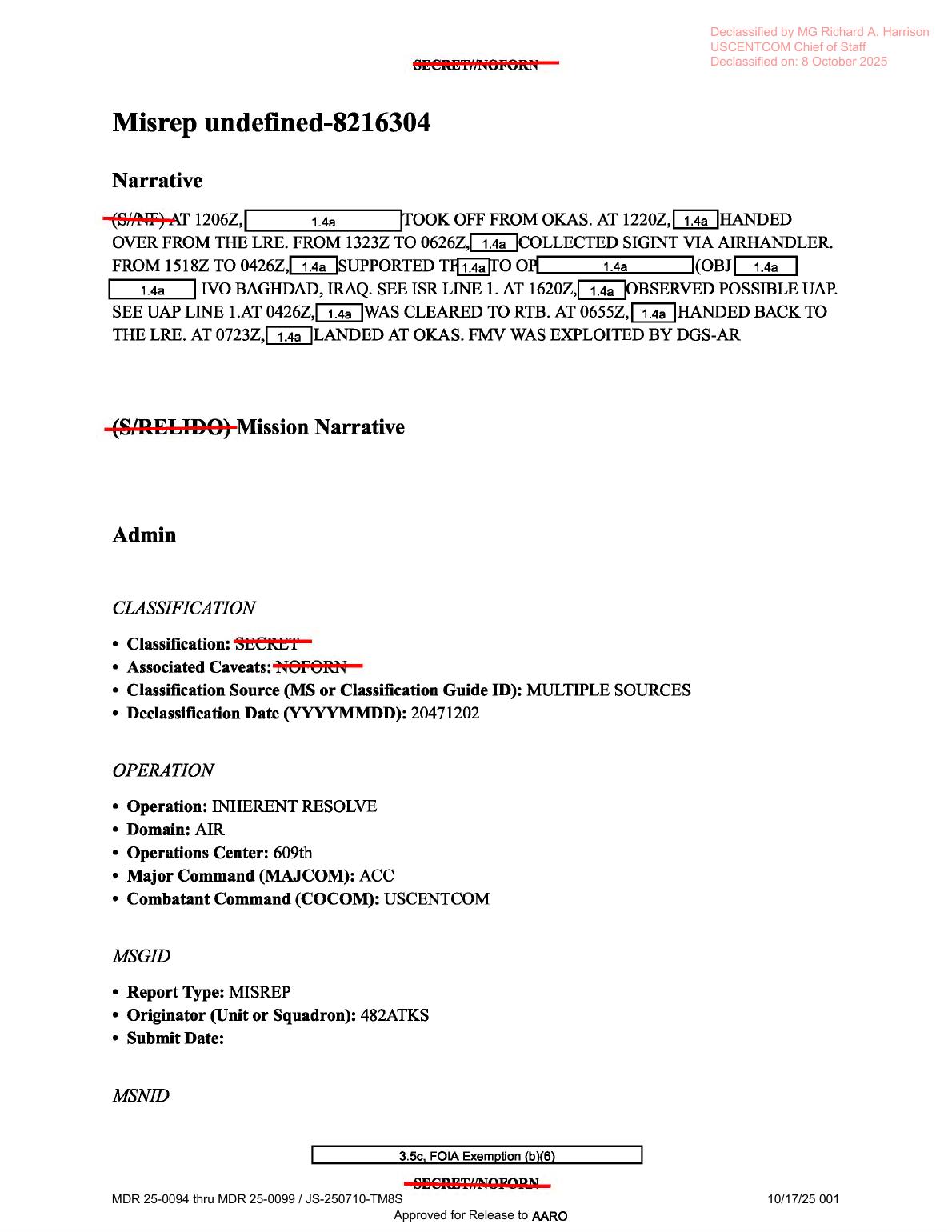
Page 1 is the mission narrative page. It is useful here because the page image/text layer supports the corrected timing sequence: 1220Z LRE handover, 1323Z to 0626Z SIGINT collection, 1620Z possible UAP, SEE UAP LINE 1, 0426Z RTB, and 0655Z handback.
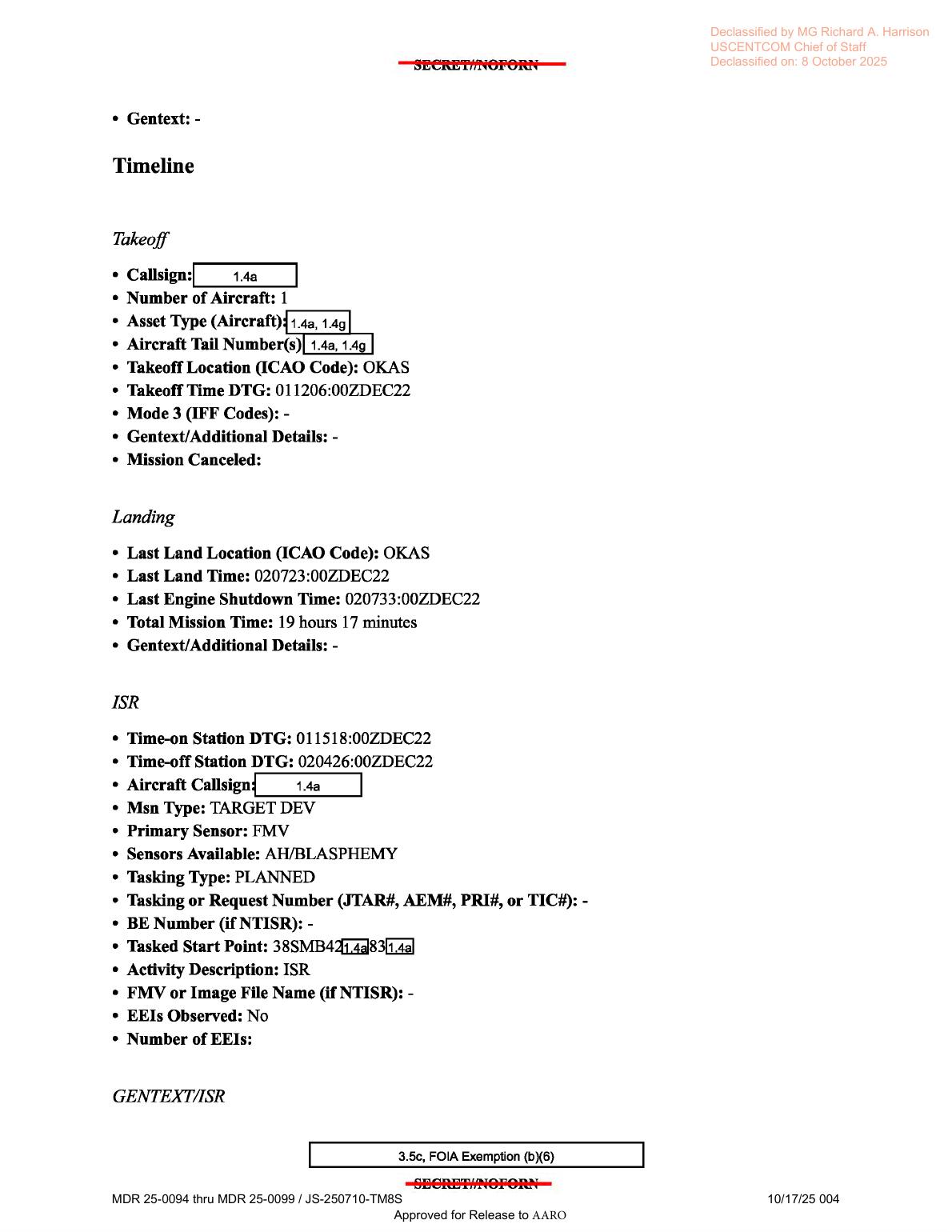
Page 4 is the timeline/ISR form page, including takeoff/landing times, the 011518:00ZDEC22 to 020426:00ZDEC22 ISR window, primary sensor FMV, and sensors available AH/BLASPHEMY.
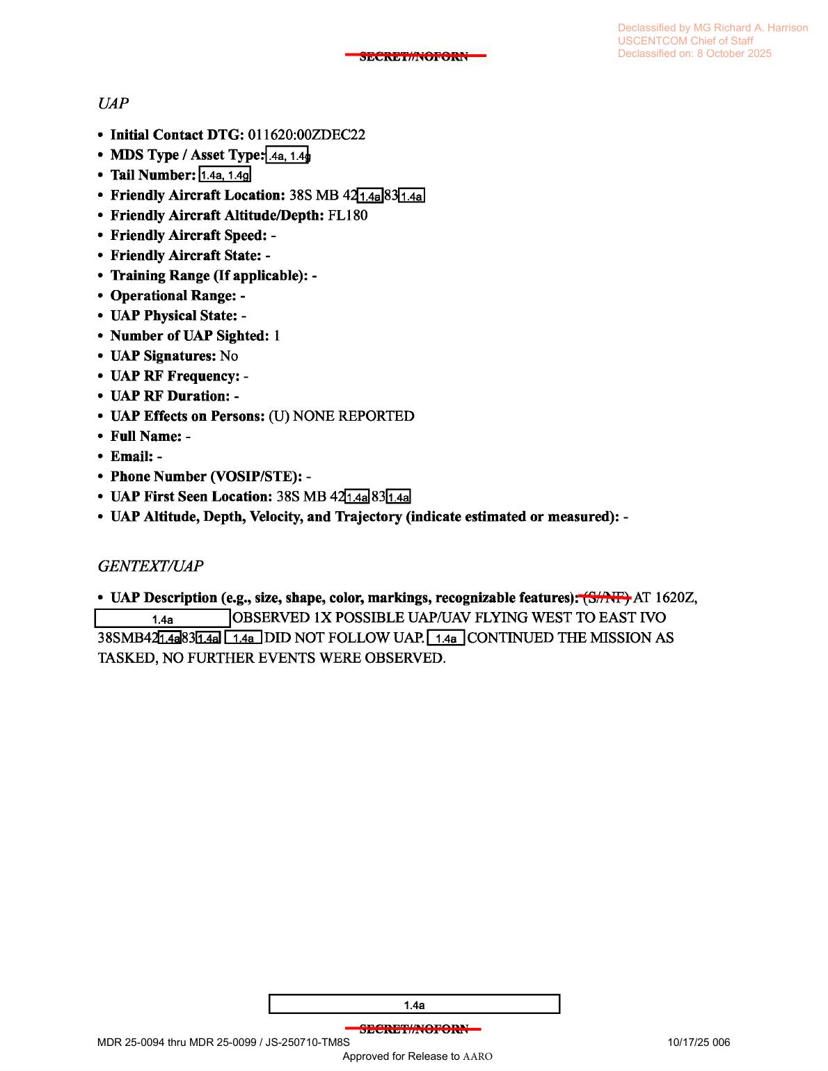
Page 6 is the UAP form page. It records 011620:00ZDEC22, one possible UAP/UAV, movement west to east, UAP Signatures: No, dash entries for RF frequency/duration, and no populated object altitude/velocity/trajectory field.
Investigation reading
This file is a six-page MISREP-style mission report for a U.S. military ISR mission over Iraq in December 2022. It is not itself the infrared video. The release metadata pairs it with DOW-UAP-PR23, a separate video record, so this page should be read as the accompanying mission-report context for that media item rather than as a visual analysis of the video.
The narrow high-signal content is on the UAP page and in the opening narrative. The form records an initial contact time of 011620:00ZDEC22, one possible UAP/UAV, and a general movement description of west to east near a partly redacted MGRS-style location beginning 38S MB 42…83…. The same UAP page says the reporting platform did not follow the object, that no further events were observed, that UAP Signatures were marked No, RF frequency/duration fields were blank/dash entries, and effects on persons were marked none reported.
A rendered-page check matters here because the OCR/text extraction has several timing errors on page 1. The rendered page reads 1220Z handover from LRE, 1323Z to 0626Z SIGINT collection, 1620Z possible UAP, SEE UAP LINE 1, 0426Z cleared to RTB, and 0655Z handback to LRE. Those values align with the structured UAP page better than the noisier OCR line that misread some of those fields.
What the file appears to contain
The PDF is a text-only form packet. Rendering all six pages shows no embedded object photograph, no map, no diagram, no sensor frame, and no still image from the paired video.
| Page | Contents read from the source |
|---|---|
| 1 | MISREP narrative and admin fields. It describes takeoff from OKAS at 1206Z, LRE handover at 1220Z, SIGINT via AIRHANDLER from 1323Z to 0626Z, ISR support in the vicinity of Baghdad, Iraq from 1518Z to 0426Z, a possible UAP observation at 1620Z, RTB clearance at 0426Z, LRE handback at 0655Z, landing at OKAS at 0723Z, and FMV exploited by DGS-AR. |
| 2 | Tasking, POC, QC, approver, and ingest/contact fields. Visible values include ISR mission type, U.S. Air Force tasking, units such as 482ATKS, 20 FW, 12 AF PAROC, 609 AOC, and 609 CAOC, with personal details redacted. |
| 3 | Aircraft/equipment form fields. The aircraft callsign is redacted. Radar, radar software, RWR, MWS, IRCM, ECM, chaff, flare, decoy, missile, gun, and data-link fields are mostly dash entries or blank prompts. A redaction appears near an air-to-ground weapons line, but no visible radar/RF/IR measurement data is provided on this page. |
| 4 | Timeline and ISR fields. It lists one aircraft, takeoff and landing at OKAS, total mission time 19 hours 17 minutes, ISR time-on station 011518:00ZDEC22 and time-off station 020426:00ZDEC22, mission type TARGET DEV, primary sensor FMV, sensors available AH/BLASPHEMY, tasked start point beginning 38SMB42…83…, activity description ISR, and EEIs Observed: No. |
| 5 | GENTEXT/ISR, ISR asset utilization, weather, effectiveness, and on/off-station fields. It records precoordination 236 minutes before takeoff, satisfactory precoordination, on-station arrival at 011220:00ZDEC22, scans for HVI/POI, POL, ADMS in suits, weapons, convoy/sentry, and personnel, weather was not a factor, Intel Gap Filled?: No, and off-station time 020655:00ZDEC22. |
| 6 | UAP form page. It records initial contact 011620:00ZDEC22, a redacted platform/asset and tail number, friendly aircraft altitude FL180, number of UAP sighted 1, UAP Signatures: No, RF fields as dash entries, UAP Effects on Persons: (U) NONE REPORTED, a first-seen location beginning 38S MB 42…83…, no populated altitude/depth/velocity/trajectory field, and a GENTEXT description: one possible UAP/UAV flying west to east; the platform did not follow it; no further events were observed. |
Source custody and provenance
- Publisher / agency: Department of War, PURSUE Release 01.
- Official PDF URL: https://www.war.gov/medialink/ufo/release_1/dow-uap-d18-mission-report-iraq-december-2022.pdf
- Open Sky release-file copy: war-gov-dow-uap-d18-mission-report-iraq-december-2022-9961adf6
- SHA-256:
4752dd830144b21c3055a2fea8b44c551445b41622c27db64fb0fa07c2dcd93d - File size / type: 3,673,697-byte PDF, 6 pages.
- Release rows: CSV row
39for the D18 mission report and row80for the paired PR23 video record. - Release record context: row 39 lists incident date
12/1/22, incident locationIraq, redactionTRUE, and DVIDS video ID1006062for the paired PR23 media item.
The document footer indicates approval for release to AARO and carries control text MDR 25-0094 thru MDR 25-0099 / JS-250710-TM8S. The page headers state declassification by MG Richard A. Harrison, USCENTCOM Chief of Staff, on 8 October 2025.
Graph context
Open Sky currently models this item as both an official release record and an official PDF asset. The graph also connects it to DOW-UAP-PR23, Unresolved UAP Report, Iraq, December 2022, represented as related video evidence from DVIDS video 1006062.
The semantic graph has 99 extracted claim records, 72 entity mentions, and 5 sensor-event records for this PDF, with no candidate crosslinks currently attached. Those counts are useful as navigation cues, not as findings. The extracted sensor events need careful reading because the source contains many form prompts. Page 3 visibly lists radar, RWR, MWS, IRCM, ECM, chaff, flare, missile, and gun fields, but most of those are dash entries rather than populated instrument records. The source-backed sensor/media terms for this PDF are primarily FMV, AIRHANDLER/SIGINT in the mission narrative, and the paired-video context; the PDF does not include raw radar plots, RF captures, or video frames.
The graph also preserves both manifest language and OCR/text-layer language. For this item, rendered-page review shows that some OCR-derived page-1 times and labels need correction before downstream analytics rely on them: the UAP time is 1620Z, not the noisier extracted 1639Z, and the page points to UAP line 1, not a map line.
Leads to check
- Review the paired DOW-UAP-PR23 video as a separate source and compare its visible motion, timestamp behavior, sensor field of view, and DVIDS metadata against the D18 text line that describes movement from west to east.
- Reconcile page-1 OCR discrepancies in the graph/text layer: 1220Z, 0626Z, 1620Z, SEE UAP LINE 1, 0426Z RTB, and 0655Z should be checked against the rendered PDF before being used in timelines.
- Compare the redacted MGRS-style fragments beginning
38S MB 42…83…with any lawful released metadata from the paired video or other Release 01 records; do not infer a precise location from the partial string alone. - Separate equipment form prompts from actual sensor evidence. Radar/RWR/IRCM/ECM terms appear in empty or dash-filled fields and should not be counted as radar/RF corroboration without populated data.
- Run normal prosaic-context checks after video review: platform motion, sensor mode, range/geometry, weather and illumination, other aircraft or UAV activity, and mission context around Baghdad on 1 December 2022.
Lead check notes
- Partial — paired PR23 video: Release metadata and the verified PR23 MP4 record connect the D18 PDF to DVIDS video
1006062; the manifest describes a ten-second infrared clip with an area of contrast moving from the lower-left toward the upper-right of the sensor view. That confirms a source-backed pairing, but the video still needs a separate frame/timestamp review before comparing apparent motion against the D18 west-to-east text line. - Checked — page-1 OCR/timing discrepancies: The PDF text layer and rendered page 1 support
1220Z,1323Zto0626Z,1620Z,SEE UAP LINE 1,0426Z, and0655Z. The stored OCR line that reads1232Z,0432Z,1639Z,SEE MAP LINE L,0042Z, and0055Zshould remain a text-extraction quality-control issue, not a source timeline. - Blocked — redacted MGRS/location fragments: Pages 4 and 6 preserve only partial/redacted location strings around
38SMB4…83…/38S MB 4…83…. The public PDF does not provide an unredacted coordinate, so precise geolocation requires another lawful source such as unredacted mission metadata, authoritative video metadata, or an official follow-on release. - Checked — equipment prompts vs populated sensor evidence: Page 3 lists radar, RWR, MWS, IRCM, ECM, chaff, flare, missile, gun, and data-link fields as blanks or dash entries. The populated source-backed media/sensor context in this PDF is FMV exploitation, AIRHANDLER/SIGINT mission context, and the paired PR23 video record—not raw radar/RF corroboration.
- Needs external source — prosaic context: Page 5 says weather was not a factor, but the PDF does not supply raw weather observations, exact coordinates, platform/sensor geometry, range, illumination, or traffic/UAV deconfliction. Those checks require the PR23 video plus external weather/astronomy/air-traffic or mission-context sources.
Limits
This draft does not resolve the case. The PDF reports a possible UAP/UAV observation, but it does not provide object imagery, a map, a radar plot, RF data, a measured speed, a populated altitude/trajectory field for the object, or independent witness statements. Redactions obscure the platform, tail number, portions of the location, and operational details. The statement that weather was not a factor is a form entry inside the mission report, not an independent weather reconstruction. The paired PR23 video must be reviewed before drawing any source-level judgment about what the sensor actually shows.
Deep investigation — graph + web reconnaissance
Source reread
A fresh source reread of the six-page PDF and the rendered page images keeps this page centered on what the report actually says. Page 1 confirms the corrected sequence already noted above: takeoff from OKAS at 1206Z, LRE handover at 1220Z, SIGINT collection via AIRHANDLER from 1323Z to 0626Z, ISR support near Baghdad, Iraq from 1518Z to 0426Z, possible UAP observation at 1620Z, SEE UAP LINE 1, RTB at 0426Z, handback to LRE at 0655Z, landing at 0723Z, and FMV exploitation by DGS-AR. This visual check is important because the OCR layer still misreads several of those page-1 times and labels.
Page 6 is the narrow UAP source line: initial contact 011620:00ZDEC22, friendly aircraft altitude FL180, one possible UAP/UAV, UAP Signatures: No, dash entries for RF frequency/duration, no reported effects on persons, and a partly redacted MGRS-style fragment beginning 38S MB 42…83…. The object altitude/depth/velocity/trajectory field is not populated. The narrative says one possible UAP/UAV was seen flying west to east, was not followed, and that no further events were observed.
Graph connections reviewed
Read-only graph review confirmed the official D18 PDF asset node, the WAR.GOV release-record node, the paired DOW-UAP-PR23 DVIDS video node, and the secondary UFO-USA markdown-conversion node. The D18 asset node carries the official PDF URL, 3,673,697-byte size, SHA-256 4752dd830144b21c3055a2fea8b44c551445b41622c27db64fb0fa07c2dcd93d, 10 text chunks, 99 machine-extracted claim nodes, and 5 machine-extracted sensor-event nodes. Those graph objects are navigation and audit material; they are not findings.
The most useful confirmed graph connection is the D18/PR23 pairing. The PR23 video node points to DVIDS video 1006062 and the verified MP4 hash d6a177a7004837546b8e3ea12ad0e632d9c31eabca427e05ae6eb9d4e4493f47. The graph also exposes a row-number/provenance tension: D18/PR23 are tied to row 39 plus current row 80 in one graph path, while manifest wording also refers to row 83, and a row-83 record currently names DOW-UAP-PR28. Treat that as a release-row cleanup lead, not as an analytical cross-case connection.
The extracted sensor events need restraint. The source-backed sensor/media terms for D18 are FMV, AIRHANDLER/SIGINT mission context, and the separate PR23 infrared-style video exhibit. Some machine-extracted entries come from equipment-form prompts or blank/dash fields on page 3, so they should not be counted as radar, RF, missile-warning, or electronic-warfare corroboration unless a populated source field is found.
External provenance and context
Direct official WAR.GOV fetches for the PDF, release page, and CSV returned 403 Access Denied during this check, so the public page relies on the verified Open Sky release-file copy, cached release metadata, and graph-preserved official URLs for WAR.GOV custody. The paired DVIDS source page for DOW-UAP-PR23 was reachable and lists Video ID 1006062, VIRIN 221201-D-D0360-5883, date taken 12.01.2022, date posted 05.07.2026 23:30, location IQ, category B-Roll, length 00:00:10, and unit All Domain Anomaly Resolution Office.
DVIDS describes the PR23 exhibit as ten seconds of infrared-sensor footage from a U.S. military platform submitted by U.S. Central Command to AARO. It preserves the D18 wording that the UAP was described as “flying west to east,” while separately describing an “area of contrast” moving from the bottom-left to the top-right of the sensor field and leaving near the top-right corner at about six seconds. That is publisher description and should stay separated from any identification claim.
A representative review of the verified PR23 MP4 samples shows a grayscale/infrared-looking aerial view of a dense urban area with black masking/redaction blocks and cyan reticle/marker overlays. Around the six-second samples, a tiny unresolved contrast feature near the upper-right portion of the sensor view is broadly consistent with the DVIDS description, but the released MP4 is too compressed and context-poor to identify the feature or derive size, range, altitude, or speed.
Prosaic checks and blockers
Normal prosaic checks remain constrained. The PDF gives a date/time, Iraq/Baghdad-area context, and a partial/redacted grid fragment, but not enough unredacted location, sensor geometry, range, platform track, look angle, or raw telemetry to run precise weather, astronomy, satellite/reentry, air-traffic, drone, or ground-traffic correlations. Page 5 says weather was not a factor, but that is a report entry, not an independent weather reconstruction.
The strongest immediate prosaic lanes are therefore source-internal: platform motion and stabilization, parallax against the urban scene in PR23, ordinary UAV/aircraft or ground-traffic possibilities, thermal contrast against rooftops/roads, sensor display/compression artifacts, and the fact that the D18 source itself uses the combined term UAP/UAV. None of those lanes resolves the event from the released material alone.
Follow-up leads
- Reconcile release rows
39,80, and83against the current WAR.GOV CSV and graph records before using row numbers as stable citation anchors. - Compare the PR23 frame path against the D18 west-to-east statement only if platform orientation, sensor look angle, and georegistration are available; screen direction is not automatically world direction.
- Preserve the page-1 rendered-text corrections in downstream extraction cleanup:
1220Z,0626Z,1620Z,SEE UAP LINE 1,0426Z, and0655Z. - Seek any lawful telemetry-bearing or full-resolution source package before estimating size, speed, altitude, or trajectory.
Audit note
This section is a source-and-provenance deepening only. It does not create a finding, hypothesis, or resolution decision; machine-extracted graph claims remain needs_human_review/not_a_finding unless verified against the PDF or the paired video source.
Sources
- Department of War, PURSUE Release 01, DOW-UAP-D18, Mission Report, Iraq, December 2022: official PDF
- Open Sky release-file copy for D18: verified PDF
- Department of War Release 01 landing/CSV record context: WAR.GOV UFO release page
- Related paired media record, DOW-UAP-PR23, Unresolved UAP Report, Iraq, December 2022, DVIDS video
1006062: DVIDS page