DOW-UAP-D23, Mission Report, United Arab Emirates, October 2023
Evidence media
- Open Sky release-file copy: open the nine-page official PDF.
- Related official video: open the paired
DOW-UAP-PR26release-file video or the DVIDS source page. Release metadata describes PR26 as a 43-second infrared-sensor clip associated with D23; it should still be reviewed on its own page before assigning it to a specific UAP form line. - Related official video: open the paired
DOW-UAP-PR27release-file video or the DVIDS source page. Release metadata describes PR27 as a 4-minute-57-second infrared-sensor clip associated with D23; it should also be kept separate until frame/timestamp review is complete.
Derived page renders from the official PDF
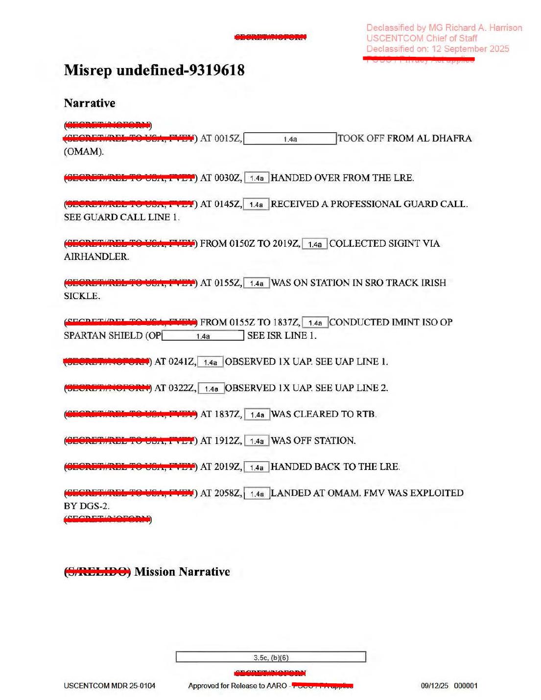
Page 1 is the mission narrative page. It records takeoff from Al Dhafra (OMAM), the professional guard call, SIGINT via AIRHANDLER, IMINT for OP SPARTAN SHIELD, UAP line 1 at 0241Z, UAP line 2 at 0322Z, landing at 2058Z, and FMV exploitation by DGS-2. It is text/form evidence, not a sensor frame.
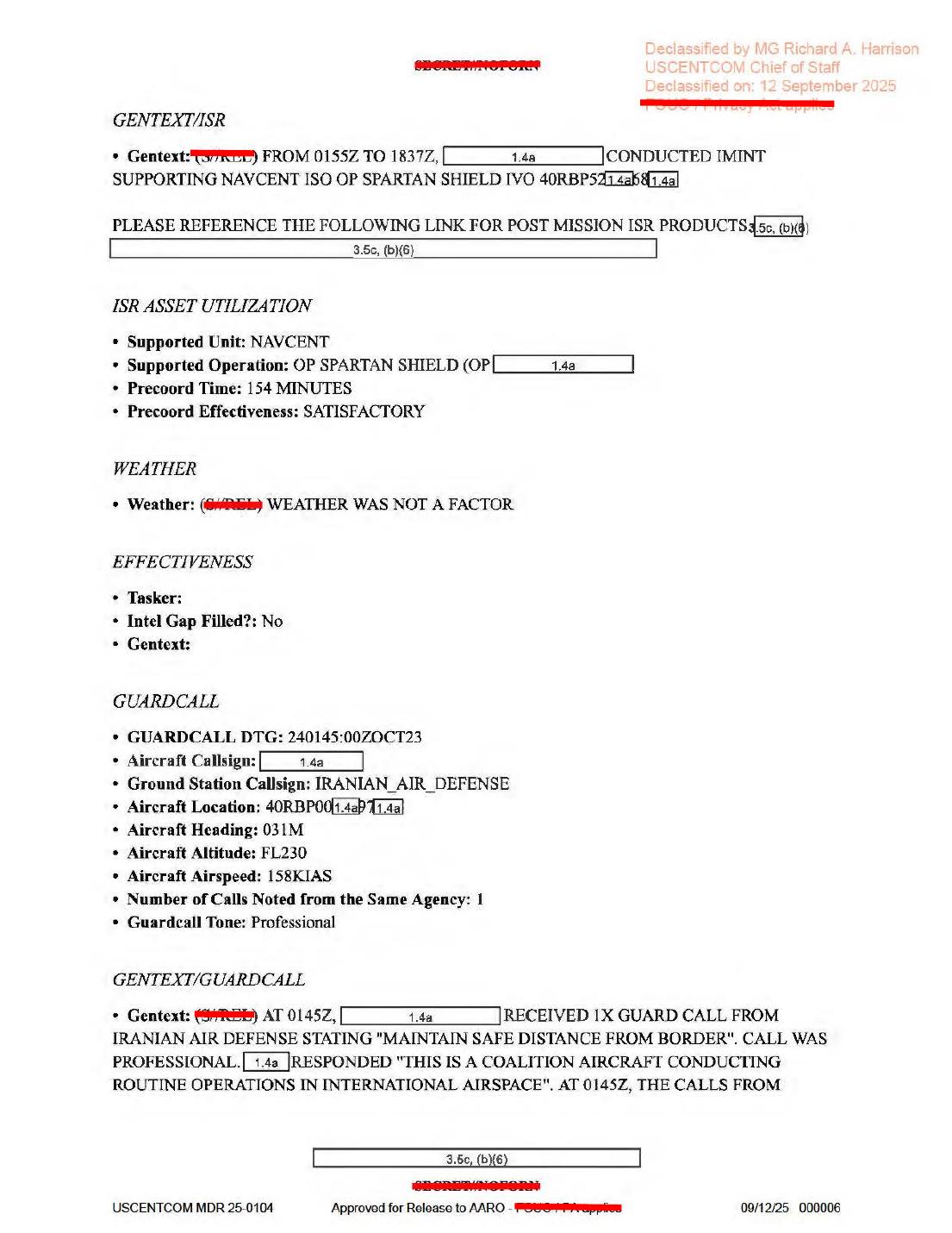
Page 6 preserves the ISR and guardcall context: IMINT supporting NAVCENT / OP SPARTAN SHIELD, Precoord Time: 154 MINUTES, weather marked as not a factor, and an IRANIAN_AIR_DEFENSE guard call telling the aircraft to “MAINTAIN SAFE DISTANCE FROM BORDER.” The page does not provide unredacted coordinates or raw weather data.
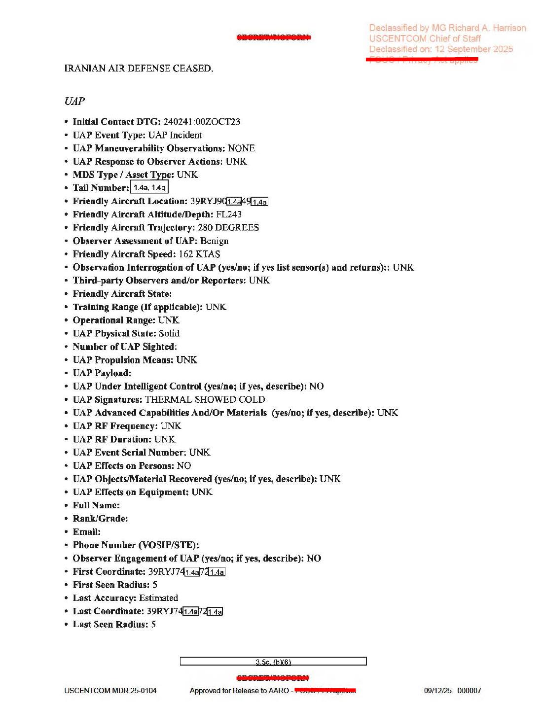
Page 7 is the first UAP form block. It lists initial contact 240241:00ZOCT23, friendly aircraft altitude FL243, trajectory 280 DEGREES, speed 162 KTAS, observer assessment Benign, physical state Solid, UAP Signatures: THERMAL SHOWED COLD, and redacted 39RYJ... coordinate fields.
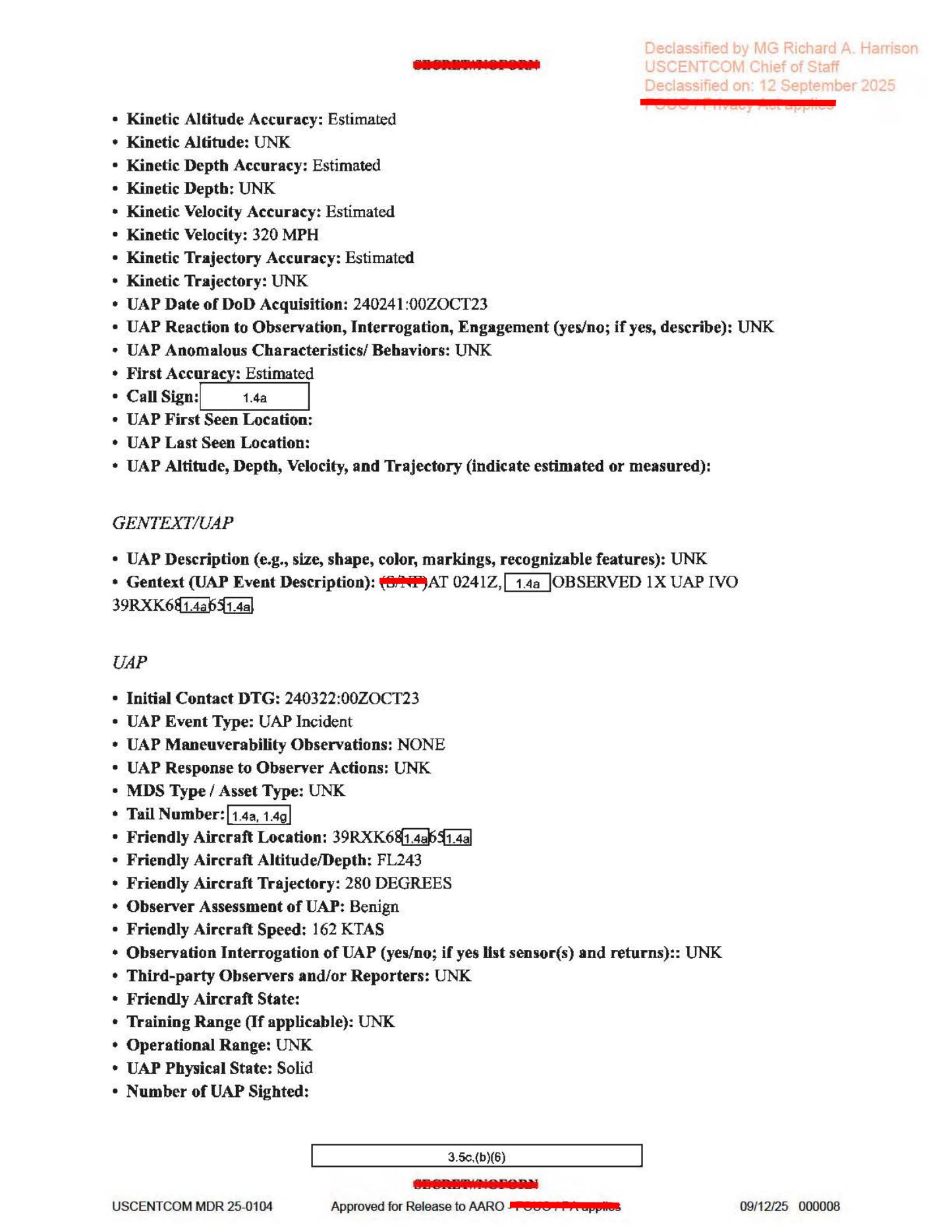
Page 8 continues the first UAP line with estimated kinetic velocity 320 MPH and the 0241Z gentext near a partially redacted 39RXK... grid reference. It also starts the second UAP form line at 240322:00ZOCT23, with the same friendly-aircraft altitude, trajectory, and speed pattern.
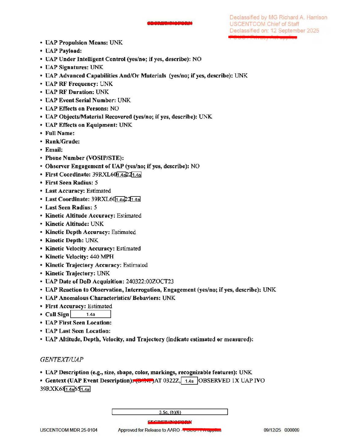
Page 9 continues the second UAP line. It lists UAP Signatures: UNK, no observer engagement, redacted coordinate fields, estimated kinetic velocity 440 MPH, and a gentext line saying that at 0322Z one UAP was observed near a partially redacted 39RXK... grid reference. Some timestamp and coordinate characters are OCR-sensitive, so the rendered page should be used for any exact transcription.
Investigation reading
This released file is a nine-page MISREP-style military mission report, not a photo packet or a video exhibit. The public PDF is a scanned form packet with redactions, declassification stamps, and typed fields. Visual page checks found no embedded object photograph, no sensor still, no radar plot, and no map inside the PDF itself. Its value is documentary: it preserves the mission timeline, a professional guard call, an ISR tasking window, and two UAP form entries that the release pairs with separate infrared-video records.
The mission narrative on page 1 says the aircraft took off from Al Dhafra (OMAM) at 0015Z, handed over from the LRE at 0030Z, received a professional guard call at 0145Z, collected SIGINT via AIRHANDLER from 0150Z to 2019Z, was on station in SRO track IRISH SICKLE, conducted IMINT in support of OP SPARTAN SHIELD, and then recorded two UAP observation lines: 0241Z and 0322Z. The page ends with the aircraft handing back to the LRE at 2019Z and landing at 2058Z. A rendered-page check is important here because stored OCR can misread that last landing time as 2035Z.
The two UAP entries are narrow form records. The first line starts at 240241:00Z OCT23; the second starts at 240322:00Z OCT23. Both entries list the event type as UAP Incident, maneuverability observations as NONE, observer assessment as Benign, friendly aircraft altitude as FL243, friendly aircraft trajectory as 280 DEGREES, friendly aircraft speed as 162 KTAS, and observation interrogation as UNK. The first line records UAP Signatures: THERMAL SHOWED COLD and estimated kinetic velocity 320 MPH. The second line records signatures as UNK and estimated kinetic velocity 440 MPH. Both entries leave many identifying, location, and object-description fields unknown, blank, or redacted.
The release manifest also links this PDF to DOW-UAP-PR26 and DOW-UAP-PR27 video records. Those descriptions say the paired media are infrared videos from a U.S. military platform: one 43-second clip with an area of contrast in the upper-left display region and one 4 minute 57 second clip where an area of contrast becomes distinguishable, is centered/zoomed by the sensor, and is later lost/reacquired as the sensor moves. Those videos should be read as separate evidence items; this PDF by itself does not show the video frames.
What the file appears to contain
| Page | Public read-through |
|---|---|
| 1 | Mission narrative. It records takeoff from OMAM, LRE handover, the 0145Z guard call, AIRHANDLER SIGINT, IMINT for OP SPARTAN SHIELD, UAP line 1 at 0241Z, UAP line 2 at 0322Z, return-to-base events, landing at 2058Z, and FMV WAS EXPLOITED BY DGS-2. |
| 2 | Administrative MISREP fields: classification/redaction fields, OP SPARTAN SHIELD, air domain, USCENTCOM, report type MISREP, originator 50ATKS, mission type ISR, country tasked US - UNITED STATES, service tasked AIR FORCE, and POC fields. |
| 3 | QC/approver/ingest fields and the beginning of ACEQUIP. The aircraft callsign is redacted and Radar Name or Destination is not populated. |
| 4 | Equipment prompt page. Most radar/RWR/MWS/IRCM/ECM/chaff/weapon fields are blank or dash-filled. Populated fields include Num Flares: 0, TGT Pod Name or Designator: ANDAS1, Additional Avionics: AHGMESH, Number of Aircraft: 1, takeoff location OMAM, and takeoff time 240015:00Z OCT23. |
| 5 | Landing/on-station/off-station fields. It gives last land location OMAM, last land time 242058:00Z OCT23, total mission time 20 hours 43 minutes, time on station 240155:00Z OCT23, time off station 241912:00Z OCT23, and total time on station 17 hours 17 minutes. |
| 6 | ISR and guardcall page. It says IMINT supported NAVCENT / OP SPARTAN SHIELD, gives Precoord Time: 154 MINUTES, says weather was not a factor, and records a professional call from IRANIAN_AIR_DEFENSE telling the aircraft to “MAINTAIN SAFE DISTANCE FROM BORDER.” The aircraft response is given as routine coalition operations in international airspace. |
| 7 | First UAP form block. Initial contact 240241:00Z OCT23; no maneuverability observed; response to observer actions unknown; friendly aircraft FL243, 280 DEGREES, 162 KTAS; observer assessment Benign; physical state Solid; THERMAL SHOWED COLD; effects on persons NO; observer engagement NO; first/last coordinates and some aircraft identifiers are partially redacted. |
| 8 | Continuation of UAP line 1 and start of UAP line 2. Line 1 has estimated kinetic velocity 320 MPH and a gentext entry saying that at 0241Z one UAP was observed in the vicinity of a partially redacted 39RXK... coordinate. Line 2 begins at 240322:00Z OCT23 with the same broad aircraft altitude/trajectory/speed pattern and Solid physical state. |
| 9 | Continuation of UAP line 2. It records signatures UNK, effects on persons NO, objects/material recovered UNK, effects on equipment UNK, observer engagement NO, partially redacted first/last coordinates, estimated kinetic velocity 440 MPH, UAP Date of DoD Acquisition: 240322:00Z OCT23, and gentext saying that at 0322Z one UAP was observed in the vicinity of a partially redacted 39RXK... coordinate. |
Source custody and provenance
- Official/source URL: DOW-UAP-D23 PDF
- Open Sky release-file copy: war-gov-dow-uap-d23-mission-report-united-arab-emirates-october-2023-d8e5687d
- SHA-256:
ea1cd5296143f378db533066b524c32c1ecfbfd43d74ec6be7d832c20fa271bb - File size:
1,324,277bytes. - PDF page count:
9. - PDF metadata identifies the title/subject as
DOW-UAP-D23, Mission Report, United Arab Emirates, October 2023; producer is Adobe Acrobat Paper Capture; creation date is September 12, 2025; modification date is May 7, 2026. - Release metadata associates this asset with CSV rows
42,81, and82; the broader manifest description also references rows42,43,84, and85because the D23 report is paired with PR26/PR27 video records. - OCR coverage is complete for this draft:
9 / 9pages have text. The PDF also contains scanned page images, one per page.
Graph context
The graph has an exact Document node for the PDF asset and an exact release-record node for the current-row entry. The PDF asset is modeled as war_pursue_pdf_asset with the same official URL and SHA-256 above. The release-record node points to the WAR.GOV Release 01 record and includes DVIDS context for the paired video material.
The semantic layer currently preserves 154 extracted source-text claim records, 119 entity mentions, 12 sensor-event records, 0 table rows, and text chunks from the OCR plus manifest description. Treat those as navigation aids, not conclusions. Several sensor-event entries are triggered by form prompts such as radar, RWR, IR-guided weapons, or equipment fields that are blank or dash-filled on the rendered page. The source-backed fields to carry forward from this PDF are more limited: FMV exploitation by DGS-2, AIRHANDLER SIGINT context, IMINT support for NAVCENT/OP SPARTAN SHIELD, a target-pod/avionics form entry, and the first UAP line’s THERMAL SHOWED COLD signature. The UAP form itself leaves observation interrogation as UNK and does not provide raw radar returns, raw IR frames, or plots inside the PDF.
Related graph records include DOW-UAP-PR26 and DOW-UAP-PR27, the paired United Arab Emirates video-report records. Their public descriptions should be inspected directly before tying a specific video frame to either the 0241Z or 0322Z form line. The graph also groups this record near other Release 01 mission/video entries, but no candidate crosslinks were present in the context reviewed for this page.
Leads to check
- Reconcile the manifest/CSV incident-date language with the report body. The release record lists an October 2023 incident date, while the visible MISREP DTGs repeatedly read as the 24th day of October 2023; the row context also includes
10/31/23. - Reconcile the manifest’s singular “one UAP” wording with the report body’s two UAP line entries at
0241Zand0322Z. They may be separate form lines, repeated observation of one object, or paired to separate media records; this draft does not decide that. - Review PR26 and PR27 as their own evidence pages before connecting the 43-second or 4:57 infrared clips to a specific form line.
- Preserve the rendered-page corrections as extraction-quality leads: page 1 reads landing at
2058Z, page 4 readsNumber of Aircraft: 1, page 6 readsPrecoord Time: 154 MINUTES, page 8 shows a39RXK...coordinate prefix for the0241Zgentext, and page 9 reads240322:00Z OCT23for the second UAP acquisition time. - Do not treat blank radar/RWR/weapon prompts as instrument evidence. The form prompts are useful context, but this PDF does not include radar tracks or sensor screenshots.
- The coordinates are partly redacted and vary by field (
39RYJ...,39RXK..., and39RXL...prefixes appear in different places). Any map or geolocation work needs a separate redaction-aware MGRS review.
Lead check notes
- Partial — Incident-date language: the PDF body repeatedly uses 24 October 2023 DTGs, including
240241:00ZOCT23,240322:00ZOCT23, and242058:00ZOCT23; the release-record context still carries10/31/23. The current release-file copy and linked video pages do not explain that mismatch, so treat it as release-metadata tension unless a corrected manifest or source record is found. - Partial — One-UAP wording versus two form lines: page 1 and the UAP form pages visibly preserve two report lines,
0241Zand0322Z, while the manifest prose says a military operator reported observing one UAP. The source supports the two form entries, but it does not yet show whether they are two observations of one object, two separate objects, or a duplicated reporting structure. - Partial — PR26/PR27 pairing: the linked PR26 page confirms DVIDS video
1006063, a 43-second infrared-sensor clip, CSV rows42/84, and MP4 SHA-25646fdeec860cdaa6b27b6fcc51d0b7e045347d494832cdc65f2038e702eaa58aa; the linked PR27 page confirms DVIDS video1006067, a 4-minute-57-second infrared-sensor clip, CSV rows43/85, and MP4 SHA-2563c510fe34677a0784c656105b9653ce3039d83de46f929f1ee6d6fb820ce3b8c. Both video files are available through Open Sky release-file routes, but frame-by-frame review remains a separate source task before assigning either video to the0241Zor0322Zline. - Checked — Rendered-page transcription checks: page 1 visibly supports landing at
2058Z; page 4 visibly supportsNumber of Aircraft: 1,TGT Pod Name or Designator: ANDAS1, andTakeoff Time DTG: 240015:00ZOCT23; page 6 visibly supportsPrecoord Time: 154 MINUTES; page 8 visibly supports39RXK...for the0241Zgentext and240322:00ZOCT23for the second UAP initial contact. Keep these as source-text quality notes, not analytical conclusions. - Blocked — Redacted MGRS/location work: the source pages show partial prefixes including
39RYJ...,39RXK...,39RXL..., and guardcall context beginning in the40RBP.../39RXX...area, but the released PDF withholds enough digits to prevent a precise public map point. Any geolocation check needs unredacted coordinates or an authoritative mission/source packet. - Checked — Blank sensor/equipment prompts: the report contains target-pod, SIGINT/AIRHANDLER, IMINT, FMV-exploitation, and thermal-signature text, but it does not include radar plots, raw IR frames, or screenshots inside the PDF. Blank or dashed radar/RWR/weapon prompt fields should stay as form context rather than instrument evidence.
Limits
This page is a graph investigation draft and is not a finding. The source is a redacted MISREP packet with many unknown or blank fields. It contains typed reporting fields, not original sensor imagery. The visual inspection here checked rendered PDF pages for text-bearing fields and for the absence of embedded media; it did not analyze the paired DVIDS video frames. The report’s own fields give estimated velocities and observer assessments, but do not provide enough unredacted location, raw measurement, sensor-return, or third-party-observer detail to resolve the event.
Deep investigation — graph + web reconnaissance
Source reread and rendered-page checks
The deep reread keeps this item anchored as a nine-page MISREP-style PDF, not as an image or video exhibit. The verified release-file copy is 1,324,277 bytes with SHA-256 ea1cd5296143f378db533066b524c32c1ecfbfd43d74ec6be7d832c20fa271bb; PDF metadata reports nine pages, Adobe Acrobat Paper Capture production, creation on September 12, 2025, and modification on May 7, 2026. Direct WAR.GOV PDF and CSV probes returned 403 Forbidden during this check, so the audit used the verified Open Sky release-file copy plus the already-ingested official WAR.GOV records.
Rendered-page review confirms the source timeline rather than resolving the event. Page 1 visibly reads takeoff from Al Dhafra / OMAM at 0015Z, LRE handover at 0030Z, a professional guard call at 0145Z, AIRHANDLER SIGINT from 0150Z to 2019Z, IMINT in support of OP SPARTAN SHIELD from 0155Z to 1837Z, UAP line references at 0241Z and 0322Z, off-station at 1912Z, handback to the LRE at 2019Z, landing at 2058Z, and FMV exploitation by DGS-2. Pages 7-9 preserve two UAP form entries: the first begins 240241:00Z OCT23 with friendly aircraft FL243, 280 DEGREES, 162 KTAS, assessment Benign, physical state Solid, and UAP Signatures: THERMAL SHOWED COLD; the second begins 240322:00Z OCT23, repeats the broad aircraft altitude/trajectory/speed pattern, lists signatures as UNK, and gives estimated kinetic velocity 440 MPH. The location strings are only partial MGRS-style prefixes (39RYJ..., 39RXK..., 39RXL...), with redaction boxes over the digits needed for a public coordinate.
Graph connections and provenance cleanup
Read-only graph checks found the exact official PDF asset, the exact current release-record row, and the OCR/text chunks used by the semantic layer. The official asset node is modeled as a WAR.GOV PDF asset with the same canonical URL, SHA-256, byte count, and nine-page OCR coverage. The current release-record row is row 42 and carries release metadata for 10/31/23, Arabian Gulf, and video pairing PR-26 | PR-27.
The semantic graph currently contains 154 unreviewed machine-extracted claim nodes, 14 text chunks, and 12 sensor-event nodes for this PDF. Those nodes are useful for navigation, but several sensor-event entries are extraction artifacts from form prompts or manifest video text. Source-backed sensor language in the PDF itself is narrower: FMV WAS EXPLOITED BY DGS-2, AIRHANDLER SIGINT, IMINT for NAVCENT / OP SPARTAN SHIELD, a target-pod form field (ANDAS1), and the first UAP line's cold thermal signature. The PDF does not include raw radar, raw infrared frames, plots, or a sensor track.
The graph also exposes a provenance-cleanup lead. The current asset relationship lists rows 42, 81, and 82 for D23, PR26, and PR27, while older manifest-description material and stale RELATED_TO edges still mention row 43 and rows 84/85 with current_in_official_csv: false. Treat the current row anchors (42, 81, 82) as the live Release 01 bookkeeping and the stale rows as graph-maintenance context, not evidence that D25, PR29, or PR31 are the same event.
External official-source checks
DVIDS video 1006067 for DOW-UAP-PR27 was reachable and matches the companion-video title. Its public description says the item is four minutes and 57 seconds of infrared-sensor footage from a U.S. military platform in 2023, paired with DoW-UAP-D23; it describes an area of contrast becoming distinguishable around 01:56, sensor centering at 02:04, a narrowed field of view at 02:14, and later loss/reacquisition as the sensor moves. The DVIDS page lists Date Taken: 10.01.2023, Date Posted: 05.07.2026 23:31, category B-Roll, and video ID 1006067.
DVIDS video 1006063 for DOW-UAP-PR26 was also reachable by title, date, category, and video ID, but the description text returned during this check appeared internally inconsistent: it described a 2022 still image, a red encircled area, and an accompanying DoW-UAP-D12 mission report rather than the expected D23/PR26 video-description text. That is a source-metadata anomaly to verify against DVIDS/WAR.GOV, not a source-backed reason to merge PR26 with D12 or to assign PR26 to either D23 line. The local PR26 and PR27 wiki pages should remain separate media records until an official timestamped crosswalk links each video interval to 0241Z, 0322Z, or a different reporting thread.
Prosaic checks and limits
The PDF provides enough to define the documentary question, but not enough to resolve it. It reports two UAP form entries, estimated velocities, a cold thermal signature for the first entry, and no observer engagement or effects on persons. It also records Weather was not a factor, but does not release raw weather, unredacted coordinates, range, field of view, azimuth/elevation, IR polarity, platform track, target track, or third-party observations. Without those fields, astronomy/weather/launch/satellite checks and object-speed calculations would be speculative.
The practical prosaic lanes remain sensor/platform motion, distant aircraft or airborne clutter, balloon/debris/bird/small-point sources, cloud or sea-background contrast, compression/gain/display artifacts, and release/metadata bookkeeping errors. The paired videos must be reviewed as their own source records before using their apparent motion as evidence for either UAP form line.
Follow-up leads
- Verify the PR26 DVIDS description anomaly against a later DVIDS page snapshot, WAR.GOV manifest copy, or official CSV revision before quoting PR26 descriptive text on this D23 page.
- Reconcile the source date language: D23 body fields use 24 October 2023 DTGs, while current release metadata carries
10/31/23and DVIDS pages showDate Taken: 10.01.2023. - Keep row-number cleanup separate from evidence interpretation: stale graph edges to rows
43,84, and85are provenance-maintenance leads, not event conclusions. - Do not geolocate the event from the partial
39R...coordinate prefixes unless an unredacted source packet or authoritative coordinate release appears.
Audit note
This section is a source-grounded audit note, not a finding. Machine-extracted graph claims remain unreviewed_machine_extract; the public evidence still supports an unresolved, redacted mission-report record with companion media leads, not a resolved identification or hypothesis.
Sources
- Department of War / WAR.GOV Release 01 PDF: DOW-UAP-D23, Mission Report, United Arab Emirates, October 2023
- Open Sky release-file endpoint for the verified PDF: /api/explore/war-gov/release-file/war-gov-dow-uap-d23-mission-report-united-arab-emirates-october-2023-d8e5687d
- Related video-record page: DOW-UAP-PR26, Unresolved UAP Report, United Arab Emirates, October 2023
- Related video-record page: DOW-UAP-PR27, Unresolved UAP Report, United Arab Emirates, October 2023