DOW-UAP-D8, Mission Report, Djibouti, 2025
Evidence media
- Official PDF: Open Sky release-file copy
- Derived page render: page 7, the only page with readable
GENTEXT/UAPcontent beyond redaction markings.
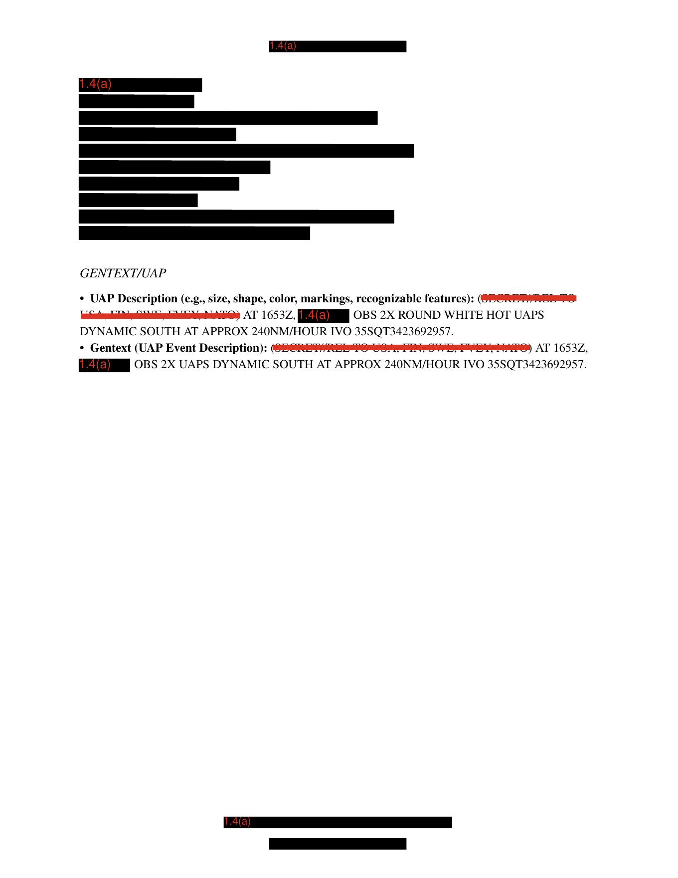
This is a derived render of page 7 from the official PDF. It shows redaction blocks and the two visible GENTEXT/UAP entries; it is not object imagery, a sensor frame, a radar plot, or a map.
Investigation reading
This is a short, heavily redacted seven-page MISREP-style PDF in PURSUE Release 01. I reviewed the complete released PDF, the stored OCR text, the selectable PDF text layer, and rendered images for all seven pages. Pages 1 through 6 are visually blacked out except for a red 1.4(a) marking; they do not expose substantive MISREP fields, imagery, tables, signatures, or narrative text. Page 7 is the only page with readable operational content beyond redaction markings.
The public title says DOW-UAP-D8, Mission Report, Djibouti, 2025. The release metadata does not provide a released incident date or location beyond the title, while the linked Release 01 record in the graph carries N/A for incident date and Mediterranean Sea as the incident location. That title/location mismatch is a custody lead, not a basis for resolving the event. This draft records the source text and graph context only; it does not identify the reported objects and does not assert a finding.
What the file appears to contain
The readable report content is concentrated in the GENTEXT/UAP section on page 7. The first visible bullet is the UAP-description field. Its text layer reads that at 1653Z, after a redacted 1.4(a) portion, an observer recorded 2X ROUND WHITE HOT UAPS moving or behaving DYNAMIC SOUTH at approximately 240NM/HOUR in the vicinity of 35SQT3423692957. The rendered page shows the classification/dissemination text around this field overprinted or partially struck through; the operational phrase after the redaction block is the clearest source-backed content.
The second visible bullet is the event-description field. It repeats the time 1653Z, a redacted 1.4(a) portion, and the statement OBS 2X UAPS DYNAMIC SOUTH AT APPROX 240NM/HOUR IVO 35SQT3423692957. Unlike the first bullet, this second field does not visibly repeat ROUND WHITE HOT; it preserves count, movement, speed estimate, and vicinity string.
| Page | Reading notes |
|---|---|
| 1 | Fully black/redacted rendered page with only 1.4(a) visible. No substantive MISREP content visible. |
| 2 | Fully black/redacted rendered page with only 1.4(a) visible. No substantive MISREP content visible. |
| 3 | Fully black/redacted rendered page with only 1.4(a) visible. No substantive MISREP content visible. |
| 4 | Fully black/redacted rendered page with only 1.4(a) visible. No substantive MISREP content visible. |
| 5 | Fully black/redacted rendered page with only 1.4(a) visible. No substantive MISREP content visible. |
| 6 | Fully black/redacted rendered page with only 1.4(a) visible. No substantive MISREP content visible. |
| 7 | Partly readable GENTEXT/UAP page with redaction blocks. It preserves 1653Z, 2X, ROUND WHITE HOT UAPS in the description field, DYNAMIC SOUTH, APPROX 240NM/HOUR, and IVO 35SQT3423692957. |
Taken at face value, the released file is therefore a narrow source record: two reported UAPs, described once as round and white-hot, moving south at an estimated 240 nautical miles per hour near an MGRS-like grid string. It does not release object imagery, raw sensor tracks, platform identity, environmental context, or a resolved explanation.
Source custody and provenance
- Official file title:
DOW-UAP-D8, Mission Report, Djibouti, 2025 - Agency: Department of War
- Release: PURSUE Release 01
- Release/CSV row:
75 - Official URL: https://www.war.gov/medialink/ufo/release_1/dow-uap-d8-mission-report-djibouti-2025.pdf
- Open Sky release-file route:
/api/explore/war-gov/release-file/war-gov-dow-uap-d8-mission-report-djibouti-2025-33cca996 - Verified source size:
29,154bytes - Verified SHA-256:
0a8548a845c3b45f90ee512bdfd8eac1af073072228e7e4d24e779d12025886c - PDF page count:
7 - OCR coverage:
7 / 7pages with text, though pages 1-6 only expose the redaction marker1.4(a)
The PDF metadata reports title/subject DOW-UAP-D8, Mission Report, Djibouti, 2025, a creation date of April 29, 2026, and a modification date of May 7, 2026. The document is a small, copy-restricted PDF with rendered redaction pages and a selectable text layer. The hash above matches the Release 01 metadata and the Open Sky release-file copy.
Graph context
The graph has two exact records for this item: a Release 01 record node and a linked PDF asset node. The PDF asset node carries the official/canonical URL and the verified SHA-256. The release record node carries the row-level Release 01 reference for row 75, redaction flag TRUE, incident date N/A, and incident location Mediterranean Sea.
Semantic extraction currently models 24 source-text claims, 21 entity mentions, 0 sensor events, and 0 table rows for this asset. Treat those counts as navigation and audit cues, not findings. The repeated claim groups are dominated by the manifest description and the two page-7 GENTEXT lines: observation language, witness/operator language, motion/speed language, the 1653Z time, document identity, agency references, and redaction limitations.
The graph also shows ordinary relationship context to the item’s own asset/record pair and nearby Release 01 material, including DOW-UAP-D7 and an unresolved-report record. There are no candidate crosslinks for this page in the current context output. Any regional, title, or sequence-based comparison should remain a lead until the related sources are reviewed independently.
Leads to check
- Reconcile the public title
Djibouti, 2025with the graph release record’sMediterranean Seaincident-location field andN/Aincident date. - Decode and plot
35SQT3423692957only after confirming the intended grid reference system and datum. Do not convert it into a precise event location without source validation. - Check whether any paired release record, image, video, mission report, or DVIDS item exists for this D8 event. This PDF itself does not release object imagery or raw sensor media.
- Separate the two GENTEXT fields during review: the description field preserves
ROUND WHITE HOT; the event-description field preserves count/motion/speed/location but does not visibly repeat shape or thermal appearance. - Validate the meaning of
DYNAMIC SOUTHin the source context before treating it as a precise heading, track, maneuver type, or wind-relative description. - Run prosaic/context checks only after custody and location are reconciled: aircraft/airspace activity, balloons or UAS, weather at the relevant time and location, sensor/platform geometry, and whether the
white hotdescriptor reflects thermal display settings rather than intrinsic object appearance.
Lead check notes
- Checked — The Open Sky release-file PDF verifies to SHA-256
0a8548a845c3b45f90ee512bdfd8eac1af073072228e7e4d24e779d12025886c,29,154bytes, and seven pages. The page-7 render and selectable text confirm that pages 1-6 expose only redaction markings and that page 7 is text/redaction content, not object imagery. - Partial — Release metadata preserves a title/location tension rather than resolving it: the official PDF and PDF metadata title say
Djibouti, 2025, while the exact Release 01 record for row75lists incident dateN/Aand incident locationMediterranean Sea. Corrected official manifest history or another authoritative source is still needed before changing the public location/date. - Partial — Exact anchor searches in the current linked Release 01 OCR corpus found
35SQT3423692957,ROUND WHITE HOT,DYNAMIC SOUTH, and240NM/HOURonly in this D8 OCR/PDF. The grid string should remain a coordinate-format lead until the intended grid system, datum, and unredacted operational context are confirmed. - Partial — The D8 PDF release row itself does not expose a DVIDS/video/still pairing, but the separate PR29 / DVIDS
1006074video record says its accompanying mission report wasDoW-UAP-D8. PR29's Gulf of Oman / United Arab Emirates / June 2024 video-description language does not match the visible D8 page-7 text, so PR29 remains a source-alignment lead and is not embedded here as confirmed D8 evidence. - Checked — The page render, OCR, and selectable text support separating the two
GENTEXT/UAPfields: the description field includesROUND WHITE HOT UAPS, while the event-description field repeats count, motion, speed, and grid wording without visibly repeating the shape/thermal phrase. - Needs external source —
DYNAMIC SOUTH, thewhite hotdisplay wording, sensor/platform geometry, exact location, flight tracks, weather, airspace, astronomy/space-object checks, and any paired media review remain unresolved without unredacted source material or a reconciled companion record.
Limits
This file is mostly redacted. Six of seven pages expose only 1.4(a). Page 7 omits the observer/platform identity, most surrounding form fields, any underlying track data, any source imagery, weather, altitude, range, duration, sensor mode, and follow-up analysis. The speed value is reported/estimated in the released text; the PDF does not provide enough context to evaluate measurement method or uncertainty.
The visible phrases are source-form entries, not a resolution. The graph’s extracted claims help locate repeated source text, but repeated manifest and OCR passages can inflate apparent claim volume. This page should remain a graph_investigation_draft with investigation_status: needs_human_review and finding_status: not_a_finding until a human reviewer checks the official row, any paired media, and external context.
Deep investigation — graph + web reconnaissance
Source reread
The deep reread rechecked the seven-page PDF against the OCR text, selectable text, and the derived page-7 render. Pages 1-6 remain effectively redacted, exposing only 1.4(a) markings. Page 7 preserves the only substantive released source text: two GENTEXT/UAP bullets interrupted by 1.4(a) redactions. A visual check of the rendered page confirms that the first bullet visibly includes OBS 2X ROUND WHITE HOT UAPS DYNAMIC SOUTH AT APPROX 240NM/HOUR IVO 35SQT3423692957; the second bullet repeats OBS 2X UAPS DYNAMIC SOUTH AT APPROX 240NM/HOUR IVO 35SQT3423692957 without visibly repeating ROUND WHITE HOT.
That means the defensible source facts are narrow: a redacted form entry at 1653Z, two reported objects, one description field saying ROUND WHITE HOT UAPS, southward/dynamic wording, an estimated 240NM/HOUR, and an MGRS-like vicinity string. The released PDF does not provide the observation platform, unredacted coordinates, altitude, range, duration, sensor mode, weather, object imagery, radar data, track files, or follow-up analysis.
Read-only graph connections
A read-only Neo4j check matched the exact official PDF asset by URL and SHA-256 and found the expected Release 01 source spine: official WAR.GOV/PURSUE source, row-level release record, PDF asset, OCR/source chunks, and semantic extraction. The current semantic layer for this asset contains 24 machine-extracted claims and 21 entity mentions, with 0 sensor-event nodes and 0 table rows. Those extracted claims preserve the same source-text anchors above, plus document identity, agency references, the 1653Z time, measurements, and redaction limitations. They remain machine_extracted_needs_human_review, not findings.
The graph search found no CANDIDATE_CROSSLINK relationship for this asset. Exact anchor searches for 35SQT3423692957, ROUND WHITE HOT, DYNAMIC SOUTH, and 240NM/HOUR currently point back to this D8 OCR/PDF rather than to a second independent Release 01 document. The graph does, however, expose a provenance/indexing cleanup lead: the D8 asset is correctly related to release row 75, while read-only URL matching also surfaces a separate PR21 row whose final_url currently points at the D8 PDF, and the row-75 record shows a mismatched final_url in graph metadata. Treat that as release-manifest/graph hygiene work, not as evidence that the cases are substantively connected.
Official web and paired-media reconnaissance
Direct WAR.GOV probes for the D8 PDF, the release landing page, and the official CSV returned 403 Forbidden during this run, so the verified Open Sky release-file copy remains the accessible public file path for this page. The official DVIDS page for video 1006074 was reachable and is titled DOW-UAP-PR29, Unresolved UAP Report, United Arab Emirates, June 2024; DVIDS lists Date Taken: 06.01.2024 and Date Posted: 05.08.2026.
That DVIDS description is relevant but not settled custody. It says the PR29 video is 21 seconds of infrared footage from a U.S. military platform, and says an accompanying mission report named DoW-UAP-D8 described an object with a vertical pole/bar below it and a possible reflection from an object in the water. Those phrases do not appear in the visible D8 page-7 text reviewed here. They more closely resemble another Release 01 mission-report thread already carrying its own title/date/location tensions. Until the official row/video/mission-report mapping is reconciled, PR29/DVIDS 1006074 should remain a paired-media alignment lead rather than confirmed D8 evidence.
AARO and Defense.gov search probes returned access-blocked responses from this environment, and the Internet Archive availability API rate-limited the check. No additional official or archive source was confirmed here beyond the local verified release file, the WAR.GOV source metadata already captured in the graph/wiki, and the reachable DVIDS PR29 page.
Prosaic checks, limits, and follow-up leads
Robust astronomy, weather, launch, satellite, aircraft, maritime, or sensor-artifact checks are blocked by missing public geometry. The file gives 1653Z and an MGRS-like 35SQT3423692957 string, but it does not release a date, datum, unredacted platform/line-of-sight, range, altitude, sensor mode, or event duration. The title says Djibouti, 2025; the row-level graph metadata says incident date N/A and location Mediterranean Sea; the PR29 DVIDS lead points to United Arab Emirates / Gulf of Oman / June 2024. Those custody tensions must be resolved before any sky, weather, or traffic correlation can be meaningful.
The next defensible checks are therefore provenance checks, not conclusions: reconcile the official CSV row and DVIDS pairing for D8/PR29/D27-like wording, validate the grid reference only from an authoritative source and datum, and keep white hot as display/source wording until an actual matched sensor frame is released. This page remains an evidence note and audit trail, not a finding or resolution.
Sources
- Official WAR.GOV PDF: https://www.war.gov/medialink/ufo/release_1/dow-uap-d8-mission-report-djibouti-2025.pdf
- Open Sky release-file route:
/api/explore/war-gov/release-file/war-gov-dow-uap-d8-mission-report-djibouti-2025-33cca996 - PURSUE Release 01 source record:
DOW-UAP-D8, Mission Report, Djibouti, 2025, release/CSV row75. - Verified PDF hash:
0a8548a845c3b45f90ee512bdfd8eac1af073072228e7e4d24e779d12025886c. - Related source-alignment lead:
DOW-UAP-PR29, Unresolved UAP Report, United Arab Emirates, June 2024, DVIDS1006074, which referencesDoW-UAP-D8but currently conflicts with this PDF's visible title/date/location/text. - Review basis for this draft: full seven-page OCR text, selectable PDF text, rendered-page visual checks, release metadata, and existing graph records for the Release 01 record/PDF asset.