DOW-UAP-PR32, Unresolved UAP Report, Syria, October 2024
Evidence media
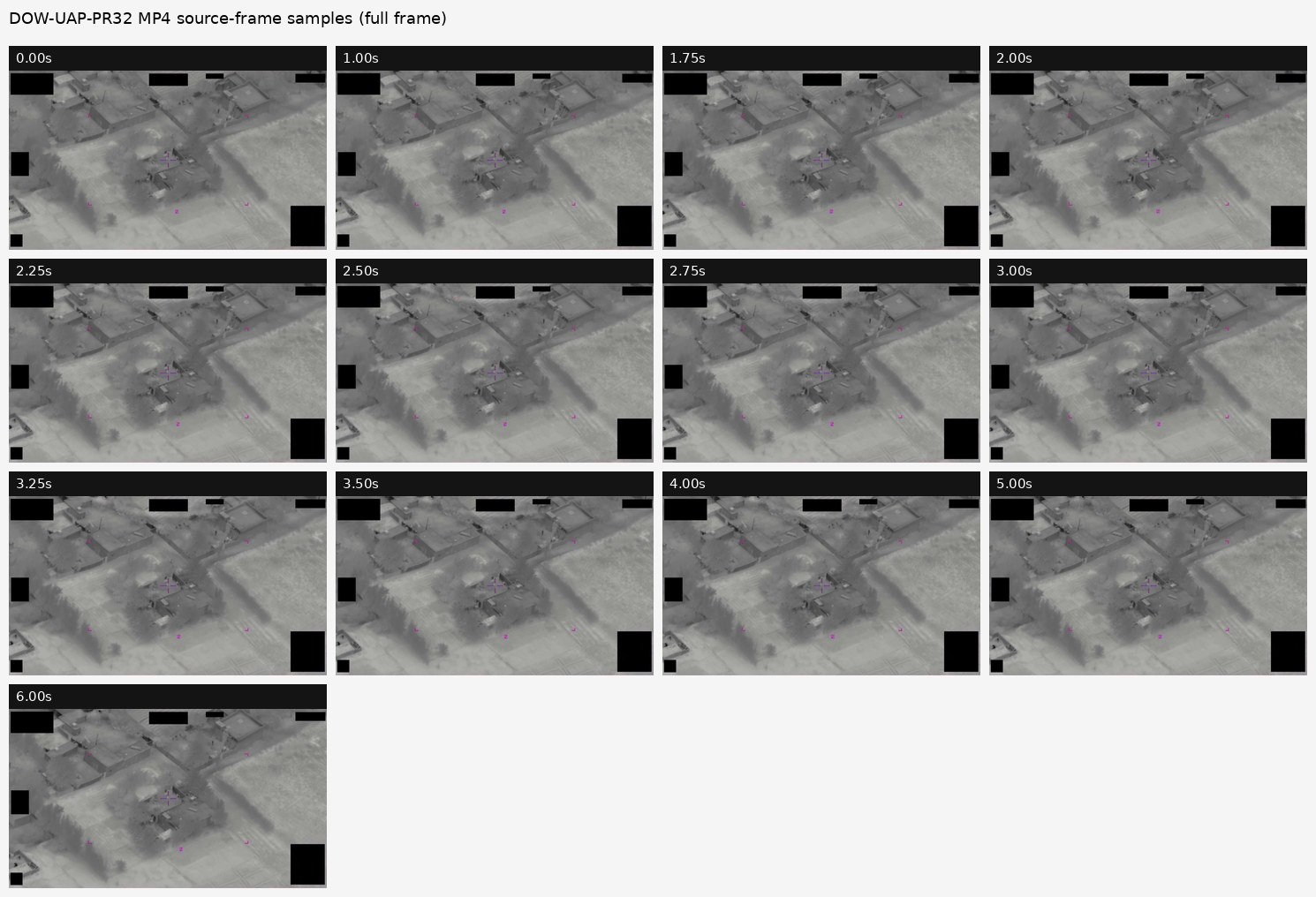
- Open Sky release-file copy of the official PR32 MP4 — verified as a 1,834,659-byte, 6.60-second MP4 with SHA-256
74bd47f0b608c19367b673ba186071db725719eebc7c7b251b8ef2b944c6427e. - Derived full-frame contact sheet from the official PR32 MP4 — included for scene, masking, and overlay context across sampled frames from
00:00to00:06.
Derived frame context from the official PR32 MP4 is included below. The image is a top-band crop contact sheet from sampled frames, not standalone object imagery.
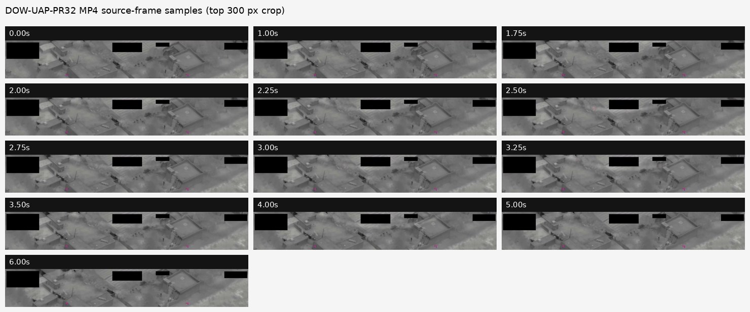 The crop sheet samples the upper display band where the DVIDS description places the red/white highlight area. It shows edge-adjacent pale highlights and faint red/magenta color near black masks and display overlays; the source of those highlights remains unresolved from the public clip alone.
Investigation reading
This is the DVIDS video record paired by the release materials with DOW-UAP-D32, Mission Report, Syria, October 2024. The reviewed source is a 1,834,659-byte MP4, 6.60 seconds long, 1920×1080 H.264 at 30 fps, with an AAC stereo audio track that is effectively silent in the reviewed copy. The verified SHA-256 is 74bd47f0b608c19367b673ba186071db725719eebc7c7b251b8ef2b944c6427e.
The video shows a short FMV-style overhead view of a rural or semi-rural compound, roads/tracks, open fields, and vegetation. The view is mostly grayscale and sensor-like. Multiple solid black rectangles obscure display areas, and magenta/purple interface marks or brackets sit over the scene. Those masks and symbology are release/video-display elements, not independent objects in the landscape.
The official DVIDS description says the six-second clip shows, from roughly 00:02 to 00:04, an area of irregular color and brightness near the center of the top edge of the sensor display, mainly white and red highlights, roughly one-third of the frame width and one-sixth of the frame height, described as a horizontally oriented half-oval bisected along its major axis. Direct frame review found a small red/white irregular feature most visible around 00:02.5 in the upper-left-of-center/top-edge area, with pale/white detail recurring in roughly the same region across nearby frames. At contact-sheet scale the feature is not sharply resolved, and the red component is not persistent with the same strength across all sampled frames.
What the file appears to contain
The clip appears to be a short, compressed FMV excerpt rather than a full mission video. Across sampled frames the background scene remains broadly stable: roof-like rectangles, compound walls or yards, dirt tracks, field texture, and darker vegetation or shadow-like patches. No readable timecode, coordinates, platform identifier, or full display metadata are visible because several areas are blacked out.
The visible top-edge feature is small, irregular, and partly affected by the frame boundary and surrounding low-detail image texture. It is distinct from the sharp magenta bracket overlays and from the large black redaction blocks, but the clip alone does not establish whether the feature is scene content, optical glare, display/sensor behavior, compression/color processing, or another prosaic visual effect. No confident object identification, speed, distance, altitude, or path can be extracted from this short public clip alone.
Source custody and provenance
The official DVIDS page is:
The Open Sky release-file endpoint for the reviewed MP4 is:
DVIDS metadata for the page lists video ID 1006078, VIRIN 241002-D-D0360-2794, filename DOD_111688997, category B-Roll, length 00:00:06, location SY, date taken 10.01.2024, and date posted 05.07.2026 23:28. Release 01 metadata and graph context associate the video with Department of War CSV rows 49 and 89, incident location Syria, and the paired D32 mission-report context. The DVIDS date/VIRIN fields and the D32 incident-date context should be reconciled before using the date fields as precise event timing.
Graph context
The graph models this item as an official primary VideoEvidence record plus a related release-record Document. The current semantic context attached to the video has 31 extracted claims, 21 entity mentions, 3 FMV-oriented sensor-event records, and no table rows. These are navigation aids for review, not findings.
The strongest source-backed graph signals are the DVIDS/Department of War custody, the FMV platform context, the location label Syria, and the release description tying PR32 to the D32 mission report. The most relevant related source is the D32 PDF, whose reviewed page records a 201559:00ZOCT24 initial-contact field and a narrative describing a MISHAPEN AND UNEVEN BALL OF WHITE LIGHT plus glare/halo effects in the FMV feed. PR32 should be compared against D32, PR31, and PR33 before any timestamp alignment or clip-to-report mapping is treated as checked.
Location-only or broad-anchor crosslinks surfaced by the graph should remain leads only. They do not show same-event corroboration without a source-by-source match.
Leads to check
- Compare PR32 against PR31 and PR33, then align all three clips against the D32 timeline entries at
1559Z,1602Z,1609Z,1620Z, and1644Z. - Check whether the small red/white top-edge feature is present in adjacent frames, higher-quality source copies, or any unredacted display export.
- Run optical and sensor-display checks: lens/glare behavior, top-edge frame artifacts, sensor saturation, compression/color processing, platform motion, and release overlay placement.
- Reconcile DVIDS
Date Taken/ VIRIN date cues with the Release 01 incident-date and D32 mission-report fields before citing exact dates beyond the broad October 2024 context. - External weather, astronomy, satellite, launch/reentry, aircraft, and drone checks need unredacted geometry or defensible approximations; this MP4 alone does not provide enough location/time detail.
Lead check notes
- Partial — PR31/PR32/PR33 alignment: The paired D32 source page and the PR31/PR32 video pages confirm that the short DVIDS clips are grouped with the same Syria October 2024 mission-report cluster. PR32 source-frame samples cover the
00:02-00:04description window, but a clip-to-report mapping still needs PR33 frame review and an authoritative way to align the public clip windows with D32's1559Z,1602Z,1609Z,1620Z, and1644Zsource statements. - Partial — top-edge highlight/artifact checks: The verified PR32 MP4 and derived top-band contact sheet preserve edge-adjacent pale highlights and faint red/magenta color near the top display band, black masks, and overlay areas during the described window. The public clip does not establish whether the highlights are scene content, optical glare, frame-edge behavior, display processing, compression/color processing, or another prosaic video effect.
- Checked — D32 descriptive quote distinction: The paired D32 page preserves the source spelling
MISHAPEN AND UNEVEN BALL OF WHITE LIGHT; the DVIDS/video description uses normalizedmisshapenwording. Public quotations should keep the distinction. - Partial — date and row provenance: PR32 carries DVIDS ID
1006078, rows49/89, and DVIDS date/VIRIN cues that do not by themselves settle the D32 incident-date context. Treat the10/01/2024DVIDS/VIRIN cue, the10/20/2024D32 incident date, and the PR31/PR32/PR33 row group as release-provenance items until an authoritative manifest history reconciles them. - Needs external source — environment and traffic checks: Weather, astronomy, satellite, launch/reentry, aircraft, drone, line-of-sight, and sensor-geometry checks still need unredacted coordinates, platform geometry, raw or higher-fidelity FMV, or a defensible official approximation; the public PR32 MP4 alone does not provide that.
Deep investigation — graph + web reconnaissance
Source reread
A second pass rechecked the official DVIDS page text, the verified Open Sky release-file MP4, the full-frame contact sheet, the top-band contact sheet, and the paired D32 mission-report page. PR32 is a short DVIDS B-Roll MP4, DVIDS video ID 1006078, filename DOD_111688997, VIRIN 241002-D-D0360-2794, listed by DVIDS as location SY, date taken 10.01.2024, date posted 05.07.2026 23:28, and length 00:00:06. The reviewed MP4 is 1,834,659 bytes with SHA-256 74bd47f0b608c19367b673ba186071db725719eebc7c7b251b8ef2b944c6427e.
The source description says the 00:02-00:04 window contains irregular color and brightness near the center of the top edge of the sensor display, mainly white and red highlights, broadly half-oval in the publisher's description. Source-frame review keeps that narrower: the full-frame contact sheet shows a masked grayscale aerial-style scene with structures, roads/tracks, fields, and vegetation; the top-band sheet shows persistent black masks, magenta/pink interface marks, and faint red/white or magenta-tinted highlights during the described window. The contact sheets do not resolve the highlight into a diagnostic object, and they do not support measuring range, altitude, speed, size, or independent motion.
Graph connections checked
Read-only Neo4j reconnaissance matched the exact VideoEvidence asset official:video:war-pursue-uap-release:dvids-1006078, its canonical DVIDS URL, MP4 byte count, MP4 SHA-256, and related CSV rows 49 and 89. The graph has two manifest-description text chunks, 31 machine-extracted Claim records, 21 EntityMention records, and three FMV-oriented SensorEvent records for this video. Those are review/navigation aids, all still machine_extracted_needs_human_review / not_a_finding; they do not create an identification or resolution.
The stable source cluster remains D32 plus the three short Syria October 2024 DVIDS videos: PR31 (1006076), PR32 (1006078), and PR33 (1006079). The paired D32 PDF provides the source timeline and language: MISHAPEN AND UNEVEN BALL OF WHITE LIGHT, direct FMV light/glare crossings at 1559Z, 1602Z, and 1644Z, and top-of-feed halo effects at 1609Z and 1620Z. PR32's public seconds have not been authoritatively mapped to any one of those D32 timeline entries. Direct graph CANDIDATE_CROSSLINK checking returned no same-event corroboration for PR32, and stale row/navigation relationships to Greece PR35/D35 records should be treated as provenance cleanup, not evidence.
Official web reconnaissance
The DVIDS PR32 page was reachable during this check and matched the title, video ID, VIRIN, filename, date-posted field, category, length, and source description summarized above. A direct CloudFront range request for DOD_111688997.mp4 returned 206 Partial Content, Content-Range: bytes 0-15/1834659, and MP4 ftyp magic, supporting that the public media file is the same 1,834,659-byte video family. Direct WAR.GOV/PURSUE landing and CSV requests returned access-denied responses; Internet Archive availability for the DVIDS URL returned a rate-limit response, so neither was used as replacement custody here.
Prosaic checks and open limits
The first prosaic lane is optical/display/sensor handling: glare, top-edge frame effects, false-color or thermal processing, black-mask boundaries, magenta symbology, compression/resampling, and platform/sensor motion. Graph labels for AstronomyEvent, WeatherEvent, and LaunchEvent exist in the database, but exact-date graph probes for 2024-10-20 and a narrow launch window returned no modeled rows. That is only a graph-coverage note, not an external exclusion, because the public PR32 video and D32 PDF still lack unredacted coordinates, line of sight, platform track, sensor settings, weather at the look vector, traffic/drone context, and raw FMV metadata.
Audit note
This deep pass made no Neo4j writes and made no finding. It tightened the public page around source hierarchy: official DVIDS and verified MP4 first, paired D32 source text second, graph extraction as machine-review context, and prosaic checks before escalation. Follow-up should align PR31/PR32/PR33 frame windows against the D32 timeline only if higher-fidelity video, unredacted metadata, or an official mapping is available.
Limits
This page is an investigation draft, not an identification or resolution. The public video is only 6.6 seconds long, compressed, partly redacted, and displayed with magenta symbology. It does not provide full metadata, raw sensor files, unredacted coordinates, platform details, or enough context to measure the feature independently.
The official description is useful source text, but it explicitly cautions that readers should not treat the description as an analytical judgment, investigative conclusion, or factual determination. Open Sky preserves the same posture here: the visible feature is unresolved in this public clip and needs human review against the paired source record and prosaic checks.
Sources
- DVIDS official video page: DOW-UAP-PR32, Unresolved UAP Report, Syria, October 2024
- DVIDS MP4 filename:
DOD_111688997; video ID1006078; VIRIN241002-D-D0360-2794. - Open Sky release-file copy: war-gov-dow-uap-pr32-unresolved-uap-report-syria-october-2024-1006078
- SHA-256:
74bd47f0b608c19367b673ba186071db725719eebc7c7b251b8ef2b944c6427e - Paired source document: DOW-UAP-D32, Mission Report, Syria, October 2024