DOW-UAP-PR20, Unresolved UAP Report, Kuwait, May 2022
Evidence media
- Official PDF: Open Sky release-file copy · WAR.GOV source
The images below are derived from the official PDF. They are source-document/raster views of the released still-image sheet, not a raw sensor export, unannotated original frame, or independent analysis product.
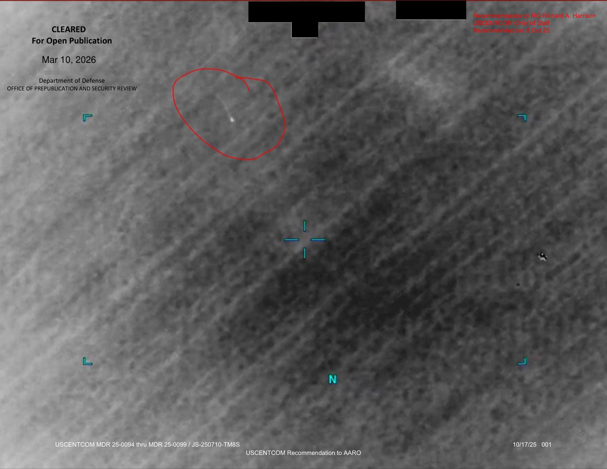
This page render shows the released landscape still-image sheet with top redactions, a red circled small bright elongated mark in the upper-left portion, cyan display symbology including an N marker, the DoD open-publication clearance stamp, the MG Richard A. Harrison / USCENTCOM Chief of Staff recommendation text, and the USCENTCOM Recommendation to AARO footer.
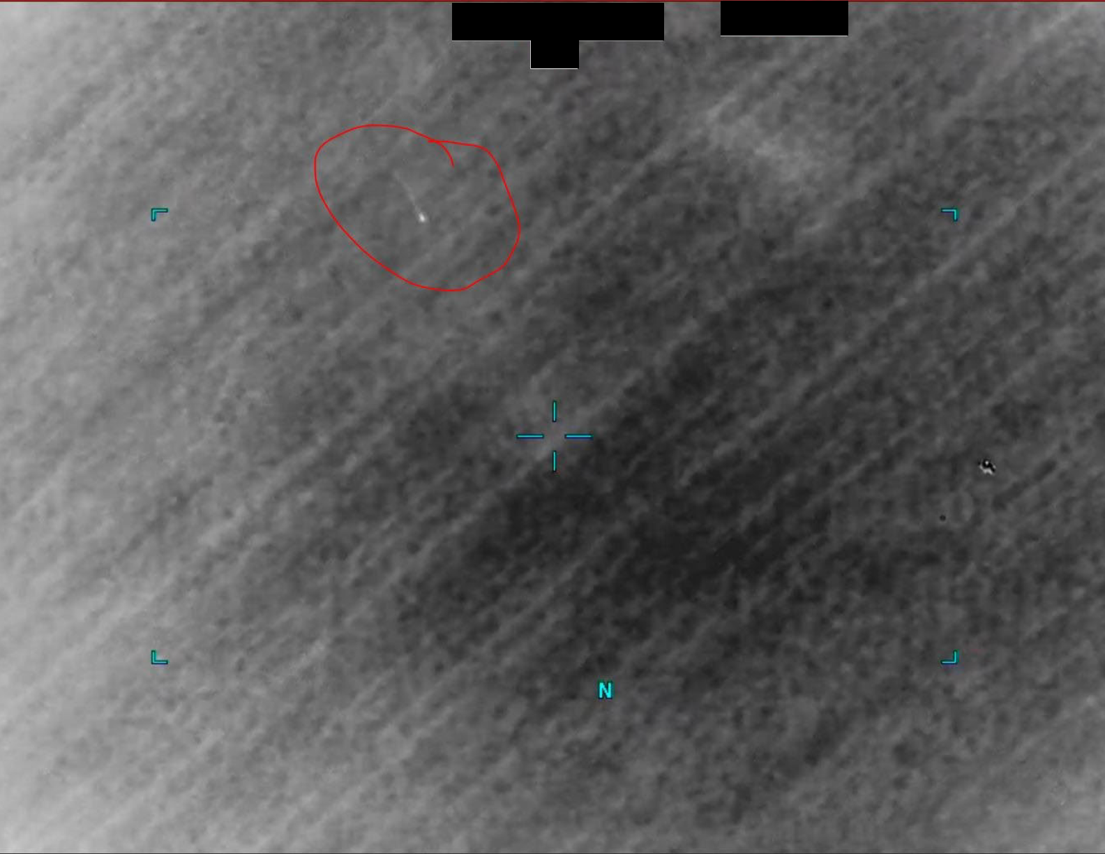
The extracted raster shows that the red circle, black top redactions, cyan display brackets/crosshair, and N orientation marker are baked into the image object. The clearance stamp, recommendation text, and footer are PDF page overlays outside the extracted raster image.
Investigation reading
This is a one-page still-image PDF, not a full mission report. The release description says USCENTCOM submitted a still image derived from a U.S. military system to AARO, and that the original reporter added a red circle around the area of interest before submission. The same description ties the image to the accompanying mission report DoW-UAP-D12, which describes one UAP moving north to northeast before the operator could not get a positive identification.
The page itself is a single landscape grayscale sensor-style frame with release markings, redactions, a red circled area in the upper-left portion, cyan display symbology, and a footer identifying the page as a USCENTCOM recommendation to AARO. The circled feature is small and unresolved in this public copy. This draft records what the released file visibly contains and what the graph currently connects to it; it does not identify the feature or resolve the event.
This page is a graph_investigation_draft; it needs human review and remains not_a_finding.
What the file appears to contain
The PDF has one page and one embedded raster image, about 1584 x 1224 pixels inside a 2,292,342 byte PDF. The rendered page shows the image filling the page, with separate release/publication text overlaid in the PDF.
Visible source-image content:
- A mottled grayscale field with low-contrast terrain-, cloud-, or sensor-texture-like patterns. The page does not provide scale, sensor mode, platform name, timestamp, or geolocation in the visible image field.
- Cyan display symbology: corner/bracket marks, a central crosshair-like marker below center, and an
Norientation marker near the lower center. - A red freehand circle in the upper-left quadrant around a very small, bright, elongated mark. The mark appears as a short bright dash or streak against a darker background, but there is not enough visible detail in this released frame to determine what it is.
- Additional small bright/dark specks are visible outside the circled area, including in the lower-right quadrant, but the PDF provides no explanatory label for them.
Visible release or administrative content:
- Upper-left clearance stamp:
CLEARED,For Open Publication,Mar 10, 2026, andDepartment of Defense OFFICE OF PREPUBLICATION AND SECURITY REVIEW. - Upper-right recommendation text:
Recommendation by MG Richard A. Harrison,USCENTCOM Chief of Staff,Recommended on: 8 Oct 25. - Black redaction blocks across the top portion of the frame.
- Bottom footer text:
USCENTCOM MDR 25-0094 thru MDR 25-0099 / JS-250710-TM8S,USCENTCOM Recommendation to AARO, and10/17/25 001.
The manifest description adds two important context statements that are not independently resolvable from the still image alone: first, that the image came from a U.S. military system in 2022; second, that the paired DoW-UAP-D12 mission report describes the UAP as moving north to northeast.
Source custody and provenance
- Official PDF: https://www.war.gov/medialink/ufo/release_1/dow-uap-pr20.pdf
- Open Sky release-file copy: war-gov-dow-uap-pr20-unresolved-uap-report-kuwait-may-2022-1b522e77
- Agency: Department of War
- Source type: one-page PDF containing a still-image sheet
- File size:
2292342bytes - PDF page count:
1 - Embedded image count:
1 - Embedded image dimensions:
1584 x 1224 - OCR/text coverage:
1page with text - SHA-256:
1ff8c16256579734969188915ad0e80062e1d5639bc424c6a207340e892c6dc6
The Open Sky release-file copy matches the SHA-256 above. The text layer and OCR both preserve the clearance stamp and footer; the rendered page/text layer also resolves the upper-right recommendation text by MG Richard A. Harrison. The public release metadata has a custody tension to preserve: the title says Kuwait, May 2022, while the structured release record and video-title field point to Iraq / Unresolved UAP Report, Iraq, May 2022, and the image is paired with DoW-UAP-D12, Mission Report, Iraq, May 2022.
Graph context
Open Sky currently models this item as a Release 01 PDF asset and a related release-record document. The asset node points to the canonical WAR.GOV PDF and preserves the verified hash. The release-record context ties the file to Department of War Release 01 metadata, redaction marked true, N/A incident date, and an Iraq location field.
The semantic graph currently has 37 extracted claim records, 23 entity mentions, 4 sensor-event records, and 2 candidate crosslinks for this item. The useful source-backed graph content is narrow: still image; military system; AARO/USCENTCOM/Department of War; 2022; paired DoW-UAP-D12; north-to-northeast motion in the paired mission report; and the operator's inability to positively identify the UAP.
The four sensor-event records should be read as navigation cues, not as independent instrument confirmation. They come from the release description phrases still image and military system; the PDF does not include a raw radar plot, sensor metadata table, video sequence, or platform geometry. The candidate crosslinks and some related-record context appear to be broad anchor or row-neighbor matches, not evidence that PR20 is connected to those separate cases.
Leads to check
- Review the paired
DoW-UAP-D12mission report alongside this still image, but keep the two source files distinct: D12 is the text MISREP; PR20 is the released still-image sheet. - Locate any unannotated original frame, adjacent frames, thumbnail lineage, or raw sensor export. The public PR20 file includes a red circled annotation and top redactions, so it is not enough for image-level adjudication.
- Reconcile the title/location tension:
Kuwaitin the PR20 title versusIraqin the structured release record and paired D12 context. - Determine whether the red circle was added before AARO received the image, as the manifest says, and whether any unaltered version was preserved elsewhere in the release chain.
- Check ordinary image-quality explanations before escalation: compression, scan conversion, display symbology, sensor bloom, small-pixel artifacts, and line-of-sight ambiguity.
- If legally available, recover missing sensor/time/platform/location metadata needed for geometry: exact timestamp, platform position, altitude, sensor mode, field of view, range, and orientation.
Lead check notes
- Checked — paired D12 source kept distinct: the paired D12 mission-report page preserves the source text for
202043:00ZMAY22, one UAP sighted, north-to-northeast motion, and the screener's inability to get a positive identification. PR20 supplies the released still-image sheet only; motion and failed positive identification are D12/manifest context, not motion visible in this single frame. - Checked — image layers separated: the official PDF contains one embedded RGB image (
1584 x 1224) inside a one-page landscape sheet. The page render shows the PDF clearance stamp, recommendation text, and footer; the extracted raster shows the red circle, black top redactions, cyan display brackets/crosshair, andNmarker baked into the image object. - Partial — title/location provenance: the PR20 title and official URL identify
Kuwait, May 2022, while the structured release record and paired D12 context identifyIraq. Treat that as a release-metadata tension until corrected official manifest history or an unredacted source package resolves it. - Blocked — unannotated/adjacent media: current Release 01 metadata exposes PR20 as a PDF asset and no PR20 video item, and the PDF reports no embedded attachments. Image-level adjudication still needs an unannotated original frame, adjacent frames, raw sensor export, exact timestamp, platform geometry, and source-chain explanation for the reporter-added red circle.
- Needs external source — image-quality and prosaic checks: the released PDF supports only a small bright elongated mark/streak inside the red circle and a few other small specks in the frame. Compression, scan conversion, display-symbol alignment, sensor bloom, small-pixel artifacts, line-of-sight ambiguity, weather, traffic, and astronomy checks require source media or geometry not present in the public PDF.
Deep investigation — graph + web reconnaissance
Source reread and visual check
A fresh source pass verified PR20 as a one-page landscape PDF containing one embedded RGB image (1584 x 1224, 144 ppi) inside a 2,292,342 byte file with SHA-256 1ff8c16256579734969188915ad0e80062e1d5639bc424c6a207340e892c6dc6. The text layer preserves the DoD open-publication clearance, MG Richard A. Harrison / USCENTCOM recommendation text, and the USCENTCOM Recommendation to AARO footer. The OCR layer also records the redaction and red-circle note, but the rendered page is stronger for the page markings and the extracted raster is stronger for separating image content from PDF overlays.
Visual review keeps three layers separate. The PDF page overlays include the clearance stamp, recommendation text, and footer. The embedded raster already contains the red hand-drawn circle, black top redactions, cyan bracket/crosshair symbology, and N orientation marker. The red circle encloses a tiny bright elongated mark or short streak in the upper-left part of the frame; the public still does not establish scale, altitude, speed, distance, sensor mode, or physical identity. The manifest/D12 context supplies the north-to-northeast motion and failed positive-identification statements; those are not motion measurements visible in this single still.
Cached manifest review preserves a row-position tension worth tracking. The source-pack page uses row 77, while a current CSV snapshot places the same PR20 title on physical line 81 / data row 80. That looks like release-manifest revision drift, not a separate event. The PR20 title says Kuwait, while the structured release record, video-title field, and paired DoW-UAP-D12 context point to Iraq.
Graph connections
Read-only Neo4j review found two exact PR20 document records: the current Release 01 row record and the PDF asset record with the canonical WAR.GOV PDF URL and verified full-download hash. The exact PR20 graph neighborhood has 4 text chunks, 37 machine-extracted Claim records, 23 EntityMention records, 4 SensorEvent records, 2 official-source INGESTED_FROM links, 4 RELATED_TO document links, and 2 candidate crosslinks.
The useful source-backed graph trail is narrow: Department of War / USCENTCOM / AARO provenance, the PR20 PDF asset, the still-image description, the reporter-added red circle, the paired DoW-UAP-D12 mission-report reference, the north-to-northeast context statement, and the operator's inability to positively identify the UAP. No direct graph relationship currently links the PR20 asset node to the exact D12 document nodes; the pairing is preserved in the CSV/manifest text (PDF Pairing: DoW-UAP-D12) and machine claims, so it should remain a source-text pairing rather than a merged case record.
The SensorEvent records are machine-review navigation cues, not independent sensor confirmation. They come from phrases such as still image and military system and are marked not_a_finding. Related-document review also surfaced stale/non-current row-neighbor drift involving D75 and PR23 records, plus low-score candidate crosslinks to a 1961 Gulf of Aden NARA document and the Condon Report optics chapter. Those are provenance-cleanup or broad optical-context leads only; they do not corroborate PR20.
External provenance and web context
Official web probes kept WAR.GOV as the canonical source but could not live-fetch the official material during this check: the PR20 PDF, Release 01 landing page, and both probed CSV paths returned 403. Internet Archive availability/CDX probes for the exact PR20 PDF returned 429/503, so archived availability should be retried later. DVIDS title search returned an empty 202 response, and AARO/Defense.gov title probes returned 403. The verified Open Sky release-file copy and recorded WAR.GOV manifest metadata remain the custody anchor for this page.
Exact-title public web reconnaissance found reachable secondary mirrors/pages for comparison, including Disclosdex (PURSUE Release 01: DOW-UAP-PR20, Unresolved UAP Report, Kuwait, May 2022), Unexplainable.com, UFOlens, and GitHub-derived release listings. These are useful discovery and wording-comparison leads because they repeat the PR20/D12 pairing and title, but they are not independent provenance and should not replace the official WAR.GOV URL, release manifest, or verified file hash.
Prosaic checks and limits
The best ordinary-check lane is still image provenance and image-quality review before escalation: an annotated still can amplify attention to a tiny bright mark, but it cannot by itself resolve whether the mark is an object, sensor glint, compression/sharpening artifact, small cloud/terrain contrast, display artifact, bloom, or another pixel-scale effect. The missing unannotated original frame, adjacent frames, raw FMV/sensor export, timestamp, field of view, range, platform geometry, and look direction are all material blockers.
Using the paired D12 date/location context only as a lead, read-only graph probes found no modeled AstronomyEvent on 2022-05-20 and no modeled Iraq weather record for that date/location key. A launch-window probe for 2022-05-18 through 2022-05-22 returned one modeled launch, Starlink 4-18 (v1.5) at 2022-05-18T10:40:00Z, but without exact PR20/D12 location, look direction, timing tie, and sensor geometry it is not a correlation. Absence of a graph correlate is not a resolution; it only marks what the current graph can and cannot test.
Follow-up leads
- Obtain or identify an authoritative unannotated PR20 frame, adjacent frames, or raw FMV export and verify whether it is actually tied to D12's
2043Zreport rather than only to release-family metadata. - Reconcile PR20
Kuwaittitle wording with theIraqstructured record and paired D12 mission report, and reconcile row77/ current data-row80manifest drift. - Retry official WAR.GOV PDF/CSV/landing and Internet Archive exact-URL probes from a network path that can access the official site; record content length, hash, timestamp, and title if a snapshot is available.
- Treat DVIDS, AARO, Defense.gov, Disclosdex, Unexplainable.com, UFOlens, and GitHub mirrors as leads unless they provide exact official source custody or additional primary media.
- Keep machine-extracted sensor/claim records as
not_a_findinguntil each claim is checked against source text or released imagery.
Audit note
This section was added from the source PDF hash/metadata check, text/OCR review, rendered-page and embedded-raster visual review, paired D12 page context, read-only graph queries, official-source availability probes, and bounded secondary web reconnaissance. No Neo4j writes were made, and no Finding, Hypothesis, or ResolutionDecision conclusion is asserted here.
Limits
The public PDF gives a single annotated still image. It does not provide a time-stamped sequence, scale bar, range, sensor make/model, platform identity, altitude, exact location, weather context, or unredacted source metadata. The small circled bright feature is visible, but the released page alone does not support an identification, performance estimate, or resolution.
The north-to-northeast motion and failed positive identification are source-context statements from the paired mission report/manifest description, not measurements visible in this one image. This page therefore preserves provenance and visual context only. It does not assert that the feature is extraordinary, prosaic, airborne, or even the same feature that would be analyzed in an unannotated source frame.
Sources
- Department of War, WAR.GOV/PURSUE Release 01,
DOW-UAP-PR20, Unresolved UAP Report, Kuwait, May 2022, official PDF: https://www.war.gov/medialink/ufo/release_1/dow-uap-pr20.pdf - Open Sky release-file copy for public browsing: war-gov-dow-uap-pr20-unresolved-uap-report-kuwait-may-2022-1b522e77
- Related Release 01 mission report:
DoW-UAP-D12, Mission Report, Iraq, May 2022 - WAR.GOV Release 01 manifest description for PR20, including the AARO/USCENTCOM still-image description and D12 pairing.