DOW-UAP-PR34, Unresolved UAP Report, Greece, October 2023
Evidence media
- Open Sky release-file copy of the official PR34 MP4 — verified as a 198,248,609-byte MP4 with SHA-256
34eb85ab42bb6ce5d376c02fd2db4eee0211864ed3bcd8a8247a08fe0da8c99e. - Paired source context: DOW-UAP-D33 mission-report page. D33 supplies the source-text timing, near-ocean-surface wording,
80 MPHestimate, and lost-feed note; PR34 is the separate released video source.
Derived frame context/contact sheets from the official MP4 are included below for orientation. They are review images made from the released video frames, not standalone object identifications.
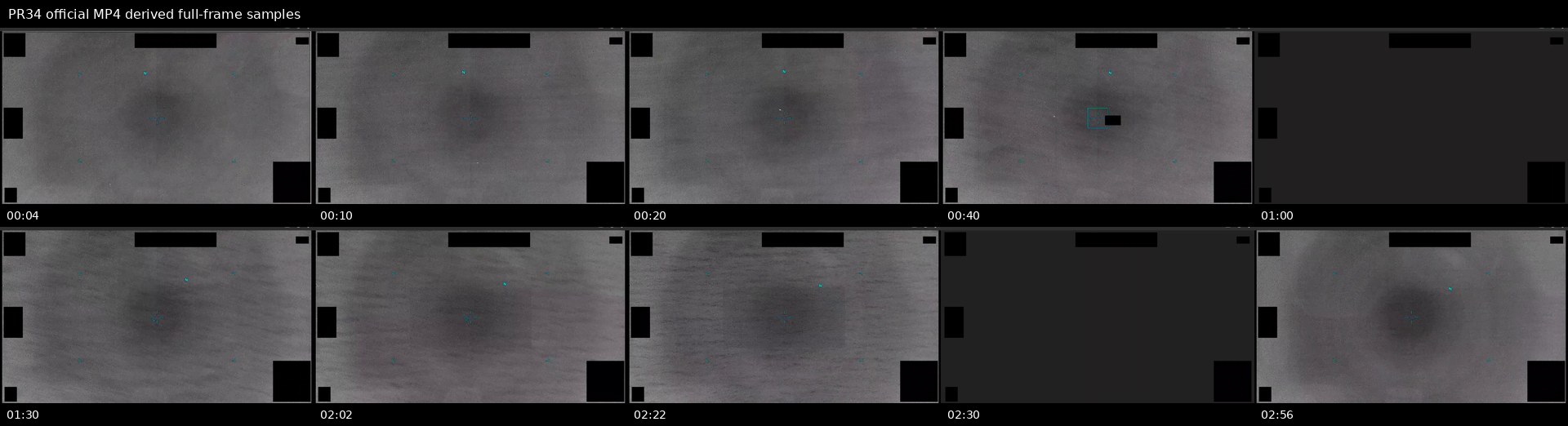 Full-frame samples at selected timestamps show the low-contrast grayscale sensor view, black masking/redaction blocks, cyan/teal display symbology, reticle behavior, and contrast/zoom changes. The samples do not resolve a discrete object by themselves.
![]() The crop samples preserve the lower-left entry, central tracking, reticle/filter, and post-lock-loss windows in a smaller field of view. Small points or diffuse patches remain unresolved and should not be read as shape, scale, distance, or cause.
The crop samples preserve the lower-left entry, central tracking, reticle/filter, and post-lock-loss windows in a smaller field of view. Small points or diffuse patches remain unresolved and should not be read as shape, scale, distance, or cause.
Investigation reading
This page covers the PR34 video source item: DVIDS video 1006080, released in the WAR.GOV/PURSUE Release 01 corpus and associated in release metadata with DOW-UAP-D33, Mission Report, Greece, October 2023. The cached release-file copy was verified as a 198,248,609-byte MP4 with SHA-256 34eb85ab42bb6ce5d376c02fd2db4eee0211864ed3bcd8a8247a08fe0da8c99e. Media metadata reads as H.264 video, 1920×1080, 30 fps, 177.2 seconds. An AAC stereo audio stream is present, but volume analysis found it effectively silent at about -91.0 dB mean and maximum volume.
The publisher description says the video is infrared footage from a U.S. military platform in 2023. It frames the visible target as an “area of contrast,” not as a resolved object. The accompanying D33 mission report says a military operator observed a UAP flying just above the ocean surface, taking multiple 90-degree turns, and moving at an estimated 80 mph. Those are source statements from the release; this draft does not turn them into a finding.
A full-clip frame pass was performed across the official timeline: the entry window around 00:04, the horizontal-tracking window around 00:07–00:19, the centered-tracking span, the reticle/lock interval, the contrast-filter window, the reported loss-of-lock around 02:22, and the final zoom/threshold cycling. The direct visual review supports a cautious reading: the imagery is monochrome infrared/sensor footage with black masks/redactions, cyan/teal display symbology, reticles, and processing changes. The underlying scene is low-detail and ocean/terrain-like; the relevant visual feature is best described as a low-contrast area or diffuse dark patch in the sensor view. The frames reviewed do not by themselves identify an object, vehicle, biological target, platform, or cause.
What the file appears to contain
| Segment | Public reading |
|---|---|
| File format | Official MP4 video, 2:57.2 long, 1920×1080, 30 fps, H.264, with effectively silent AAC audio. |
00:00–00:06 | Grayscale sensor view with black masking and cyan/teal overlay symbology. Around the publisher-described 00:04 entry point, a faint, diffuse darker contrast area is visible near the lower-left portion of the scene, but it is not sharply bounded or independently identifiable. |
00:07–00:19 | The publisher says the contrast area moves back and forth as the sensor pans. Frame samples show low-contrast gray background texture, subtle dark patches, and display symbology. Motion should be assessed from the video sequence rather than still frames alone. |
00:20–01:00 | The description says the contrast area remains generally centered. Frame samples show a recurring diffuse darker region near the central field, with no resolved shape, structure, or independent scale cue visible in the draft review. |
01:00–02:01 | The description says the sensor designates the area with a blue reticle. The sampled frames show persistent cyan/teal reticle and heading/display marks; these are display overlays, not physical scene content. |
02:02–02:21 | The description says a contrast filter is engaged. Around the later sampled frames, a high-contrast rectangular processing region appears over part of the scene. Its straight edges and different noise/contrast behavior are consistent with display or processing behavior, not a natural rectangular object. |
02:22–end | The description says the area becomes indistinguishable and the reticle drops lock, followed by zoom and contrast-threshold cycling. The final sampled frames remain low-detail, with broad tonal patches and no standalone object identification. |
The most important reading distinction is between the scene and the display layer. The black rectangles are masks/redactions or display blocking. The cyan/teal marks, reticle, and heading indicators are symbology. The contact-time labels used in review are review labels, not source-scene content. The video may preserve a real sensor-tracking episode, but this page records only what the released media and accompanying description support at draft level.
Source custody and provenance
- Official/source URL: DOW-UAP-PR34, Unresolved UAP Report, Greece, October 2023
- Open Sky release-file copy: war-gov-dow-uap-pr34-unresolved-uap-report-greece-october-2023-1006080
- SHA-256:
34eb85ab42bb6ce5d376c02fd2db4eee0211864ed3bcd8a8247a08fe0da8c99e - File size checked:
198,248,609bytes - Media metadata checked:
177.2seconds,1920×1080,30 fps, H.264 video, AAC stereo audio effectively silent in the released file. - DVIDS video ID:
1006080; MP4 asset ID in the graph:official:video:war-pursue-uap-release:dvids-1006080. - Release metadata links this video to
DOW-UAP-D33, Mission Report, Greece, October 2023, whose reviewed page records the companion PDF as a seven-page MISREP-style report for the Aegean Sea / Greece event. - Row-number provenance needs cleanup: the video release metadata stores related CSV rows
51and91, while the current manifest/graph record exposed during review also surfaces PR34 as row88and paired D33 as row48. Treat row numbers as a release-metadata audit lead, not as an evidentiary conclusion.
Graph context
The evidence graph has an exact VideoEvidence record for DVIDS 1006080 and an exact Release 01 Document record for the PR34 manifest row. The same graph context also surfaces the paired D33 mission-report record and a related D33 PDF asset. The semantic layer currently reports 22 extracted claims, 12 entity mentions, no extracted sensor-event records, and no extracted table rows for the PR34 video item.
The graph claims are dominated by the official release description: D33/PR34 identity, Department of War / AARO / DVIDS references, Greece/Aegean location terms, the operator-reported near-surface observation, the multiple 90-degree-turn / 80 mph language, and the official caution that the description is not an analytical judgment or factual determination of the event’s nature or significance. Those claims are useful navigation cues, not adjudicated findings.
Candidate crosslinks around Greece, Syria, DVIDS, and older UFO literature are lexical or batch-neighbor leads. They do not establish corroboration. The strongest local relation is the release-described pairing with the D33 mission-report page, which should be read alongside this video page for form fields, timing, and missing-data limits.
Leads to check
- Compare the PR34 video sequence against the D33 page-level fields: initial contact around
270035:12ZOCT23, lost-feed wording around0038Z, near-ocean-surface description, estimated80 MPH, and “multiple 90-degree turns.” Keep any timing or wording mismatch as a source-quality lead. - Review the tracking/reticle behavior in the continuous video, not only sampled frames: sensor pan, lock designation, contrast filter, reticle drop, zoom changes, and whether apparent motion could be affected by platform motion, stabilization, field-of-view changes, or display processing.
- Run prosaic correlation checks before escalation: sea-surface traffic, wakes, birds, wave/wind contrast, sensor glare/thermal contrast, compression, display masking, and local weather/visibility for the redacted Aegean/Greece geometry if enough public location data can be recovered.
- Reconcile row-number metadata across the video release metadata, current manifest row, graph records, and the paired D33 PDF record.
- If public deployment later adds derived frame context, label it explicitly as derived review imagery from the official MP4 and keep overlays, masks, reticles, and processing windows separate from scene content.
Lead check notes
- Partial — D33/PR34 source alignment: The PR34 release description explicitly pairs the MP4 with D33, and the D33 page-level review preserves
270035:12ZOCT23,0038Z, near-ocean-surface wording,80 MPH, and multiple 90-degree-turn language. The MP4 itself does not expose mission-clock timestamps, unredacted coordinates, platform track, range, or calibration needed to independently measure those fields. - Partial — reticle, filter, and apparent motion review: The released MP4 and derived contact sheets show low-contrast grayscale sensor imagery, black masks/redactions, cyan/teal display symbology, reticle/lock behavior, a contrast/filter window, and later zoom/threshold cycling. They do not by themselves separate target motion from platform motion, stabilization, field-of-view changes, display processing, or compression.
- Needs external source — prosaic correlation: Sea-surface traffic, wakes, birds, wind/wave contrast, sensor glare/thermal contrast, weather/visibility, astronomy, satellite/reentry, and platform-geometry checks remain open because the public PR34/D33 materials do not provide exact unredacted location, platform track, sensor settings, range, or contemporaneous environmental data.
- Partial — row and provenance cleanup: Current graph/release context ties the video to DVIDS
1006080, video rows51/91in release metadata context, a current PR34 row88, and paired D33 row48. That is enough to preserve the D33/PR34 pairing, but row-number differences remain a metadata audit issue rather than an evidentiary conclusion. - Checked — media context labeling: The added contact sheets are derived from the official MP4 release-file copy and are labeled as frame context. Public notes keep black masks, display symbology, reticles, and contrast-processing separate from scene content and do not identify the unresolved feature.
Limits
This draft does not identify the object, resolve the event, or assert a hypothesis. It records a source-level reading of the official MP4 and associated release description.
The video is heavily mediated by sensor display symbology, masking/redaction blocks, compression, low-contrast infrared imagery, contrast-filter changes, and missing public geometry. Still frames cannot reliably establish the claimed motion profile. The released file does not expose full platform track, exact coordinates, range, sensor settings, sea state, weather, maritime traffic, or independent corroborating sensor data.
The companion D33 PDF provides form-context and source statements, but it is itself a redacted report. Its reported observer language, speed estimate, and maneuver description should stay separated from direct visual measurements unless a later reviewed source provides the missing geometry and calibration.
Deep investigation — graph + web reconnaissance
Source reread and paired-report alignment
PR34 is the video side of the D33/PR34 pair, not a standalone resolution. The verified Open Sky release-file copy of the official MP4 is 198,248,609 bytes with SHA-256 34eb85ab42bb6ce5d376c02fd2db4eee0211864ed3bcd8a8247a08fe0da8c99e; the official DVIDS page is https://www.dvidshub.net/video/1006080/dow-uap-pr34-unresolved-uap-report-greece-october-2023. A fresh official-page check returned 200 and preserved the public title, video ID 1006080, file cue DOD_111689011, length 00:02:57, location code GR, date posted 05.08.2026 07:48, date taken 10.01.2023, and VIRIN 231002-D-D0360-6858. The DVIDS date/VIRIN metadata does not cleanly match the D33 report's 27 OCT 2023 event fields, so this remains a provenance/date-alignment issue rather than a resolved chronology.
The DVIDS description itself is cautious: it describes an area of contrast, reticle designation, contrast-filter use, and lock loss, while warning readers not to treat the description as an analytical judgment or factual determination. The derived full-frame and sensor-field contact sheets support that caution. They show low-contrast grayscale sensor imagery, black masking/redaction blocks, cyan/teal display symbology, reticle/tracking marks, contrast or threshold changes, and broad diffuse dark patches or smudges. The crops do not resolve a discrete object with stable edges, identifiable structure, scale, range, altitude, or speed. The D33 PDF supplies the source-report statements about near-ocean-surface motion, multiple 90-degree turns, 80 MPH, and feed loss at 0038Z; PR34 supplies visual context for the released video, not an independent measurement of those fields.
Graph connections and provenance-audit notes
The evidence graph has an exact official-primary VideoEvidence node for official:video:war-pursue-uap-release:dvids-1006080. That node records the DVIDS URL, CloudFront MP4 URL, full downloaded video size 198,248,609, full downloaded SHA-256 34eb85ab42bb6ce5d376c02fd2db4eee0211864ed3bcd8a8247a08fe0da8c99e, two manifest-description text chunks, 22 machine-extracted Claim nodes, 12 machine-extracted EntityMention nodes, and no SensorEvent nodes for the video asset. The claims/entities are useful navigation aids—report IDs, Department of War/DVIDS/AARO references, Greece/Aegean terms, 80 mph, and the D33/PR34 pairing—but they remain machine_extracted_needs_human_review / not_a_finding unless checked against the source text or frames.
The graph also exposes row-layer drift that should not be mistaken for corroboration. Current source-page context ties PR34 to release row 88 and D33 to row 48, while the exact VideoEvidence node still carries manifest-description rows 51 and 91 and direct row-record links with stale neighboring titles. A broader row query also surfaces stale DVIDS-ID matches on unrelated records and low-score CANDIDATE_CROSSLINK noise inherited from older row text. The reliable evidentiary relationship is narrow: D33 is the redacted mission-report PDF asset, PR34 is the paired DVIDS video asset, and row-number differences are graph-stewardship cleanup leads.
External provenance/context and prosaic checks
Official live checks are mixed but sufficient for custody. The DVIDS page and the official CloudFront MP4 endpoint were reachable, with the MP4 endpoint reporting 198,248,609 bytes. Direct automated requests to the WAR.GOV D33 PDF and Release 01 CSV returned 403 Forbidden, matching prior Release 01 access behavior; the verified release-file copies and hashes therefore remain the controlling custody record for this page. Internet Archive availability probes returned rate-limit responses during this check, so no archived snapshot was promoted as replacement custody.
The public sources still do not provide the missing geometry needed for serious prosaic correlation: exact unredacted coordinates, platform track, range, field of view, sensor calibration, sea state, maritime traffic, local aviation traffic, satellite/reentry geometry, or weather at line of sight. D33 preserves a CLEAR WX field, but that is not enough to clear weather, sea-surface, or visibility lanes. The first prosaic checks remain sensor/display processing, contrast-filter or threshold artifacts, platform motion/parallax/stabilization, wave or wake contrast, birds, small craft, compression, and masking/redaction effects. Astronomy, launch, satellite, aircraft, and maritime checks should stay explicitly blocked until better time/location/platform geometry is released.
Limits and next checks
This deep check does not identify the object, assert a hypothesis, or resolve the case. The strongest public statement is that PR34 is an official, hash-verified infrared video source paired to the D33 mission report, and that the released video supports a cautious area of contrast reading rather than object classification. Next high-value checks are source-provenance cleanup for the D33/PR34 rows and dates, continuous-frame review around the DVIDS-described 00:04, 00:07–00:19, 02:02–02:22, and 02:27–02:57 windows, and any later official release that exposes the platform/sensor geometry needed for prosaic correlation.
Sources
- Department of War / DVIDS:
DOW-UAP-PR34, Unresolved UAP Report, Greece, October 2023, DVIDS video1006080, official URL above. - Open Sky verified release-file copy for this slug, SHA-256
34eb85ab42bb6ce5d376c02fd2db4eee0211864ed3bcd8a8247a08fe0da8c99e. - Paired Open Sky page: DOW-UAP-D33, Mission Report, Greece, October 2023.
- Release 01 CSV/DVIDS metadata and graph records for
official:video:war-pursue-uap-release:dvids-1006080and associated D33/PR34 records.