DOW-UAP-PR35, Unresolved UAP Report, Greece, October 2023
Evidence media
- Open Sky release-file copy of the official PR35 MP4 — verified as a 2,406,930-byte MP4 with SHA-256
670077e60bca959cde784ae1595688d645397804d811a7f5a85912c60045d471. - Paired source context: DOW-UAP-D35 mission-report page. D35 supplies the report-field context:
0811Z,30 MPH,SEEMINGLY CIRCULAR, TOO SMALL TO MAKE OUT DETAILS, near-ocean-surface wording, and feed-lost language.
Derived frame context/contact sheets from the official MP4 are included below for orientation. They are review images made from the released video frames, not standalone object identifications.
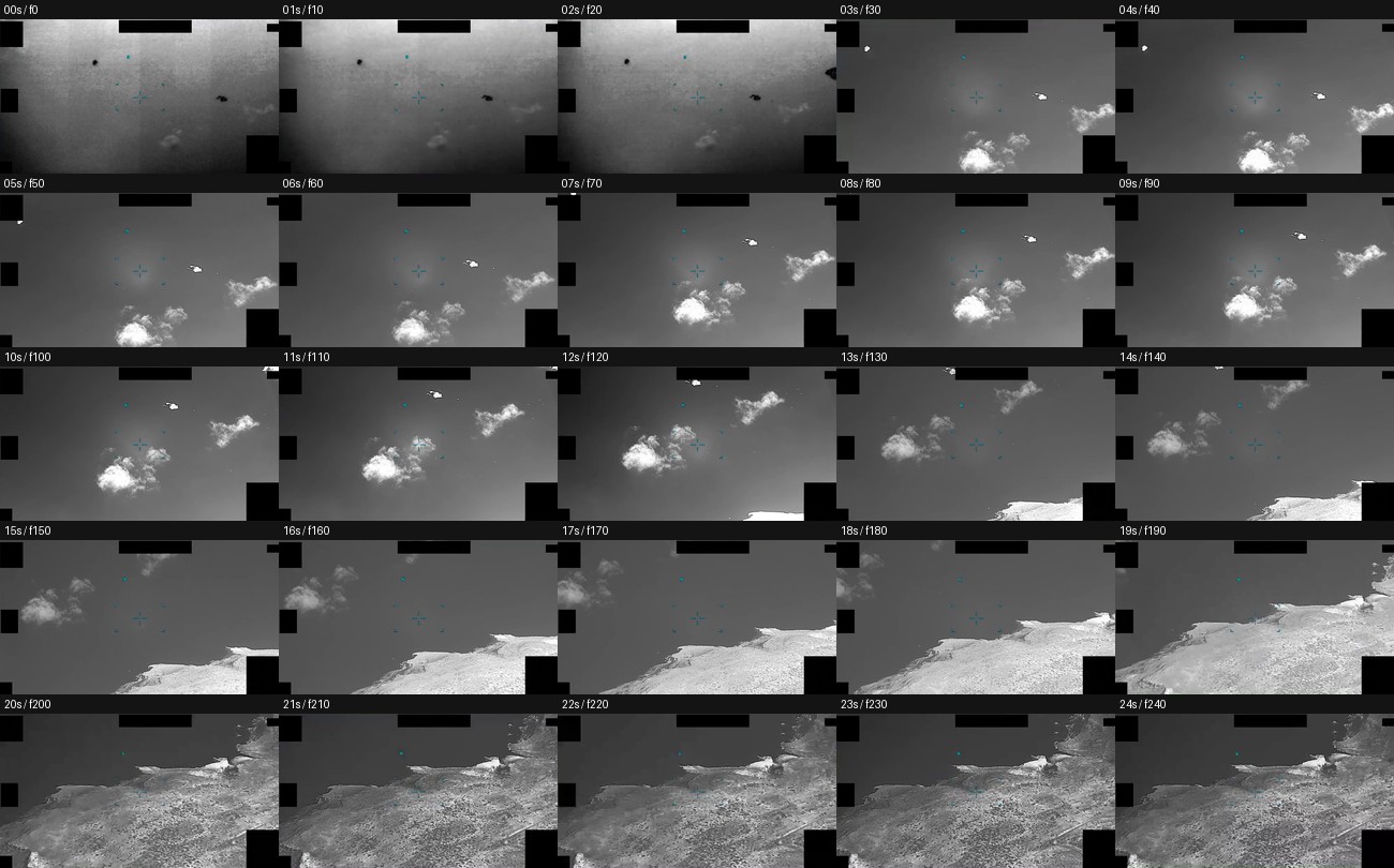 Whole-clip samples at one-second intervals show the masked grayscale sensor view, central display reticle, early cloud/water background, and later coastline/terrain transition. Tiny bright or dark specks remain unresolved at this scale.
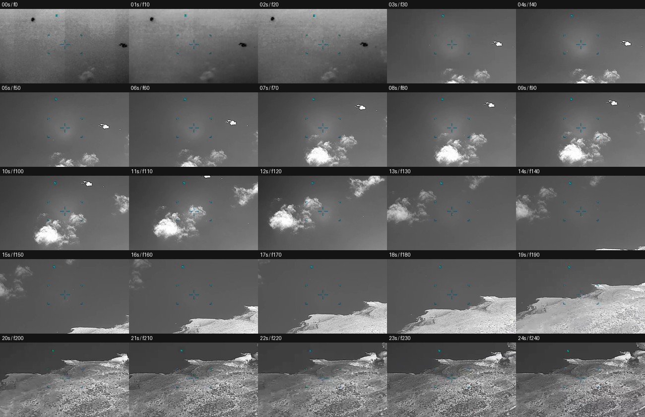 The center-field crop preserves the publisher-described tracking window and water-to-land transition. It is useful for orientation, but it does not establish a resolved object, range, size, speed, or independent motion.
Investigation reading
This page covers the PR35 video source item: DVIDS video 1006082, released in the WAR.GOV/PURSUE Release 01 corpus and associated in release metadata with DOW-UAP-D35, Mission Report, Greece, October 2023. The release-file copy was verified as a 2,406,930-byte MP4 with SHA-256 670077e60bca959cde784ae1595688d645397804d811a7f5a85912c60045d471. Media metadata reads as H.264 video, 800×444 pixels, 10 fps, about 24.5 seconds long. An AAC stereo audio stream is present, but volume analysis found it effectively silent at about -91.0 dB mean and maximum volume.
The publisher description says the United States Central Command submitted 24 seconds of infrared-sensor footage from a U.S. military platform in 2023. It describes the visible target as an “area of contrast,” says the sensor narrows field of view around 00:02, tracks the contrast area from about 00:03 to 00:19, and says that around 00:20, as the background transitions from water to land, the contrast area becomes indistinguishable. The paired D35 mission report describes the reported UAP as small and circular, flying near the ocean surface toward land. Those are source statements; this page does not convert them into a finding.
A whole-clip frame pass was performed across the released MP4, including the 00:02 field-of-view narrowing window, the 00:03–00:19 tracking interval, and the 00:20 water-to-land transition. The direct visual reading is conservative: the clip is a low-resolution grayscale sensor view with black masks/redactions, central cyan/teal reticle symbology, clouds or haze in the early sequence, and coastline/terrain entering the frame late in the sequence. A tiny bright or dark point/patch is intermittently visible in the early and mid-clip samples, but it is not visually resolved into a stable shape or structure in the public MP4 review. Motion, distance, size, altitude, and cause cannot be measured from these public frames alone.
What the file appears to contain
| Segment | Public reading |
|---|---|
| File format | Official MP4 video, about 24.5 seconds long, 800×444, 10 fps, H.264, with effectively silent AAC audio. |
00:00–00:02 | Grayscale sensor view with black masks/redactions and central display reticle. The background is low-contrast gray with faint cloud or haze texture and small unresolved specks/patches. |
00:02–00:06 | The publisher says the sensor narrows field of view to zoom in on an area of contrast. Sampled frames show bright cloud-like texture and a tiny high-contrast feature or speck in the upper field, but it remains point-like and unresolved. |
00:07–00:13 | Cloud/background structure becomes more prominent. The small bright feature is intermittently visible against the darker background and near edge/mask regions; frame samples do not show enough structure to classify it. |
00:14–00:19 | The scene transitions toward coastal context. Bright cloud/shoreline-like contrast and darker water/sky regions move through the field. Apparent feature movement cannot be separated from platform motion, sensor pan, stabilization, or background motion using the public clip alone. |
00:20–end | Coastline and terrain occupy much of the lower/right field while darker water remains above/left. This matches the release description’s water-to-land transition and the contrast area becoming indistinguishable, but it does not independently identify the source of the earlier contrast feature. |
The key distinction is between scene content and the display layer. The black rectangles are masking/redaction or video-window boundaries. The cyan/teal reticle and ticks are display symbology. Contact-sheet timestamps are review labels. None of those elements should be read as physical objects in the scene.
Source custody and provenance
- Official/source URL: DOW-UAP-PR35, Unresolved UAP Report, Greece, October 2023
- Open released file: war-gov-dow-uap-pr35-unresolved-uap-report-greece-october-2023-1006082
- SHA-256:
670077e60bca959cde784ae1595688d645397804d811a7f5a85912c60045d471 - File size checked:
2,406,930bytes - Media metadata checked:
24.5seconds,800×444,10 fps, H.264 video, AAC stereo audio effectively silent in the released file. - DVIDS video ID:
1006082; graph asset ID:official:video:war-pursue-uap-release:dvids-1006082. - The official DVIDS source page was reachable, and the official CloudFront MP4 byte-range response returned MP4
ftypM4Vmagic with total size2,406,930bytes. - Release-row provenance needs cleanup: video source metadata surfaces rows
52and92, the exact PR35 release record also surfaces row89, and the paired D35 PDF page records rows49and89. Treat these row-number differences as a metadata audit lead, not an evidentiary conclusion.
Graph context
The evidence graph has an exact VideoEvidence record for DVIDS 1006082 and an exact Release 01 record for the PR35 video item. It also surfaces the paired D35 mission-report record and D35 PDF asset. The semantic layer for this PR35 video item currently reports 17 extracted claims, 11 entity mentions, no extracted sensor-event records, and no extracted table rows.
The extracted claims are dominated by the official release description: Department of War / AARO / DVIDS references, Greece/Aegean location terms, D35/PR35 identity, the 24-second infrared footage statement, the operator-reported near-ocean-surface description, the small/circular wording from D35, and the publisher caution that the video description is informational rather than an analytical judgment. These graph facts are useful navigation cues, not adjudicated findings.
Candidate crosslinks around Greece, Syria, older UFO collections, and general anomaly literature are lexical or batch-neighbor leads. They do not establish corroboration. The strongest local context is the release-stated pairing with D35, which should be used for report fields and timing comparison while keeping the video-frame reading separate from the redacted MISREP text.
Leads to check
- Compare PR35 frame timing against the D35 source fields:
0811Z, estimated30 MPH, near-ocean-surface wording, “straight above the ocean toward land,” and feed-lost-at-0811Zlanguage. - Review the continuous MP4 for apparent tracking behavior, not only still samples: field-of-view change, reticle behavior, platform/sensor pan, edge masking, and the moment when the water-to-land background makes the contrast feature indistinguishable.
- Run prosaic correlation checks before escalation: sea-surface traffic or wakes, birds, clouds, surf/shoreline contrast, sensor bloom/noise, compression, stabilization, platform parallax during return-to-base, local weather/visibility, and any recoverable maritime/air traffic context.
- Reconcile row-number and pairing metadata across the release CSV, release metadata, graph records, PR35 video item, and D35 PDF item.
- Preserve the D35 report limits when comparing sources: no public range, full coordinates, platform track, sensor calibration, altitude, thermal polarity, or independent corroborating sensor data are provided in the public video page.
Lead check notes
- Checked — PR35 video source and visual timing: The Open Sky release-file copy is hash-verified as DVIDS
1006082, and frame-derived contact sheets from the official MP4 cover the publisher-described00:02field-of-view narrowing,00:03–00:19tracking interval, and the00:20water-to-land background transition. The sheets show sensor-display masks/reticle, cloud or haze texture, a tiny unresolved bright feature in several early-to-mid frames, and later coastline/terrain context; they do not identify the feature or establish range, size, altitude, or independent motion. - Partial — D35 mission-report comparison: The paired D35 page/source fields support the
0811Zreport time, estimated30 MPH, near-ocean-surface/toward-land wording, and lost-feed-at-0811Zlanguage. That is consistent with the PR35 release description at a source-summary level, but the public MP4 does not expose platform track, range, sensor settings, or a direct mapping from video seconds to the MISREP time fields. - Needs external source — prosaic/environment checks: Sea-surface traffic or wakes, birds, clouds/surf/shoreline contrast, sensor bloom/noise/compression, stabilization/parallax, weather/visibility, maritime or air traffic, satellite, launch/reentry, and drone checks remain open because the public sources do not provide unredacted coordinates, collection geometry, platform motion, or raw sensor data.
- Partial — row and pairing metadata: The video source metadata preserves DVIDS
1006082and PR35/D35 pairing, while row references differ across the release metadata and graph context (52,92,89, and the paired D35 rows49/89). Treat this as a provenance-cleanup lead, not as evidence for or against the sighting. - Checked — source-level limits: The PR35 source is a short, low-resolution, effectively silent MP4 with display symbology and masking/redaction. The paired D35 PDF supplies form fields and narrative context but not full coordinates, platform identity, range, calibration, altitude, raw FMV export metadata, independent corroborating sensor data, or a resolved identification.
Deep investigation — graph + web reconnaissance
Source reread and media check
The deep pass keeps PR35 and the paired D35 report separated by evidence type. PR35 is the DVIDS video item (1006082), verified here as a 2,406,930-byte MP4 with SHA-256 670077e60bca959cde784ae1595688d645397804d811a7f5a85912c60045d471. The live DVIDS page returned the title DOW-UAP-PR35, Unresolved UAP Report, Greece, October 2023, VIRIN 231002-D-D0360-7307, date taken 10.01.2023, date posted 05.08.2026 07:48, location GR, and category B-Roll. The official CloudFront MP4 byte-range also returned 206 with Content-Range: bytes 0-31/2406930 and MP4 ftypM4V magic.
The paired D35 PDF remains the source for report-form details rather than video measurement. Its source text anchors the mission around LGLR, FMV/SIGINT collection, AN/DAS-4, AH/GMESH, initial contact 290811:00ZOCT23, observer assessment Benign, physical state Solid, propulsion UNK, no intelligent control, no signatures, no effects, and the page-7 wording SEEMINGLY CIRCULAR, TOO SMALL TO MAKE OUT DETAILS. The D35 narrative says the operator was RTB when a UAP was spotted just above the ocean surface and flying toward land, then the feed was lost shortly after. Those are source statements; they are not a resolved track, range, altitude, or object identification.
Video-frame reading
The released MP4 and derived contact sheets support the publisher's broad timing description: field-of-view narrowing near 00:02, a reported tracking interval around 00:03-00:19, and a water-to-land or coastline/terrain transition around 00:20. A fresh visual review of the contact sheets shows fixed display symbology/reticle, black mask or redaction boundaries, cloud or haze texture early and mid-clip, and coastline/terrain entering later. Small bright or dark point-like marks appear in some frames, but they are not resolved enough to classify and cannot be reliably separated from background motion, cloud edges, compression, sensor-display artifacts, or platform/sensor movement in the public clip alone.
Read-only graph connections
The graph contains an exact VideoEvidence node for official:video:war-pursue-uap-release:dvids-1006082, with DVIDS/CloudFront URLs, SHA-256, 2,406,930 bytes, incident-location terms Aegean Sea and Greece, and related CSV rows 52 and 92. The PR35 semantic layer currently has 17 machine-extracted claims and 11 entity mentions; it has no PR35-specific SensorEvent rows. Its extracted claims mainly preserve source identity, AARO/DVIDS/Department of War terms, the 24-second infrared-footage description, Greece/Aegean terms, and the D35 pairing.
The paired D35 PDF asset is separately modeled as an exact Document with SHA-256 b4f4f4ce6dc7687a543905990671f999cd6c5a9e579159bfda501bf6d04f4445, 1,415,369 bytes, seven OCR pages, seven frontier-OCR chunks, and related rows 49 and 89. Its semantic layer has 113 machine-extracted claims, 81 entity mentions, and 9 machine-extracted sensor-event rows. Source-supported sensor context is FMV / G-MESH / AN/DAS-4 as form fields; radar, RWR, IR, and aircraft sensor rows include checklist or equipment-text extractions and remain machine_extracted_needs_human_review / not_a_finding unless verified against source text.
Graph relationships and release records also expose row drift: D35/PR35 row records preserve row 49, the video asset lists rows 52 and 92, and a current PR35 record appears at row 89, while some stale row records carry neighboring D32/D42 file fields. Low-score CANDIDATE_CROSSLINK edges to CIA/AMS/general UFO collections are lexical or batch-neighbor leads only; they do not corroborate this video.
External provenance and context checks
Official DVIDS is currently the strongest live external source for PR35. It confirms the title, DVIDS ID, VIRIN/date metadata, B-roll category, and publisher description tying the clip to an infrared sensor aboard a U.S. military platform and the D35 mission report. WAR.GOV landing/CSV probes, AARO search, and Defense.gov search returned 403 in this environment; Internet Archive availability checks for the DVIDS page, MP4, and WAR.GOV CSV returned 429. Those access results are provenance/access notes, not evidence against the file, because the Open Sky release-file copy and official MP4 range response both verify the expected bytes.
The DVIDS date-taken/VIRIN metadata (10.01.2023 / 231002-D-D0360-7307) conflicts with the D35 mission-report event date/time (290811:00ZOCT23). Treat that as a provenance-reconciliation lead, not as a second event or a reason to merge unrelated records.
Prosaic checks and open questions
The first prosaic lane is source-internal: the public clip itself becomes indistinguishable near the water-to-land transition, and apparent small-feature motion cannot be separated from sensor slew, stabilization, platform parallax, background translation, masks, compression, or display symbology. External lanes remain open for sea-surface traffic or wakes, birds, clouds, glint, shore/surf contrast, sensor bloom or gain behavior, local weather/visibility, maritime and air traffic, drones, satellite/reentry, and launch context.
Narrow graph checks for 2023-10-28 through 2023-10-30 surfaced no modeled LaunchEvent rows and no modeled WeatherEvent rows for that window. One modeled AstronomyEvent in the window is a 2023-10-30T07:22:55Z fireball at approximately (-42.9, -44.7), which is not a same-time Aegean correlate. These graph results are coverage-limited checks, not exclusions.
Open follow-up needs are the unredacted coordinates and platform track, raw or less-compressed FMV, sensor mode/FOV/calibration, time mapping from PR35 video seconds to D35 report time, weather and sea-state data near the redacted 35SMV grid fragment, traffic/maritime context, and release-row cleanup across D35/PR35 records. No finding, hypothesis, or resolution decision is asserted from this public material.
Limits
This draft does not identify the object, resolve the event, or assert a hypothesis. It records a source-level reading of the official MP4 and associated release description.
The video is short, compressed, low-resolution, and mediated by sensor display symbology, masking/redaction blocks, frame-edge cropping, possible stabilization, and missing platform/sensor geometry. Still-frame contact sheets are useful for orientation but cannot establish a full trajectory or separate apparent target motion from sensor/platform/background motion.
The paired D35 PDF supplies source-text context, but it is a redacted mission-report form. Its reported speed, description, and feed-loss wording should stay separated from direct video measurement unless later reviewed material provides range, platform track, sensor settings, and environmental context.
Sources
- Department of War / DVIDS:
DOW-UAP-PR35, Unresolved UAP Report, Greece, October 2023, DVIDS video1006082, official URL above. - Open Sky verified release-file copy for this slug, SHA-256
670077e60bca959cde784ae1595688d645397804d811a7f5a85912c60045d471. - Paired Open Sky page: DOW-UAP-D35, Mission Report, Greece, October 2023.
- Release 01 CSV/DVIDS metadata and graph records for
official:video:war-pursue-uap-release:dvids-1006082and associated D35/PR35 records.